| Early-Mid January Heavy Rainfall Event |
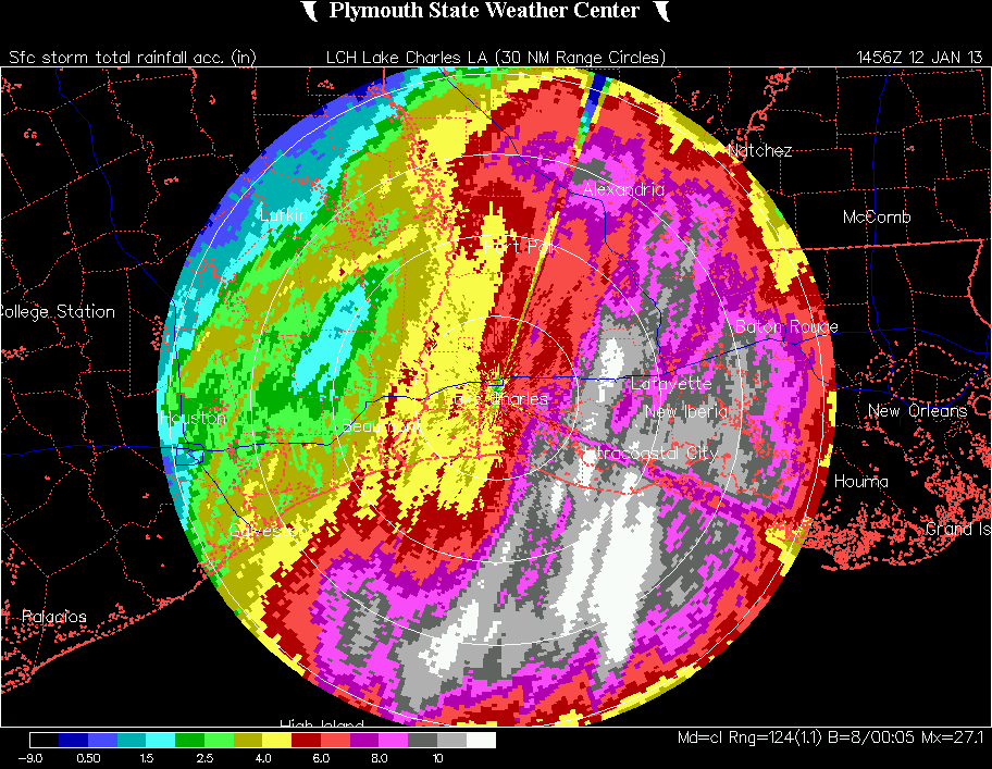
Lake Charles Doppler Radar estimate of total rainfall through Saturday morning the 13th. Notice the scale on the bottom left denoting estimated total inches of rainfall. Image courtesy of Plymouth State University. |
| |
| A progressive weather pattern across the Gulf South brought a series of cold fronts, and their accompanying brief shots of heavy rain, to the region during early January...with much of Southwest Louisiana and Southeast Texas already receiving well above-normal rainfall for the first week of the year. By the 9th, an area of low pressure developed over the northwestern Gulf of Mexico which moved northeast, pulling a warm front and its associated rains across the region. A round of heavier rains then initiated early on the 10th as a cold front moved into the area and stalled...hanging around the Atchafalaya Basin into the 11th. More scattered rains fell on the 12th as another cold front approached the area. However its passage on the 13th set the stage for another, and longer, round of persistent rains as warm air aloft rode over the colder air left in the wake of the front. These rains continued through mid-week, before an area of low pressure aloft finally crossed the western Gulf states, ushering in drier air through the atmosphere. |
| |
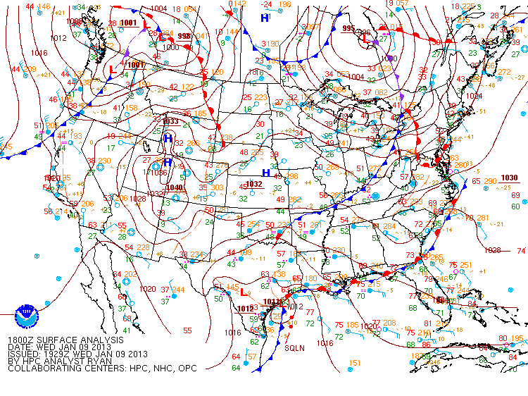
A series of surface analysis maps, courtesy of the Hydrologic Prediction Center, NWS. |
| |
| Below is a list of 9-day rainfall totals resulting from the heavy rainfall/severe weather event starting on Tuesday, January 8th...running through the lingering over-running rainfall event which finally ended on Thursday the 17th. |
| LOCATION |
TYPE |
WED
1/9 |
THU
1/10 |
FRI
1/11 |
SAT
1/12 |
SUN
1/13 |
MON
1/14 |
TUE
1/15 |
WED
1/16 |
THU
1/17 |
TOTAL |
| EUNICE |
co-op |
1.09 |
11.16 |
0.41 |
0.63 |
|
0.94 |
1.41 |
1.21 |
0.07 |
16.92 |
| JENNINGS |
co-op |
0.77 |
8.64 |
0.29 |
0.48 |
|
1.28 |
1.37 |
1.00 |
0.03 |
13.86 |
| CROWLEY 2NE |
co-op |
1.38 |
9.35 |
0.50 |
|
|
1.15 |
0.18 |
0.80 |
0.02 |
13.38 |
| BUNKIE |
co-op |
0.38 |
8.45 |
0.60 |
0.08 |
|
0.36 |
0.67 |
1.50 |
0.08 |
12.12 |
| LAFAYETTE CADE FARM |
raws |
|
1.43 |
1.90 |
0.02 |
|
7.75 |
0.08 |
0.60 |
0.04 |
11.82 |
| ROCKEFELLER NWR |
co-op |
1.12 |
8.75 |
|
|
|
0.74 |
0.20 |
0.50 |
0.02 |
11.33 |
| FRANKLIN 3NW ^ |
co-op |
5.57 |
0.70 |
2.60 |
0.44 |
|
0.29 |
1.30 |
0.12 |
0.03 |
11.05 |
| MORGAN CITY |
co-op |
3.49 |
0.28 |
3.58 |
2.94 |
|
0.51 |
|
0.05 |
0.09 |
10.94 |
| ABBEVILLE |
co-op |
3.20 |
3.92 |
1.53 |
0.07 |
|
1.51 |
0.25 |
0.22 |
0.02 |
10.72 |
| LACASSINE |
raws |
0.45 |
7.49 |
0.27 |
|
|
0.79 |
0.68 |
0.63 |
0.01 |
10.32 |
| SALT POINT |
asos |
3.94 |
0.48 |
3.30 |
1.60 |
|
0.56 |
0.05 |
0.01 |
0.09 |
10.03 |
| CENTRAL LAFAYETTE |
other |
|
*8.59 |
|
|
|
+1.34 |
|
|
|
9.93 |
| ALEXANDRIA ESLER AIRPORT |
asos |
0.36 |
7.30 |
0.47 |
0.26 |
|
0.79 |
0.09 |
0.51 |
0.04 |
9.82 |
| NEW IBERIA |
asos |
3.88 |
1.10 |
2.59 |
0.03 |
|
2.10 |
0.06 |
|
0.02 |
9.78 |
| JEANERETTE 5NW |
co-op |
5.06 |
0.85 |
1.38 |
|
|
1.46 |
0.86 |
|
|
9.61 |
| KAPLAN |
co-op |
3.27 |
4.05 |
0.93 |
|
|
1.27 |
|
|
|
9.52 |
| OPELOUSAS |
co-op |
|
7.79 |
|
|
|
|
0.25 |
0.90 |
0.13 |
9.07 |
| ALEXANDRIA POWER PLANT |
co-op |
0.40 |
5.80 |
0.25 |
0.10 |
|
1.10 |
0.10 |
0.63 |
|
8.38 |
| ELMER 2SW |
co-op |
0.42 |
6.01 |
0.19 |
0.12 |
0.01 |
0.93 |
0.10 |
0.37 |
0.03 |
8.18 |
| LAFAYETTE |
asos |
2.67 |
1.88 |
1.82 |
0.03 |
|
1.31 |
0.11 |
0.28 |
0.06 |
8.16 |
| CHENEYVILLE 5W |
co-op |
0.23 |
5.47 |
0.44 |
0.11 |
|
0.51 |
0.27 |
0.94 |
0.02 |
7.99 |
| BOYCE 3WNW ^ |
co-op |
0.55 |
3.64 |
2.58 |
|
0.10 |
0.57 |
0.20 |
0.17 |
0.15 |
7.96 |
| OBERLIN FIRE TOWER |
co-op |
0.31 |
6.22 |
0.13 |
|
|
0.04 |
0.12 |
0.95 |
|
7.77 |
| GARDNER |
raws |
0.44 |
5.14 |
0.34 |
0.27 |
|
0.88 |
0.06 |
0.44 |
0.02 |
7.59 |
| ALEXANDRIA 5SSE ^ |
co-op |
0.35 |
3.51 |
2.55 |
0.02 |
0.11 |
0.43 |
0.02 |
0.45 |
0.03 |
7.47 |
| KINDER |
co-op |
0.30 |
5.90 |
0.10 |
0.20 |
|
|
0.10 |
0.80 |
|
7.40 |
| FULLERTON |
raws |
0.53 |
5.39 |
0.09 |
0.07 |
|
0.47 |
0.39 |
0.26 |
0.01 |
7.21 |
| SAM HOUSTON JONES S.P. |
co-op |
0.60 |
5.60 |
0.05 |
0.11 |
0.02 |
|
0.10 |
0.50 |
0.03 |
7.01 |
| DRY CREEK |
co-op |
|
6.68 |
|
|
|
|
|
0.32 |
|
7.00 |
| LAFAYETTE |
co-op |
|
3.25 |
1.45 |
|
|
1.45 |
0.30 |
0.25 |
0.25 |
6.95 |
| MITTIE |
co-op |
0.22 |
4.77 |
0.15 |
0.10 |
|
0.52 |
0.09 |
0.58 |
0.02 |
6.45 |
| ALEXANDRIA INTL |
asos |
0.40 |
4.39 |
0.01 |
0.17 |
0.02 |
0.75 |
0.28 |
0.24 |
0.03 |
6.29 |
| FT. POLK-FULLERTON |
asos |
0.65 |
5.00 |
0.10 |
0.06 |
|
|
0.19 |
0.19 |
0.01 |
6.20 |
| CAMERON PRAIRIE NWR |
co-op |
0.55 |
4.90 |
0.14 |
|
|
0.50 |
|
|
|
6.09 |
| MOSS BLUFF 2NNW ^ |
co-op |
0.12 |
2.85 |
2.38 |
0.01 |
0.05 |
|
0.07 |
0.46 |
0.08 |
6.02 |
| LAKE CHARLES |
asos |
0.32 |
4.69 |
0.14 |
|
|
0.05 |
0.12 |
0.60 |
|
5.92 |
| MOSS BLUFF |
co-op |
0.28 |
4.53 |
0.07 |
0.12 |
|
0.14 |
0.16 |
0.54 |
|
5.84 |
| SALTWATER BARRIER |
co-op |
0.24 |
4.30 |
0.11 |
0.05 |
0.02 |
0.11 |
0.16 |
0.50 |
0.04 |
5.53 |
| OAKDALE |
co-op |
|
5.15 |
|
|
|
|
|
0.38 |
|
5.53 |
| LEESVILLE |
co-op |
0.93 |
3.05 |
0.02 |
0.23 |
|
0.51 |
0.62 |
0.14 |
|
5.50 |
| LAKE CHARLES CHENNAULT |
awos |
0.28 |
4.47 |
0.08 |
0.02 |
|
0.08 |
0.12 |
0.44 |
|
5.49 |
| LEESVILLE 6SSW |
co-op |
1.15 |
3.42 |
|
|
|
0.80 |
|
0.11 |
|
5.48 |
| PORT OF LAKE CHARLES |
co-op |
0.37 |
4.15 |
0.08 |
0.02 |
|
0.08 |
0.12 |
0.52 |
|
5.34 |
| FT. POLK-SELF STRIP |
asos |
0.88 |
3.19 |
0.07 |
0.12 |
0.13 |
0.44 |
0.27 |
0.20 |
0.01 |
5.31 |
| ORANGE 9N |
co-op |
0.28 |
3.45 |
0.70 |
0.12 |
0.01 |
0.25 |
0.08 |
0.21 |
0.01 |
5.11 |
| HACKBERRY 8SSW |
co-op |
0.40 |
3.65 |
0.06 |
|
|
0.14 |
0.15 |
0.63 |
0.01 |
5.04 |
| BEAUMONT PT. ARTHUR AIRPORT |
asos |
0.38 |
4.19 |
0.01 |
0.06 |
0.04 |
0.04 |
0.07 |
0.22 |
0.02 |
5.03 |
| TOLEDO BEND RESERVOIR |
co-op |
1.52 |
2.10 |
|
0.30 |
|
0.49 |
0.41 |
0.13 |
0.02 |
4.97 |
| BUNA |
raws |
0.59 |
3.24 |
|
0.05 |
0.10 |
0.52 |
0.35 |
0.08 |
|
4.93 |
| FT. POLK AAF |
asos |
0.84 |
2.92 |
0.07 |
0.08 |
0.06 |
0.44 |
0.22 |
0.18 |
|
4.81 |
| COLMESNEIL 4E |
co-op |
2.29 |
1.36 |
|
|
0.34 |
0.34 |
0.32 |
0.09 |
|
4.74 |
| OBERLIN |
co-op |
0.27 |
3.79 |
|
|
|
0.14 |
0.16 |
0.35 |
0.01 |
4.72 |
| SABINE |
raws |
0.49 |
3.16 |
0.10 |
|
0.03 |
0.06 |
0.12 |
0.60 |
0.01 |
4.57 |
| SILSBEE 4N |
co-op |
0.60 |
2.90 |
|
0.05 |
0.30 |
0.05 |
0.40 |
|
|
4.30 |
| LELAND BOWMAN LOCKS |
co-op |
|
|
1.57 |
|
|
2.32 |
0.13 |
0.21 |
0.04 |
4.27 |
| OLD TOWN BAY |
co-op |
0.29 |
2.38 |
0.32 |
0.04 |
|
0.15 |
0.20 |
0.84 |
|
4.22 |
| LUMBERTON |
co-op |
0.72 |
2.70 |
|
0.05 |
0.10 |
0.30 |
0.30 |
|
|
4.17 |
| BEAUMONT |
co-op |
0.55 |
2.83 |
|
0.02 |
0.01 |
0.38 |
0.17 |
0.10 |
|
4.06 |
| MCFADDIN |
raws |
0.29 |
2.95 |
0.01 |
|
0.03 |
0.05 |
0.05 |
0.26 |
|
3.64 |
| BEAUMONT RESEARCH CENTER |
co-op |
0.78 |
2.34 |
|
0.04 |
0.05 |
0.27 |
0.12 |
0.03 |
|
3.63 |
| WOODVILLE |
raws |
0.91 |
1.40 |
0.01 |
0.14 |
0.31 |
0.57 |
0.08 |
0.09 |
|
3.51 |
| HARMONY |
co-op |
0.93 |
1.35 |
|
0.23 |
0.50 |
0.30 |
0.11 |
0.07 |
|
3.49 |
| SOUR LAKE |
co-op |
0.70 |
1.84 |
|
0.01 |
0.01 |
0.38 |
0.30 |
0.04 |
|
3.28 |
| FRED |
co-op |
0.58 |
1.88 |
|
|
|
|
0.66 |
0.07 |
|
3.19 |
| CHESTER 1SE |
co-op |
1.75 |
1.13 |
|
|
|
0.24 |
|
|
|
3.12 |
| SULPHUR |
awos |
0.23 |
2.74 |
0.01 |
|
|
0.02 |
|
0.04 |
|
3.04 |
| WARREN |
raws |
0.54 |
1.22 |
|
0.01 |
0.15 |
0.91 |
0.09 |
0.06 |
|
2.98 |
| STEINHAGEN LAKE |
co-op |
0.36 |
1.32 |
|
0.02 |
0.84 |
0.18 |
0.16 |
0.08 |
|
2.96 |
| WILDWOOD |
co-op |
0.65 |
1.30 |
|
0.05 |
0.26 |
0.54 |
0.07 |
0.07 |
|
2.94 |
| WOODVILLE 7ENE |
co-op |
0.56 |
1.38 |
|
|
|
0.63 |
0.16 |
0.05 |
|
2.78 |
| PORT ARTHUR |
co-op |
|
2.30 |
|
|
|
0.16 |
0.06 |
0.21 |
0.03 |
2.76 |
| SPURGER 1NE |
co-op |
0.30 |
1.37 |
|
|
0.35 |
0.50 |
0.19 |
0.04 |
|
2.75 |
| CARENCRO |
co-op |
|
|
1.19 |
|
|
0.95 |
|
0.42 |
|
2.56 |
| JASPER |
awos |
0.44 |
1.29 |
|
|
0.07 |
0.37 |
0.04 |
0.01 |
|
2.22 |
| DERIDDER |
co-op |
0.51 |
|
0.43 |
0.11 |
0.03 |
0.72 |
0.23 |
0.11 |
0.03 |
2.17 |
| WOODVILLE |
co-op |
0.55 |
1.40 |
|
|
|
|
0.09 |
0.05 |
|
2.09 |
| IVANHOE |
co-op |
0.68 |
|
|
0.19 |
0.34 |
0.65 |
0.17 |
|
|
2.03 |
| DERIDDER |
awos |
0.29 |
1.43 |
|
0.07 |
0.02 |
|
0.04 |
0.13 |
|
1.98 |
| SHADY GROVE |
co-op |
1.70 |
0.24 |
|
|
|
|
|
|
|
1.94 |
| SAM REYBURN RESERVOIR |
co-op |
|
|
|
0.01 |
0.40 |
0.52 |
0.25 |
0.10 |
|
1.28 |
| WOODVILLE 2W |
co-op |
|
|
|
0.10 |
0.60 |
0.10 |
0.20 |
|
|
1.00 |
| ORANGE |
awos |
0.01 |
0.23 |
0.38 |
0.27 |
0.02 |
0.01 |
0.01 |
0.01 |
|
0.94 |
|
|
- Individual totals are for the 24 hours ending at 0700 or 0800 for the day listed above the column, except for the following...
^ ending 0000 the day listed above the column * 72-hour total ending 2000 + 4-day total ending 2000
|
| - Blank cells indicate periods in which no rain was reported, a trace amount was reported, or no report was received |
| - All data is considered unofficial...official data should be available via the National Climatic Data Center starting February 1st, 2013 |
|
- Location type glossary
co-op: Cooperative Reporting Station asos: NWS or DOD Automated Observing Station
awos: FAA Automated Observing Station raws: Interagency Remote Automated Weather Observing Stations
other: Miscellaneous report
|
| |
| The following list is 48-hour rainfall amounts, ending at 1800 on Thursday the 10th for sites within the Calcasieu Parish Alert Network. All roads are located in or near Lake Charles unless noted. |
| IOWA |
6.73 |
| HECKER ROAD |
6.26 |
| JOE SPEARS ROAD |
6.38 |
| WARD LINE ROAD |
6.03 |
| KAYOUCHEE COULEE PUMP STATION |
5.71 |
| GOOS ROAD |
5.67 |
| MARK LEBLEU ROAD |
5.63 |
| BANKENS ROAD |
5.63 |
| COFFEY ROAD |
5.35 |
| ELLIOT ROAD |
5.27 |
| DOUGLAS ROAD |
5.04 |
| TOPSY ROAD |
5.00 |
| NELSON ROAD |
5.00 |
| HIGHWAY 90 (SULPHUR) |
4.61 |
| EAST PRIEN LAKE ROAD |
4.29 |
| HIGHWAY 27 (CARLYSS) |
4.18 |
| PICARD STREET |
4.09 |
| DAVE DUGAS ROAD (CARLYSS) |
3.90 |
| CURRIE DRIVE |
3.74 |
| BOYS VILLAGE ROAD |
3.42 |
|
| |
| The following are other 3-day totals ending on Thursday the 10th. |
| WEST EUNICE |
13.80 |
| EAST MAMOU |
12.75 |
| LA 335 NR COW ISLAND |
12.00 |
| NEW IBERIA |
11.40 |
| SAINT MARTINVILLE COURTHOUSE |
10.60 |
| LAKE ARTHUR |
9.25 |
| HILLSIDE DRIVE (LAFAYETTE) |
8.59 |
| 7 EAST OF ALEXANDRIA |
8.23 |
| LAFAYETTE KATC |
8.03 |
| DOWNTOWN ALEXANDRIA KALB TV |
6.34 |
|
| |
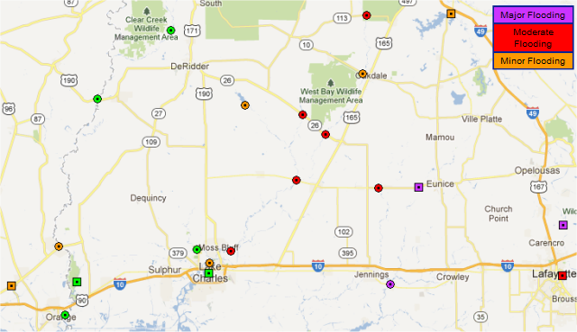
| The result of all this rain was a localized flash flood and widespread river flood event...for further details on continuing flooding, please refer to our Advanced Hydrology Prediction Service page. |
 |
| |
| The following is a list of area waterways which went into flood, and their record flood height for comparison. |
| Body of Water |
Location |
Flood Stage |
Crest |
Date of Crest |
Category of Flooding |
Record Crest |
Date of Record |
| Mermentau River |
Mermentau |
4 |
10.5 |
1/15/13 |
major |
14.5 |
8/7/1940 |
| Bayou Des Cannes |
Eunice |
16 |
21.4 |
1/12/13 |
major |
22.4 |
5/20/1953 |
| Bayou Vermilion |
Carencro |
17 |
21.5 |
1/11/13 |
major |
22.5 |
3/12/2012 |
| Calcasieu River |
Old Town Bay |
4 |
7.6 |
1/14/13 |
moderate |
16.1 |
5/21/1953 |
| Whisky Chitto Creek |
Mittie |
15 |
21.4 |
1/12/13 |
moderate |
32.8 |
5/18/1953 |
| Bayou Vermilion |
Lafayette (Surrey St) |
10 |
14.0 |
1/10/13 |
moderate |
24.9 |
8/9/1940 |
| Calcasieu River |
Oberlin |
13 |
18.2 |
1/15/13 |
moderate |
26.5 |
5/19/1953 |
| Calcasieu River |
Glenmora |
12 |
16.4 |
1/12/13 |
moderate |
21.6 |
5/19/1953 |
| Calcasieu River |
Kinder |
16 |
20.6 |
1/13/13 |
moderate |
32.0 |
5/19/1953 |
| Bayou Nezpique |
Basile |
22 |
26.1 |
1/13/13 |
moderate |
34.4 |
5/20/1953 |
| Calcasieu River |
Saltwater Barrier |
4 |
4.7 |
1/13/13 |
minor |
13.0 |
10/1/1913 |
| Calcasieu River |
Oakdale |
12 |
13.9 |
1/13/13 |
minor |
22.6 |
5/19/1953 |
| Cow Bayou |
Mauriceville |
17 |
17.9 |
1/10/13 |
minor |
22.5 |
10/29/2006 |
| Bayou Cocodrie |
Clearwater |
19 |
20.0 |
1/13/13 |
minor |
26.7 |
5/18/1953 |
| Bundick Creek |
Bundick Lake |
97 |
98.1 |
1/11/13 |
minor |
102.2 |
3/22/2012 |
| Sabine River |
Deweyville |
24 |
24.2 |
1/14/13 |
minor |
29.2 |
7/6/1989 |
|
| |
| |
| |


 Follow us on YouTube