|
NOVEMBER 7 1957 |
| research (2009) and webpage by Sam Shamburger, forecaster |
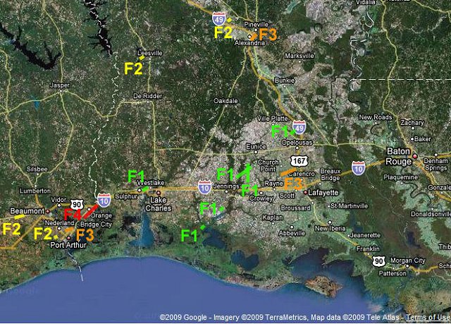
| Map of all tornadoes in the outbreak |
 |
OVERVIEW
One of the worst tornado outbreaks ever recorded across Southeast Texas and Southwest Louisiana occurred 50 years ago on November 7, 1957. On that day, 10 people were killed and hundreds were injured by at least 14 separate tornadoes that struck this area over a 10 hour period. Even more tornadoes affected other parts of Louisiana, as well as other states throughout the Southeastern U.S. Ironically, this large tornado outbreak occurred only a few months after the deadliest natural disaster in the area's history - Hurricane Audrey.
In 2009, the author did extensive additional research on the November 7, 1957 tornado outbreak, utilizing internet resources and library archives throughout Southeast Texas and Louisiana. This research found numerous errors in both the official National Weather Service Storm Data tornado database, and the widely-used tornado research book Significant Tornadoes by Tom Grazulis. One such example includes the "Boyce-Alexandria tornado", which clearly consisted of two different tornadoes that impacted Boyce and Alexandria separately. All of the corrected information utilizing the new research, including updated path maps, is listed on this webpage.
The November 7, 1957 Tornado Outbreak was unique among tornado outbreaks in Southeast Texas and Southwest Louisiana in that it produced numerous intense and killer tornadoes, with 5 different tornadoes causing fatalities across the area. This was despite the relatively small path widths and lengths of the tornadoes, such as compared to the large tornadoes that frequent the Plains states and Midwest. In addition, an F4 tornado which struck Orange County on this day remains the strongest tornado ever recorded in Southeast Texas. Several other tornadoes were rated F3 on the Fujita Scale, including very damaging ones in Groves TX and Alexandria LA. Damage totals across the area were around $5 million, which would equate to around $37 million in today's dollars.
Other tornadoes affected northern and southeastern Louisiana (2), Mississippi (4), Alabama (2), Tennessee (1), Georgia (2), and North Carolina (1), from November 7th into November 8th, 1957, with a total of at least 21 tornadoes in this outbreak. Some of these tornadoes in other states also caused deaths and injuries. There were likely other tornadoes that were not recorded due to the relatively low population density of the southern U.S. and the limited radar technology of the time.
Historically, only one tornado event is known to have been deadlier than the November 7, 1957 tornado outbreak in Southeast Texas and Southwest Louisiana. This was the Alexandria tornado of April 4, 1923, which killed 15 people, injured 150, and caused $750,000 dollars in damage ($9 million in today's dollars). The worst tornado outbreak in the history of Louisiana occurred on April 24, 1908, when two separate tornado families (series of tornadoes), including the infamous Amite tornado, struck east-central and southeastern Louisiana and killed at least 85 people. (Grazulis 1993)
|
Tornadoes in the NWS Lake Charles CWA on November 7, 1957 |
||||||||
|
LOCATION |
COUNTY/ |
TIME |
F-SCALE RATING |
PATH LENGTH |
PATH WIDTH |
DEATHS |
INJURIES |
DAMAGE |
| Grand Prairie LA | ST LANDRY | 1420 | F1 | 2 | 50 | 0 | 0 | $25,000 |
| Lowry LA | CAMERON | 1430 | F1 | 1 | 50 | 0 | 0 | $2,500 |
| Andrus Cove LA | JEFFERSON DAVIS | 1500 | F1 | 1 | 50 | 0 | 0 | $25,000 |
| Gotts Cove LA | ACADIA | 1530 | F1 | 5 | 50 | 0 | 0 | $25,000 |
| Iota LA | ACADIA | 1730 | F1 | 5 | 50 | 0 | 1 | $25,000 |
| Nome/China TX | JEFFERSON | 2015 | F2 | 5 | 50 | 0 | 0 | $14,000 |
| Leesville LA | VERNON | 2035 | F2 | 1 | 50 | 0 | 0 | N/A |
| Boyce LA | RAPIDES | 2055 | F2 | 1 | 50 | 1 | 14 | $25,000 |
| Alexandria LA | RAPIDES | 2104 | F3 | 3 | 75 | 2 | 28 | $500,000 |
| Port Acres TX | JEFFERSON | 2110 | F2 | 1.5 | 70 | 0 | 1 | $75,000 |
| Groves TX | JEFFERSON | 2115 | F3 | 3 | 150 | 2 | 53 | $2,300,000 |
| Orange TX | ORANGE | 2125 | F4 | 6 | 200 | 2 | 50 | $1,500,000 |
| Mossville LA | CALCASIEU | 2220 | F1 | 1 | 25 | 0 | 0 | $25,000 |
| Higginbotham LA | ACADIA/ST. LANDRY | 2330 | F3 | 8 | 200 | 4 | 23 | $500,000 |
|
Other Severe Weather Reports in the NWS Lake Charles CWA |
||||
|
LOCATION |
COUNTY/ |
TIME |
SEVERE WEATHER REPORT |
NOTES |
| Southeast TX Regional Airport |
JEFFERSON | 2101 | TSTM WINDS | Sustained SE winds of 42 MPH |
| England AFB LA | RAPIDES | 2102 | SVR TSTM WIND GUST | SW 58 MPH (50 KTS) wind gust |
| Southeast TX Regional Airport |
JEFFERSON | 2107 | SVR TSTM WIND GUST | Sustained WSW winds of 56 MPH with gust to 76 MPH (66 KTS) |
| Vinton LA | CALCASIEU | 2140 | TSTM WIND GUST | Severe thunderstorm with high winds reported |
| Lake Charles Chennault Airport LA |
CALCASIEU | 2230 | TSTM WIND GUST | NW 48 MPH (42 KTS) wind gust |
| Lake Charles LA | CALCASIEU | 2230 | TSTM WIND DAMAGE | Hanger destroyed at McFillen Airpark (east of present-day Burton Coliseum). Numerous porches, roofs, and small buildings were destroyed in town. (Ross 1997) |
| Crowley LA | ACADIA | 2350 | TSTM WIND DAMAGE | High winds and power outages |
| Lafayette LA | LAFAYETTE | 2358 | TSTM WIND GUST | WNW 52 MPH (45 KTS) wind gust |
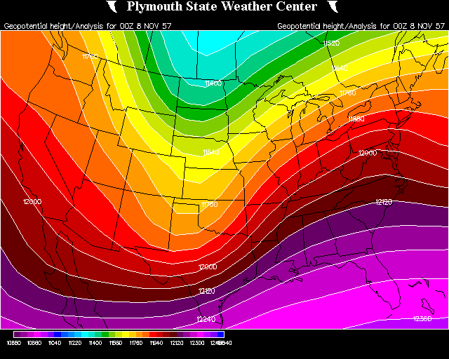
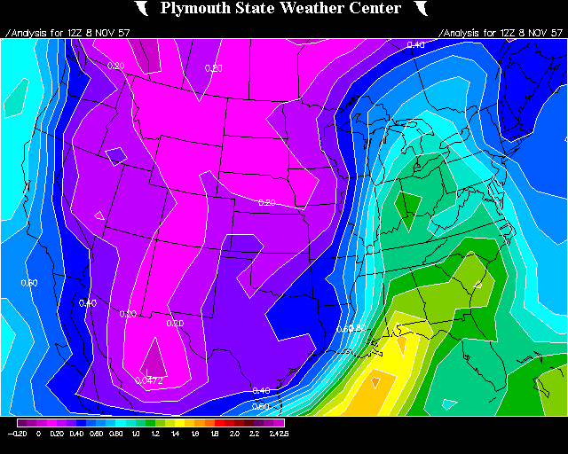
Surface & Upper Level Analysis
The weather ingredients for this tornado outbreak came together quite rapidly during the day on November 7, 1957, with numerous factors known today to be highly indicative of a major risk for severe weather. A large and deep positively-tilted trough of low pressure in the upper levels of the atmosphere, located over the western United States on November 6, 1957, moved quickly eastward and took on a negative-tilt as it reached the central United States by the evening of November 7. At the same time, a powerful 200 mb subtropical jet stream of around 120 knots (140 mph), located unusually far to the south, moved across northern Mexico into southern Texas.
Meanwhile, at the surface, rapid cyclogenesis likely occurred over central Texas early on November 7, with the evolving surface low deepening and moving quickly northeastward into southeastern Oklahoma by that evening. Deep gulf moisture characterized by dewpoints in the upper 60s and lower 70s, and precipitable water values in the 1.5 to 1.75 inch range, had become established across Southeast Texas and Southwest Louisiana during the day on November 7. Observed and modified upper air soundings show that by the evening of November 7, wind shear and instability levels were very favorable for tornadic supercells across Southeast Texas and Southwest Louisiana, with deep-layer wind shear values of around 70 knots (80 mph) and moderate to high CAPE values of 1500-2500 J/KG.
Local knowledge has found that unusually strong subtropical jet streams that move across northern Mexico into southern Texas have been associated with some of the worst severe weather outbreaks in our region. For instance, the tornado outbreak of November 23, 2004, occurred with a similar synoptic setup as the one on November 7, 1957. In addition, these powerful jet streams are common during moderate to strong El Niño events (although they can occur during neutral or La Niña events as well). A moderate El Niño event was in progress on November 7, 1957.
|
November 7, 1957 Tornado Outbreak |
||||||
|
DATE |
WINDS |
HEIGHTS |
VORTICITY ADVECTION |
PRECIPITABLE WATER |
MOISTURE CONVERGENCE |
UPPER AIR SOUNDINGS |
| November 6, 1957 at 6 pm (07/00Z) | 200 mb 500 mb 850 mb |
200 mb 500 mb 700 mb 850 mb 1000 mb |
500 mb | SFC to 100 mb | 850 mb | KLCH |
| November 7, 1957 at 6 am (07/12Z) | 200 mb 500 mb 850 mb |
200 mb 500 mb 700 mb 850 mb 1000 mb |
500 mb | SFC to 100 mb | 850 mb | KLCH |
| November 7, 1957 at 6 pm (08/00Z) | 200 mb 500 mb 850 mb |
200 mb 500 mb 700 mb 850 mb 1000 mb |
500 mb | SFC to 100 mb | 850 mb | KLCH |
| November 8, 1957 at 6 am (08/12Z) | 200 mb 500 mb 850 mb |
200 mb 500 mb 700 mb 850 mb 1000 mb |
500 mb | SFC to 100 mb | 850 mb | KLCH |
|
November 6-8, 1957 |
|||


 Follow us on YouTube