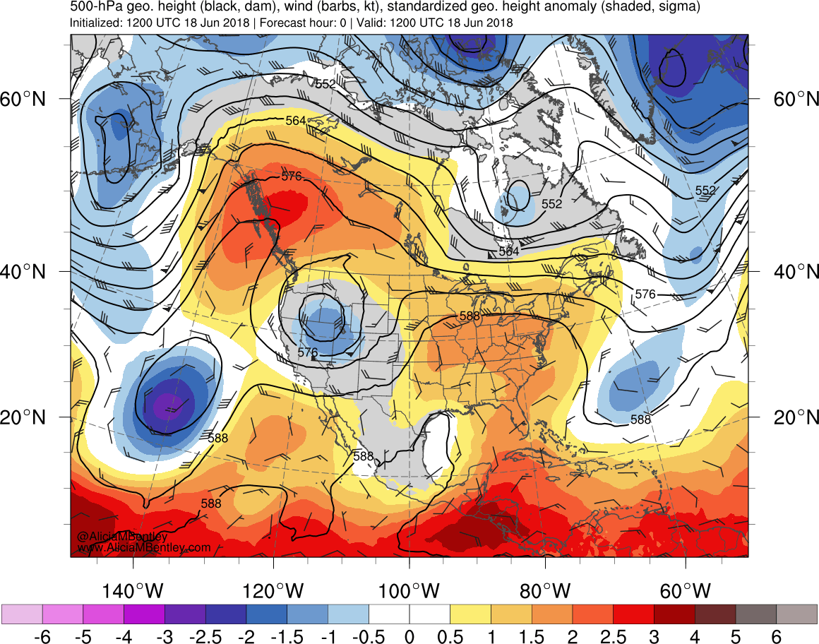
500 hPa Standardized Geostrophic Height Anomalies. Image courtesy Dr. Alicia Bentley
An upper level low over the western Gulf of Mexico and an upper level ridge centered over the southeastern United States resulted in sustained moisture transport across southeast Texas and southwest Louisiana from 17 - 21 June. Precipitable water values increased to around 2.2", a +2.5 to +3 sigma standardized anomaly.
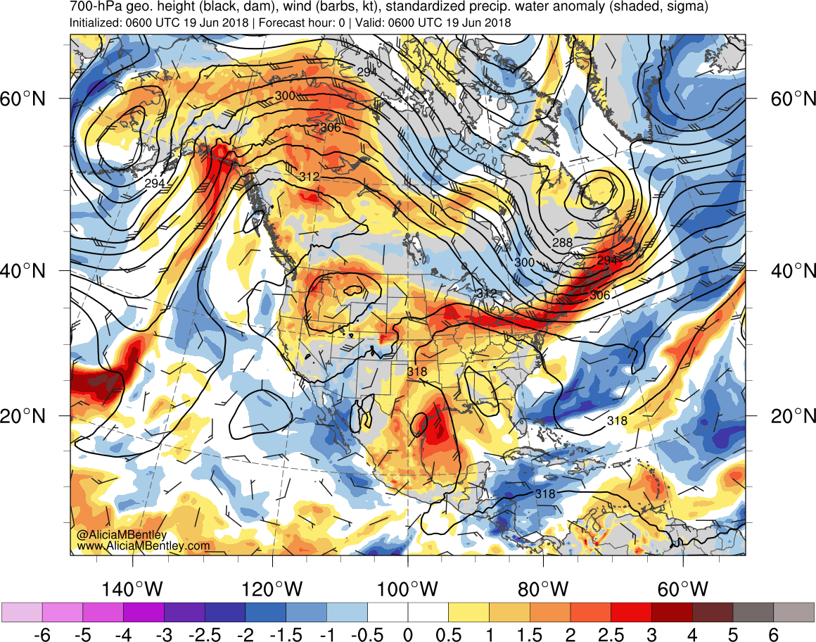
Precipitable Water Anomalies. Image courtesy Dr. Alicia Bentley
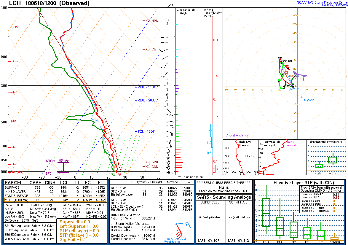
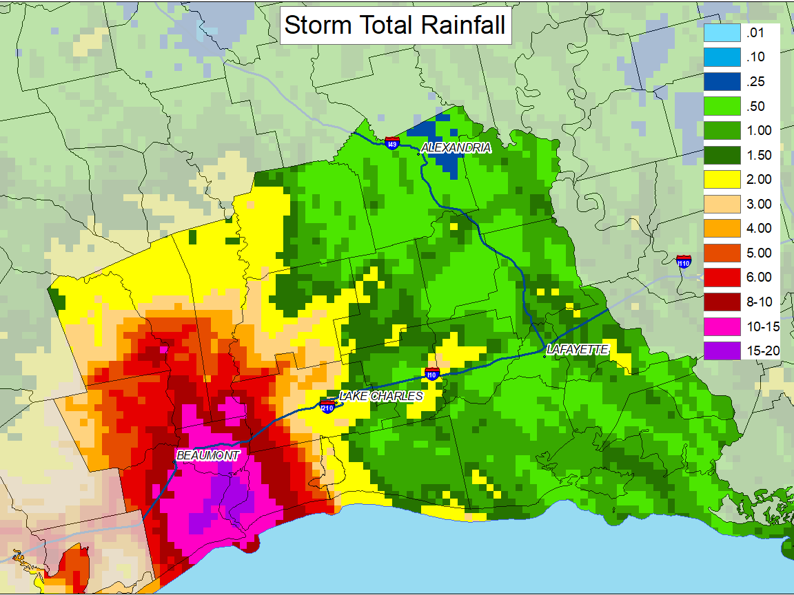
The 18 June 12Z KLCH sounding displayed a tall and skinny CAPE profile with a freezing level over 15000 feet. The deep warm cloud layer indicated an atmosphere favorable for convection capable of high precipitation efficiency. Several bands of convection developed and trained over portions of southeast Texas and southwest Louisiana resulting in very heavy rainfall, in excess of 10" in spots, and flash flooding.
 |
17-21 June 2018 Rainfall Totals |
||
 |
||
|
While the following rainfall totals are from 17-21 June, many of the listed locations had the majority of the precipitation fall within a 48 hour period. Observations are collected from a variety of sources with varying equipment and exposures. Not all data listed are considered official. We thank all volunteer weather observers for their dedication. |
||
| Location | Total | Source |
| Port Arthur 5 SW | 15.31" | ALERT Gauge |
| Bridge City 1.3 NW | 14.59" | CoCoRaHS |
| Sabine Pass 10 NW | 14.45" | ALERT Gauge |
| Sabine Pass 12 WNW | 14.45" | ALERT Gauge |
| Sabine Pass 9 WSW | 14.02" | ALERT Gauge |
| Beaumont-Port Arthur | 13.29" | ASOS |
| Vidor 7.2 N | 12.55" | CoCoRaHS |
| McFaddin RAWS | 12.41" | RAWS |
| Sabine Pass 12 WSW | 11.81" | ALERT Gauge |
| Central Gardens 5 NW | 11.46" | ALERT Gauge |
| Hamshire 11 SE | 10.83" | ALERT Gauge |
| Port Arthur 18 WSW | 10.75" | ALERT Gauge |
| Beaumont City | 10.67" | COOP |
| Beaumont 3.3 SW | 10.64" | CoCoRaHS |
| Beaumont 4 SW | 10.36" | ALERT Gauge |
| Fannet 6 NE | 10.35" | ALERT Gauge |
| Port Arthur City | 10.33" | COOP |
| Fannet 2 SW | 10.11" | ALERT Gauge |
| Nederland 7 WSW | 9.92" | ALERT Gauge |
| Beaumont 4 S | 9.69" | ALERT Gauge |
| Beaumont 2 SW | 9.68" | ALERT Gauge |
| Beaumont 1 ENE | 9.65" | ALERT Gauge |
| Beaumont 4 WSW | 9.56" | ALERT Gauge |
| Lumberton | 9.41" | COOP |
| Beaumont 1 NE | 9.29" | ALERT Gauge |
| Sabine Pass 8 NW | 9.17" | ALERT Gauge |
| Fannett 6 SE | 9.13" | ALERT Gauge |
| Beaumont 2 W | 9.05" | ALERT Gauge |
| Fannett 1 NE | 9.01" | ALERT Gauge |
| Beaumont 3 NE | 9.01" | ALERT Gauge |
| Sabine Pass 18 WSW | 8.98" | ALERT Gauge |
| Beaumont 2 SE | 8.86" | ALERT Gauge |
| Beaumont 1 NW | 8.82" | ALERT Gauge |
| Bevil Oaks 5 ENE | 8.74" | ALERT Gauge |
| Orange 9 N | 8.68" | COOP |
| Beaumont 1.8 SW | 8.41" | CoCoRaHS |
| Beaumont 4 NNW | 8.27" | ALERT Gauge |
| Beaumont 2 NNW | 8.12" | ALERT Gauge |
| Bevil Oaks 4 E | 8.11" | ALERT Gauge |
| Port Arthur 9 WSW | 8.03" | ALERT Gauge |
| Beaumont Research Center | 7.97" | COOP |
| Fannett 5 WNW | 7.92" | ALERT Gauge |
| China 17 SSE | 7.92" | ALERT Gauge |
| China 5 ESE | 7.79" | ALERT Gauge |
| China 2 S | 7.72" | ALERT Gauge |
| Beaumont 5 SW | 7.68" | ALERT Gauge |
| China 2 E | 7.25" | ALERT Gauge |
| Bevil Oaks 2 SE | 6.97" | ALERT Gauge |
| Hamshire 5 SSW | 6.97" | ALERT Gauge |
| Port Arthur 12 SW | 6.96" | ALERT Gauge |
| Kountze 0.0 WSW | 6.43" | CoCoRaHS |
| Lake Charles 7 NW | 5.81" | COOP |
| Kirbyville 1.5 SE | 5.43" | CoCoRaHS |
| Nome 4 NE | 5.40" | ALERT Gauge |
| Nome 6 S | 4.96" | ALERT Gauge |
| Warren RAWS | 4.89" | RAWS |
| Sour Lake 4.89 NNE | 4.61" | ALERT Gauge |
| Hackberry 8 SSW | 4.60" | COOP |
| Town Bluff Dam | 4.52" | COOP |
| Moss Bluff 2 NNW | 4.43" | COOP |
| Thicket 4 SE | 4.05" | ALERT Gauge |


 Follow us on YouTube