 Photos of High Water and Flooding on the Rio Grande and Associated Floodways. Photos courtesy of Starr County Emergency Management and Hidalgo County Emergency Management |
|
| Major Rio Grande Flooding in Starr, Hidalgo July 2010 Several Feet of Rain from Alex in Mexico Sets Dam Releases in Motion |
|
|
|
|
|
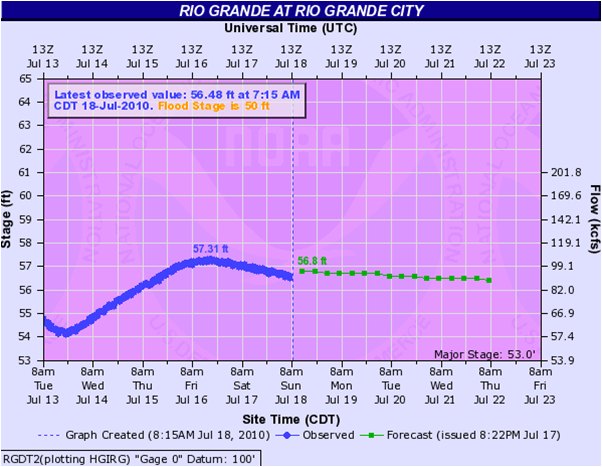
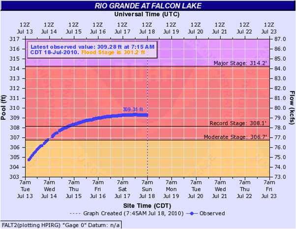
The Story Releases of water from reservoirs behind dams on both sides of the border began soon after the heaviest rains from Alex ended. On July 4th, releases began at the Marte R. Gomez Reservoir, flowing into Mexican Floodways but also toward the Rio Grande bordering Starr and western Hidalgo County. On July 5th, water levels had increased sufficiently at Amistad Dam, located much farther upstream near Del Rio, Texas, to begin releases down the river. By the 7th, with waters from Amistad having created major flooding in and near Laredo, Falcon Reservoir, located along the Rio Grande including Starr and Zapata County, began releasing water. The initial rate of 15,000 cubic feet per second (cfs) was initially within capacity of the United States side of the flood control system, and the expectation for a potentially critical flood area between Falcon and Anzalduas Reservoir just upstream from Mission (Hidalgo County) was high water, but little if any flooding. That would quickly change on July 8th, when releases from Falcon Dam were more than doubled to 39,700 cfs (1125 cubic meters per second, cms). Soon after, the river surged to major flood levels in Starr and extreme western Hidalgo County, where the river widened significantly and flooded rangeland, as well as several small communities along its banks, during the weekend of July 10th and 11th. By July 14th, outflow from Falcon Dam was raised to 60,000 cfs (1700 cms) in order to relieve pressure on the dam from the reservoir pool, which had risen steadily above flood stage of 301.2 feet during the morning of July 12th . This release rate would continue until July 27th, followed by gradually reduced rates over the next several days. By August 2nd, releases were brought down to 30,000 cfs. Heating and drying of the atmosphere from late July through mid August shut down any potential for significant rainfall across the Rio Grande Valley and Sierra Madre, allowing the entire Rio Grande watershed and flood control system to finally drain out. By mid August, nearly all forecast points were below action stage, the Lower Rio Grande Valley Flood Control Project (floodways) were receding steadily, and releases from United States and Mexican reservoirs were stable. At Falcon International Reservoir, the pool level rose well above flood stage, peaking at a new record stage of 309.31 feet during the evening of July 17th (below right). The continued high pool level required maintaining releases of 60,000 cubic feet per second for nearly 14 consecutive days, in order to maintain a manageable water level at the dam. At Falcon, the previous record of 308.1 feet (set in October, 1958) was not only broken, but the pool level remained above the prior record for nearly 7 full days, from around 130 AM CDT on July 15th through 930 PM on July 22nd. The image below shows the Rio Grande City Gaging site, and the Falcon Dam Pool level as of early July 18th. The pool level was in flood from late morning of July 14th through 4 PM on August 13th, nearly 31 consecutive days! For current information on Rio Grande information – flood or not – surf to our Advanced Hydrological Prediction Service web page. Impacts The city of La Grulla was under mandatory evacuation by July 16th as increasing water levels and currents threatened more of the community than earlier in the week. As a precautionary measure in the city of Roma, three small subdivisions located in the low lying areas and along the bank just south of the Port of Entry are under a mandatory evacuation. These include De La Cruz sub-division about (20 to 25 homes), Campo Verde (4 homes), and Garza sub-division (1 home). By July 22nd, the flooding in Starr County had impacted 178 homes/businesses, including 65 in La Grulla and 39 in Roma. 166 families required temporary housing. Preliminary damages to highways and bridges in Starr County was at $19 million; public and private property estimates were underway through the weekend of July 23rd and 24th. Agricultural damage is also expected to be significant in Starr County alone. In Hidalgo County, mandatory evacuations were initiated on July 12th for the community of Los Ebanos, in the southwest corner of the County; the evacuation level was reduced to voluntary on July 20th. The early evacuations proved fateful, as pressure on a retention pond dike caused it to rupture, spilling water into some neighborhoods and forcing most residents to leave the area. Additional impacts were noted between Los Ebanos and the Anzalduas Diversion Dam, where several residences and roadways were threatened prior to the levee south of Mission. Farther downstream, The Lower Rio Grande Valley Flood Control Project, including Anzalduas Diversion Dam and the series of floodways (spillways) on both sides of the border were activated. However, between the Anzalduas Diversion Dam and the Retamal Dam, where spillway control begins in earnest, several structures and land inside the levee were flooded, including much of Santa Ana National Wildlife Refuge south of Pharr. With rainfall over, the spillways were doing their job as of this writing; gaging locations at San Benito and Brownsville were being held at Action Stage (below minor flood stage). Initial aerial surveys conducted on July 9th indicated that for Hidalgo County south of the Anzalduas Dam, water was contained well within the spillway structure, while the same could not be said for the Mexican side of the river. During the latter half of July and into early August, the Lower Rio Grande Flood Control Project Floodways (Banker, Main, and North) were generally at half capacity, meaning water levels were several feet high but sufficiently below the height of the levee system. Visual and measured levels generally ranged from 4 to 8 feet across the system, which begins at Anzalduas Diversion Dam and stretches east just south of McAllen and Pharr toward Progreso Lakes, curving north between Weslaco and Mercedes (after a split with the Arroyo Colorado), then turning east at La Villa before entering extreme northern Cameron County, passing between Combes and Sebastian before entering rural southern Willacy County. The floodway ends in the salt flats along the Laguna Madre, just north of the Arroyo Colorado. On August 3rd, President Obama declared most counties in the Rio Grande Valley a Major Disaster, eligible for federal funding to assist with the longer term recovery. Deep South Texas Counties included Cameron, Hidalgo, Starr, Zapata, and Jim Hogg. Property and Crop damages from the flood will ultimately total well over $100 million when all assessments are completed later in August and likely into September. As of July 29th, property damage estimates in Starr and Hidalgo County had reached $40 million; additional property damage values had not been received from Zapata County. A sizeable portion of the $44 million cotton crop will also be affected when harvests are completed. As of this writing, no fatalities had been directly attributed to the flood waters themselves; however, a man was found dead in the Main Floodway south of Pharr on August 4th but causes were unknown as of this writing. Updated damage estimates will be provided in this article as the information is received. For a photo gallery of aerial survey pictures from Hidalgo County Emergency Management, many taken between July 9th and 13th, click here. For a supplemental gallery, including photos taken through July 22nd, click here For dozens of aerial photographs taken over the Lower Rio Grande Valley Floodway, taken July 19th, click here. This article will be updated by early September to include more recent damage estimates and additional photos or links. |
|
 |
 |

