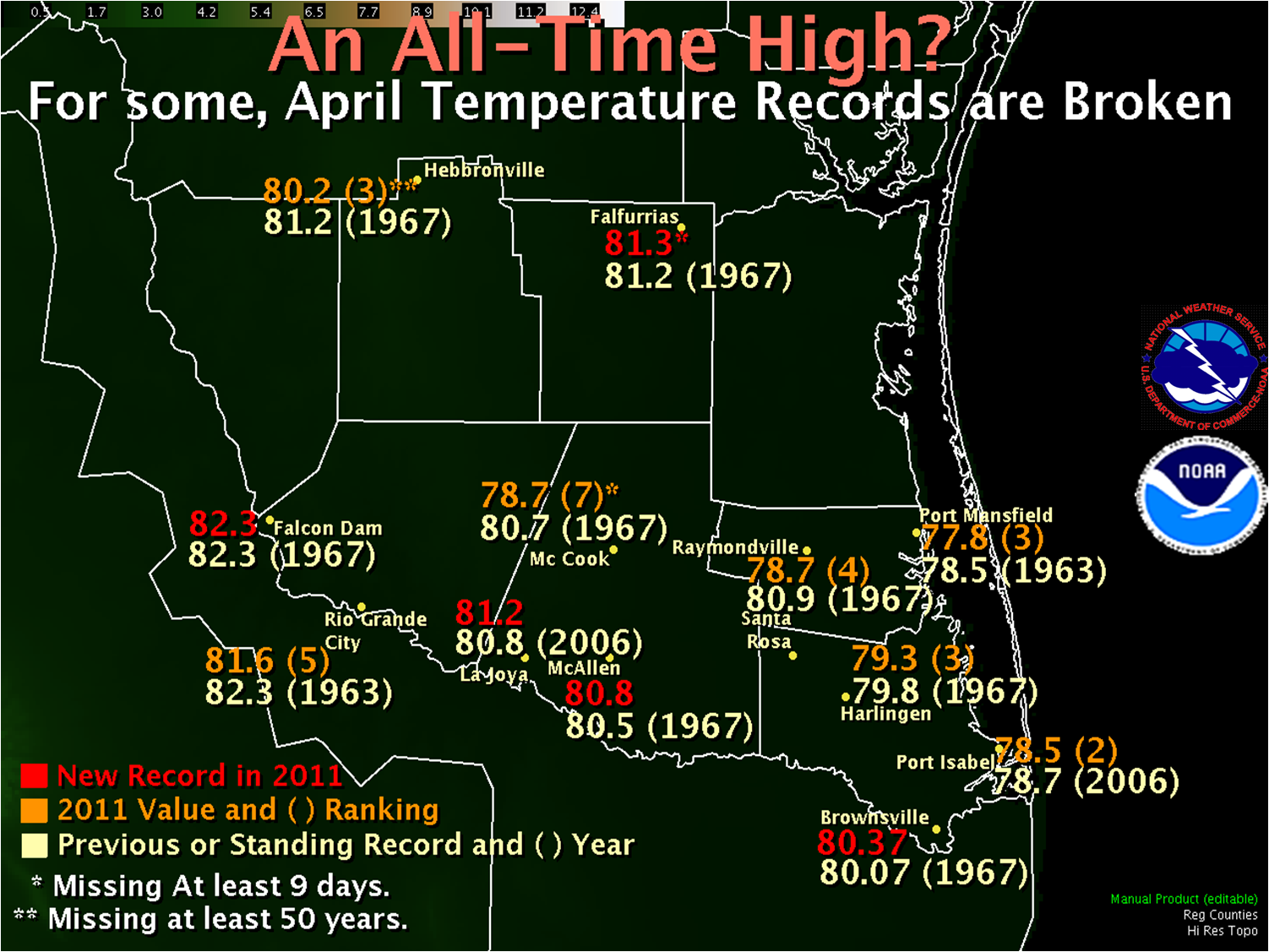
 April 2011 Average temperatures (maximum plus minimum divided by 2, per day) for April 2011 (top number) and prior or continuing all time (bottom number). Harlingen and McAllen are based on Cooperative locations, not nearby airports. Brownsville’s breaker is the highest since records began in 1878! |
||||||||||||||||||||||||||||||||||||||||||||||||||||||||||||||||||||
| July in April: 2011 Breaks Records Hottest Month in Many areas Replaces 1967 Benchmark |
||||||||||||||||||||||||||||||||||||||||||||||||||||||||||||||||||||
|
April 2011 was seriously hot. And windy. And, for the Lower and Mid Valley, unusually humid. Unfortunately, the heat and humidity at the eart’s surface did not translate into any rainfall, as the entire region was rain free, save for a few sprinkles across the upper Valley/Rio Grande Plains from decaying activity sliding east of the Sierra Madre Oriental. Drought and Wildfire Growth Potential continued to worsen through the month; by month’s end, the Valley had reached Extreme Drought conditions, with the King Ranch at Severe Drought levels. Dozens, if not more than 100, brush and grass fires broke out through the month across the region. Fortunately, the vast majority were small and contained/controlled rather quickly. At least two grew to more than 100 acres, and others caused some damage to structures. Four days were notable for the combination of desert–like "blast furnace" heat, each associated with rapid heating and drying forced by compressed air moving from higher terrain of West Texas and northern Mexico to the lower elevations of the Rio Grande Valley and South Texas Plains. On April 4th, 11th, 15th, and 27th, temperatures soared well into the 90s and lower 100s, afternoon humidity crashed below 10 percent along and west of Highway 281, and north winds gusted in excess of 30 mph. At most other times, the Valley’s Ceaseless Wind pattern of persistent gusty winds from the south or southeast was common, with little break. The sharpening difference between the hot, dry ground and much slower warming of the western Gulf contributed to the intensity of the wind machine. The machine peaked as the month closed, with relatively deep surface low pressure developing across the Rio Grande Plains for the 30th and May 1st. Peak gusts are shown in the table below; most gusts were recorded during the late morning and early afternoon each day. The gusty winds created a driving hazard along State Highway 48 between the Port of Brownsville and Port Isabel, and along State Highway 100 between Port Isabel and several miles east of Los Fresnos, each day. Blowing sand reduced ground visibility below one half mile along much of the route along State Highway 48. The gusty winds may have contributed to removal of building cladding at a nightclub along FM 802 (Ruben Torres Boulevard) in Brownsville during the early afternoon of April 30th.
*20 foot wind speed. Remainder are 10 meter wind speeds.
|
||||||||||||||||||||||||||||||||||||||||||||||||||||||||||||||||||||
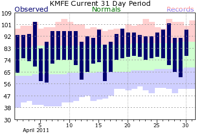 Temperature trends at McAllen/Miller Airport, April, 2011. Note that nearly all bars stretch into the red, or above average space, and the number of times 92°F is reached (two thirds of the time). Temperatures passed the century mark twice (4th and 27th). |
||||||||||||||||||||||||||||||||||||||||||||||||||||||||||||||||||||

