National Weather Service United States Department of Commerce


Rainfall finally reaches Deep South Texas after two months on May 12th, 2011 (click to enlarge)
First Notable Rain In More than Sixty Days!
Squall line, other storms also bring Wind and some Hail
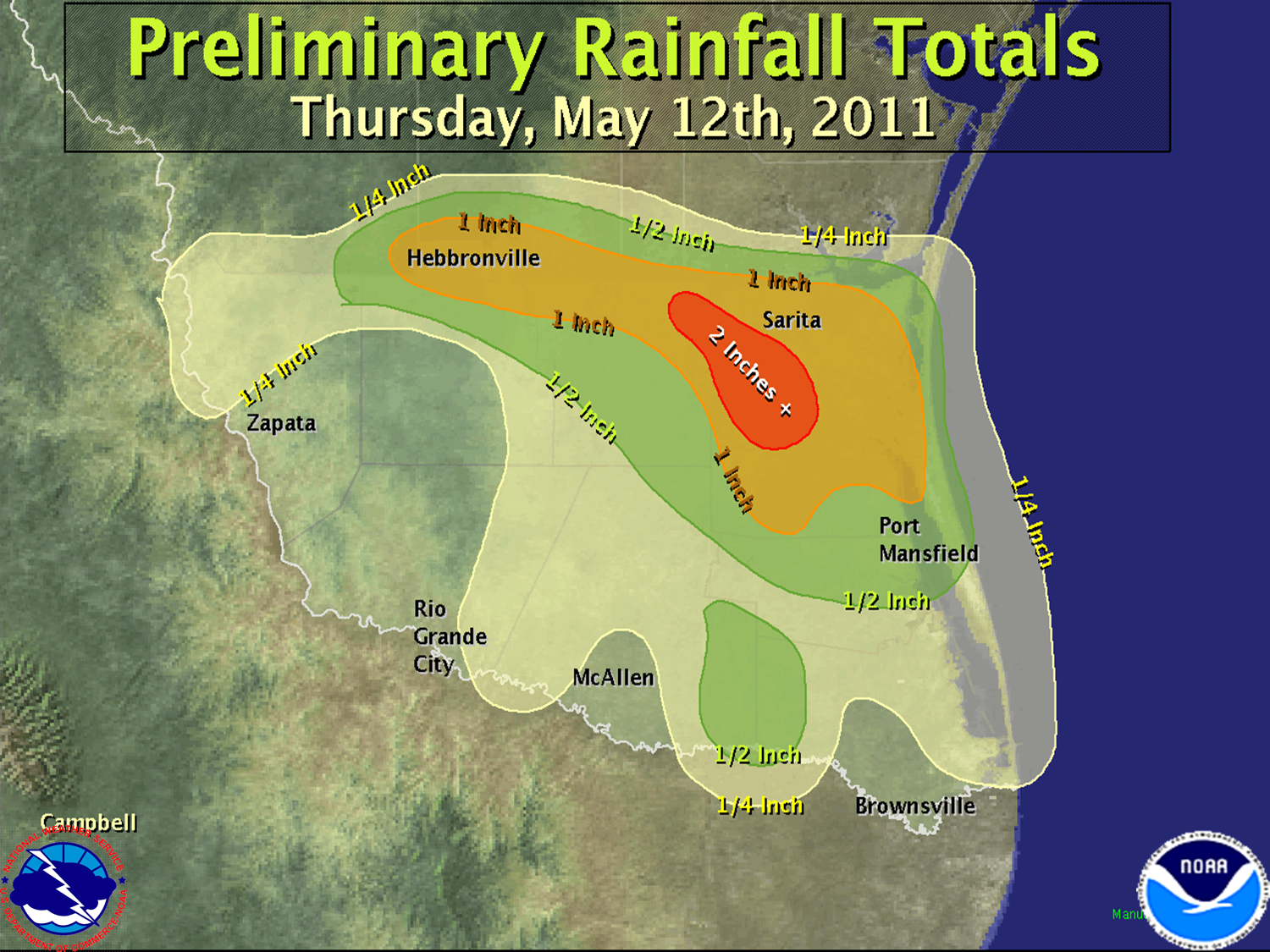
Quick Event Wrap
An upper level disturbance acted on increasingly unstable atmosphere to create a system of thunderstorms across the Big Bend early on the 12th. Favorable atmospheric conditions and mid level wind fields turned the pre dawn system into a squall line, which pushed south and east into the South Texas Plains before noon, then across the Brush Country and King Ranch during the afternoon of the 12th. Outflows from the line further developed precipitation into the Rio Grande Valley, with the first widespread rains across most areas since March 6th. Unfortunately, areas needing the rain most (those in Exceptional Drought) received less than a quarter inch, and in some cases missed the rains completely. Heavier rains produced urban flooding in Falfurrias, wind gusts to 45 mph or higher from Brooks to Kenedy County, and dangerous lightning, gale force winds, and rough seas for boaters in Laguna Madre and the Lower Texas Gulf coast by late afternoon.

The welcome rains were still no match for severe to exceptional drought, but were manna from heaven for homeowners with stressed plants, even those that are relatively drought resistant. The following statement summarizes the Rainfall on May 12th:


000
NOUS44 KBRO 131550
PNSBRO
TXZ248>257-132100-
 
PUBLIC INFORMATION STATEMENT
NATIONAL WEATHER SERVICE BROWNSVILLE TX
1045 AM CDT FRI MAY 13 2011
 
...FIRST SIGNIFICANT RAIN AFFECTS DEEP SOUTH TEXAS SINCE MARCH...
 
 
AIRPORTS/ASOS/AWOS/RAWS
============================
LINN-SAN MANUEL         0.06 INCHES
HEBBRONVILLE            1.06
ZAPATA                  0.10
BROWNSVILLE             TRACE
LAGUNA ATASCOSA         0.08
EDINBURG                0.36
HARLINGEN               TRACE
MCALLEN                 0.04
SANTA ANA               0.18
WESLACO                 0.21
FALFURRIAS              0.25
 
 
NWS COOPERATIVE OBSERVERS
============================
HARLINGEN               0.05 INCHES
ESCOBAS                 0.05
EDINBURG                0.12
HEBBRONVILLE            1.00
MCALLEN                 0.15
PORT MANSFIELD          0.44
SANTA ROSA              0.31
SARITA                  1.60
 
 
COCORAHS/HYDROLOGIC GAGES/MISC
===============================
FALFURRIAS               1.50 INCHES
SAN PERLITA 19.1 NNW     1.10 
EDINBURG 1.1 WSW         0.48
ALAMO 1.5 NNE            0.42
HARLINGEN 4.3 WSW        0.21
PALM VALLEY 2.2 SSW      0.10
LOS FRESNOS 0.3 NE       0.09
MISSION 1.9 ENE          0.02
RANCHO VIEJO 0.7 E       0.02
BROWNSVILLE 2.2 W        0.02
BROWNSVILLE 6.4 SE       TRACE