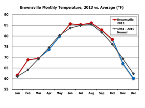
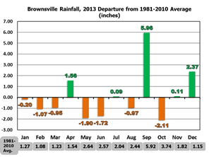
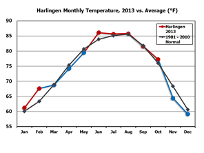
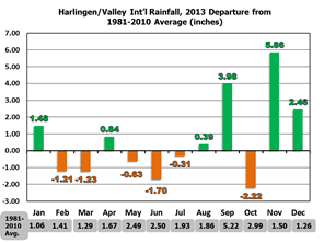
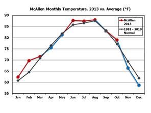
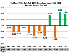
| Temperature and Precipitation Trends Brownsville, Harlingen, McAllen, in 2013 Warm, Dry weather dominated the first half of 2013, but the year would close on a hopeful note, with noticeably cooler streaks combined with substantial rainfall that quenched at least short term water thirst for much of the Rio Grande Valley. The charts below show monthly temperature averages (left, line charts) and precipitation departures from the 1981–2010 average (right, bar charts) through the year. Averages and departures are based on the data sample of record, which dates back to 1878 for Brownsville, 1953 for Harlingen (Valley Airport), and 1961 for McAllen (Miller Airport). Most months were near or above the long term average for temperature through October, though the departures were notably less than for 2012 and 2011. January and February 2013 picked up where the record warm 2012 ended, with much above normal temperatures. Spring would see temperatures settle near or even slightly below the 30 year average, before June surged hot. The remainder of summer and early autumn remained slightly above average, but any chance for 2013 to follow in 2012’s (and 2011’s) footsteps was crushed by the most significant negative departure from normal since February and March, 2010. Still, the year end rankings were among the top 25% warmest on record, despite the late year cooldown. Notable were the departures from average precipitation to close out the year; September’s tropical moisture pushed totals above average at many locations near the Rio Grande, including pockets with more than a foot of rain. November and December dumped non tropical but very welcome soaking rains to the region; some locations in Cameron County saw more than 10 inches between the 22nd of November and the end of the year. The latter half of 2013’s rainfall ensured that locations in the Lower Valley ranked near the middle of the long term record; still, McAllen/Miller, which continued to fall woefully short of average until September, only fell to 9th driest after helpful rains of November and December. The helpful rainfall across the Rio Grande Valley and through portions of the Lower Rio Grande basin in late July and again in September helped bring reservoir levels at the end of 2013 back to or just above those of 2012. While this was good news given the alternative (another dry year with potential for widespread public water emergencies), there is a long way to go to reach stability for agricultural and municipal needs in 2014 as of this writing. |
|
 |
 |
 |
 |
 |
 |