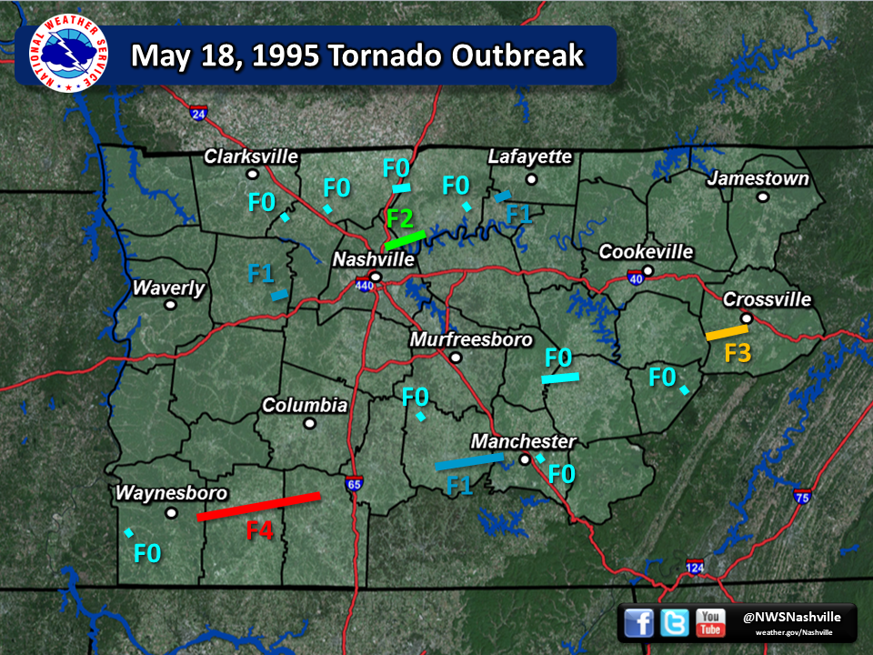
| May 18, 1995 Tornado Outbreak | ||||||||
| # | Counties | Rating | Time (CST) | Length (miles) | Width (yards) | Fatalities | Injuries | |
| 1 | Dickson | F1 | 1058 | 1.0 | 50 | 0 | 0 | |
| 2 | Davidson/Sumner | F2 | 1130 | 6.0 | 75 | 0 | 28 | |
| 3 | Sumner | F0 | 1145 | 0.75 | 50 | 0 | 0 | |
| 4 | Trousdale/Macon | F1 | 1151 | 3.0 | 50 | 0 | 0 | |
| 5 | Wayne | F0 | 1515 | 0.5 | 10 | 0 | 0 | |
| 6 | Wayne/Lawrence/Giles | F4 | 1552 | 29.0 | 1000 | 3 | 33 | |
| 7 | Bedford | F0 | 1555 | 0.5 | 25 | 0 | 0 | |
| 8 | Warren/Cannon | F0 | 1622 | 5.0 | 25 | 0 | 0 | |
| 9 | Cheatham | F0 | 1650 | 0.5 | 10 | 0 | 0 | |
| 10 | Bedford/Coffee | F1 | 1700 | 16.0 | 50 | 0 | 0 | |
| 11 | Cumberland | F3 | 1710 | 10.0 | 1000 | 0 | 20 | |
| 12 | Robertson | F0 | 1715 | 0.5 | 10 | 0 | 0 | |
| 13 | Robertson/Sumner | F0 | 1724 | 3.0 | 25 | 0 | 0 | |
| 14 | Coffee | F0 | 1730 | 1.0 | 20 | 0 | 0 | |
| 15 | Van Buren | F0 | 1815 | 0.1 | 10 | 0 | 0 | |
| Reports & Outlooks | |||
| SPC Storm Reports |
| F1 Dickson County Tornado | |
| Counties: | Dickson |
| Time: | 10:58 AM CST |
| EF Scale: | F1 |
| Damage Path Length: | 1.0 miles |
| Damage Path Width: | 50 yards |
| Fatalities: | 0 |
| Injuries | 0 |
|
Damage: |
|
| F2 Davidson/Sumner County Tornado | |
| Counties: | Davidson/Sumner |
| Time: | 11:30 AM CST |
| EF Scale: | F2 |
| Damage Path Length: | 6 miles |
| Damage Path Width: | 75 yards |
| Fatalities: | 0 |
| Injuries | 28 |
| Damage: STORM DATA: The tornado first touched down near Goodlettsville and moved northeast. The tornado struck near the Rivergate Mall. At least two dozen business were damaged. Nearly 500 cars were damaged beyond repair at a nearby auto dealership. In Sumner County, 35 apartments were destroyed along with three mobile homes. Several business were damaged. An elementary school in Westmoreland lost a large area of roofing above the gymnasium. The Gallatin Civic Center suffered major damage to its swimming pool. Several high tension towers were bent. Numerous trees and power lines were knocked down. GRAZULIS: The tornado moved northeast from near Goodlettsville. It struck the Rivergate Mall, damaging at least two dozen businesses. Most of the injuries were at the mall, and included broken hands and severe cuts as part of the mall roof collapsed. Nearly 500 cars were damaged beyond repair at a nearby auto dealership. A total of 35 apartments were destroyed, as were three mobile homes. Several other businesses were damaged. An elementary school in Westmoreland lost a large area of roofing above the gymnasium. SHAMBURGER (2019): No NWS storm survey was conducted for this major F2 tornado. NCDC and Storm Data also erroneously omit the Davidson County portion of this tornado (which Goodlettsville and Rivergate Mall are located in) and Davidson County was added to this entry. In addition, the path length is listed at 5 miles by both Storm Data and Grazulis, yet both narratives describe a sharp V-shaped path of at least 30 miles as the Gallatin Civic Center is located 17 miles east-northeast of Goodlettsville and Westmoreland is over 30 miles to the northeast. A continuous path from Rivergate Mall to the Gallatin Civic Center to Westmoreland would pass through highly populated areas, and it seems very unlikely more damage and injuries would not have resulted. In fact, the Gallatin News-Examiner newspaper does not mention any damage between Hendersonville and Gallatin, nor between Gallatin and Westmoreland. OHX radar data is not available prior to 11:47 am for the Goodlettsville to Gallatin area, but it is available for the Westmoreland area which indicates that the damage to the schools in that area could not have been from the same circulation that affected Rivergate Mall, and in fact was almost certainly from severe downburst winds and not a tornado. Based on all of this, the damage around the Gallatin Civic Center in northeast Gallatin is listed here as a brief separate F0 tornado. The Goodlettsville to Hendersonville tornado path was also extended slightly to 6 miles based on the damage reports in the Gallatin News-Examiner indicating the tornado tracked from Rivergate Mall to the Highway 31 and Center Point Road intersection, then into Hendersonville across Monthaven Park, the Hickory Run and Arbors Apartments, the MGM warehouse on Free Hill Road, Gloryland Baptist Church on Forest Retreat Road, through the Hendersonville Mobile Home Park on Iris Drive, and across Old Shackle Island Road. Other damage reported throughout Sumner County is too weak and scattered to determine if other tornadoes occurred. |
|
| F0 Sumner County (Gallatin) Tornado | |
| Counties: | Sumner |
| Time: | 11:45 AM CST |
| EF Scale: | F0 |
| Damage Path Length: | 0.75 miles |
| Damage Path Width: | 50 yards |
| Fatalities: | 0 |
| Injuries | 0 |
| Damage: STORM DATA: The tornado first touched down near Goodlettsville and moved northeast. The tornado struck near the Rivergate Mall. At least two dozen business were damaged. Nearly 500 cars were damaged beyond repair at a nearby auto dealership. In Sumner County, 35 apartments were destroyed along with three mobile homes. Several business were damaged. An elementary school in Westmoreland lost a large area of roofing above the gymnasium. The Gallatin Civic Center suffered major damage to its swimming pool. Several high tension towers were bent. Numerous trees and power lines were knocked down. GRAZULIS: The tornado moved northeast from near Goodlettsville. It struck the Rivergate Mall, damaging at least two dozen businesses. Most of the injuries were at the mall, and included broken hands and severe cuts as part of the mall roof collapsed. Nearly 500 cars were damaged beyond repair at a nearby auto dealership. A total of 35 apartments were destroyed, as were three mobile homes. Several other businesses were damaged. An elementary school in Westmoreland lost a large area of roofing above the gymnasium. SHAMBURGER (2019): No NWS storm survey was conducted for this damage. Originally included in Storm Data and by Grazulis as part of the tornado that hit Rivergate Mall and Gallatin, this damage was clearly caused by a separate tornado as the mall is located over 15 miles west of Gallatin. Damage reports in the Gallatin News Examiner newspaper suggest this was a brief, weak tornado that touched down in northeast Gallatin along North Water Street, then moved northeast across Eastover Drive, through the Gallatin Municipal Park, and then damaged the Gallatin Civic Center. The path length, path width, location, and F-Scale rating have all been estimated based on the newspaper reports and photos. |
|
| F1 Trousdale/Macon County Tornado | |
| Counties: | Trousdale/Macon |
| Time: | 11:51 AM CST |
| EF Scale: | F1 |
| Damage Path Length: | 3.0 miles |
| Damage Path Width: | 50 yards |
| Fatalities: | 0 |
| Injuries | 0 |
| Damage: STORM DATA: A tornado touched down near the town of Green Grove. One barn was blown entirely on the roadway while another barn was blown down. Several homes were damaged. Eighty tombstones were destroyed. Numerous trees were knocked down. SHAMBURGER (2015): No NWS storm survey was conducted for this tornado. However, radar data along with newspaper articles in the Hartsville Vidette and Macon County Times clearly indicate that this strong F1 tornado began in Trousdale County, damaging a home on Hawkins Branch Road just east of Shephard Hollow Lane. The tornado continued northeast into Macon County, destroying several barns and damaging homes on Green Grove Road and Pleasant Valley Road, with one barn blown into the roadway. One home at 4085 suffered some roof damage, while another home at 3848 Pleasant Valley Road had its roof completely blown off along with all windows blown out, suggesting the tornado could have reached F2 intensity. The nearby Green Grove cemetery had 80 tombstones blown over and destroyed. Based on this damage, the tornado path was increased from 1 mile to 3 miles long and width widened slightly from 25 to 50 yards. In addition, radar data indicates the tornado began slightly earlier at 1151 AM CST. |
|
| F0 Wayne County Tornado | |
| Counties: | Wayne |
| Time: | 3:15 PM CST |
| EF Scale: | EF1 |
| Damage Path Length: | 0.5 miles |
| Damage Path Width: | 10 yards |
| Fatalities: | 0 |
| Injuries | 0 |
| Damage: STORM DATA: A tornado briefly touched down in the western part of Wayne County. Only a few trees were knocked down. SHAMBURGER (2015): NCDC incorrectly lists this tornado as occurring in the eastern part of Wayne County, not the western part, and the location and time were corrected based on radar data. |
|
| F4 Wayne/Lawrence/Giles County Tornado | |
| Counties: | Wayne/Lawrence/Giles |
| Time: | 3:52 PM CST |
| EF Scale: | F4 |
| Damage Path Length: | 29.0 miles |
| Damage Path Width: | 1000 yards |
| Fatalities: | 3 |
| Injuries | 33 |
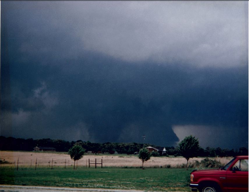
| Damage: STORM DATA (Lawrence County): The tornado touched down near the Lawrence/Wayne County line near Deerfield and lifted near Campbellsville in Giles County. Two people were killed while outside their trailer in the extreme western part of Lawrence County and a third person was killed while inside a house near Deerfield. Thirty-four houses, 16 mobile homes and one business were destroyed. Ninety-eight houses, three mobile homes and two other buildings were damaged. The tornado pulled corn stalks that were two feet tall out fo the ground and destroyed 6 TVA steel high-tension-wire towers. Three of these towers were never found. A cancelled check from Ethridge was found in Cannon County, some 90 miles away. Seventy-five to 100 people were evacuated in Ethridge because of downed power lines. STORM DATA (Giles County): Over 40 building suffered structural damage to them. A few trees were knocked down. A man was injured in Liberty Hill as he sought shelter in his camp trailer. Eight power poles were blown down. SHAMBURGER (2023) - High resolution satellite imagery and radar data indicate this tornado actually began in far eastern Wayne County just east of the Natchez Trace Parkway where numerous trees were blown down, then moved east-northeastward through the Deerfield area in Lawrence County. Two people were killed southwest of Deerfield on Zinker Road near Piney Road. Photos from Deerfield showed a home suffered F1 damage on N Hood Road, the old Deerfield School on Waynesboro Highway had F2 damage, and a nearby mobile home was destroyed (F2). Further to the east, another person was killed on Valley Road at Ethridge Red Hill Road. A photo was taken of the large tornado from about 3 miles away on Grandmere Rd north of Grandaddy Rd looking NNW when it passed near the location of the fatality. The tornado then moved through the Ethridge area where more photos were taken of the narrowing but still intense tornado, and a video of the tornado was also taken east of Ethridge on East Edan Road looking south. Entering Giles County, the tornado weakened as it moved through Liberty Hill and Campbellsville before lifting. Based on all this, the tornado was significantly corrected from the NCDC and Storm Data records. In addition, NCDC and Storm Data incorrectly include the Giles County portion of this tornado twice, and also rate the Giles County portion as F0 despite the significant damage. Finally, the injured man in Giles County was not included in the total number of injuries for this tornado, and that injury was added into this entry. |
|
|
Tornado viewed from Grandmere Rd north of Grandaddy Rd (located 4 miles west of Lawrenceburg) looking NNW |
|
| F0 Bedford County Tornado | |
| Counties: | Bedford |
| Time: | 3:55 PM CST |
| EF Scale: | F0 |
| Damage Path Length: | 0.5 miles |
| Damage Path Width: | 25 yards |
| Fatalities: | 0 |
| Injuries | 0 |
| Damage: STORM DATA: The tornado first touched down in Eagleville where it ripped the roof off of one house and produced minor damage to a second house. The tornado skipped along and damaged three homes and one business in Rockvale. One person was injured in Eagleville and three others were injured in Rockvale. SHAMBURGER (2019): No NWS storm survey was conducted for this damage. However, radar data clearly indicates the damage in Eagleville and Rockvale was from the downburst winds in the hail core of the parent supercell, with the mesocyclone over 8 miles south of this area across northwestern Bedford County. The Shelbyville Times-Gazette newspaper does mention a possible tornado touched down in the Longview area of northwest Bedford County, but no details or damage is mentioned. Nevertheless, based on this information the tornado location was adjusted from Rutherford County to Bedford County, with the path length and width changed to short and brief due to the lack of information. Storm Data mentions 4 injuries with the damage in Eagleville and Rockvale, but one "injury" was a medical condition according to the Murfreesboro Daily News, and there is no information in any newspaper about the 3 other injuries. Therefore, the number of injuries for the tornado was adjusted to 0. passed south of Eagleville and Rockvale between 1500 and 1600 CST on this date, with the hail core passing over Eagleville and Rockvale. |
|
| F0 Cannon/Warren County Tornado | |
| Counties: | Cannon/Warren |
| Time: | 4:22 PM CST |
| EF Scale: | F0 |
| Damage Path Length: | 5.0 miles |
| Damage Path Width: | 25 yards |
| Fatalities: | 0 |
| Injuries | 0 |
| Damage: STORM DATA: The tornado first touched down in southern De Kalb County and moved southeast in the northeast part of Warren County. Several trees were knocked down, particularly in the town of Pigeon Hill in Warren County. SHAMBURGER (2015): NCDC and Storm Data both erroneously list this tornado as occurring in DeKalb County, when radar data clearly shows the tornado and parrent supercell moved from Cannon County into Warren County. In addition, NCDC incorrectly lists the time, path location and path length of this tornado, which have all been corrected based on radar data and the narrative in Storm Data. |
|
| F0 Cheatham County Tornado | |
| Counties: | Cheatham |
| Time: | 4:45 PM CST |
| EF Scale: | F0 |
| Damage Path Length: | 0.5 miles |
| Damage Path Width: | 10 yards |
| Fatalities: | 0 |
| Injuries | 0 |
| Damage: STORM DATA: A tornado briefly touched down knocking down a few trees (near Henrietta). SHAMBURGER (2015): NCDC incorrectly places this tornado in Montgomery County instead of Cheatham County, and the location was corrected accordingly. In addition, the time of this tornado was corrected based on radar data. |
|
| F1 Bedford/Coffee County Tornado | |
| Counties: | Bedford/Coffee |
| Time: | 5:00 PM CST |
| EF Scale: | F1 |
| Damage Path Length: | 16.0 miles |
| Damage Path Width: | 50 yards |
| Fatalities: | 0 |
| Injuries | 0 |
| Damage: STORM DATA: The tornado first touched down on the west side of Shelbyville. The tornado continued east and eventually hit the city of Normandy and continued into the extreme western part of Coffee County. A fire hall was destroyed in Normandy. A supermarket lost its roof in Shelbyville. Several other business sustained roof damage. Four barns at a nearby animal exhibition park were damaged. A mobile home was destroyed in Normandy. A few homes were damaged. Many trees, power poles and power lines were knocked down as well. One horse was badly injured when a tree fell on it and the horse had to be destroyed. SHAMBURGER (2019): No NWS storm survey was conducted for this damage. However, radar data clearly indicates the damage across Shelbyville was caused from downburst winds associated with the hail core of the parent supercell, while the tornado likely began around 4 miles south-southwest of Shelbyville then moved east-northeast through the Normandy area before lifting in western Coffee County. Based on radar data and the damage described in the Shelbyville Times-Gazette and Manchester Times newspapers, the path length of this tornado would be much longer than the 10 miles listed in Storm Data, and is estimated around 16 miles long. The one injury included in Storm Data was reported as occurring in the cleanup phase after the tornado according to the Manchester Times, and was not included. |
|
| F3 Cumberland County Tornado | |
| Counties: | Cumberland |
| Time: | 5:10 PM CST |
| EF Scale: | F3 |
| Damage Path Length: | 10.0 miles |
| Damage Path Width: | 1000 yards |
| Fatalities: | 0 |
| Injuries | 20 |
| Damage: STORM DATA: The tornado first touched down in the southwest part of Cumberland County and moved northeast. Two business were destroyed. Eleven homes and 14 mobiles homes were destroyed. Many other homes were damaged. One house had a gas leak in it prompting emergency management officials to evacuate a handful of nearby residents. Other homes had roof damage. Numerous trees and power lines were knocked down. GRAZULIS: The tornado first touched down in the southwest part of Cumberland County near Newton, and moved northeast to near Crossville. Eleven homes, 14 mobile homes, and two businesses were destroyed. Many other homes were damaged. SHAMBURGER (2019): No NWS storm survey was conducted for this tornado. Both Storm Data and Grazulis descriptions of this massive, major tornado are erroneous, as radar data and satellite imagery from Google Earth show this tornado began along the White/Cumberland County border west of Tarkiln Ford Road and moved east-northeast across Flat Rock Road, Old Ross Road, Meadow Park Lake and City Lake Road before lifting east of Dunbar Road around halfway between Lake Tansi and Crossville. The path of damage on satellite imagery from Google Earth is also much wider than listed by Storm Data or Grazulis, and appears to be up to 1000 yards wide near Meadow Lake Park where tens of thousands of trees were blown down. Finally, the time of the tornado was corrected based on radar data. A second F1 tornado listed in Storm Data as occurring later in the evening in the Lake Tansi area is obviously incorrect and is actually this tornado, and therefore was removed from this database. |
|
| F0 Robertson County Tornado | |
| Counties: | Robertson |
| Time: | 5:15 PM CST |
| EF Scale: | F0 |
| Damage Path Length: | 0.5 miles |
| Damage Path Width: | 10 yards |
| Fatalities: | 0 |
| Injuries | 0 |
| Damage: STORM DATA: A tornado touched down near the intersection of Interstate 24 and Highway 49. Several trees were knocked down. SHAMBURGER (2015): NCDC incorrectly lists the location of this tornado, which was corrected based on the narrative in Storm Data. |
|
| F0 Robertson/Sumner County Tornado | |
| Counties: | Robertson/Sumner |
| Time: | 5:24 PM CST |
| EF Scale: | F0 |
| Damage Path Length: | 3.0 miles |
| Damage Path Width: | 25 yards |
| Fatalities: | 0 |
| Injuries | 0 |
| Damage: STORM DATA: Several trees were blown down (from Millersville to White House). SHAMBURGER (2015): NCDC and Storm Data incorrectly list this tornado as moving north-northeast from Millersville to White House, when radar data clearly indicates this tornado began west of White House along Highway 76 in Robertson County, then moved eastward through that town before lifting northeast of White House near Highway 76 in Sumner County. In addition, radar data shows the wind damage in Millersville was clearly from downburst winds and not a tornado. The time and location of this tornado have been corrected significantly based on radar data, and Robertson County has been added to this entry. Finally, the rating for this tornado was changed to F0 from F1 as no significant damage was mentioned in Storm Data. |
|
| F0 Coffee County Tornado | |
| Counties: | Coffee |
| Time: | 5:30 PM CST |
| EF Scale: | F0 |
| Damage Path Length: | 1.0 miles |
| Damage Path Width: | 20 yards |
| Fatalities: | 0 |
| Injuries | 0 |
| Damage: STORM DATA: A house trailer was overturned. Several large trees were blown down. |
|
| F0 Van Buren County Tornado | |
| Counties: | Van Buren |
| Time: | 6:15 PM CST |
| EF Scale: | F0 |
| Damage Path Length: | 0.1 miles |
| Damage Path Width: | 10 yards |
| Fatalities: | 0 |
| Injuries | 0 |
|
Damage: SHAMBURGER (2015): NCDC incorrectly lists the time and location of this tornado, which was corrected based on radar data. |
|