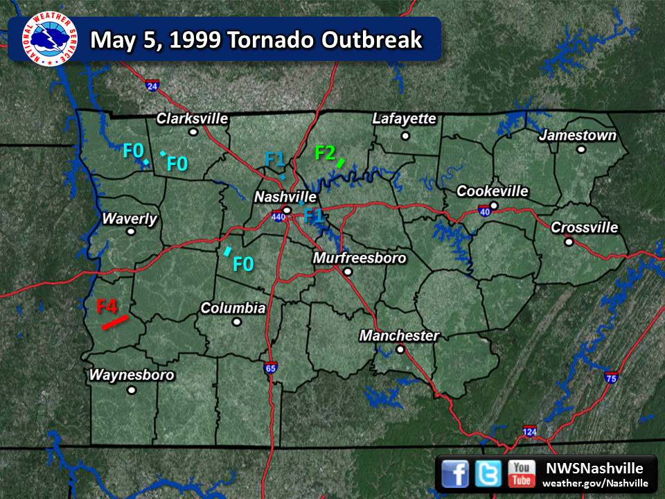
| Tornado Statistics | ||||||||
| # | Counties | Rating | Time (CST) | Length (miles) | Width (yards) | Fatalities | Injuries | |
| 1 | Stewart | F0 | 1745 | 0.50 | 100 | 0 | 0 | |
| 2 | Montgomery | F0 | 1750 | 0.50 | 100 | 0 | 0 | |
| 3 | Perry | F4 | 1924 | 6.00 | 580 | 3 | 0 | |
| 4 | Williamson | F0 | 2013 | 2.27 | 50 | 0 | 0 | |
| 5 | Davidson | F1 | 2045 | 0.10 | 100 | 0 | 0 | |
| 6 | Davidson | F1 | 2058 | 0.10 | 100 | 0 | 0 | |
| 7 | Sumner | F2 | 2136 | 0.70 | 220 | 0 | 17 | |
| Overview | |
| After two days of destructive severe weather across the southern Plains on May 3-4, 1999, the same storm system spawned a powerful QLCS (Quasi-Linear Convective System), also known as a squall line, that moved across the region during the evening hours on May 5, 1999 into the early morning hours on May 6, 1999. This QLCS produced at least 7 tornadoes across Middle Tennessee, along with widespread wind damage and hail. Based on Storm Data and available radar data, several other weak (EF0-EF1) tornadoes almost certainly touched down other than those listed below, including likely tornadoes in Hickman County, southern Dickson County, Robertson County, and northern Williamson County. Data on this tornado outbreak was gathered from local storm reports, NWS storm surveys, radar imagery from OHX and HTX radars, satellite imagery available in Google Earth, and additional research conducted in 2015 and 2016 by Sam Shamburger, a lead forecaster at NWS Nashville. Note that OHX radar data is unavailable after 8:23 PM CST through the rest of the event due to a power outage. |
| Reports & Data | ||
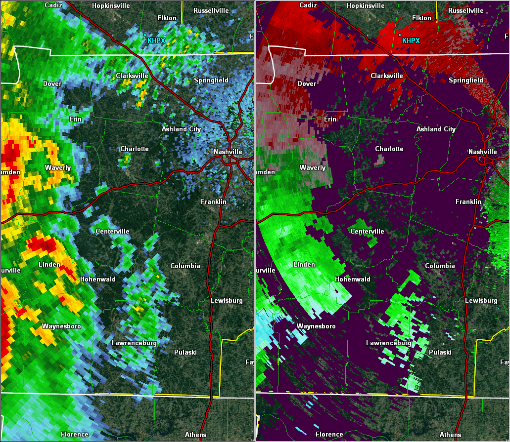
| SPC Storm Reports | OHX Radar Loop 700 PM - 823 PM CDT | May 1999 Storm Data |
| F0 Stewart County Tornado | |
| Counties: | Stewart |
| Time: | 5:45 PM CST |
| EF Scale: | F0 |
| Damage Path Length: | 0.5 miles |
| Damage Path Width: | 100 yards |
| Fatalities: | 0 |
| Injuries | 0 |
| Damage: STORM DATA: Tornado reported by local law enforcement near Highway 149. |
|
| F0 Montgomery County Tornado | |
| Counties: | Montgomery |
| Time: | 5:50 PM CST |
| EF Scale: | F0 |
| Damage Path Length: | 0.5 miles |
| Damage Path Width: | 100 yards |
| Fatalities: | 0 |
| Injuries | 0 |
| Damage: STORM DATA: Spotter reported tornado near Highway 149 in Montgomery county. SHAMBURGER (2015): NCDC lists the incorrect location of this tornado, which was corrected based on radar data. |
|
| F4 Perry County Tornado | |
| Counties: | Perry |
| Time: | 7:24 PM CST |
| EF Scale: | F4 |
| Damage Path Length: | 6 miles |
| Damage Path Width: | 580 yards |
| Fatalities: | 3 |
| Injuries | 0 |
| Damage: STORM DATA: An F4 tornado struck the town of Linden, located about 70 miles southwest of Nashville. The tornado damaged many homes, schools and businesses and churches. There were 3 fatalities. A 14 year old girl was sucked out of her home by the tornado as she, her father, and her mother were headed to the basement. Her dad was also sucked out of the home, but was found unharmed in the yard. The 14 year old girl was found 5 hours later in the rumble of their home. Hollis Hinson, 47 year old male and Perry County Trustee, was killed in his home. His girlfriend, 47 year old school teacher Patti Haston, was also killed in Mr. Hinson's house. The home was lifted off the foundation and flung into the woods and down a nearby hill. Both had gone to the bathroom to escape the tornado's fury. Ms. Hinson was found dead in a bathtub. The tornado traveled 6 miles and was 580 yards wide. Damages were estimated at $295,000. SHAMBURGER (2015): NCDC incorrectly lists the time and path location of this tornado, which was corrected based on the narrative in Storm Data, radar data, and aerial imagery from Google Earth. Based on the damage photos, most NWS personnel would rate this tornado as an EF2 or EF3 tornado today. |
|
Photos: 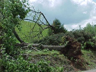 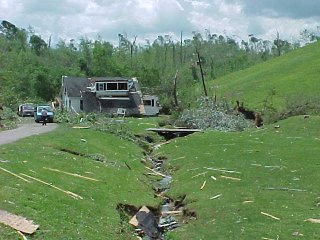 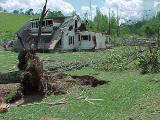 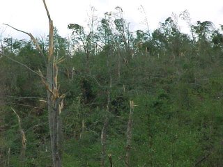 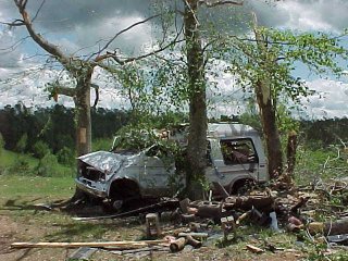 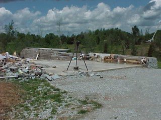 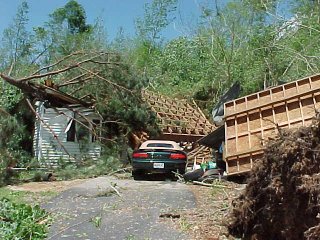 |
|
| F0 Williamson County Tornado | |
| Counties: | Williamson |
| Time: | 8:13 PM CST |
| EF Scale: | F0 |
| Damage Path Length: | 2.27 miles |
| Damage Path Width: | 50 yards |
| Fatalities: | 0 |
| Injuries | 0 |
| Damage: STORM DATA: Small trees were across the road. Some homes received damage to chimneys and roofs. SHAMBURGER (2015): Although NCDC and Storm Data list this event as thunderstorm wind damage, radar data, aerial imagery from Google Earth, and eyewitness reports from Bowie Nature Park personnel clearly indicates this damage was caused by a tornado, and this tornado was added to the NWS Nashville database. This F0 tornado touched down along Overbey Road southwest of Fairview, then moved northeast across Bowie Nature Park. Dozens of trees were blown down along the path, and a few homes received minor roof damage. Radar data suggests another weak tornado may have touched down in the Berry's Chapel Road area around 4 miles northwest of Franklin. |
|
| Nashville Airport Wind Damage | |
| Counties: | Davidson |
| Time: | 8:45 PM CST |
| Wind Speed: | 99 mph |
| Damage Path Length: | unknown |
| Damage Path Width: | unknown |
| Fatalities: | 0 |
| Injuries | 0 |
| Damage: STORM DATA: FAA wind equipment clocked a 99 mph wind gust in the strong thunderstorm downdrafts. 70 planes were damaged, and 2 hangars were destroyed. Many trees and power lines were down around the county. Debris and jet fuel was scattered across the runway. The airport was closed for several hours. Damage to the airport was $2.7 million. The hardest hit areas in Davidson county were Pennington Bend, Elysian Fields, Antioch, Old Hickory, east Nashville and Radnor lake. Part of a roof was lifted off Stratford H.S. Metro schools were cancelled on May 6 so crews could restore power and clean up debris around the county. SHAMBURGER (2015): No NWS Storm Survey was conducted for this damage, and radar data is also not available for this damage. However, the description and degree of damage at the airport, along with prior radar data across Williamson County, suggests this could have been a brief EF1 tornado. Other brief tornado touchdowns may have occurred in other areas of Davidson County. |
|
| F1 East Davidson County Tornado | |
| Counties: | Davidson |
| Time: | 8:45 PM CST |
| EF Scale: | F1 |
| Damage Path Length: | 0.1 miles |
| Damage Path Width: | 100 yards |
| Fatalities: | 0 |
| Injuries | 0 |
| Damage: STORM DATA: A weak tornado caused some roof damage to a few homes at a subdivision in Neely's Bend area of Davidson county. SHAMBURGER (2015): No NWS Storm Survey was conducted for this tornado, and radar data is also not available for this tornado. However, based on the narrative in Storm Data, the location was corrected to the Neely's Bend area of Nashville. |
|
| F1 North Davidson County Tornado | |
| Counties: | Davidson |
| Time: | 8:58 PM CST |
| EF Scale: | F1 |
| Damage Path Length: | 0.1 miles |
| Damage Path Width: | 100 yards |
| Fatalities: | 0 |
| Injuries | 0 |
| Damage: STORM DATA: A weak tornado caused some roof damage to a home on Shaw Rd. SHAMBURGER (2015): No NWS Storm Survey was conducted for this tornado, and radar data is also not available for this tornado. The location of the tornado was adjusted slightly based on the narrative in Storm Data. |
|
| F2 Sumner County Tornado | |
| Counties: | Sumner |
| Time: | 9:36 PM CST |
| EF Scale: | F2 |
| Damage Path Length: | 0.7 miles |
| Damage Path Width: | 220 yards |
| Fatalities: | 0 |
| Injuries | 17 |
| Damage: STORM DATA: The tornado touched down and struck the Rucker Stewart M.S. in the Gallatin city limits, continued northeast and hit the Greenwood Apartments and finally the Gallatin Post Office. The damage to the school and the post office was mainly roof damage. However, the Greenwood Apartments were the hardest hit. 40 families or 100 people were temporarily homeless. 3 apartment buildings were condemned. 17 people were treated at the Sumner Regional Medical Center and released. There were no serious injuries. SHAMBURGER (2015): NCDC incorrectly lists the path location for this tornado, which was corrected based on the narrative in Storm Data. No OHX radar data is available for this tornado. |
|

