| Tornado Statistics | ||||||||
| # | Counties | Rating | Time (CST) | Length (miles) | Width (yards) | Fatalities | Injuries | |
| 1 | Marshall | EF0 | 2332 | 3.1 | 100 | 0 | 0 | |
| Overview | |
| Another significant severe weather event struck Middle Tennessee just one week after the severe weather outbreak on March 1. During this event, a line of strong to severe thunderstorms with embedded circulations, known as a Quasi-Linear Convective System (or QLCS), moved rapidly southeastward across Middle Tennessee at 60-70 mph during the late evening hours on March 9, 2017 into the early morning hours on March 10, 2017. Ahead of the QLCS, isolated severe storms developed and produced large hail in many parts of Middle Tennessee during the evening on March 9. As the QLCS moved across the region, widespread damaging winds were reported in nearly every county along and west of I-24 across Middle Tennessee, with winds estimated up to 100 mph in some areas. These intense downbursts winds damaged numerous homes and businesses, and caused 1 injury in Warren County. In addition to the damaging winds, one confirmed tornado also touched down in Marshall County. |
| Radar | |
|
OHX radar loop from March 9, 2017 |
| Reports & Outlooks | |||
| SPC Storm Reports | SPC Event Archive | Local Storm Reports | Public Information Statements |
| EF0 Marshall County Tornado | |
| Counties: | Marshall |
| Time: | 11:32 PM CST |
| EF Scale: | EF0 |
| Estimated Peak Winds: | 80 mph |
| Damage Path Length: | 3.1 miles |
| Damage Path Width: | 100 yards |
| Fatalities: | 0 |
| Injuries | 0 |
|
Storm Survey: A brief EF-0 Tornado first touched down just south of the Belfast Community on Fishing Ford Road damaging some roofs on a few houses, destroying several outbuildings, and snapping several trees. The tornado continued on the ground east where additional damage occurred to several homes, outbuildings, and trees. The tornado quickly lifted before crossing the Bedford County line. |
|
 |
|
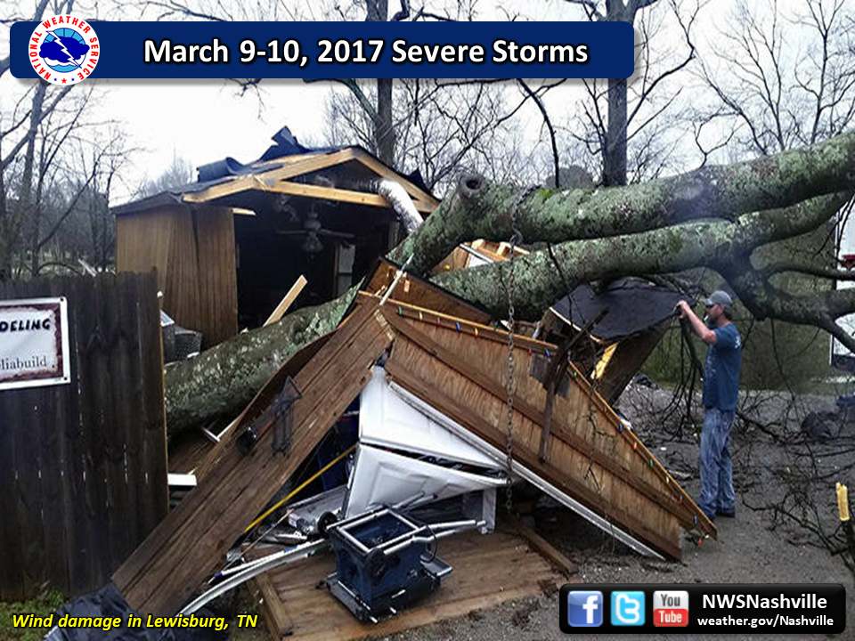
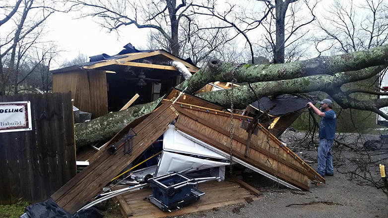
| Lewisburg Downburst | |
| Counties: | Marshall/Bedford |
| Time: | 11:27 PM to 11:36 PM CST |
| Estimated Peak Winds: | 100 mph |
| Damage Path Length: | 18 miles |
| Damage Path Width: | 1 mile to 2.5 miles |
| Fatalities: | 0 |
| Injuries | 0 |
|
Storm Survey: A NWS storm survey found a large, severe 18 mile long by 1 to 2.5 mile wide downburst struck areas in Marshall County from southern Lewisburg east-southeastward across Belfast, then continued into southwestern Bedford County before ending near Highway 231 south of Shelbyville. Widespread straight line wind damage occurred across the southern half of Lewisburg, with a tall radio tower bent in half on Skyline Drive. Part of the poorly-attached metal roof on a home on Gina Lynn Drive was blown up to 3/4 mile away. Another home had numerous shingles blown off on Midway Street near Scenic Drive, and a neighboring home had its metal carport destroyed. A barn lost part of its roof on Cornersville Road, and another carport was destroyed on Cornersville Road north of Highway 31A. An old warehouse building was heavily damaged on Old Belfast Road just west of Garrett Parkway, with much of the roof blown off and one wall collapsed. In addition, dozens of large trees were snapped and uprooted on Lakehill Drive, Green Valley Drive, Fox Lane, Midway Street, and others in southern Lewisburg. Farther to the east just west of Belfast, a barn lost much of its roof and a carport was destroyed on Old Belfast Road. Another barn was destroyed and numerous trees uprooted south of Belfast on Highway 431. Winds within the 1 mile wide downburst across Marshall County were estimated mainly in the 60-80 mph range, although pockets of damage such as the bent radio tower indicated winds reached 80 to 100 mph in some areas. In Bedford County, the porch was blown off a home on Cortner Hollow Road, and a barn had significant roof damage on Pickle Road. In the Richmond area, the sheet metal roof and walls were blown off an outbuilding on Sinking Creek Road, the roof was blown off a barn on Highway 130, and a gas station canopy collapsed on Highway 130 at Gant Hollow Road. Further to the east, another small barn was destroyed on Bluestocking Hollow Road at D Martin Road. Winds within the downburst across southwestern Bedford County, which was up to 2.5 miles wide, were estimated from 60 to 80 mph. |
|
 |
|
| Shelbyville Airport Downburst | |
| Counties: | Bedford |
| Time: | 11:36 PM CST |
| Estimated Peak Winds: | 95 mph |
| Damage Path Length: | 2 miles |
| Damage Path Width: | 0.5 miles |
| Fatalities: | 0 |
| Injuries | 0 |
|
Storm Survey: A severe microburst struck an industrial park area and the Shelbyville Airport north of Shelbyville. A tractor trailer was blown over at a warehouse on Northcreek Road. Significant damage occurred at the Shelbyville Airport Fire Station, where much of the roof was blown off, windows were blown out, and a steel beam on the building frame was twisted around 180 degrees. An old small airplane at the north end of the airport was flipped upside down and thrown 30 yards to the east, heavily damaging the plane. Unfortunately, the AWOS station at the Shelbyville Airport lost power, so no peak wind gusts were measured. Security cameras at the airport captured the microburst on video as well as a nearby power flash. |
|
 |
|
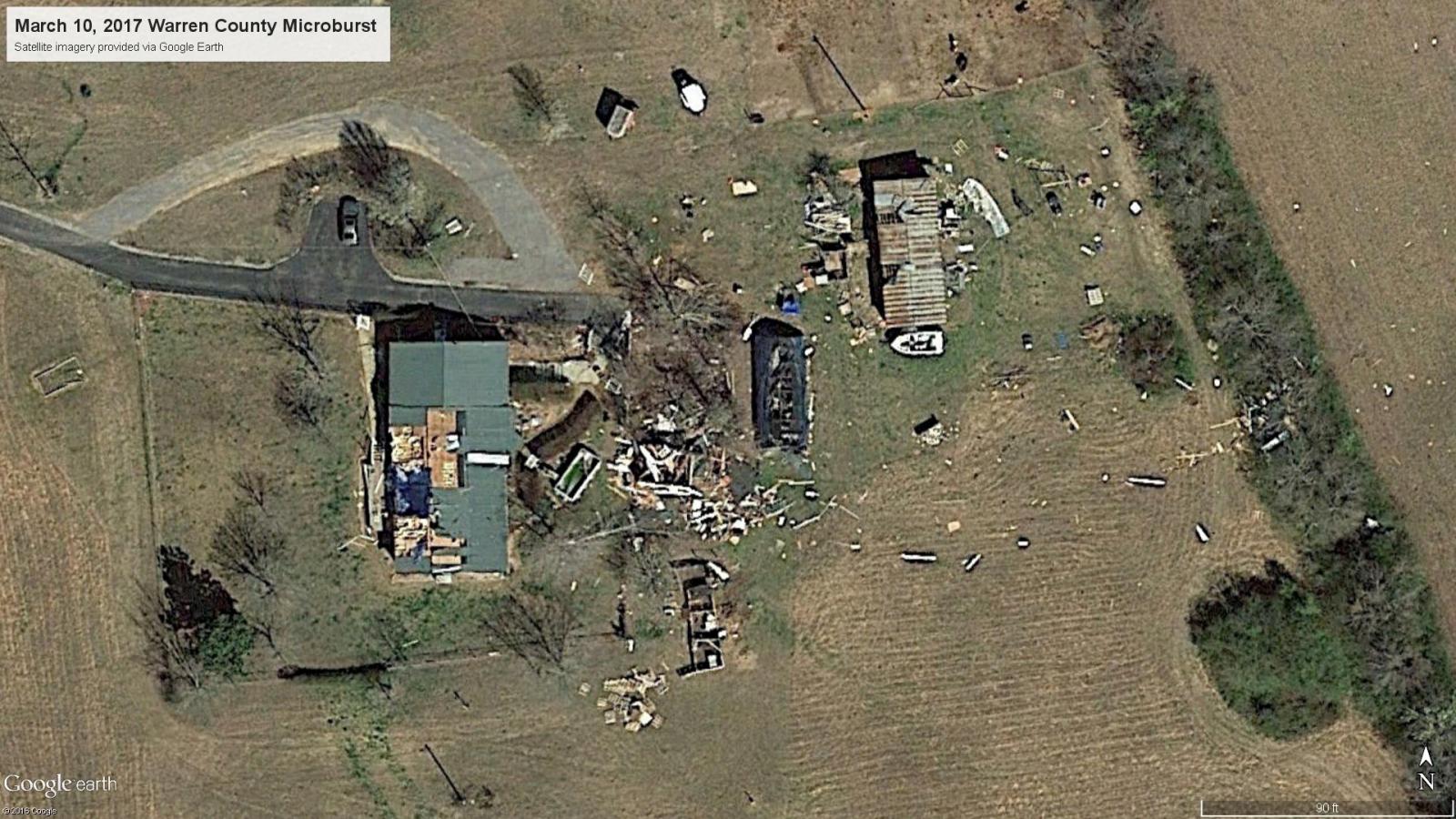
| Warren County Microburst | |
| Counties: | Warren |
| Time: | 12:04 AM CST |
| Estimated Peak Winds: | 95 mph |
| Damage Path Length: | 0.6 miles |
| Damage Path Width: | 150 yards |
| Fatalities: | 0 |
| Injuries | 1 |
|
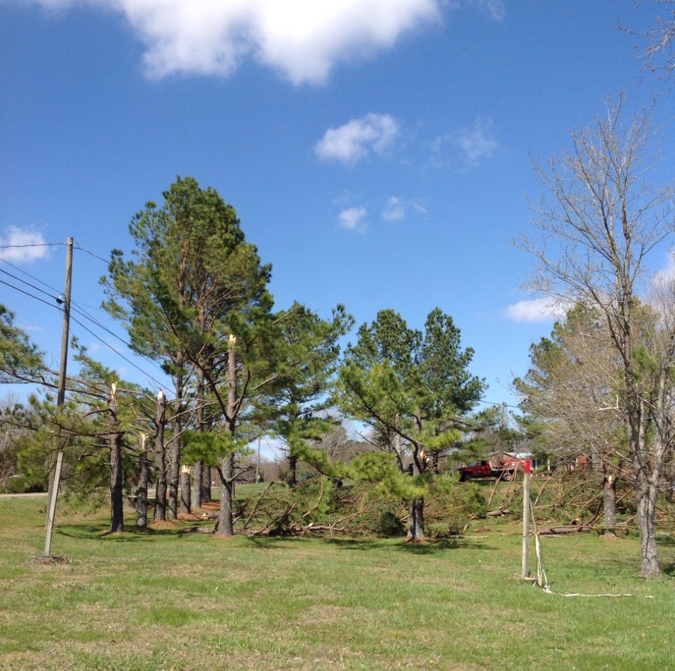
Storm Survey: A storm survey by Warren County Emergency Management along with Google Earth high resolution satellite imagery indicated a small but severe 0.6 mile long by 150 yard wide microburst struck far northern Warren County just south of the DeKalb County line. A few trees were blown down towards the east-northeast to the west of Highway 56 south of Meridian Drive. A home east of Highway 56 south of Gene Vaughn Road suffered severe wind damage, with the front porch and much of the roof blown off. One person inside the home was injured. Debris from the home was blown into fields over 250 yards to the east and northeast. In the backyard of the home, an outbuilding was destroyed, a greenhouse heavily damaged, the roof was blown off a chicken coop, and a barn lost some roof panels. Several trees were also snapped in the yard. No other damage was noted to the north, south, or east of the home. Winds were estimated up to 95 mph. |
|
 |
|

