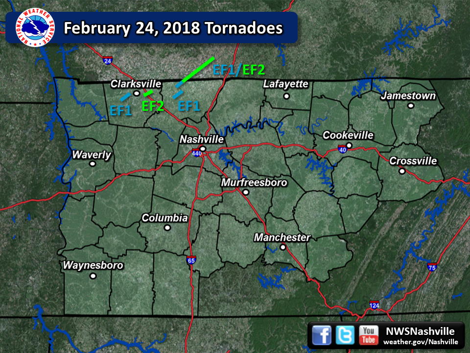
| Tornado Statistics | ||||||||
| # | Counties | Rating | Time (CST) | Length (miles) | Width (yards) | Fatalities | Injuries | |
| 1 | Robertson/Logan KY | EF1/EF2 | 1553 | 0.45 in TN | 150 | 0 (1 in KY) | 0 | |
| 2 | Montgomery | EF1 | 2050 | 5.04 | 150 | 0 | 0 | |
| 3 | Montgomery | EF2 | 2103 | 4.05 | 200 | 0 | 2 | |
| 4 | Robertson | EF1 | 2119 | 3.13 | 150 | 0 | 0 | |
| Overview | |
|
An intense storm system brought severe thunderstorms to northwest Middle Tennessee during the late afternoon and evening hours on February 24. One supercell thunderstorm developed along a warm front moving northward across the area during the afternoon, producing one tornado along the Kentucky/Tennessee border in Robertson County. Later in the evening, a Quasi-Linear Convective System (QLCS) moved into the area from the west, spawning three more tornadoes across Montgomery and Robertson County that damaged dozens of homes and businesses, and producing wind damage in several other areas. |
| Reports & Outlooks | |||
| SPC Storm Reports | SPC Event Archive | Local Storm Reports | Public Information Statements |
| Radar | |||
|
|||
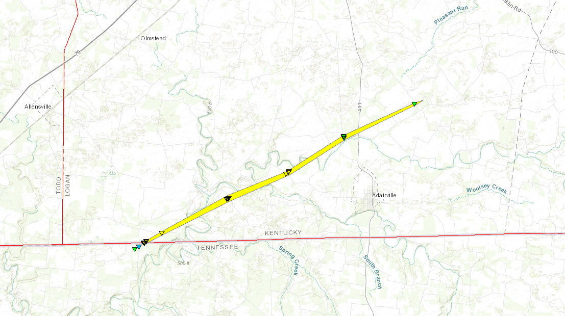
| EF1/EF2 Keysburg Tornado | |
| Counties: | Robertson/Logan KY |
| Time: | 3:53 PM CST |
| EF Scale: | EF1 (TN)/EF2 (KY) |
| Estimated Peak Winds (TN): | 105 mph |
| Damage Path Length (TN): | 0.45 miles |
| Damage Path Width (TN): | 150 yards |
| Fatalities (TN): | 0 |
| Injuries (TN): | 0 |
|
Storm Survey: This tornado began a half mile south of the Kentucky/Tennessee state line between Hugh Gill Road and Keysburg Road and produced EF-1 damage in Tennessee with numerous trees snapped and uprooted. The tornado moved northeast destroying the roof of a barn on Hugh Gill Road before hitting a home on McGhee Road causing significant roof and chimney damage. The tornado then moved into Kentucky where it caused preliminary EF-2 damage. Please refer to NWS Louisville for updated information on the Kentucky portion of the tornado path.
|
|
 |
 |
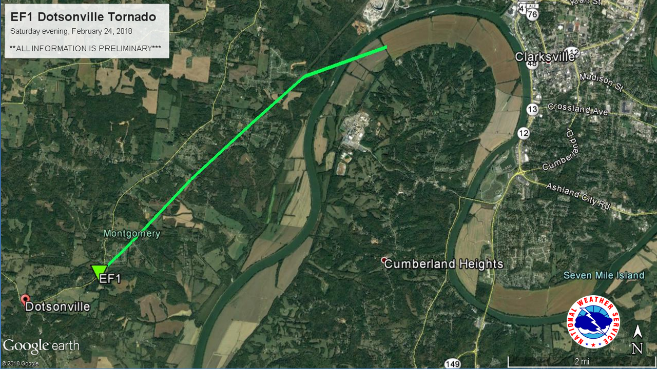
| EF1 Dotsonville Tornado | |
| Counties: | Montgomery |
| Time: | 8:50 PM CST |
| EF Scale: | EF1 |
| Estimated Peak Winds: | 105 mph |
| Path Length: | 5.04 miles |
| Path Width: | 150 yards |
| Fatalities: | 0 |
| Injuries: | 0 |
|
Storm Survey: An EF-1 tornado touched down near the Dotsonville community along Dotsonville Road at Bradley A. Martin Road and moved northeast. Trees were blown down and a few homes suffered minor roof damage on Gip Manning Road and Hunting Creek Road. Hundreds of trees were snapped or uprooted and 12 to 15 homes were damaged on Martin Road, Deepwood Drive, and Deepwood Trail with two homes severely damaged. More trees were blown down on Rustys Lane and along the Cumberland River before the tornado lifted. |
|
 |
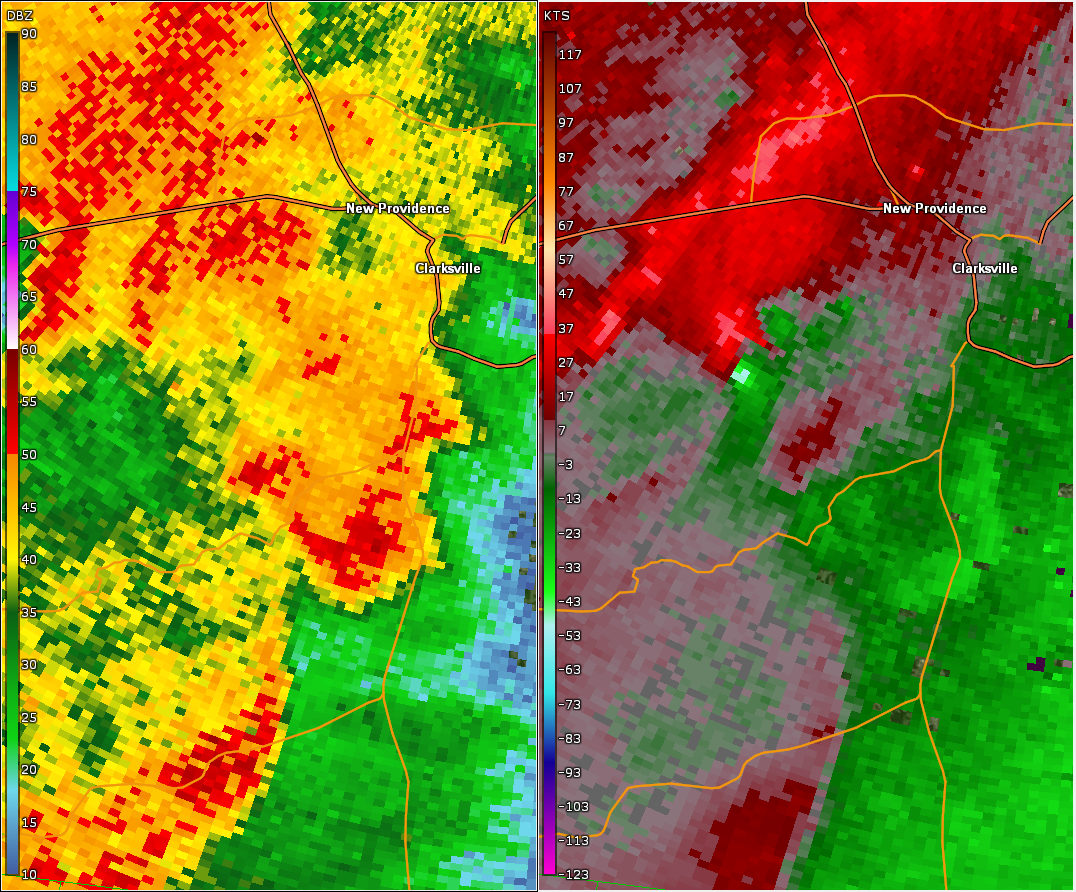 |
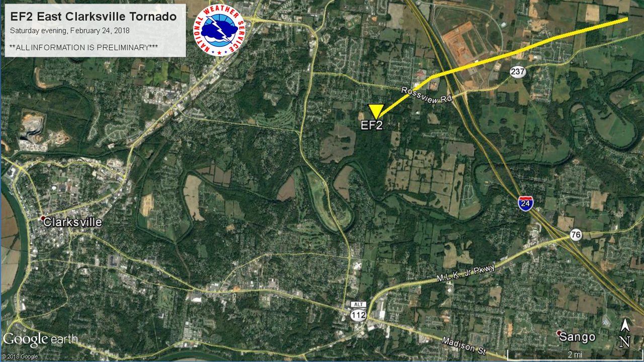
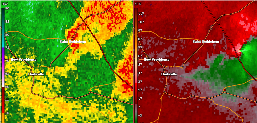
| EF2 East Clarksville Tornado | ||||||||
| Counties: | Montgomery | |||||||
| Time: | 9:03 PM CST | |||||||
| EF Scale: | EF2 | |||||||
| Estimated Peak Winds: | 125 mph | |||||||
| Damage Path Length: | 4.05 miles | |||||||
| Damage Path Width: | 150 yards | |||||||
| Fatalities: | 0 | |||||||
| Injuries | 2 | |||||||
|
Storm Survey:
|
||||||||
 |
 |
|||||||
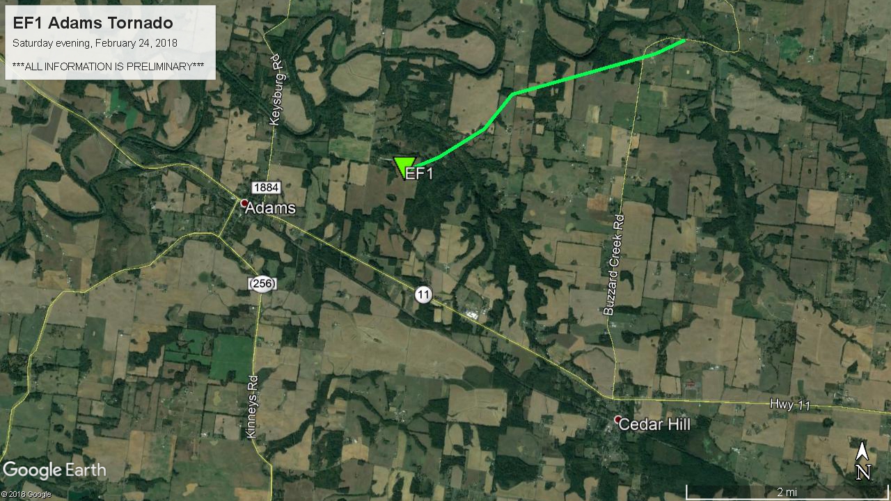
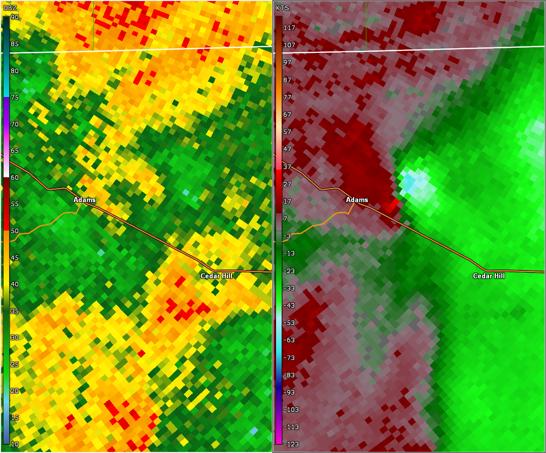
| EF1 Adams Tornado | |
| Counties: | Robertson |
| Time: | 9:19 PM CST |
| EF Scale: | EF1 |
| Estimated Peak Winds: | 95 mph |
| Path Length: | 3.13 miles |
| Path Width: | 150 yards |
| Fatalities: | 0 |
| Injuries: | 0 |
|
Storm Survey: An EF-1 tornado touched down east of Adams near Johnson Springs Road and moved northeast before ending along Buzzard Creek Road. Corn from a farm on the east side of Johnson Springs Road was blown over a quarter of a mile to the northeast. One home suffered minor roof damage on Sturgeon Creek Road and dozens of trees were snapped or uprooted along both Sturgeon Creek Road and Barnes Road. Several barns and outbuildings were damaged or destroyed along a bend of Buzzard Creek Road before the tornado lifted. |
|
 |
 |

