Overview
|
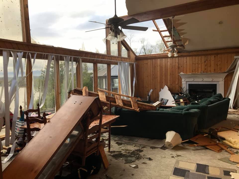
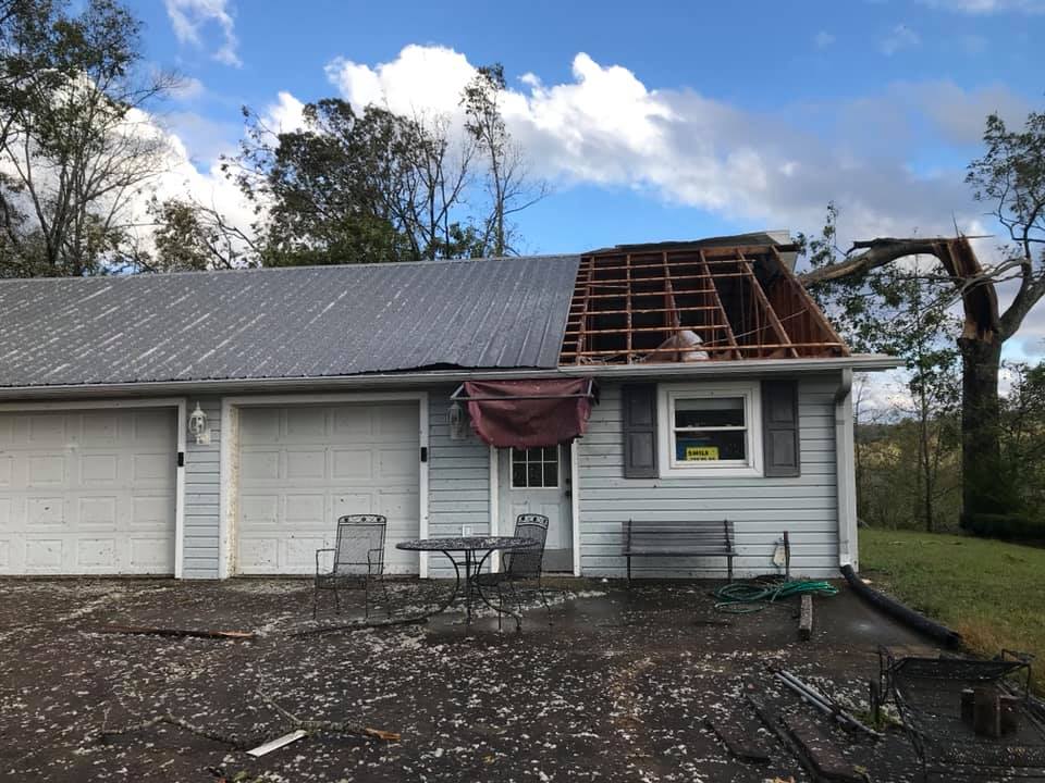
Saturday, October 26, 2019 began with the western two-thirds of Middle Tennessee under a Wind Advisory. A tightening pressure gradient, due to an approaching low pressure system (remnants of Tropical Storm Olga), produced wind gusts of 40+ mph in many locations. As the remnant tropical low approached from the south, reports of widespread wind damage were arriving out of north Mississippi and western Tennessee. Near the center of low pressure, a localized area of intense winds around 5 to 10 miles wide developed. These winds were not run-of-the-mill, thunderstorm-caused severe wind gusts, but hurricane-like severe winds driven by pressure falls near the center of former Tropical Storm Olga, and were accompanied by only light to moderate rain with no lightning or thunder. By 2:30 PM CDT, video footage of tractor trailers blown over on I-40 E was rolling in. That footage helped to verify a strong wind core, as seen by KHPX and KOHX, racing northeast into western Middle Tennessee. This prompted a severe thunderstorm warning (for winds est. 70 mph) for Humphreys, Dickson, Houston, Stewart, and Montgomery counties. Though winds of 100+ mph were being sampled by the HPX radar site around 2,000-3,500 feet, it is believed that these speeds did not reach the surface. Regardless, severe winds estimated between 70 and 90 mph did reach ground level and produced widespread damage across western Middle Tennessee. For example, portions of the Clarksville Airport and Clarksville Speedway were affected and over 40,000+ power outages occurred in and around Clarksville alone. Other locations from northwest Perry County across central Humphreys County, eastern Houston County, and western Montgomery County experienced widespread downed trees and power lines, along with some minor structural damage to homes and a few house fires. Many residents were without power for 1 to 2 weeks. This event goes to show that high winds, whether they are from a thunderstorm or an area of low pressure, can produce impressive damage regardless of how it was actually generated. |
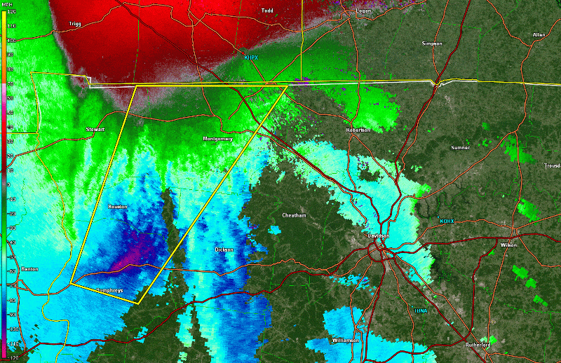 Radar Loop (Storm-relative motion) of severe winds |
Photos & Video
 |
 |
 |
 |
| Clarksville Airport (Mary Beth Haviland via WSMV) |
Clarksville Speedway (William and Laura Scogin via WKRN) |
I-40 Eastbound (Greg Allen via WKRN) |
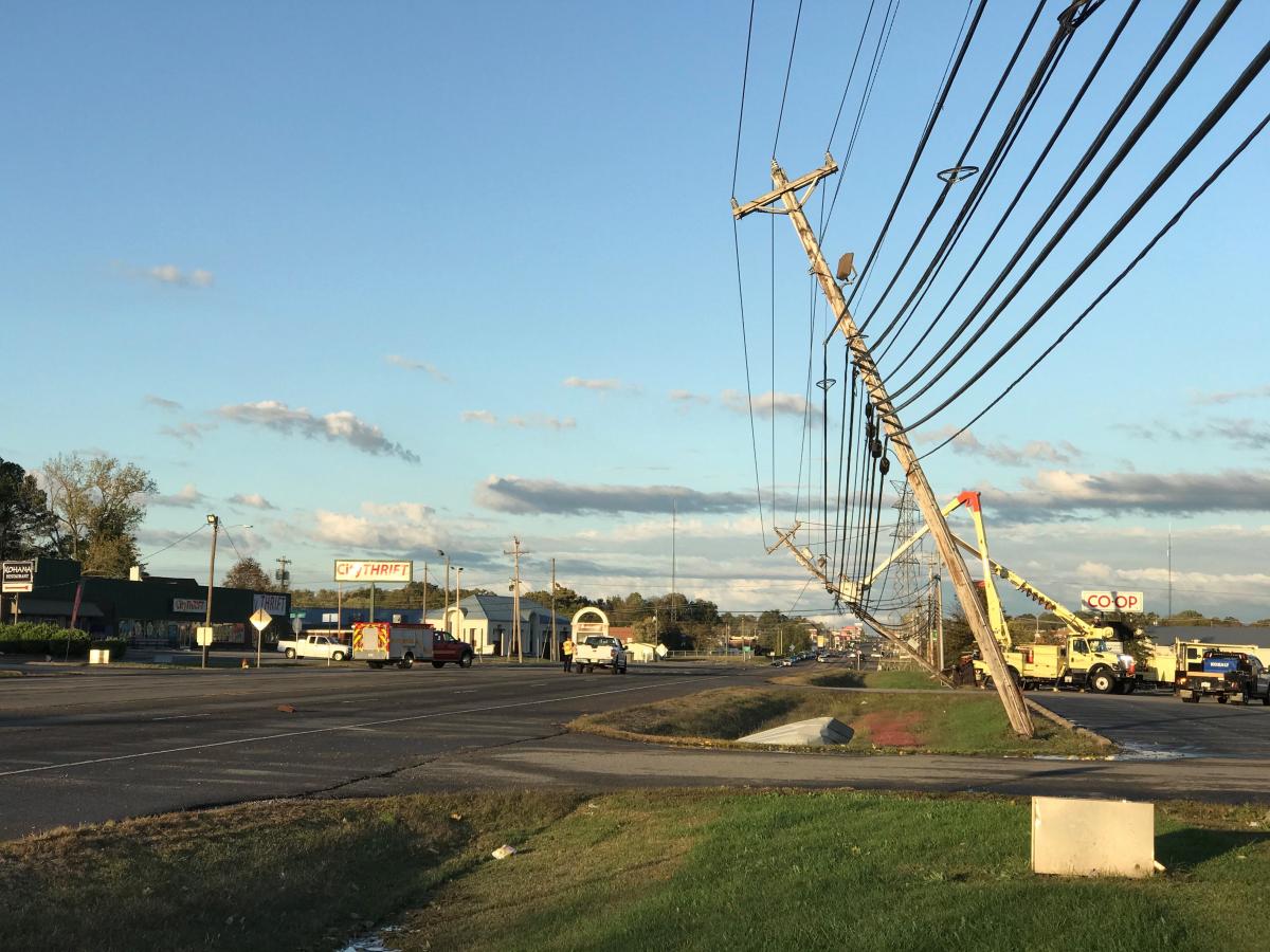
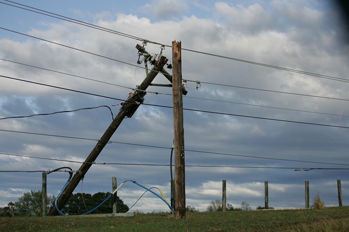
Power poles leaning in Clarksville (WRB Scott Chase) |
 |
 |
 |
 |
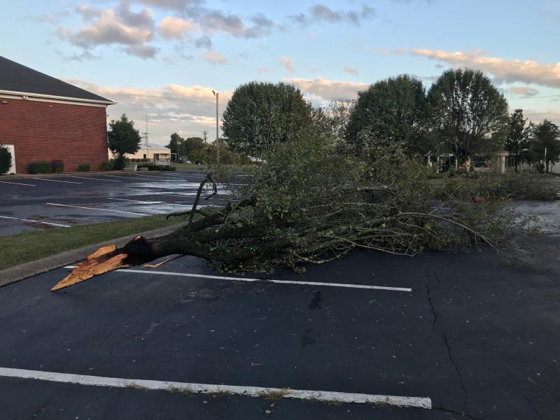
| Tree damage in Clarksville (Scott Chase) |
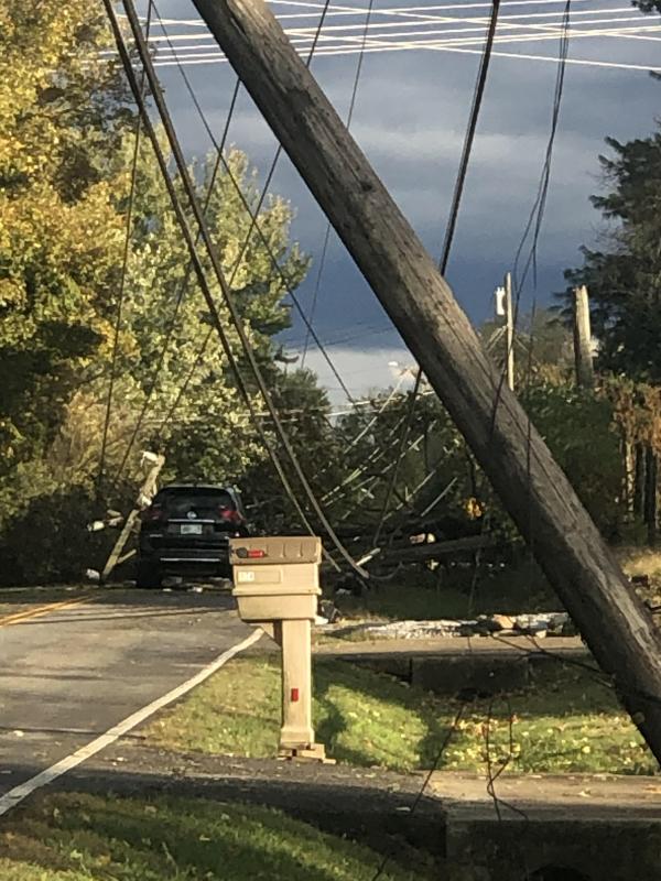
Power lines downed (Amanda Fryer) |
Trees fallen on car (Tina Binkley) |
Power pole damage in Clarksville (WKRN) |
 |
 |
 |
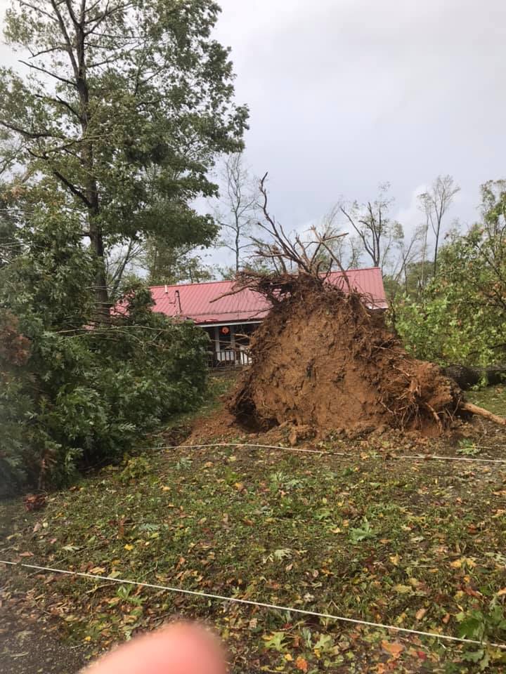 |
| Tree damage in NW Perry County (Alex Staarmann) |
Tree damage in NW Perry County (Alex Staarmann) |
Tree damage in NW Perry County (Alex Staarmann) |
Tree damage in NW Perry County (Alex Staarmann) |
 |
 |
 |
| Marina damage on the Tennessee River (Sky5 NC5) |
Tree damage in NW Perry County (Sky5 NC5) |
Tree damage in NW Perry County (Sky5 NC5) |
Radar
|
| Radar loop of storm-relative winds and severe thunderstorm warning |
Initial Warning and Storm Reports
Severe Thunderstorm Warning
BULLETIN - IMMEDIATE BROADCAST REQUESTED
Severe Thunderstorm Warning
National Weather Service Nashville TN
230 PM CDT Sat Oct 26 2019

The National Weather Service in Nashville has issued a

* Severe Thunderstorm Warning for...
  Northwestern Dickson County in Middle Tennessee...
  Montgomery County in Middle Tennessee...
  Eastern Stewart County in Middle Tennessee...
  Houston County in Middle Tennessee...
  Northern Humphreys County in Middle Tennessee...

* Until 315 PM CDT.

* At 229 PM CDT, a severe thunderstorm was located over Waverly,
  moving northeast at 60 mph.

  HAZARD...70 mph wind gusts.

  SOURCE...Radar indicated.

  IMPACT...Expect considerable tree damage. Damage is likely to
           mobile homes, roofs, and outbuildings.

* Locations impacted include...
  Clarksville, Waverly, Erin, McEwen, Tennessee Ridge, Vanleer,
  Cumberland City, Slayden, Indian Mound, Palmyra, Cunningham and
  Woodlawn.

Farmers and Artisan Market will also be impacted.

This includes Interstate 24 between mile markers 1 and 10.

PRECAUTIONARY/PREPAREDNESS ACTIONS...

For your protection move to an interior room on the lowest floor of a
building.

&&

LAT...LON 3664 8712 3599 8767 3605 8792 3664 8768
TIME...MOT...LOC 1929Z 212DEG 52KT 3611 8778

HAIL...<.75IN
WIND...70MPH

$$

Schaper
Storm Reports
PRELIMINARY LOCAL STORM REPORT...SUMMARY
NATIONAL WEATHER SERVICE NASHVILLE TN
548 PM CDT SUN OCT 27 2019

..TIME...   ...EVENT...      ...CITY LOCATION...     ...LAT.LON...
..DATE...   ....MAG....      ..COUNTY LOCATION..ST.. ...SOURCE....
            ..REMARKS..

0200 PM     TSTM WND DMG     5 W LINDEN              35.61N  87.93W
10/26/2019                   PERRY              TN   SOCIAL MEDIA

            TREES WERE BLOWN DOWN ACROSS THE AREA. A DOCK WAS
            DESTROYED AND METAL STRUCTURES WERE DAMAGED OR DESTROYED
            AT A CAMPGROUND.

0213 PM     TSTM WND DMG     10 S NEW JOHNSONVILLE   35.87N  87.94W
10/26/2019                   HUMPHREYS          TN   SOCIAL MEDIA

            SEVERAL 18 WHEELER TRUCKS WERE BLOWN OVER ALONG I-40 ON
            THE TENNESSEE RIVER BRIDGE.

0220 PM     TSTM WND DMG     ERIN                    36.32N  87.70W
10/26/2019                   HOUSTON            TN   SOCIAL MEDIA

            SEVERAL TREES WERE BLOWN DOWN AROUND ERIN.

0225 PM     TSTM WND DMG     WAVERLY                 36.09N  87.79W
10/26/2019                   HUMPHREYS          TN   SOCIAL MEDIA

            NUMEROUS TREES AND POWER LINES WERE DOWNED IN THE
            WAVERLY AREA. ROOFS, SIDING, SHEDS, AND CARPORTS WERE
            ALSO DAMAGED.

0227 PM     TSTM WND DMG     5 SSE NEW JOHNSONVILLE  35.96N  87.91W
10/26/2019                   HUMPHREYS          TN   PUBLIC

            MULTIPLE TREES DOWN, WITH ONE HOME RECEIVING DAMAGE
            FROM A FALLING TREE. LARGEST TREES DOWN AROUND 2 FEET IN
            DIAMETER.

0230 PM     TSTM WND DMG     MCEWEN                  36.11N  87.64W
10/26/2019                   HUMPHREYS          TN   SOCIAL MEDIA

            NUMEROUS TREES AND POWER LINES WERE BLOWN DOWN.

0245 PM     TSTM WND DMG     CUMBERLAND CITY         36.38N  87.64W
10/26/2019                   STEWART            TN   SOCIAL MEDIA

            TREES AND POWER LINES WERE BLOWN DOWN. MINOR STRUCTURE
            AND ROOF DAMAGE WAS REPORTED.

0300 PM     TSTM WND DMG     5 W CLARKSVILLE         36.55N  87.43W
10/26/2019                   MONTGOMERY         TN   TRAINED SPOTTER

            LARGE TREE BRANCH BLOWN DOWN, CAUSING DAMAGE TO FENCE.
            WINDS ESTIMATED AT 70 MPH.

0310 PM     TSTM WND DMG     CLARKSVILLE             36.56N  87.35W
10/26/2019                   MONTGOMERY         TN   TRAINED SPOTTER

            TREES AND POWER LINES WERE BLOWN DOWN NEAR AUSTIN PEAY
            STATE UNIVERSITY. SPOTTER ESTIMATES 60 TO 70 MPH WINDS.

0310 PM     TSTM WND DMG     CLARKSVILLE             36.56N  87.35W
10/26/2019                   MONTGOMERY         TN   TRAINED SPOTTER

            NUMEROUS TREES AND POWER LINES WERE BLOWN DOWN IN THE
            CLARKSVILLE AREA, ESPECIALLY THE WEST AND NORTH SIDES.
            ALSO, A COUPLE OF ROOF DAMAGE REPORTES WERE RECEIVED.

0315 PM     TSTM WND DMG     CLARKSVILLE             36.56N  87.35W
10/26/2019                   MONTGOMERY         TN   TRAINED SPOTTER

            NUMEROUS TREES AND POWER LINES WERE BLOWN DOWN. TREES
            FELL ON ROOFS AND CARS IN THE AREA AND SOME SHEDS WERE
            DESTROYED.


&&

EVENT NUMBER OHX1900562 OHX1900555 OHX1900557 OHX1900563 OHX1900560
OHX1900565 OHX1900564 OHX1900556 OHX1900558 OHX1900559 OHX1900561


$$

13
Highest Reported Wind Gusts
...HIGHEST WIND GUSTS FROM SATURDAY OCTOBER 26 2019...
Location Speed Time/Date Provider
Lawrenceburg 51 MPH 1235 PM 10/26 AWOS
Nashville 47 MPH 0219 PM 10/26 ASOS
Clarksville 46 MPH 0155 PM 10/26 ASOS
Dickson 46 MPH 0235 PM 10/26 AWOS
Lewisburg 44 MPH 0115 PM 10/26 AWOS
Lebanon 44 MPH 0255 PM 10/26 AWOS
Murfreesboro 43 MPH 0215 PM 10/26 AWOS
Shelbyville 41 MPH 0155 PM 10/26 AWOS
2.3 SW Nashville (WEATHERSTE 40 MPH 0250 PM 10/26 MESOWEST
Gallatin 40 MPH 0315 PM 10/26 AWOS
Fort Campbell 39 MPH 0315 PM 10/26 RAWS
3 SSW Pulaski 39 MPH 1155 AM 10/26 AWOS
3.2 SW Pulaski (NWS/FAA) 39 MPH 1155 AM 10/26 MESOWEST
Smyrna 39 MPH 0209 PM 10/26 AWOS
Sparta 39 MPH 0155 PM 10/26 AWOS
Columbia 38 MPH 1235 PM 10/26 AWOS
Tullahoma 38 MPH 1115 AM 10/26 AWOS
Portland 37 MPH 0335 PM 10/26 AWOS
Crossville 36 MPH 0112 PM 10/26 ASOS
Livingston 35 MPH 0315 PM 10/26 AWOS
4.3 E Columbia (WEATHERSTEM) 34 MPH 0140 PM 10/26 MESOWEST
Nashv Jc Tune 33 MPH 0235 PM 10/26 AWOS
Lewisburg Tower 32 MPH 0206 PM 10/26 RAWS
Stilly Hollow 32 MPH 0626 PM 10/26 RAWS
Mcminnville 31 MPH 0135 PM 10/26 AWOS
Meriwether Lewis 31 MPH 0222 PM 10/26 RAWS
Observations are collected from a variety of sources with varying
equipment and exposures. We thank all volunteer weather observers
for their dedication. Not all data listed are considered official.
$$
 |
Media use of NWS Web News Stories is encouraged! Please acknowledge the NWS as the source of any news information accessed from this site. |
|

