Overview
|
A line of severe thunderstorms rumbled across Middle Tennessee during the night and early morning hours of March 28-29, 2020. The storm system that was responsible for these damaging storms took shape over the north-central Plains and continued toward the Great Lakes Region. Further south, a cold front was racing east across the Mid and Lower Mississippi Valleys. Sufficient instability and wind shear was in place across Middle Tennessee to intensify storms ahead of the cold front. Line segments of damaging wind and hail formed over western Middle TN and southern AL, racing east-northeast at speeds of 60-80 mph! Widespread wind damage and large hail was reported as the system tracked across Stewart, Maury, Marshall, Bedford, Coffee, Cannon, DeKalb, Warren, Van Buren, White, Overton, Cumberland, and Fentress Counties. Wind speeds were estimated as high as 95 mph in some areas. Peak wind speeds measured at area weather station included 69 MPH at Short Mountain (Cannon County), 63 MPH at Clarksville Outlaw Field (Montgomery County), and 63 MPH at Crossville Memorial Airport (63 MPH). In addition, one EF-0 tornado was determined to have touched down in White County. |
|
Photos
 |
 |
 |
 |
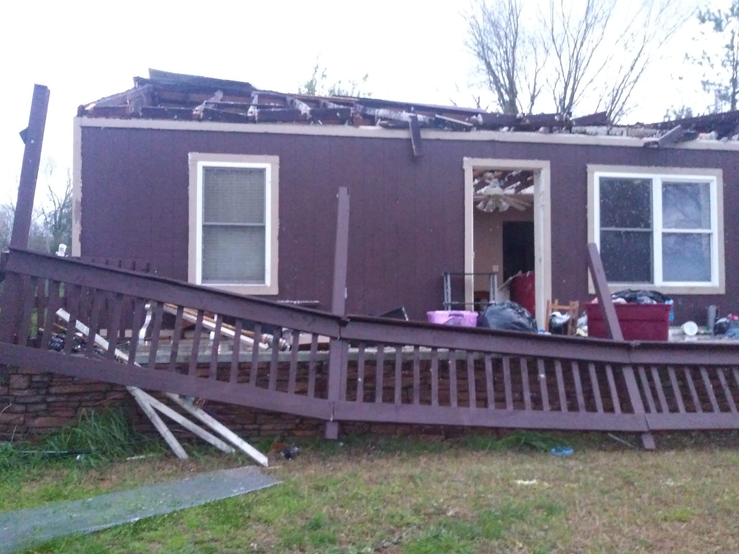
| Beechgrove, TN (Lindsey Brothers Smalley) |
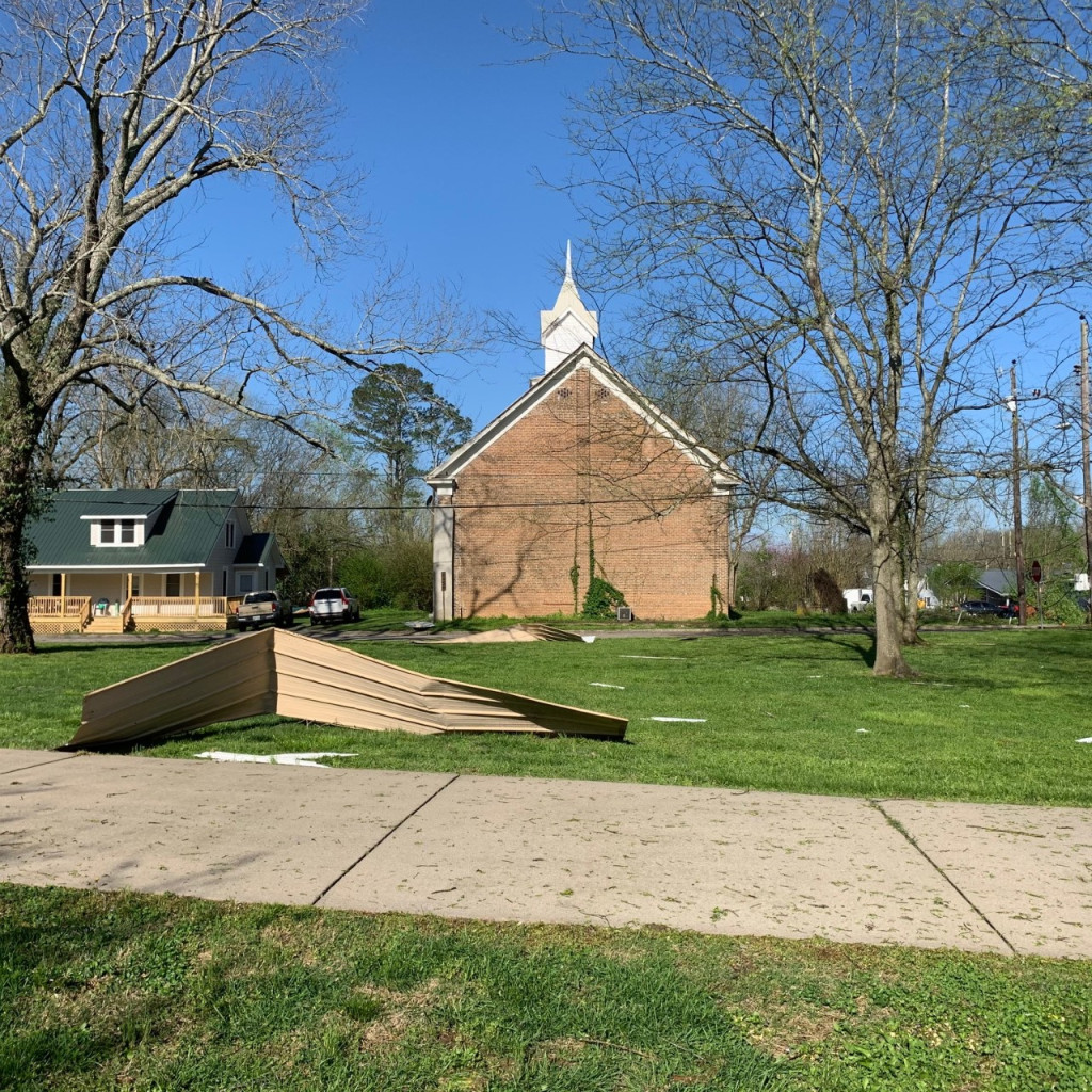
Bell Buckle, TN (source TBD) |
Bell Buckle, TN (source TBD) |
Bell Buckle, TN (source TBD) |
 |
 |
 |
 |
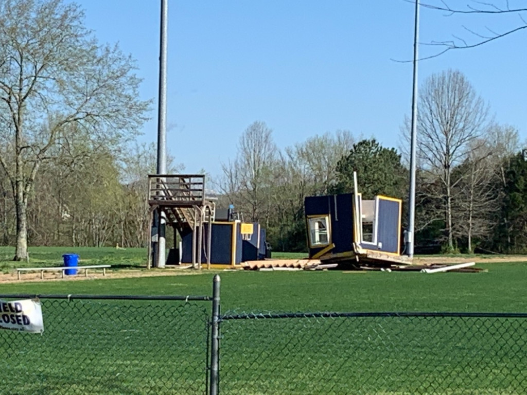
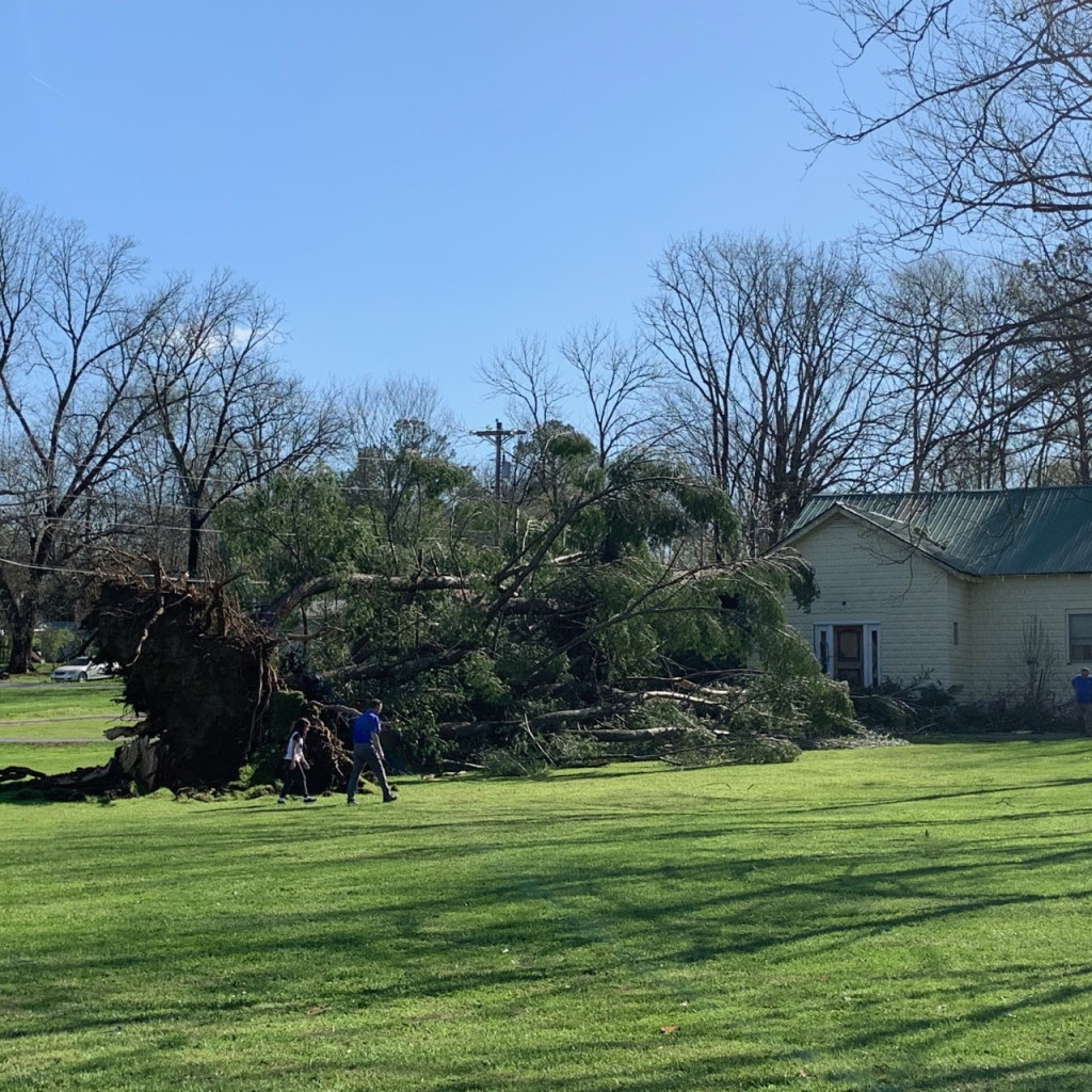
| DeKalb County, TN (source TBD) |
Monterey, TN (source TBD) |
Shelbyville, TN (source TBD) |
Sparta, TN (April Camacho) |
Radar Loop
Storm Reports
PRELIMINARY LOCAL STORM REPORT...SUMMARY
NATIONAL WEATHER SERVICE NASHVILLE TN
726 AM CDT SAT APR 04 2020

..TIME...   ...EVENT...      ...CITY LOCATION...     ...LAT.LON...
..DATE...   ....MAG....      ..COUNTY LOCATION..ST.. ...SOURCE....
            ..REMARKS..

0717 PM     HAIL             DOVER                   36.48N  87.84W
03/28/2020  E1.75 INCH       STEWART            TN   SOCIAL MEDIA

            DELAYED FACEBOOK REPORT OF GOLF BALL SIZE HAIL IN
            DOVER.

1001 PM     TSTM WND DMG     DOVER                   36.48N  87.84W
03/28/2020                   STEWART            TN   EMERGENCY MNGR

            TREES DOWN ON COX HOLLOW RD...ONE ON HOUSE.

1034 PM     TSTM WND GST     CLARKSVILLE             36.56N  87.35W
03/28/2020  M63 MPH          MONTGOMERY         TN   ASOS

            MEASURED 63 MPH WIND GUST AT THE CKV ASOS

1042 PM     TSTM WND GST     8 ESE CLARKSVILLE       36.50N  87.23W
03/28/2020  E60 MPH          MONTGOMERY         TN   TRAINED SPOTTER

            TRAINED SPOTTER ESTIMATED 60 MPH WINDS IN SANGO AND
            WITNESSED MULTIPLE POWER FLASHES

1106 PM     TSTM WND DMG     9 NNE SPRINGFIELD       36.63N  86.84W
03/28/2020                   ROBERTSON          TN   FIRE DEPT/RESCUE

            ROOF BLOWN OFF EQUIPMENT SHED AND TREES DAMAGED AT 5544
            ASHBURN ROAD

1132 PM     TSTM WND DMG     COLUMBIA                35.62N  87.05W
03/28/2020                   MAURY              TN   EMERGENCY MNGR

            SIGNAL LIGHT BLOWN DOWN AT THE INTERSECTION OF
            HAMPSHIRE PIKE AND LION PARKWAY.

1152 PM     TSTM WND DMG     COLUMBIA                35.62N  87.05W
03/28/2020                   MAURY              TN   SOCIAL MEDIA

            TREE BLOWN DOWN IN BACKYARD OF HOME

1235 AM     HAIL             LORETTO                 35.08N  87.44W
03/29/2020  E1.00 INCH       LAWRENCE           TN   EMERGENCY MNGR

1235 AM     HAIL             LORETTO                 35.08N  87.44W
03/29/2020  E1.25 INCH       LAWRENCE           TN   EMERGENCY MNGR

1239 AM     HAIL             6 S LAWRENCEBURG        35.16N  87.35W
03/29/2020  E0.88 INCH       LAWRENCE           TN   EMERGENCY MNGR

            ALSO REPORTED 50 MPH WINDS IN LEOMA.

1239 AM     HAIL             6 S LAWRENCEBURG        35.16N  87.35W
03/29/2020  E1.00 INCH       LAWRENCE           TN   SOCIAL MEDIA

            REPORT FROM LEOMA. TIME ESTIMATED FROM RADAR

0111 AM     TSTM WND DMG     1 SW LEWISBURG          35.44N  86.80W
03/29/2020                   MARSHALL           TN   SOCIAL MEDIA

            LARGE TREE DOWN ON GALLOWAY ST

0114 AM     TSTM WND DMG     1 SW LEWISBURG          35.44N  86.80W
03/29/2020                   MARSHALL           TN   EMERGENCY MNGR

            LARGE TREES BLOCKING 900 BLOCK OF GALLOWAY STREET.

0116 AM     TSTM WND DMG     1 SSW LEWISBURG         35.44N  86.79W
03/29/2020                   MARSHALL           TN   EMERGENCY MNGR

            TREES ON A POWER LINE AS WELL AS POWER LINE DAMAGE NEAR
            CORNERSVILLE RD.

0127 AM     TSTM WND DMG     7 NNW SHELBYVILLE       35.57N  86.51W
03/29/2020                   BEDFORD            TN   SOCIAL MEDIA

            SEVERAL SPRUCE TREES SNAPPED AT GREGORY MILL ROAD AND
            OLD NASHVILLE DIRT RD. TIME ESTIMATED FROM RADAR

0133 AM     TSTM WND DMG     5 NNW SHELBYVILLE       35.56N  86.47W
03/29/2020                   BEDFORD            TN   SOCIAL MEDIA

            UPROOTED TREE AND LARGE WOODEN STRUCTURE TIPPED OVER AT
            HARTS CHAPEL ROAD AND MIDLAND ROAD. TIME ESTIMATED FROM
            RADAR

0135 AM     TSTM WND DMG     4 SW SHELBYVILLE        35.46N  86.51W
03/29/2020                   BEDFORD            TN   EMERGENCY MNGR

            TREES AND POWER LINES DOWN ON HIGHWAY 64.

0137 AM     TSTM WND DMG     5 N SHELBYVILLE         35.56N  86.45W
03/29/2020                   BEDFORD            TN   EMERGENCY MNGR

            MULTIPLE TELEPHONE POLES DOWN ALONG HIGHWAY 231 N NEAR
            THE AIRPORT

0138 AM     TSTM WND DMG     BELL BUCKLE             35.59N  86.36W
03/29/2020                   BEDFORD            TN   SOCIAL MEDIA

            LARGE TREE UPROOTED. TIME ESTIMATED FROM RADAR.

0139 AM     TSTM WND DMG     4 WSW BELL BUCKLE       35.56N  86.41W
03/29/2020                   BEDFORD            TN   SOCIAL MEDIA

            TSPOTTER REPORT OF A TREE ON A HOME ON MINKSLIDE RD.

0147 AM     HAIL             BEECHGROVE              35.63N  86.24W
03/29/2020  M0.75 INCH       COFFEE             TN   SOCIAL MEDIA

            PHOTO ON TWITTER. TIME ESTIMATED FROM RADAR.

0149 AM     TSTM WND DMG     2 SSW BRADYVILLE        35.71N  86.18W
03/29/2020                   CANNON             TN   SOCIAL MEDIA

            SIDING DAMAGE TO A HOME ON TOLBERT HOLLOW RD.

0150 AM     TSTM WND DMG     BEECHGROVE              35.63N  86.24W
03/29/2020                   COFFEE             TN   SOCIAL MEDIA

            TREES AND POWERLINES DOWN ACROSS THE BEECHGROVE AREA.

0155 AM     TSTM WND GST     8 SE BRADYVILLE         35.66N  86.07W
03/29/2020  M56 MPH          CANNON             TN   SOCIAL MEDIA

            TIME ESTIMATED FROM RADAR

0155 AM     TSTM WND DMG     4 N WOODBURY            35.88N  86.07W
03/29/2020                   CANNON             TN   SOCIAL MEDIA

            TREES DOWN AND ONE CARPORT THROWN ON DOOLITTLE RD.

0156 AM     TSTM WND DMG     6 ESE BRADYVILLE        35.70N  86.06W
03/29/2020                   CANNON             TN   SOCIAL MEDIA

            MULTIPLE TREES DOWN IN THE WOODLAND COMMUNITY INCLUDING
            ONE THROUGH THE ROOF OF A HOME.

0157 AM     TSTM WND DMG     6 SSE WOODBURY          35.74N  86.05W
03/29/2020                   CANNON             TN   SOCIAL MEDIA

            TREES DOWN IN THE HIDDEN VALLEY NEIGHBORHOOD INCLUDING
            ONE THAT FELL ON TWO CARS.

0157 AM     TSTM WND DMG     6 WSW CENTERTOWN        35.70N  86.01W
03/29/2020                   CANNON             TN   SOCIAL MEDIA

            CATTLE BARN ROOF REMOVED. RADAR ESTIMATED TIME.

0200 AM     TSTM WND DMG     CENTER HILL             35.79N  85.96W
03/29/2020                   CANNON             TN   TRAINED SPOTTER

            TREES AND POWER LINES DOWN ACROSS HWY 146 AT HWY 281.

0200 AM     TSTM WND DMG     2 NW CENTER HILL        35.81N  85.98W
03/29/2020                   CANNON             TN   SOCIAL MEDIA

            UP TO 8 LARGE TREES BLOWN DOWN. OFF PARCHCORN HOLLOW
            ROAD.

0200 AM     TSTM WND GST     6 ENE WOODBURY          35.86N  85.97W
03/29/2020  M69 MPH          CANNON             TN   TRAINED SPOTTER

            MEASURED BY DAVIS WEATHER STATION ON TOP OF SHORT
            MOUNTAIN

0200 AM     TSTM WND DMG     WOODBURY                35.82N  86.07W
03/29/2020                   CANNON             TN   TRAINED SPOTTER

            TREES DOWN ALONG STONES RIVER RD...1 TREE FELL ON A
            TRUCK.

0203 AM     TSTM WND DMG     3 NE CENTER HILL        35.82N  85.92W
03/29/2020                   CANNON             TN   SOCIAL MEDIA

            TREES SNAPPED AND UPROOTED ON OSEMENT ROAD IN THE SHORT
            MTN AREA

0207 AM     TSTM WND DMG     3 S SMITHVILLE          35.91N  85.82W
03/29/2020                   DE KALB            TN   SOCIAL MEDIA

            GAS STATION SIGN DAMAGED, POWER POLE SNAPPED

0207 AM     TSTM WND DMG     3 WNW SMITHVILLE        35.98N  85.87W
03/29/2020                   DE KALB            TN   SOCIAL MEDIA

            POWER POLE SNAPPED, ALONG WITH 4 LARGE OAKS DOWN

0210 AM     TSTM WND DMG     8 E SMITHVILLE          35.97N  85.68W
03/29/2020                   DE KALB            TN   SOCIAL MEDIA

            LIGHT POLES DOWN AND METAL SIDING SPREAD AROUND
            BILLINGS ROAD NEAR SMITHVILLE. TIME ESTIMATED FROM
            RADAR.

0210 AM     TSTM WND DMG     9 N MCMINNVILLE         35.81N  85.79W
03/29/2020                   WARREN             TN   SOCIAL MEDIA

            IN DIBRELL; TREES DOWN, SHINGLES BLOWN OFF OF A HOUSE
            AND SHED. SIDING DAMAGE TO THE HOME AS WELL AS A FLAG
            POLE BENT.

0211 AM     TSTM WND DMG     3 ESE CENTER HILL       35.77N  85.92W
03/29/2020                   WARREN             TN   SOCIAL MEDIA

            METAL CAR GARAGE DESTROYED. TIME ESTIMATED FROM RADAR.

0212 AM     TSTM WND DMG     6 W SPARKMAN            35.79N  85.61W
03/29/2020                   WARREN             TN   SOCIAL MEDIA

            DOWNED POWER LINES, SNAPPED AND UPROOTED TREES IN THE
            AREA OF ROCK ISLAND

0212 AM     TSTM WND DMG     4 SW SPARKMAN           35.77N  85.58W
03/29/2020                   VAN BUREN          TN   SOCIAL MEDIA

            VERY LARGE UPROOTED TREE. TIME ESTIMATED FROM RADAR.

0218 AM     TSTM WND DMG     4 SW SPARKMAN           35.77N  85.57W
03/29/2020                   VAN BUREN          TN   SOCIAL MEDIA

            TREE THROUGH A LARGE METAL BARN

0223 AM     TSTM WND DMG     DOYLE                   35.85N  85.51W
03/29/2020                   WHITE              TN   SOCIAL MEDIA

            METAL SHED ROOD IN POWERLINES, MULTIPLE TREES DOWN

0226 AM     TSTM WND DMG     7 W SPARTA              35.93N  85.59W
03/29/2020                   WHITE              TN   SOCIAL MEDIA

            TREES UPROOTED, FLAG POLE BENT, FRONT PORCH PULLED FROM
            CONCRETE POST AT OLD ZION CEMETERY IN CASSVILLE

0226 AM     TSTM WND DMG     2 SSW SPARTA            35.91N  85.49W
03/29/2020                   WHITE              TN   SOCIAL MEDIA

            TRAIN CARS FLIPPED OFF TRACK NEAR IRIS DRIVE. TIME
            ESTIMATED FROM RADAR.

0230 AM     TSTM WND DMG     SPARTA                  35.93N  85.47W
03/29/2020                   WHITE              TN   EMERGENCY MNGR

            REPORTS OF TREES DOWN AND ROOFS BLOWN OFF OF HOMES NEAR
            BON AIR, DOYLE, AND SPARTA.

0230 AM     TSTM WND DMG     4 NNW SPARTA            35.98N  85.50W
03/29/2020                   WHITE              TN   MEDIA

            TREES DOWN AND POWER OUTAGES REPORTED NEAR RIDGEWOOD DR
            IN NORTH SPARTA.

0232 AM     TSTM WND DMG     7 ENE SPARTA            35.99N  85.37W
03/29/2020                   WHITE              TN   911 CALL CENTER

            12 HOMES RECEIVED DAMAGE AT BON AIR MOUNTAIN

0235 AM     TSTM WND DMG     5 W PLEASANT HILL       35.98N  85.30W
03/29/2020                   WHITE              TN   SOCIAL MEDIA

            BACK PORCH ROOF BLOWN OFF A HOUSE IN THE RAVENSCROFT
            AREA.

0239 AM     TSTM WND DMG     2 W PLEASANT HILL       35.97N  85.23W
03/29/2020                   CUMBERLAND         TN   SOCIAL MEDIA

            A TREE FELL THROUGH A HOME ON GLADE CREEK RD.

0240 AM     TSTM WND DMG     PLEASANT HILL           35.97N  85.19W
03/29/2020                   CUMBERLAND         TN   MEDIA

            TREES DOWN ALONG HWY 70 NEAR PLEASANT HILL WITH POWER
            OUTAGES NEAR MAYLAND AND CROSSVILLE.

0240 AM     TSTM WND DMG     1 S PLEASANT HILL       35.96N  85.20W
03/29/2020                   CUMBERLAND         TN   SOCIAL MEDIA

            SEVERAL TREES DOWN ON DECK RD INCLUDING A LARGE TREE
            THAT FELL ON A HOUSE.

0243 AM     TSTM WND DMG     1 N BAKER CROSSROADS    36.00N  85.11W
03/29/2020                   CUMBERLAND         TN   SOCIAL MEDIA

            GLASS SLIDING DOOR SHATTERED, GUTTERS DAMAGED, AND
            TRAMPOLINE CRUMPLED AT A HOUSE ON CARTER TOWN RD.

0244 AM     TSTM WND DMG     3 SSE BAKER CROSSROADS  35.96N  85.08W
03/29/2020                   CUMBERLAND         TN   SOCIAL MEDIA

            SEVERAL HOUSES WITH DAMAGE ON NORMAN DR.

0244 AM     TSTM WND DMG     6 NE MONTEREY           36.19N  85.17W
03/29/2020                   OVERTON            TN   EMERGENCY MNGR

            LARGE TREE FELL ON POWERLINE, CUTTING POWER TO OVER
            1000 CUSTOMERS.

0245 AM     TSTM WND DMG     2 NNW CROSSVILLE        35.98N  85.06W
03/29/2020                   CUMBERLAND         TN   SOCIAL MEDIA

            TREES DOWN AND GAZEBO BLOWN OVER.

0245 AM     TSTM WND DMG     2 NNW CROSSVILLE        35.98N  85.06W
03/29/2020                   CUMBERLAND         TN   SOCIAL MEDIA

            DAMAGE TO A HOME ON EUREKA DR INCLUDING SHIFTING OF THE
            ROOF.

0246 AM     TSTM WND DMG     3 NNW LAKE TANSI        35.91N  85.08W
03/29/2020                   CUMBERLAND         TN   SOCIAL MEDIA

            TREES DOWN AND A TRACTOR TRAILER BLOWN OVER ON TAYLOR'S
            CHAPEL RD.

0246 AM     TSTM WND DMG     3 NNE CROSSVILLE        35.99N  85.02W
03/29/2020                   CUMBERLAND         TN   SOCIAL MEDIA

            SEVERAL TREES DOWN IN YARD. TIME ESTIMATED FROM RADAR.

0246 AM     TSTM WND DMG     CROSSVILLE              35.95N  85.04W
03/29/2020                   CUMBERLAND         TN   SOCIAL MEDIA

            TREES/DEBRIS BLOCKING WESTBOUND I-40 AT MM 319

0246 AM     TSTM WND DMG     3 NE BAKER CROSSROADS   36.03N  85.07W
03/29/2020                   CUMBERLAND         TN   SOCIAL MEDIA

            TREES DOWN AND STRUCTURAL DAMAGE AT CRESTON RD AND
            BRISTOW RD.

0246 AM     TSTM WND DMG     2 N CROSSVILLE          35.98N  85.04W
03/29/2020                   CUMBERLAND         TN   SOCIAL MEDIA

            SIDING PEELED, FENCES BLOWN DOWN, AND AN A/C UNIT BLOWN
            OFF FOUNDATION AT CHARLESTON PLANTATION.

0246 AM     TSTM WND DMG     2 NNW CROSSVILLE        35.98N  85.05W
03/29/2020                   CUMBERLAND         TN   EMERGENCY MNGR

            SIGNIFICANT COLLAPSE OF WALLS AND ROOF OF A WAREHOUSE
            BUILDING AT THE CORNER OF HWY 70N AND NORTHSIDE DR.

0246 AM     TSTM WND GST     2 WNW CROSSVILLE        35.96N  85.08W
03/29/2020  M63 MPH          CUMBERLAND         TN   ASOS

            PEAK WIND GUST OF 63 MPH MEASURED AT CSV ASOS

0247 AM     TSTM WND DMG     2 N CROSSVILLE          35.98N  85.04W
03/29/2020                   CUMBERLAND         TN   SOCIAL MEDIA

            TREES DOWN ON OLD JAMESTOWN HWY.

0247 AM     TSTM WND DMG     1 NNW CROSSVILLE        35.97N  85.04W
03/29/2020                   CUMBERLAND         TN   SOCIAL MEDIA

            PART OF THE ROOF WAS BLOWN OFF THE CUMBERLAND FARMERS
            CO-OP BUILDING.

0247 AM     TSTM WND GST     CROSSVILLE              35.95N  85.04W
03/29/2020  M63 MPH          CUMBERLAND         TN   SOCIAL MEDIA

            CITY OF CROSSVILLE DOWNTOWN DAVIS WEATHER STATION
            MEASURED A PEAK WIND GUST OF 63 MPH

0248 AM     TSTM WND DMG     5 NE BAKER CROSSROADS   36.05N  85.06W
03/29/2020                   CUMBERLAND         TN   TRAINED SPOTTER

            METAL GARAGE DESTROYED AT NORTH CUMBERLAND ELEMENTARY.

0249 AM     TSTM WND DMG     2 NW FAIRFIELD GLADE    36.02N  84.93W
03/29/2020                   CUMBERLAND         TN   SOCIAL MEDIA

            *** 1 INJ *** A TREE FELL THROUGH AN RV AT THE DEER RUN
            RV PARK.

0249 AM     TSTM WND DMG     3 SSW CLARKRANGE        36.14N  85.04W
03/29/2020                   CUMBERLAND         TN   TRAINED SPOTTER

            PINES UPROOTED

0301 AM     TSTM WND DMG     2 S ALLARDT             36.35N  84.88W
03/29/2020                   FENTRESS           TN   SOCIAL MEDIA

            LARGE PINE TREE UPROOTED


&&

EVENT NUMBER OHX2000268 OHX2000207 OHX2000208 OHX2000269 OHX2000276
OHX2000213 OHX2000270 OHX2000209 OHX2000211 OHX2000210 OHX2000237
OHX2000227 OHX2000214 OHX2000212 OHX2000250 OHX2000248 OHX2000215
OHX2000225 OHX2000254 OHX2000228 OHX2000224 OHX2000255 OHX2000234
OHX2000226 OHX2000230 OHX2000231 OHX2000232 OHX2000233 OHX2000216
OHX2000252 OHX2000271 OHX2000273 OHX2000247 OHX2000222 OHX2000223
OHX2000264 OHX2000267 OHX2000262 OHX2000235 OHX2000266 OHX2000261
OHX2000221 OHX2000220 OHX2000263 OHX2000218 OHX2000219 OHX2000229
OHX2000256 OHX2000251 OHX2000217 OHX2000253 OHX2000238 OHX2000245
OHX2000258 OHX2000240 OHX2000241 OHX2000236 OHX2000239 OHX2000244
OHX2000246 OHX2000249 OHX2000260 OHX2000272 OHX2000242 OHX2000259
OHX2000274 OHX2000265 OHX2000243 OHX2000275 OHX2000257


$$

SHAMBURGER
Peak Wind Gusts
Public Information Statement...UPDATED
National Weather Service Nashville TN
500 PM CDT Sun Mar 29 2020

...MARCH 28-29, 2020 PEAK WIND GUST REPORTS...

Location                     Speed     Time/Date       Provider
Short Mountain               69 MPH    0200 AM 03/29   CWOP
Clarksville Outlaw Field     63 MPH    1034 PM 03/28   ASOS
Crossville Memorial Arpt     63 MPH    0247 AM 03/29   ASOS
Woodbury                     59 MPH    0200 AM 03/29   CWOP
Bradyville                   56 MPH    0205 AM 03/29   CWOP
Clarksville                  50 MPH    1045 PM 03/28   CWOP
Mcminnville                  48 MPH    0215 AM 03/29   AWOS
Tullahoma                    46 MPH    0155 AM 03/29   AWOS
Franklin                     43 MPH    0200 AM 03/29   CWOP
Spingfield                   43 MPH    1115 PM 03/28   AWOS
Woodbury                     42 MPH    0219 AM 03/29   CWOP
Lewisburg Tower              42 MPH    0206 AM 03/29   RAWS
Short Mountain               40 MPH    1025 AM 03/29   CWOP
Lawrenceburg                 39 MPH    1255 AM 03/29   AWOS
3 SSW Pulaski                39 MPH    0115 AM 03/29   AWOS
3.2 SW Pulaski               39 MPH    0115 AM 03/29   AWOS
Nashville                    37 MPH    1007 AM 03/29   ASOS
Fort Campbell                36 MPH    1115 PM 03/28   RAWS
4.3 E Columbia               35 MPH    1200 AM 03/29   WXSTEM
Shelbyville                  35 MPH    0149 AM 03/29   CWOP
Livingston                   35 MPH    1015 AM 03/29   AWOS
2.3 SW Nashville             33 MPH    0900 AM 03/29   WXSTEM
Morrison                     33 MPH    0216 AM 03/29   CWOP
Dickson                      33 MPH    0855 AM 03/29   AWOS
Columbia                     33 MPH    1155 PM 03/28   AWOS


Observations are collected from a variety of sources with varying
equipment and exposures. We thank all volunteer weather observers
for their dedication. Not all data listed are considered
official.

$$

Shamburger
White County EF-0 Tornado
Public Information Statement
National Weather Service Nashville TN
158 PM CDT Tue Mar 31 2020

...NWS DAMAGE SURVEY FOR 03/29/2020 TORNADO EVENT ...

A strong storm system impacted Middle Tennessee late Saturday
night through early Sunday morning March 28 - March 29, 2020.
Widespread straight line wind damage was experienced across
Lawrence, Marshall, Bedford, Cannon, Warren, White, and Cumberland
Counties. In addition to the intense straight line winds one
tornado touched down in White County.

.Sparta EF-0 Tornado...

Rating:                 EF0
Estimated Peak Wind:    85 mph
Path Length /statute/:  6.88 miles
Path Width /maximum/:   75.0 yards
Fatalities:             0
Injuries:               0

Start Date:             03/29/2020
Start Time:             02:29 AM CDT
Start Location:         2 ESE Sparta / White County / TN
Start Lat/Lon:          35.9157 / -85.4341

End Date:               03/29/2020
End Time:               02:33 AM CDT
End Location:           7 WSW Pleasant Hill / White County / TN
End Lat/Lon:            35.9446 / -85.317

Survey Summary:
The tornado touched down near Sparta Golf and Country Club on
Baker Montain Road. Most of the damage was to large trees and
broken trees limbs. Several of the limbs and an uprooted tree were
more of a convergence pattern rather than the straightline
wind/divergent pattern at other damage locations in White County.
The tornado continued northeast crossing Crossville Highway 70
knocking trees down. Additional damage occurred to the Bon Air
community where several farm outbuildings and barns were destroyed
near Corolla Road. A few homes had roof damamge as well. Sporadic
tree damage continued along Highway 70 where the tornado lifted
right before reaching DeRossett Community.

EF Scale: The Enhanced Fujita Scale classifies tornadoes into the
following categories:

EF0...Weak......65 to 85 mph
EF1...Weak......86 to 110 mph
EF2...Strong....111 to 135 mph
EF3...Strong....136 to 165 mph
EF4...Violent...166 to 200 mph
EF5...Violent...>200 mph

NOTE:
The information in this statement is preliminary and subject to
change pending final review of the event and publication in NWS
Storm Data.

$$

HURLEY
 |
Media use of NWS Web News Stories is encouraged! Please acknowledge the NWS as the source of any news information accessed from this site. |
|