Overview
|
A stationary frontal boundary stalled across the central portions of Middle Tennessee from Saturday, September 12, 2020 into Sunday, September 13, 2020. Persistent southwest flow aloft brought copious amounts of Gulf of America moisture northward and interacted with this boundary, causing a roughly 7 hour period of nearly continuous heavy rain and thunderstorms. Rainfall totals reached over 6" in some locations, resulting in major flash flooding and river flooding along a narrow corridor across Lawrence, Lewis, Maury, Williamson, Davidson, Rutherford, Wilson, Sumner, and Macon Counties. Numerous water rescues were conducted and many homes and businesses were flooded, with some of the worst flooding occurring in the Mill Creek basin across northeast Williamson County and southeast Davidson County. In fact, Mill Creek at Nolensville reached 19.53 feet, which is the second highest crest ever at that location - only surpassed by the record of 22.53 feet in the May 2010 flood. |
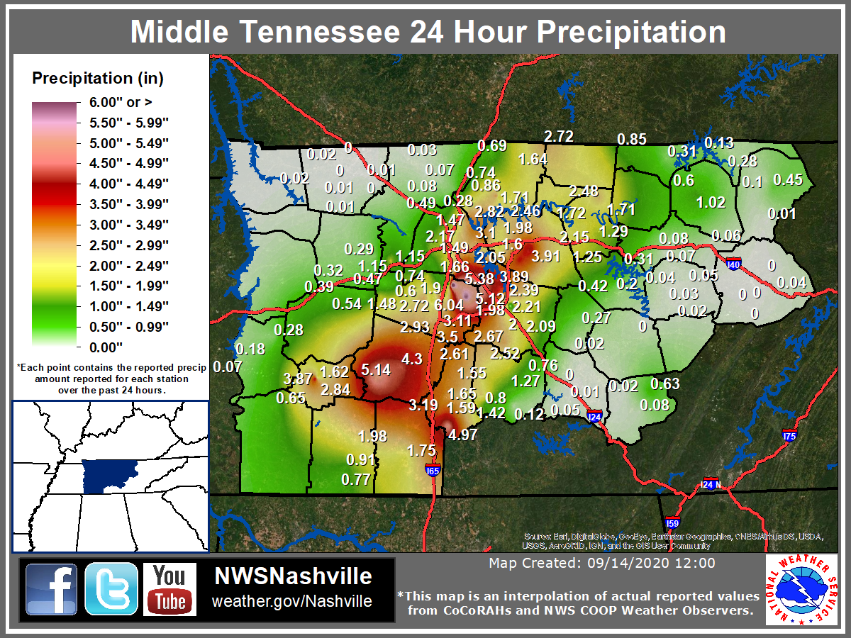 Middle TN 24 Hour Precipitation |
Flooding
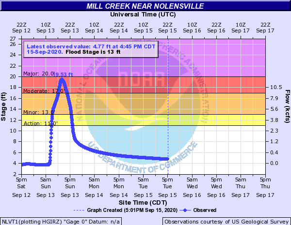
Hydrographs - Mill Creek
 |
 |
 |
| Mill Creek at Nolensville | Mill Creek at Antioch | Mill Creek at Woodbine |
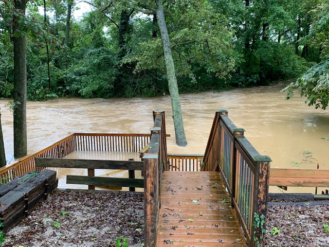
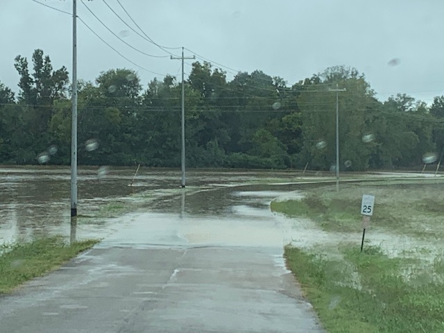
Photos & Video
 |
 |
 |
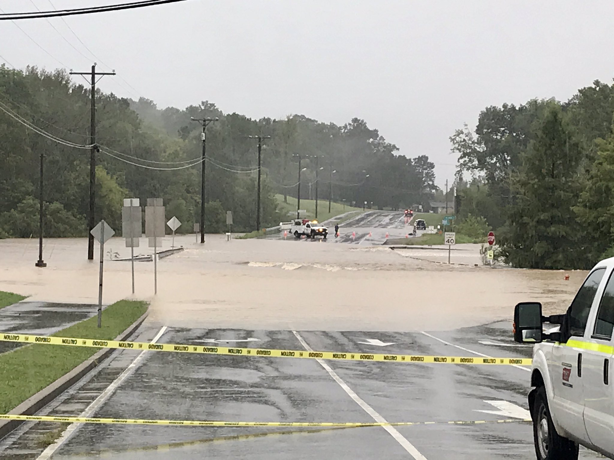
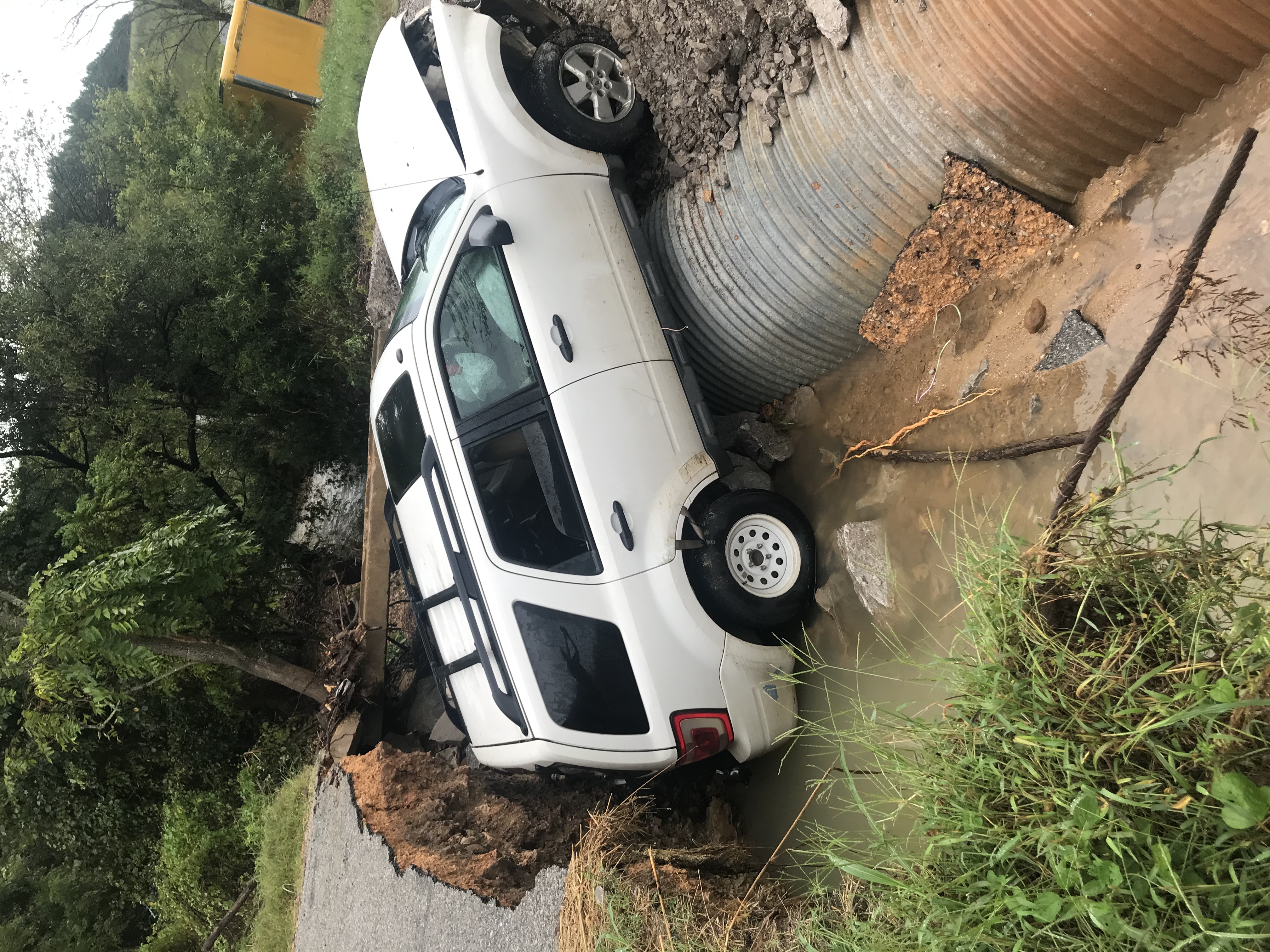
| Concord Road at Nolensville Pike in Nolensville (Brandon Baril) |
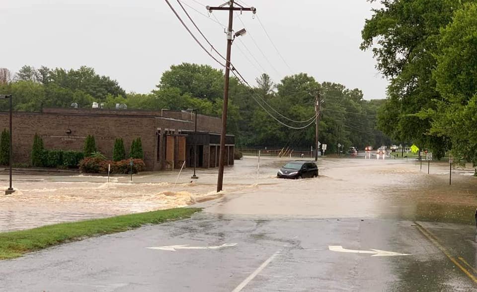
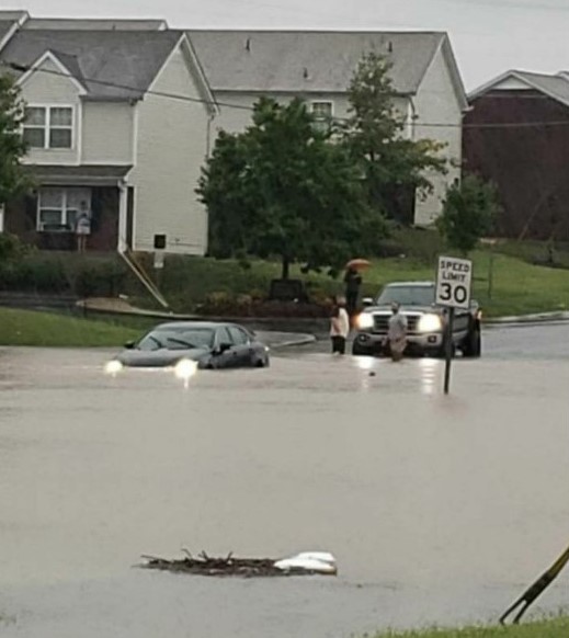
Nolensville, TN (Terry McBride) |
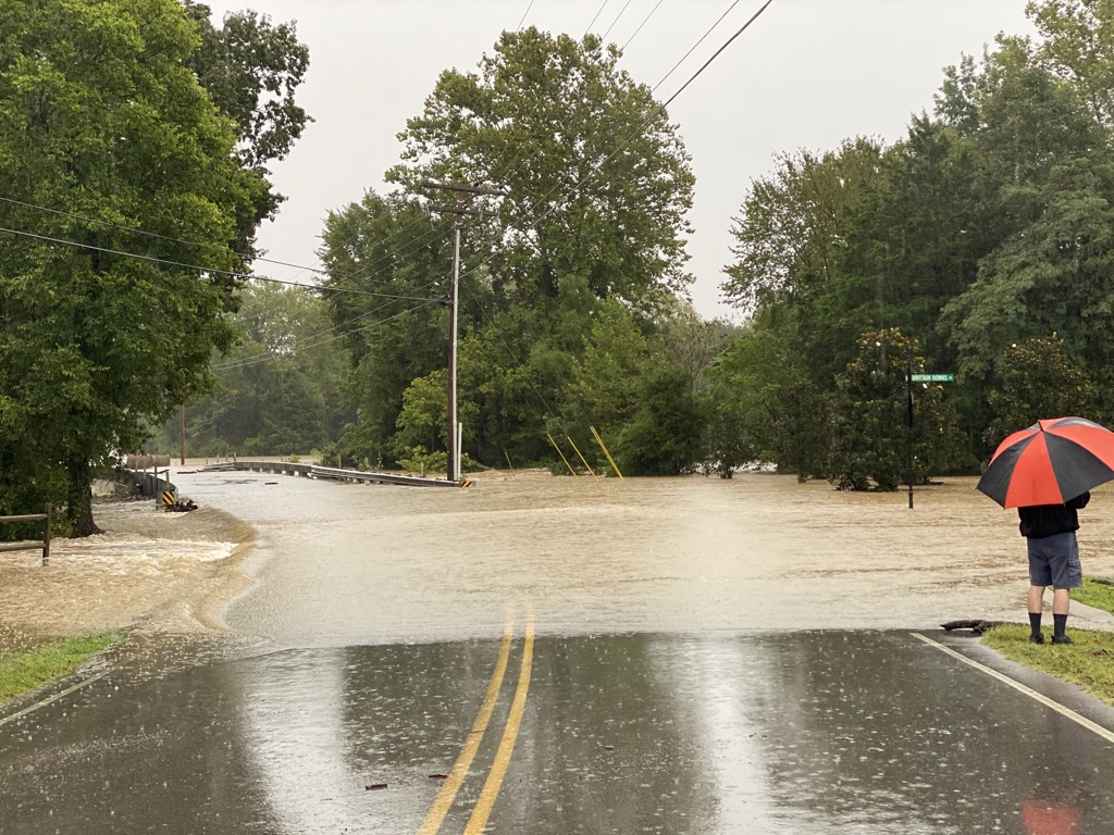
Brittain Lane near Nolensville (Aaron Luke) |
 |
 |
 |
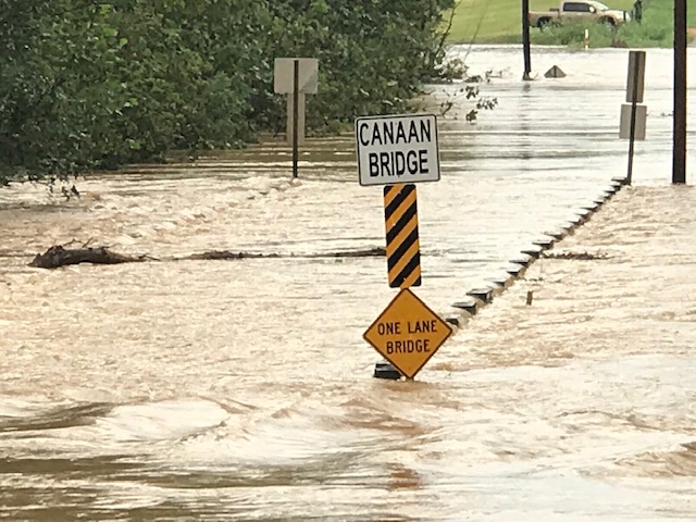
| Canaan Road at Ashwood Road in Maury County (Maury County EMA) |
Sugar Creek on Brookside Drive in Maury County (Maury County EMA) |
Magnolia Road in Mount Pleasant, TN (Maury County EMA) |
 |
.jpeg) |
.jpeg) |
| Anderson Creek Road in Lawrence County (Lawrence County EMA) |
Water rescue in Lawrence County (Lawrence County EMA) |
Water rescue in Lawrence County (Lawrence County EMA) |
 |
 |
 |
| Wolverine Trail in Smyrna (Brandon Curran) |
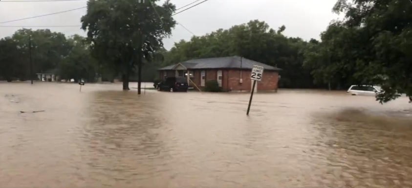
Dodson Chapel Road in Hermitage (Sarah Eggers) |
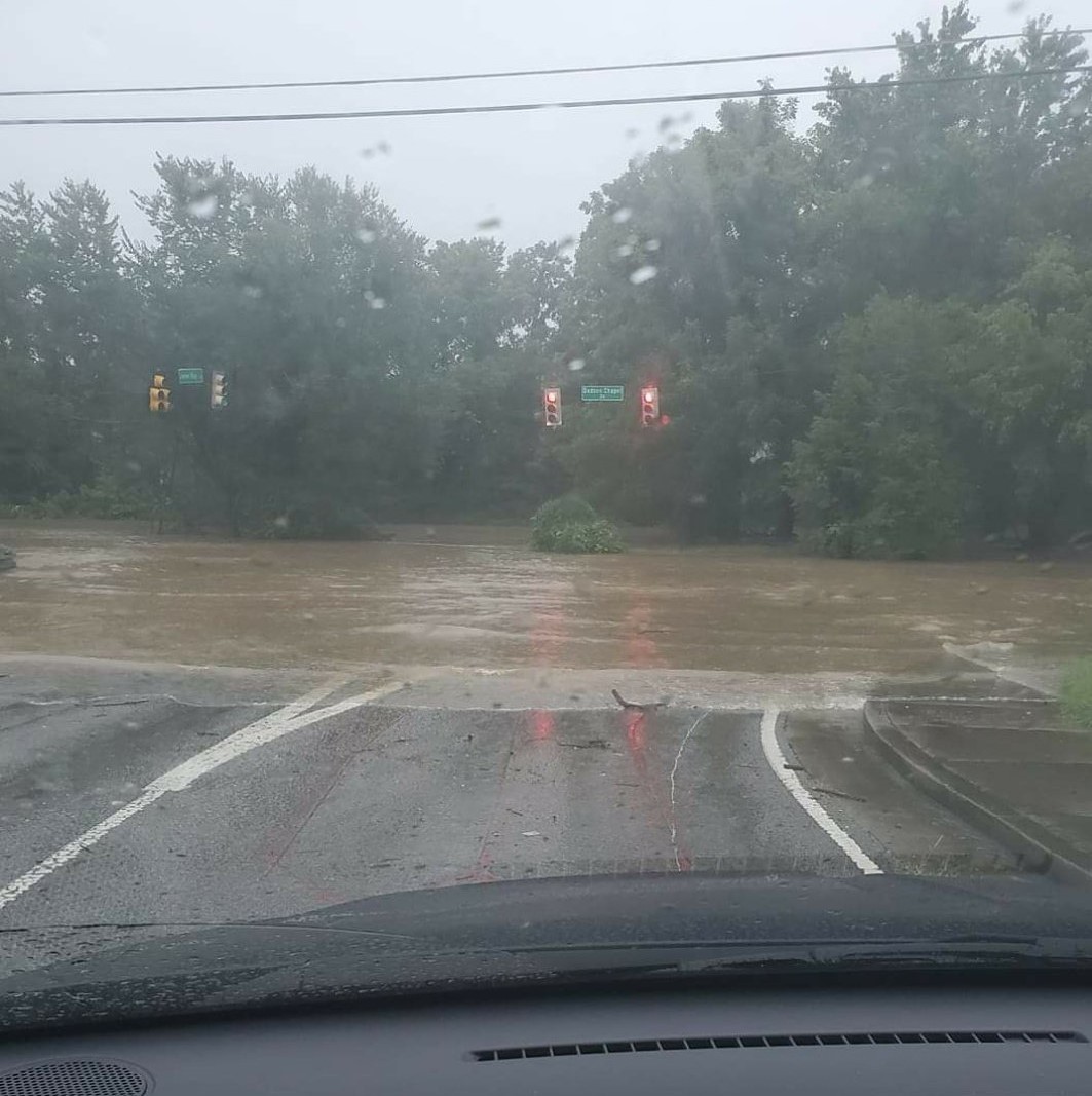
Santa Monica Blvd at Hollywood Blvd in Gallatin (WKRN-TV) |
Radar
| Radar imagery and total rainfall from September 13, 2020 |
Storm Reports
PRELIMINARY LOCAL STORM REPORT...SUMMARY
NATIONAL WEATHER SERVICE NASHVILLE TN
533 PM CDT TUE SEP 15 2020

..TIME...   ...EVENT...      ...CITY LOCATION...     ...LAT.LON...
..DATE...   ....MAG....      ..COUNTY LOCATION..ST.. ...SOURCE....
            ..REMARKS..

0815 AM     FLASH FLOOD      5 SE BRENTWOOD          35.95N  86.72W
09/13/2020                   WILLIAMSON         TN   LAW ENFORCEMENT

            WALLER RD CLOSED DUE TO HIGH WATER.

0845 AM     FLASH FLOOD      NOLENSVILLE             35.95N  86.65W
09/13/2020                   WILLIAMSON         TN   LAW ENFORCEMENT

            MULTIPLE ROADS FLOODED AROUND NOLENSVILLE.

0900 AM     FLASH FLOOD      3 SSW ANTIOCH           36.02N  86.69W
09/13/2020                   DAVIDSON           TN   EMERGENCY MNGR

            WATER RESCUE ONGOING AT CULBERTSON RD.

0929 AM     FLASH FLOOD      2 NE LA VERGNE          36.02N  86.55W
09/13/2020                   RUTHERFORD         TN   SOCIAL MEDIA

            WATER APPROACHING HOMES ON MERCURY DRIVE IN LA VERGNE

1000 AM     FLASH FLOOD      5 NE GALLATIN           36.43N  86.39W
09/13/2020                   SUMNER             TN   TRAINED SPOTTER

            DESHA CREEK IS OVER WRIGHTS LN AND THE ROAD IS
            IMPASSABLE.

1012 AM     FLASH FLOOD      SPRING HILL             35.74N  86.92W
09/13/2020                   MAURY              TN   TRAINED SPOTTER

            ROAD FLOODED AND CLOSED AT MILES JOHNSON PKWY AND
            DUPLEX RD

1015 AM     FLASH FLOOD      HENDERSONVILLE          36.29N  86.60W
09/13/2020                   SUMNER             TN   TRAINED SPOTTER

            OLD SHACKLE ISLAND RD CLOSED DUE TO FLOODING.

1018 AM     FLASH FLOOD      MOUNT PLEASANT          35.55N  87.19W
09/13/2020                   MAURY              TN   EMERGENCY MNGR

            SEVERAL ROADS BECOMING FLOODED AND ARE BEING CLOSED.

1037 AM     FLASH FLOOD      1 W MOUNT JULIET        36.21N  86.54W
09/13/2020                   WILSON             TN   LAW ENFORCEMENT

            OLD LEBANON DIRT RD CLOSED 1.5 MILES WEST OF MOUNT
            JULIET RD DUE TO HIGH WATER.

1041 AM     FLASH FLOOD      3 S GLADEVILLE          36.07N  86.42W
09/13/2020                   WILSON             TN   AMATEUR RADIO

            WATER IS THREE FEET DEEP AT THE INTERSECTION OF
            COUCHVILLE PK AND MCCRARY RD.

1048 AM     FLASH FLOOD      1 SSW LA VERGNE         35.99N  86.58W
09/13/2020                   RUTHERFORD         TN   TRAINED SPOTTER

            SIGNIFICANT FLASH FLOODING HAS MOVED AND FLIPPED
            SHIPPING CONTAINERS UP TO BRIDGESTONE PKWY.

1055 AM     FLASH FLOOD      1 SSE ANTIOCH           36.05N  86.67W
09/13/2020                   DAVIDSON           TN   DEPT OF HIGHWAYS

            I-24 CLOSED AT BELL RD DUE TO WATER OVER THE
            INTERSTATE.

1105 AM     FLASH FLOOD      2 N GALLATIN            36.41N  86.45W
09/13/2020                   SUMNER             TN   BROADCAST MEDIA

            WATER OVER THE ROAD AND APPROACHING HOUSES AT SANTA
            MONICA BLVD AND HOLLYWOOD BLVD.

1105 AM     FLASH FLOOD      4 SSW MOUNT PLEASANT    35.50N  87.22W
09/13/2020                   MAURY              TN   EMERGENCY MNGR

            MULTIPLE WATER RESCUES FROM HOMES AT WEST SHEEPNECK RD
            AND LAWRENCEBURG HWY.

1105 AM     FLASH FLOOD      COLUMBIA                35.62N  87.05W
09/13/2020                   MAURY              TN   EMERGENCY MNGR

            MULTIPLE ROADS FLOODED AND CLOSED IN COLUMBIA.

1145 AM     FLASH FLOOD      SUMMERTOWN              35.43N  87.31W
09/13/2020                   LAWRENCE           TN   EMERGENCY MNGR

            MULTIPLE WATER RESCUES ONGOING IN THE NORTHERN PART OF
            LAWRENCE COUNTY

1150 AM     FLASH FLOOD      CASTALIAN SPRINGS       36.39N  86.31W
09/13/2020                   SUMNER             TN   TRAINED SPOTTER

            WATER OVER THE ROAD AT ROCK SPRINGS RD AND ROGANA RD.

1152 AM     HEAVY RAIN       BRENTWOOD               36.00N  86.79W
09/13/2020  M5.25 INCH       WILLIAMSON         TN   AMATEUR RADIO

            5.25 INCHES OF RAIN MEASURED SINCE 7 AM AT CONCORD RD.

1200 PM     FLASH FLOOD      SUMMERTOWN              35.43N  87.31W
09/13/2020                   LAWRENCE           TN   SOCIAL MEDIA

            LAWRENCE COUNTY EM FB PAGE REPORTED NUMEROUS AGENCIES
            REPONDING TO HEAVY RAIN AND FLOODING THAT CONTINUED INTO
            SUNDAY AFTERNOON ACROSS NORTHERN LAWRENCE COUNTY.
            NUMEROUS TREES FELL FROM WATER AND AT LEAST ONE WATER
            RESCUE. OCCURRED.

1218 PM     FLASH FLOOD      LEBANON                 36.21N  86.32W
09/13/2020                   WILSON             TN   TRAINED SPOTTER

            HWY 231 CLOSED SOUTH OF THE LEBANON SQUARE.

0145 PM     FLASH FLOOD      MOUNT PLEASANT          35.55N  87.19W
09/13/2020                   MAURY              TN   EMERGENCY MNGR

            RECEIVED IMAGES FROM MAURY COUNTY EMA OF FLOODING.
            BRIDGE OVER BIG BIGBY CREEK AT THE CORNER OF CANAAN RD
            AND ASHWOOD RD FLOODED. MAGNOLIA RD IN MT. PLEASANT
            FLOODED. SUGAR CREEK IN MT. PLEASANT ALSO FLOODED.


&&

EVENT NUMBER OHX2000530 OHX2000531 OHX2000532 OHX2000533 OHX2000534
OHX2000535 OHX2000541 OHX2000536 OHX2000537 OHX2000538 OHX2000539
OHX2000540 OHX2000542 OHX2000543 OHX2000544 OHX2000546 OHX2000547
OHX2000545 OHX2000549 OHX2000548 OHX2000550


$$

Shamburger
Rainfall Reports
PUBLIC INFORMATION STATEMENT
NATIONAL WEATHER SERVICE NASHVILLE TN
433 PM CDT MON SEP 14 2020

...MEASURED RAINFALL FROM SUNDAY, SEPTEMBER 13TH...

HERE ARE SOME OF THE HIGHER MEASURED RAINFALL TOTALS WHICH CAUSED
SIGNIFICANT FLOODING AROUND MIDDLE TN ON SUNDAY MORNING. AMOUNTS ARE
IN INCHES:

LOCATION           AMOUNT          SOURCE

1.9 ESE BRENTWOOD  8.25            COCORAHS
LASCASSAS          7.45            TWITTER
NOLENSVILLE        7.03            FACEBOOK
2.4 SW NOLENSVILLE 6.04            COCORAHS
SARDIS             5.60            FACEBOOK
2.0 W NOLENSVILLE  5.53            COCORAHS
2.1 SW LAVERGNE    5.38            COCORAHS
MT. PLEASANT       5.14            OHX COOP
COLUMBIA           5.00            FACEBOOK

$$

27
 |
Media use of NWS Web News Stories is encouraged! Please acknowledge the NWS as the source of any news information accessed from this site. |
|

