Recommendations of the Water Resources Internet Mapping Team River Conditions
River Forecast Mapping National Weather Service River Forecast Center Development Management Team Table of Contents Executive Summary 4 Introduction 5 Internet Mapping Basics 5 A. What is Internet Mapping? 5 B. Example 6 C. How does IMS work? 8
Methodology 9 A. Survey 9 B. Research of Current Technology 9 C. Industry Leaders 10 Considerations 10 A. Hardware 10 B. Operating Systems 10 C. Browsers 10 D. Web Servers 11 E. Software Features 11 F. Data Access 11 G. Development 11 H. Performance 12 I. Accessibility 13 J. Maintenance and Support 13 K. Training 13 L. Software Costs 14 Connections with NOAA, NWS, USGS Efforts 14 A. Web Infrastructure team 14 B. GIS Business Plan 15 C. AHPS Products and Information Team 15 D. National Digital Forecast Database (NDFD) 15 E. Potential uses of IMS technology for water resources in the NWS 15 F. Activities in NOAA 16 G. United States Geological Survey (USGS) Activity 16 Recommendations 17 References and Contacts 19 Appendices 20 Appendix A - Water Resources Internet Mapping Team 20 Appendix B - NWS Water Resources Demonstration IMS Projects 21 Appendix C - Requirements Document 22 Appendix E - Requirements Comparison Chart 30 The Water Resources Internet Mapping (WRIM) team began work in September 2001 with the mission to explore the emerging Internet Map Server (IMS) technology field. They were to make a recommendation on the use of IMS in the National Weather Service for water resources applications. The team examined a wide range of Internet mapping applications and investigated the IMS technology they used. A requirements document was produced based on these investigations, input from field offices, and observations of current NWS water resource IMS demonstration applications. The team narrowed down the field of IMS providers to two industry leaders, Autodesk's MapGuide and Environmental Systems Research Institute's ArcIMS, for further investigation. The team makes the following recommendations based on their research:
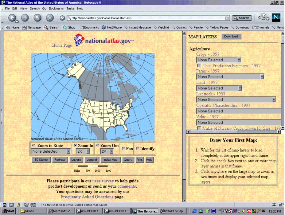
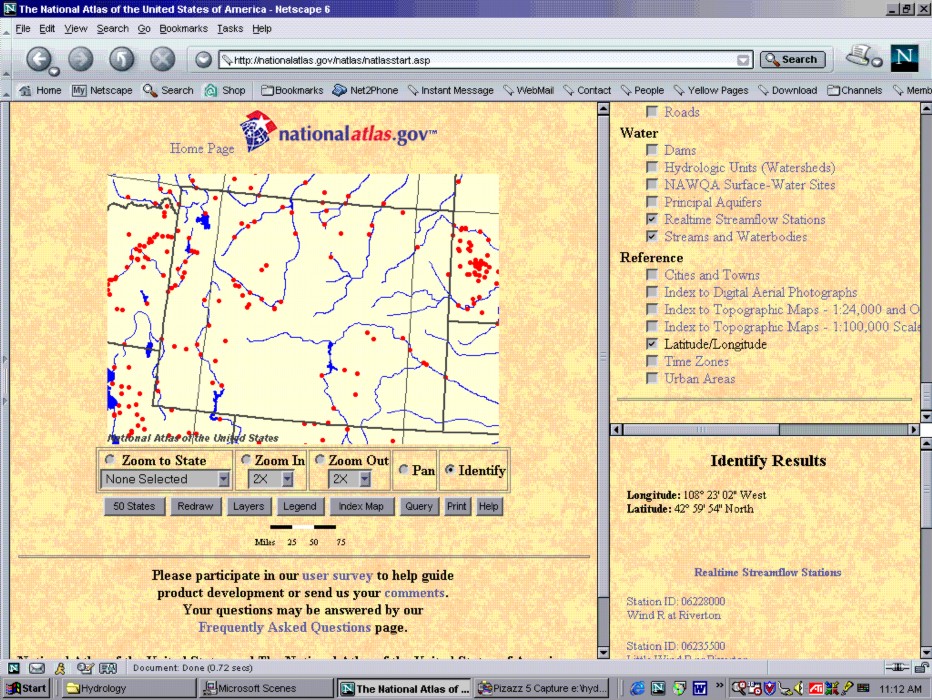
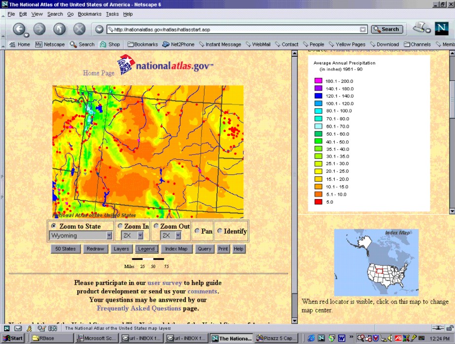
This report to the National Weather Service (NWS) Corporate Board contains a recommendation for a corporate approach to water resource Internet mapping. A coordinated NWS plan will ensure a coherent and cost effective strategy is implemented for the optimal use of NWS resources in serving location dependant or georeferenced information on the Internet. Most of the information the NWS uses and its customers look for is location dependent. One way to make this information available is to develop custom static maps with the information needed by each user. An alternative is to use the very powerful, emerging Internet Map Servers (IMS) technology. Internet mapping is the foundation for distributing and disseminating georeferenced information on the world wide web. The IMS technology not only allows for efficient mapping utilities, it enables a common foundation and collaborative environment for the exchange and sharing of resources through data streaming and data download. It truly provides the opportunity to manage data from within an organization as well as a platform to exchange data with NWS customers and integrate data from other agencies. This recommendation was generated by the Water Resources Internet Mapping (WRIM) team (Appendix A). The team was formed in September 2001 under the RFC Development Management process as a result of the interest generated by several prototype IMS projects for NWS water resources (Appendix B). The team has concluded that IMS technology will allow the NWS to deliver better products and services while capitalizing on scientific and technological advances in Internet communications. Internet mapping is the ability to provide georeferenced information on a map on the World Wide Web. The map may have several thematic layers containing different types of data. These maps are dynamic and easily customized. The user is able to zoom in to their area of interest and choose which data to display. Users may cut and paste their custom maps and associated data into other applications for their own use. IMS applications can be made available on intranets, the Internet, and on hand-held devices. Potential NWS water resource applications include mapping precipitation estimates (both gridded and point), snow data, river conditions, drought and water supply information, and forecast flood innundation areas. These maps can be used at a single RFC or WFO site for quality control, for collaboration between RFCs, WFOs, NCEP, regional, or national headquarters and NWS partners, or for providing information to all NWS customers. A summary of NWS prototype water resources IMS applications is contained in Appendix B. The following example shows some of the power of Internet mapping by highlighting the National Atlas website developed by the United States Geological Survey (USGS) and the Forest Service. The first figure shows the initial view a user sees upon entering the website (http://nationalatlas.gov) with the view of entire area for which data is available. The second shows the map after zooming into an area and adding two data layers (streamflow stations and water bodies). The bottom right section also shows the results of a query about the location clicked on by the user. The results are for all the current map layers. The third figure shows the addition of the average annual precipitation data. It features the legend for the precipitation data on the right side. Many other features can be made available on IMS sites, including data download. The power to customize a site and provide various types of information in various forms from multiple data sources is almost limitless.
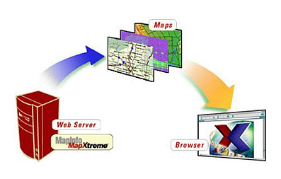
Internet map serving software has two main components. The first is a geospatial data processing engine running on a server to gather and process raw spatial data into a map. The second is a standard web server to manage incoming requests, send them to the engine, and transmit the replies with the requested map data back to the client browser or viewer window (Bohnenstiehl 2002). From www.mapinfo.com - http://dynamo.mapinfo.com/miproducts/attachments/screenshots/mapxtreme_whatis_image1.jpg
A key element in defining requirements for an organization-wide internet mapping solution is evaluating the benefit of internet mapping to the current geospatial applications within the NWS. One of the first tasks of the WRIM team involved surveying their respective regions to identify the water resource applications that would benefit from, or be developed as a result of, the availability of an internet mapping solution. These regions were also polled to ascertain the "must haves" in such an application. A challenge encountered by the team in getting feedback from the field offices was that most were not familiar with this emerging technology and had little or no experience to draw on. To gain more information, feedback was also collected from a concurrent study conducted by the River Mechanics group of the Hydrology Laboratory in the Office of Hydrologic Development (OHD). This study involved two demonstration applications, developed by a private contractor, which displayed flood inundation maps using two leading internet mapping software solutions, ESRI's ArcIMS and Autodesk's MapGuide. Participants in the study were given 29 identical tasks to complete in both applications. Upon completion, they were asked to rank the tasks from 0 to 5 where 0 indicates that the task could not be performed, 1 indicates the task was performed easily, and 5 indicates that the task was difficult. Participants were also asked to list the top four most and least important requirements in an internet mapping application. Special consideration was also given to the following NWS demonstration projects detailed in Appendix B:
All of these activities were monitored throughout the recommendation process, and performance observations, including suggestions for improvement, were incorporated into the pool of feedback. B. Research of Current Technology All survey results, feedback, and observations were compiled, and a list of requirements was developed with the following categories: Dynamic Functionality, Structural Functionality, Performance, Interface, Operational Display, Operational Query, Resources, Documentation, Safety, Reliability, Maintainability, Accessibility, and Training. These categories served as focal areas in our research of current internet mapping technology vendors. The requirements are provided in Appendix C. Research of current technology yielded four major internet mapping solutions: Autodesk MapGuide, ESRI ArcIMS, Mapinfo MapXtreme Java Edition, and University of Minnesota's MapServer (a free IMS). Of these four products, there were two clear frontrunners, ESRI ArcIMS and Autodesk MapGuide. Their status as frontrunners was based on observed instances of implementation, current applications in use, and their ratings in the selection categories mentioned previously. Both vendors were supplied with sample precipitation data from team member Frank Bell of the Southern Region, and given the opportunity to present their product to the WRIM team and other interested NWS parties. Both vendors accepted the invitation to demonstrate their products, and held presentations at NWS headquarters in Silver Spring. Autodesk simultaneously held a webcast of their presentation for team members in the field. Both vendors successfully demonstrated their ability to serve the provided data and accomplish all requested tasks using their respective applications. They were also both successful in demonstrating future ability to handle most of the needs expressed as "must haves" throughout our data collection process. There were many factors the team investigated for ArcIMS and MapGuide. The hardware, operating system, browsers, and web server information is detailed in Appendix D and summarized here. Information is based on MapGuide Version 6 and ArcIMS 4.0 (released in early May 2002). Both ESRI's ArcIMS and Autodesk's MapGuide run on PC-Intel Pentium machines. ArcIMS also runs on IBM, Sun, and HP workstations. Both ArcIMS and MapGuide fully support Windows 98, 2000, and NT 4.0 operating systems. Both are developing full support for the Windows XP operating system. In addition, ArcIMS is also available for Linux, IBM-AIX, Sun Solaris, and HP-UX operating systems. The Linux platform is new with this version of ArcIMS. Both ArcIMS and MapGuide fully support the latest 5.x version of the Internet Explorer (IE). ArcIMS 4.0 will support IE 6.0 and MapGuide hasn't posted information on 6.x yet. MapGuide provides support for 4.x versions of Netscape. ArcIMS only supports server side applications on Netscape - its Java Custom Viewer plugin will not work with Netscape. ArcIMS is fully compatible with Apache, IBM HTTP, IIS, iPlanet, and Oracle Application Server web server software. ArcIMS has limited compatibility with the WebLogic web server. MapGuide is fully compatible with IIS, Netscape Enterprise Server and iPlanet web server software. The software features in ArcIMS and MapGuide are very similar. Both packages can work out-of-the-box, but also allow for customizing and extending features via server side programming. Clients are able to click on and off the desired data layers easily in both packages. Both packages offer a variety of user-friendly tools for zooming and panning, some query capabilities, and cartographic tools for map generation. Both support a wide variety of data formats and can connect to relational databases using the Open Database Connectivity (ODBC) specification. Please refer to Appendix E for specific software features related to, and unique to, ArcIMS and MapGuide. One of the main capabilities of IMS technology is the ability of the user to access various data layers available to the application using the point and click of a pointer device. This allows users to customize the map for the area of interest with the data of interest to produce just the map they want. These capabilities are available in all IMS products. In addition, applications can allow users to query the underlying data by accessing data stored in the data files used to produce the maps or located in relational databases or other files on local or remote servers. These capabilities are easily programmed into the applications for both the MapGuide and ArcIMS products. The resulting data from the query may be cut and pasted for users other needs. In addition, the data may be directly imported into other applications. For example, shapefile data from ArcIMS sites may be directly imported into ArcGIS clients. Application developers in either program may make other data download capabilities available - they may write applications that allow for download in various formats. Application development can range from simple (but powerful) out-of-the-box authoring given product supplied tools requiring little or no programming experience to sophisticated development requiring programming skills and/or use of third party web authoring products. There are generally 3 steps in the development of out-of-the-box applications for both MapGuide and ArcIMS. The first step is use of an authoring tool that allows users to choose the data sources and set up the look and feel of the map. The second step involves setting up the map service on the web server. The third step is to build the website to serve the map. Both products contain easy-to-use graphical tools to do the first two steps. ArcIMS also has a tool to build the website. Development of highly customized IMS sites with advanced features requires programming in languages like Java, JavaScript, JScript, Visual Basic, or VB Script to take advantage of the features in the viewer plug-in required by these sites. Also, custom clients can be built in HTML or using third party software such as Active Server Page (ASP), ColdFusion, or Java Server Pages (JSP). Development should take into consideration the target users needs and resources. There are 2 main ways applications can be developed - server based or client based. They each have implications for the end users and for performance of the server machines and applications themselves. In server side applications, the web server processes requests from users and sends the requested information back in the form of a JPEG or GIF image. These applications are generally simpler, require few resources from the users computer, and are able to run on a wide variety of browsers and operating systems. They do not require an additional plug-in for the end users' browser. Because they transmit back only an image, the only offer basic features like zoom, pan, and basic vector attribute query. In client side applications, the web server processes requests from users and sends back a stream of data to the client computer that is interpreted by a required plug-in to the client browser. This allows much of the processing to happen on the user computer without having to go back on the network and the plug-ins allow for advanced features. Plug-ins may not be available for all browsers or operating systems. The ArcIMS allows for development of either client side or server side applications. Client side applications require a Java plugin that is available for most operating systems and but only the IE browser. Autodesk offers different products for client and server side applications. MapGuide allows for only client side application development. The MapGuide plugin is available for Windows, Mac, or Solaris (Unix) operating systems. There are no plugins available for HP-UX or Linux and attempts to install the Solaris plugin in these environments were unsuccessful. Autodesk also offers a MapGuide LiteView product to create server side applications. Performance of applications can vary widely. It is dependant on many factors including server and client hardware, network speed, and the application. In general, client side applications perform faster after the initial download of data if the user is performing a lot of map manipulation. In many cases, server side applications perform as fast as client side depending on network speed and how busy the web server is. One of the considerations for NWS sites is that often the most use is in times of severe weather when the web servers are busiest. This will need to be balanced with the need to reach most of the NWS users. Both vendors publish guidelines on maximizing performance - both for the hardware and the applications. Both can perform what is termed load balancing - spreading out incoming user requests among several map servers so no one machine gets overloaded. The NWS is required by law (referred to as Section 508 of the Rehabilitation Act) to ensure the software they procure and the information they make available is accessible to all users. We need to ensure the product is Section 508 compliant and websites developed for Internet mapping will be compliant. ESRI has statements on their products Section 508 compliance on the website http://www.esri.com/legal/section508/common-questions.html. They state that ArcIMS is compliant with minor issues ("ArcIMS does not use local user accessibility settings."). In addition, the company's policy on accessibility and Section 508 is available at http://www.esri.com/software/section508/position.html. We have not yet received a Section 508 compliance statement from Autodesk. Maintenance and support of the selected IMS is important to the successful implementation of applications and their long term support. ArcIMS comes with a 1 year maintenance and support agreement. This allows access to telephone support and to software upgrades. Maintenance contracts are available for a fee after the initial year. MapGuide maintenance and support is available for a fee. Costs for both MapGuide and ArcIMS support are detailed in section L. below. In addition to traditional telephone support, both MapGuide and ArcIMS offer free online support from their web pages. Some of the features include a searchable database of questions and answers, discussion groups, and code examples for download. These services can be valuable sources of information - especially for developers. Another issue with maintenance and support will be in the implementation of IMS applications. The IMS software and applications will most likely be hosted on the current region based web servers. This will result in an additional load on the web servers and those that administer them. Training is an important requirement for an NWS IMS. There is currently very little knowledge in the NWS on developing applications or administering the websites so training will be required. Autodesk provides training for MapGuide through their authorized training centers located around the country. We have contacted one of Autodesk's vendors, Isosceles Information Solutions. They offer 2 courses in MapGuide (Introduction and Advanced) along with custom training. The custom training is about $650/day. Autodesk also offers several 1-2 hour online courses available on selected MapGuide topics. These courses can be obtained for about $15 per topic. ESRI also has an extensive training network. It offers 4 courses aimed at ArcIMS users (introduction, administration, customizing with ArcXML, and customizing with HTML and JavaScript). Courses are held around the country and the current schedule is available on their website. Courses generally run 2-3 days and cost about $450 per day (i.e. a 2 day course is $900). Both Autodesk and ESRI will also arrange for custom courses to be given at a users site if they have a certain number of participants. These are often arranged at a discount from the cost of the regularly scheduled courses. Software costs were not initially considered by the team other than to confirm they were in the same ballpark. GSA software costs for these products are presented here. Our investigation has found that several MapGuide modules are needed to cover our requirements. They are listed separately. ArcIMS will cover our requirements as packaged. Recurring Total Initial Product Cost ($) Support ($/year) Cost ($)
Notes: 1Adding MapGuide software for server side applications will require 1 additional modules at a cost of $1200 ($1376 with support). 2Prices will be 4% lower than GSA price listed as negotiated in a NOAA blanket purchase agreement with ESRI. 3ArcIMS includes one year of support with purchase
Once obtained, the software can be used to develop, deliver, and support as many applications as the server can handle. Down the road, most of the costs will be for the hardware and people to develop and maintain the applications. These costs will need to be evaluated by a follow-on team. Connections with NOAA, NWS, USGS Efforts The team has discussed the direction of the team looking at the NWS web infrastructure with Robert Bunge of the NWS Chief Information Officer's office. The current state of the regional web servers in the contiguous US is that all are now running on Linux or UNIX machines (one region is just transitioning) with Apache web servers. This will likely be the same in the future. In addition, they support the development of websites using open source technologies over proprietary ones (i.e. Windows/IIS/ASP). A GIS business plan is being developed for the NWS by Roger Shriver of OST. A draft of the plan was provided to a team member. It reveals that there is widespread use of the ESRI GIS products (ArcView and ArcInfo) at WFOs, and RFCs. These GIS products can produce shapefile format data that can be served by either MapGuide or ArcIMS servers. In addition, data can be directly downloaded from ArcIMS sites for use in the ESRI GIS clients or could be provided for download in shapefile format by either MapGuide or ArcIMS applications. C. AHPS Products and Information Team The WRIM status was presented to the AHPS Products and Information Team during their meeting in Silver Spring in February. They were introduced to the IMS technology as a mechanism they could consider for getting AHPS information to the public. They saw a demonstration of the River Conditions ArcIMS website developed by OCWWS HSD and OST and the Flood Innundation Mapping (FLDIMS) MapGuide website developed by a contractor for OHD. D. National Digital Forecast Database (NDFD) The NDFD will contain gridded forecast information of many meteorologic parameters of interest to NWS partners and cooperators. The NDFD is still being developed but we have had discussions with some of the developers about the use of IMS technology to provide the gridded data to the end users. They have provided some information on systems they are considering - the WWW Image Processing Environment (WIPE) and NOAA Operational Model Archive and Distribution System (NOMADS). E. Potential uses of IMS technology for water resources in the NWS Information provided by Tom Dietrich of OCWWS/HSD lists possible uses of IMS for water resources NWS . The list includes: 1) Quality control of location information (i.e. latitude/longitude for Coop Stations) 2) Access data and forecasts for specific locations (e.g. SNOTEL plots) 3) Topography can be introduced into the information that is available 4) Data/Forecast overlays can be made very easily (e.g. HADS data locations + Forecast Points) 5) Provide Flash Flood information to NWS forecasters and customers 6) General mapping of Flash Flood Prone areas 7) Evaluate Flash Flood Guidance and make adjustments as needed. 8) Site Specific Forecasts 9) Soils/Geology mapping to evaluate runoff (e.g. flash flood as well as general flooding) 10) Precipitation Distribution / Accumulation 11) Snow Distribution / Accumulation 12) Mapping of Forest Fire burn areas 13) River Gage/HADS locations for geographic coverage, etc 14) Flood plain information (e.g. inundation mapping) 15) Dam locations and information Note: Tom also provided graphic and pictures for each but in the interest of space they were not included. There are numerous IMS activities within NOAA. In the NOAATECH 2002 Workshop and Expo in October, 2001 (www.noaatech2002.noaa.gov) there were four IMS projects presented. In addition, Ted Habermann of National Environmental Satellite Data Information Service (NESDIS)/National Geophysical Data Center organized a December 7, 2001 videoconference of 6 presentations from 3 NOAA line offices (NWS, NESDIS, and National Ocean Service). The videoconference was widely attended by those interested in IMS. All groups were using ArcIMS mainly as a result of their work with ESRI GIS products. Recent emails on the geospatial mailing list indicate both NOS and NESDIS are developing some reusable code for ArcIMS web viewers. G. United States Geological Survey (USGS) Activity The USGS has embarked on many projects using IMS technology. A November, 2001 report discusses their vision to create a The National Map, a database of continuously maintained geographic data to serve as the Nation's topographic map for the 21st century (USGS, 2001). Part of the report discusses their planned use of IMS technology to provide the data to the public: "The USGS is committed to ensuring that The National Map content remains in the public domain and is made accessible over the World Wide Web through multiple Web-based services, including an image service (Web mapping), feature services (data streaming in support of location-based services and metadata browsing), and data extract (feature access and spatial data transfer). All services will use industry-supported, open, standards-based protocols, as appropriate, to allow these data to be accessed easily and readily, for maximum utility to all users. Unrestricted and immediate access to The National Map is of vital importance to public and private organizations for emergency and disaster response. To ensure access for these and other critical needs, The National Map will be designed with redundant servers, sufficient bandwidth, and around-the-clock operational support." (USGS, 2001) The
WRIM team, after careful consideration of the factors involved with
Internet Map Server technology makes the following conclusions and
recommendations: 1. Internet mapping will allow the NWS to deliver better products and services to it's customers by capitalizing on scientific and technological advances in Internet communications. It can begin to move the NWS from delivering products to delivering information. The NWS can concentrate on creating the best information and allow the customers to determine what the best view of the information is for them. It will also facilitate exchange of information with other agencies, emergency managers, etc. who are using similar IMS and GIS technology. 2. To implement a coherent and cost effective strategy, the NWS should use one IMS product. This will provide a common software development environment, standardize operations, and minimize maintenance and support issues. 3. The WRIM team recommends the use of the ArcIMS software for the NWS standard for water resources internet mapping based on an analysis of the requirements comparison chart (Appendix E). The team found both IMS products they evaluated in depth to have very comparable features and capabilities. Either one could be used to create the water resources applications considered at this time. As industry leaders, these two competing products will probably continue to offer similar features. The main difference came down to the availability of the product for the operating systems and web servers currently (and for the foreseeable future) being used by the NWS in their regional web serving environments. Additional factors in the recommendation of ArcIMS were:
4. The WRIM team recommends a follow-on team develop a full NWS implementation plan. The team should include experienced IMS developers and web hardware and software experts. IMS activity will have impact on the resources (people, hardware, and software) needed to administer and monitor the sites and will increase the traffic on the web servers. This activity must be fully supported. Web support teams should have training on administering IMS sites. 5. Until the implementation details are determined by the follow-on team, the WRIM team suggests the IMS software reside at the regions and/or NCEP and connect to the current NWS web server farms. NWS web server use would increase gradually. As applications were developed and hosted, the access rates would be monitored to help determine the resources necessary to provide the optimal service. This information would be valuable to the follow-on team. 6. The ability to develop simple applications should be available to all. If each region had a copy of the IMS software, the authoring tool should be available through remote access. In addition, when more sophisticated regional or national applications are required, a team of dedicated developers (either NWS or contractor services) should be available. There is currently a small group in OST that has experience developing applications for ArcIMS. This might be expanded and a mechanism created for requests to be handled and solutions tested before deployment. References Bohnenstiehl, Kyle, March 2002, The Power of Internet Mapping, GISVision http://www.gisvisionmag.com USGS, November 2001, The National Map: Topographic Mapping for the 21st Century http://nationalmap.usgs.gov/report/national_map_report_final.pdf Contacts NOAA/NWS OCWWS/HSD Frank Richards, Tom Dietrich OST Paula Kingsley, Roger Shriver, Dave Ruth Office of the CIO Robert Bunge AHPS Products and Information Team - Gregg Rishel NOAA/NESDIS NGDC Ted Habermann USGS John Costa - Portland, OR Joseph Jones - Tacoma, WA Autodesk Kevin Faus John Sullivan Joe Travis ESRI Ryan Bannon Mark Long Dan O'Neill Isosceles Information Solutions Brian Rizzo Appendix A - Water Resources Internet Mapping Team Thomas Adams Ohio River Forecast Center Andrea Bair Western Region Hydrologic Service Division (HSD) Frank Bell West Gulf River Forecast Center Michael Logan Office of Hydrologic Development - Hydrology Laboratory Ira Graffman Office of Science and Technology Donna Page Office of Hydrologic Development Wendy Pearson Central Region HSD
Consultant to the team: Tom Carroll Office of Climate, Water, and Weather Services National Operational Hydrologic Remote Sensing Center
Appendix B - NWS Water Resources Demonstration IMS Projects The projects listed here are all being served from a OCWWS-HSD machine at NWS Headquarters (HQ).
1. 24 hour Cooperative Precipitation Estimates for West Gulf River Forecast Center (WGRFC) This was a project started at WGRFC by Frank Bell. They had earlier developed a web application to show these data. It allowed for one overall picture and one level of zoom. To support this, they needed to generate 262 jpeg files a day. By using IMS (ArcIMS) technology, they now only need to generate one data file a day (or whenever they want to update) to send to the server machine at NWS-HQ. The application now allows users to zoom to any level. The website is found at: http://140.90.22.241/website/coopprecip/viewer.htm 2. Flood Forecast Mapping (FLDIMS) This OHD/Hydrology Laboratory (HL) project led by Janice Sylvestre has worked with a contractor, Isosceles Information Solutions Inc. to develop a web-based mapping application as part of the flood forecast mapping project. After a prototype evaluation of MapGuide and ArcIMS versions, MapGuide was chose for demonstration project. The project uses output from the HL developed FLDVIEW, the flood forecast mapping application, using ESRI's Arcview software with the 3-D Analyst and Spatial Analyst extensions. It is currently applied to the Juniata River in the vicinity of Lewistown, PA . The web-based application allows the user to view the flood raster and manipulate it without needing to purchase the ArcView software or needing to understanding ArcView The prototype website is at http://140.90.22.51/fldims.htm. 3. River Conditions The River Conditions application provides a national overview of river conditions and an ability for the user to focus on areas of interest. The description below is from the website (http://140.90.22.241/website/RiverConditions/viewer.htm) In addition to the map-based presentation, a user can also obtain information about current conditions at specific locations along the Nation's rivers (e.g., flood stage, current stage, and, when available, a hydrograph), as well as current flood warnings, river forecasts and other hydrologic statements issued by NWS Forecast Offices. The approach used in this prototype does not require the user to know which NWS office provides information of interest -- simply navigating using geographic references is all that's needed. This application is being developed by Ira Graffman and Paula Kingsbury of OST to the specifications set by Frank Richards of OCWWS-HSD. Feedback is being solicited from a fairly large (~300) and diverse set of users. Appendix C - Requirements Document Internet Map Server (IMS) Requirements The Water Resources Internet Mapping (WRIM) team is using the following requirements categories that were originally developed by the European Space Agency. The explanation of the categories comes from their documentation. 1. Functional Requirements Functional or behavioral requirements are used to consider system behavior, redundancy, human aspects and trade-offs between issues, weighing the benefits of each. Behavioral requirements, as well as describing how the system will operate under normal operation should also consider the consequences and effects of software failure or invalid inputs to the system. Note: For the Internet map server , Functional Requirements are divided into 2 subcategories: Functional Requirements (Dynamic) - description of system behavior Functional Requirements (Structural) - description of data structures to serve 1.1 Dynamic (FD) FD-1 Provide the features in the map displays including but not limited to: 1. zoom in/out 2. pan 3. add/subtract layers 4. print 5. cut/paste image 6. open attribute tables 7. query 8. identify 1.2 Structural (FS) FS-1 Allow for serving data in the following formats: 1. ESRI shapefiles 2. gridded files 3. Other raster formats (i.e. jpeg, gif, tiff, png, etc.) 2. Performance Requirements All performance requirements must have a value which is measurable and quantitative, not a value which is perceptive. Performance requirements are stated in measurable values, such as rate, frequency, speeds and levels. The performance values are based either on values extracted from the system specification, or on an estimated value.
Note: Map server performance is dependant on many factors: the application (client side/server side), how the IMS is implemented (server hardware, number of servers, etc.) , users network connection, and network traffic at time of the requests. Because of this, we don't have any quantitative requirements. These factors should be taken into account at development time. 3. Interface Requirements Interface requirements are handled separately, with hardware requirements being derived separately from the software requirements. Software interfaces include dealing with an existing software system, or any interface standard that has been requested. Hardware requirements, unlike software give room for trade-offs if they are not fully defined, however all assumptions should be defined and carefully documented. Note: For the Internet map server , Interface Requirements are focused on interaction with existing operating systems and web browser tools. IN-1 Applications developed must run in standard web browsers (Netscape, Internet Explorer) IN-2 Applications developed must run on standard operating systems (Unix, Linux, Microsoft Windows, Macintosh) IN-2 any needed plugins must be available for standard operating systems and web browsers 4. Operational Requirements Operational requirements give an "in the field" view to the specification, detailing such things as: how the system will operate, what is the operator syntax, how the system will communicate with the operators, how many operators are required and their qualification, what tasks will each operator be required to perform, what assistance/help is provided by the system, any error messages and how they are displayed, and what the screen layout looks like. Note: For the Internet map server , Operational Requirements are divided into 2 subcategories: Operational Requirements (Display) - description of Graphical User Interface Operational Requirements (Query) - description of data Queries needed 4.1 Display OD-1 Features should be easy to use (zoom, pan, add layers, access attribute tables) OD-2 Intuitive OD-3 Accessibility 1. Allows for development of Section 508 compliant applications 2. Software is Section 508 compliant OD-4 Allows for development of applications with capabilities such as: 1. select time frame 2. select product type 3. select period of accumulation (i.e. daily, monthly) 4. select output format (i.e. jpeg, shef) 4.2 Query OQ-1 ability of applications to query local and network data sources for information to build maps (including relational databases and other data files) OQ-2 ability of user to query help system for basic help on use of the tool OQ-3 ability of user to query application for map layer data 5. Resource Requirements Resource requirements divulge the design constraints relating to the utilization of the system hardware. Software restrictions may be placed on only using specific, certified, standard compilers and databases. Hardware restrictions include amount, percentage or mean use of the available memory and the amount of memory available. Note: For the Internet map server, Resource Requirements focus on the existing NWS web servers, operating systems, RS-1 Must work with existing NWS web servers 1. Apache 2. MS IIS RS-2 Should run on machines with operating systems used for NWS web servers 1. Linux 2. Unix 3. Windows NT RS-3 Should be able to develop server side and client side applications 6. Verification Requirements Verification requirements take into account how customer acceptance will be conducted at the completion of the project. Verification requirements specify how the functional and the performance requirements are to be measured and verified. The measurements taken may include simulation, emulation and live tests with real or simulated inputs. Note: For the Internet map server , no verification requirements have yet been identified. 7. Acceptance Testing Requirements Acceptance test requirements detail the types of tests which are to be performed prior to customer acceptance. These tests should be formalized in an acceptance test document. Note: For the Internet map server, Acceptance Testing Requirements will be defined at a later date. 8. Documentation Requirements Documentation requirements specify what documentation is to be supplied to the client, either through or at the end of the project. The documentation supplied to the client may include project specific documentation as well as user guides and any other relevant documentation. Note: For the Internet map server , Documentation Requirements focus on the types of documentation that must be provided. DO-1 Installation and system documentation will be provided DO-2 Developer documentation will be provided 9. Quality Requirements Quality requirements will specify any international as well as local standards which should be adhered to. Note: For the Internet map server, Quality Requirements focus on use of standards.. QU-1 Should use industry supported, standards based protocols 10. Safety Requirements Safety requirements cover not only human safety, but also equipment and data safety. Human safety considerations include protecting the operator from moving parts, electrical circuitry and other physical dangers. Equipment and data safety includes safeguarding the software system from unauthorized access either electronically or physically. Note: For the Internet map server , Safety Requirements focus on security issues. SA-1 The IMS will have security features to protect the hardware. SA-2 The IMS will have security features to protect the data. 11. Reliability Requirements Reliability requirements are those which the software must meet in order to perform a specific function under certain stated conditions, for a given period of time. Note: For the Internet map server , Reliability Requirements are at least partially dependant on the hardware and implementation of the server. No quantitative numbers at this time.
12. Maintainability Requirements Maintainability requirements look at the long term life of the proposed system. Requirements should take into consideration any expected changes in the software system, and any changes to the computer hardware configuration. Note: For the Internet map server , Maintainability Requirements focus on software support, upgrades and training. MA-1 The IMS will offer support services including: 1. direct contact (phone, email), 2. mechanism to interact with other developers, and 3. ability to download code examples. MA-2 The IMS will be a maintained software package with upgrade plans MA-3 The IMS will have bug report/fix mechanism. MA-4 New releases should be backwards compatible so existing applications will continue to work after an IMS upgrade MA-5 Training on development of applications for the IMS should be widely available MA-6 Training on IMS site administration should be widely available. Appendix D - Detailed Internet Map Server System Requirements A comparison of ESRI ArcIMS 4.0 and Autodesk MapGuide 6.0 Note: in the tables below IE refers to Internet Explorer and Net refers to Netscape Table D-1 Application Design/Administration
Table D-2 Software Map Servers/Engines
Table D-3 "MapGuide LiteView" for developing and serving server-side applications
Table D-4 Software Viewers (Plugins)
Table B-5 Web Server Software Compatibility
Appendix E - Requirements Comparison Chart This chart attempts to show how each product maps to the requirements the WRIM team identified. An "x" indicates requirement fulfillment, "-" indicates partial fulfillment - see Comments, and an "o" indicates not fulfilled. Blank cells are header rows.
|