In a winter that featured six minor freezes across the Lower Rio Grande Valley/Deep South Texas ranchlands in December (1st, 17th, and 25th) and January (1st, 13th, and 16th), winter 2020/2021 saved its “worst” for last, with the most intense arctic outbreak to strike the region, in terms of cold temperatures and duration, since December 22-25, 1989. Parts of the region had at least a minor freeze on the 13th through 17th, and again on the 19th and 20th.
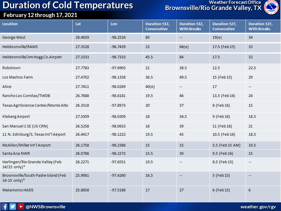
The killing freeze occurred from late evening on Valentine’s Day through around noon on February 16th. Across parts of the ranch country, including northern Zapata through northern Kenedy County, temperatures remained at or below freezing for nearly two full days. However, unlike the most recent prolonged freeze (February 2-5, 2011), ambient temperatures fell into the mid teens to lower 20s during the morning of February 15th, and similar minimum temperatures during the morning of February 16th, with all Lower Valley and ranch locations in hard freeze (27°F or lower) for 6 to 16 hours each day, and 12 to 24 hours in total. The combination of wind and ambient temperatures made it "feel like" 0 to 10°F above during the post-daybreak hours of 7 to 9 AM on the 15th - rivaling observed values during the December 22-24, 1989 period. Another Valley-wide light freeze occurred on the 19th, with a heavy frost (along with temperatures in the upper 20s for most) ending the event early on the 20th.
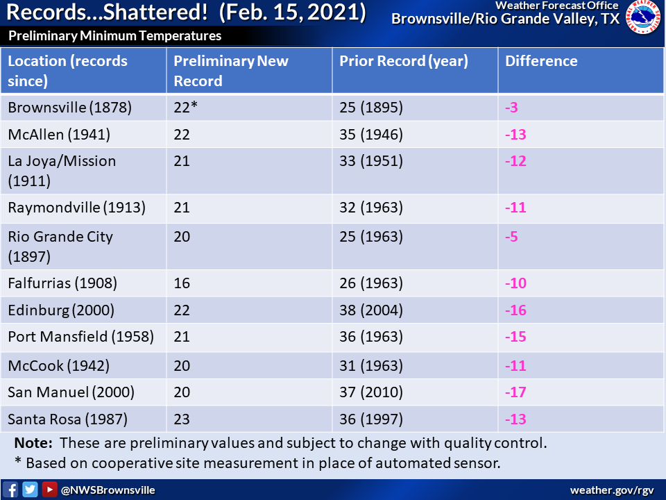
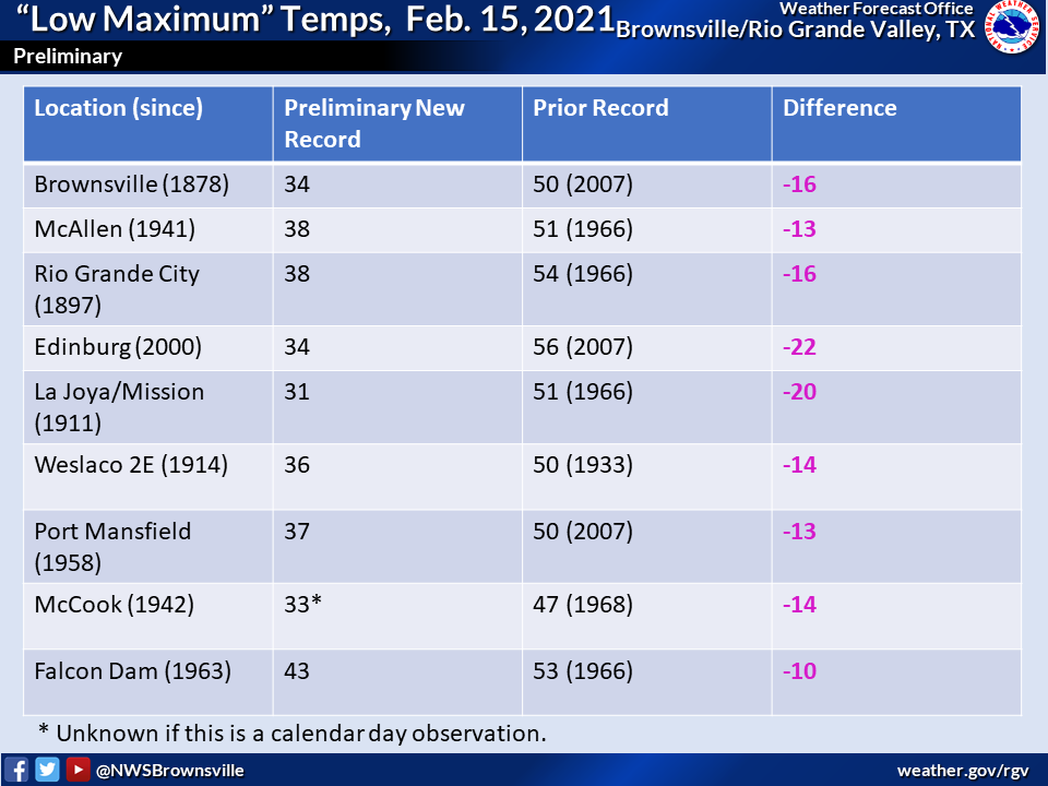
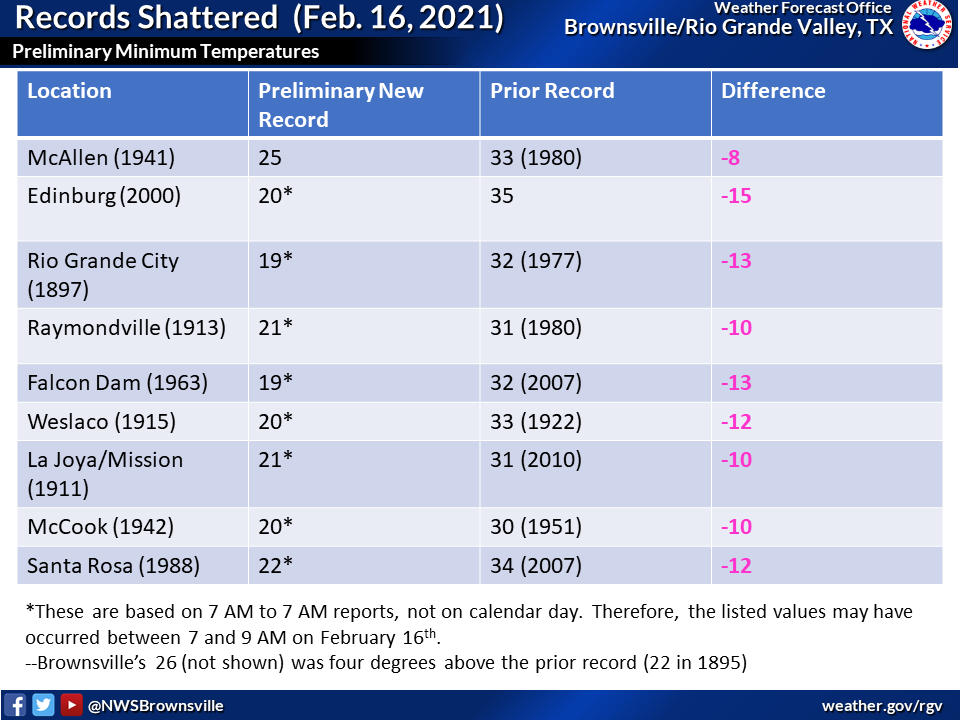
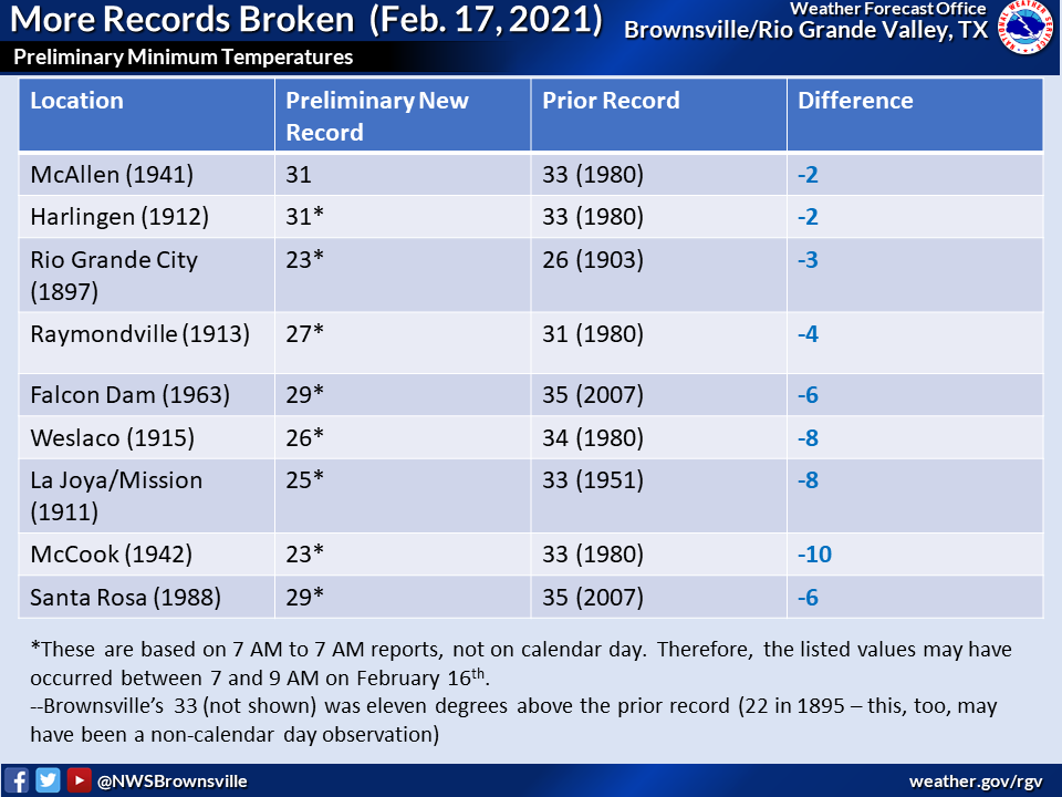
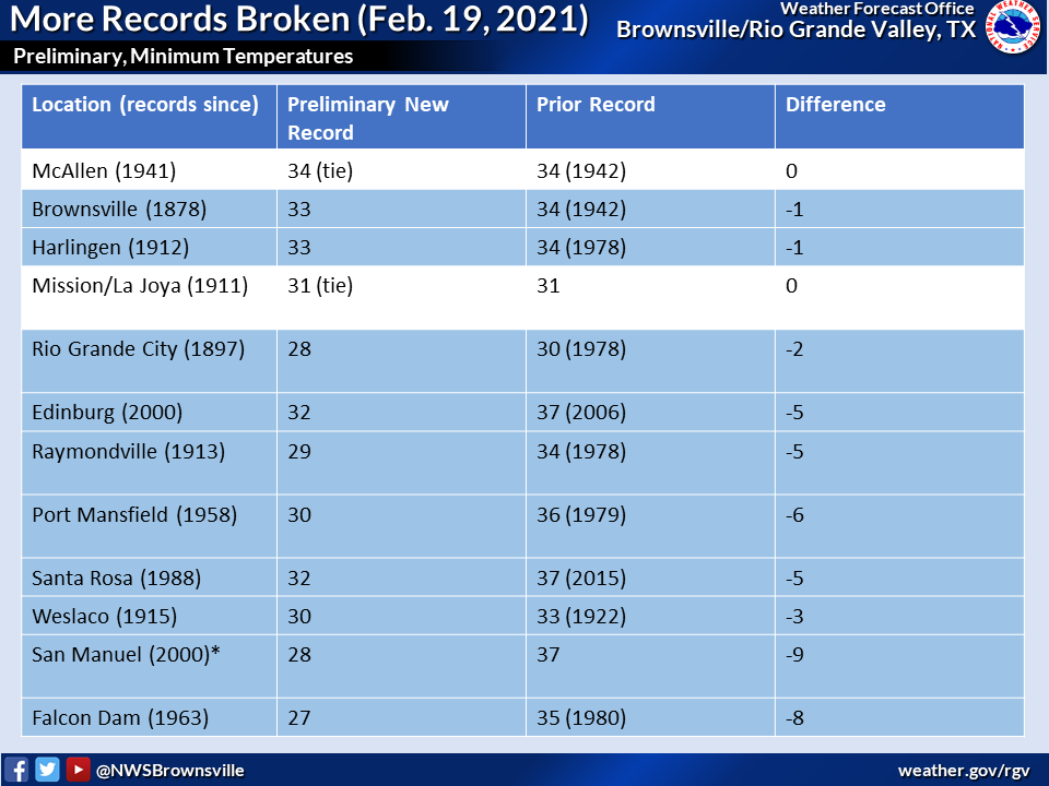
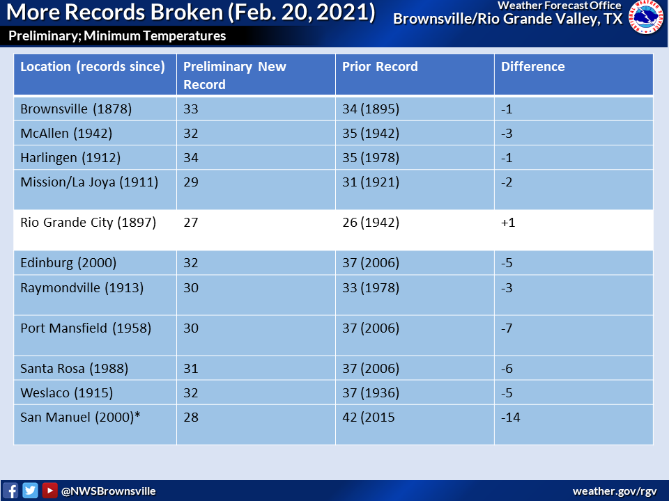
The lateness of the arctic outbreak was unprecedented in the modern record, with only mid February 1895 rivaling 2021 - a time when the Rio Grande Valley’s population was less than one-tenth of what it was today. On the 15th and 16th, new record low temperatures were set everywhere. In locations with periods of record dating back to after 1895, old records were shattered by 8 to 15 degrees, including at some locations with more than 100 years of data! New records were also achieved on the 17th, 19th, and 20th, with smaller departures. Record "low maximum" temperatures were crushed at even greater differences on the 15th, with populated Valley locations breaking the old records by 14 to 20 degrees! Assorted record "low maximum" temperatures were also set prior to the big freeze on the 13th and 14th, when temperatures held in the 30s in most areas.
Summary of Impacts
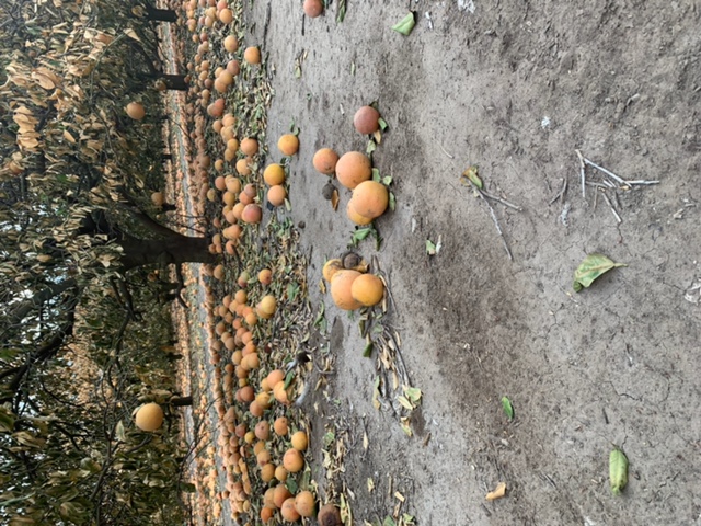
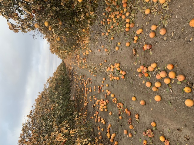
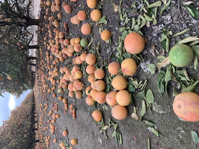
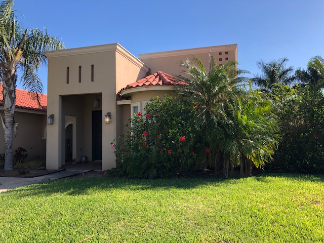
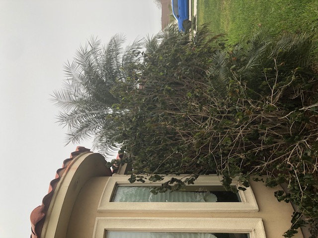
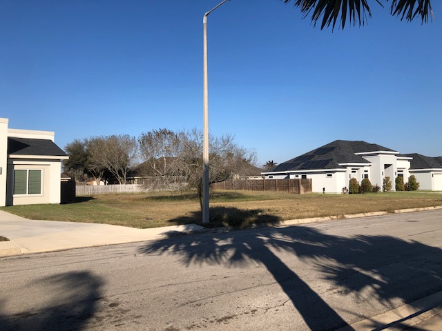
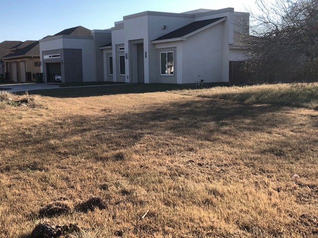
Life in Texas ground to a crawl, or even a halt, as the electric grid became overwhelmed by the unprecedented late season cold and wintry precipitation. For the Lower Rio Grande Valley, this included an unknown number of water main/water pipe bursts, generator failures that affected water pressure, and other infrastructure damage to be determined. Leading into the killing freeze on the 15th was a period of light freezing rain and sleet, which coated trees and grass but also icing up elevated surfaces, causing more than 50 roads to be temporarily closed. When the value of damage to commercial agriculture and aquaculture, ornamental and nursery plants, and built infrastructure such as pipes, generators, and flooded buildings, the total direct damage count will be well over $1 billion, making it two such events (Hanna, July 2020) in less than a year. When economic loss and crop production loss are factored in, the total could exceed $2 billion for the Rio Grande Valley alone. Final values of each won't be available until later in 2021, and this article will be updated to account as new estimates arrive.
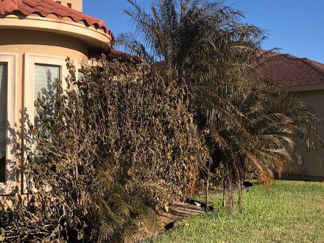
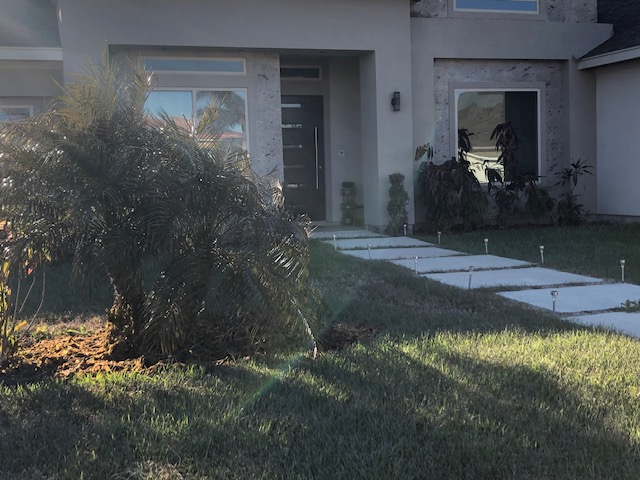
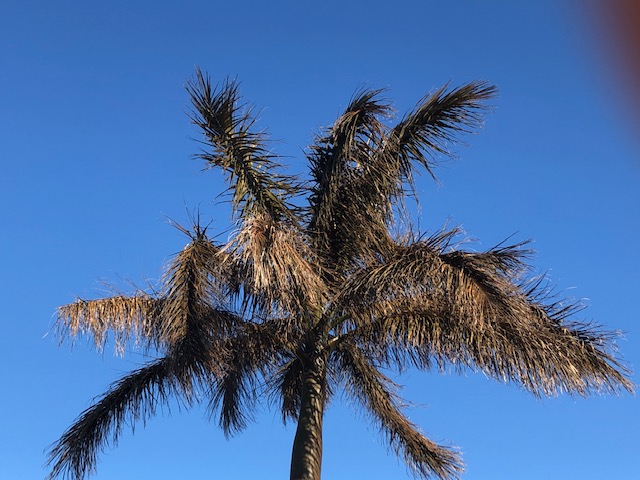
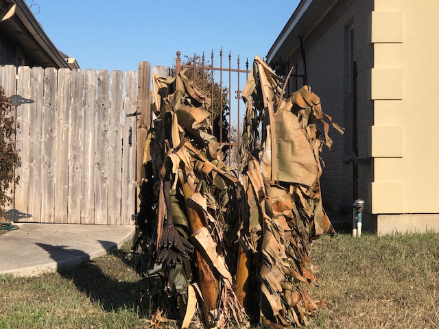
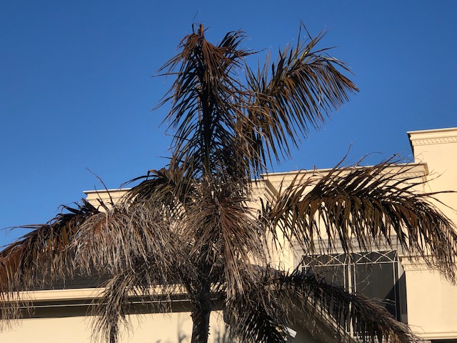
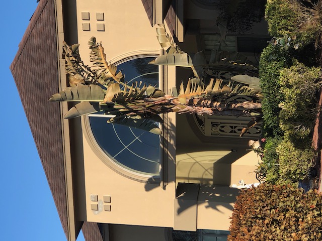
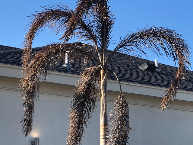
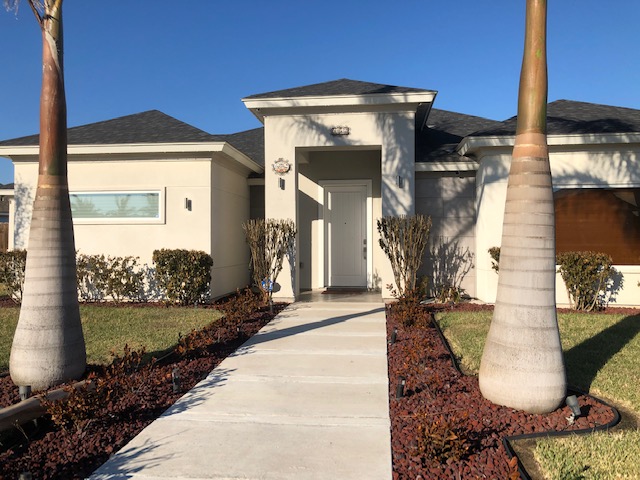
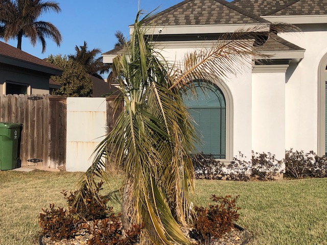
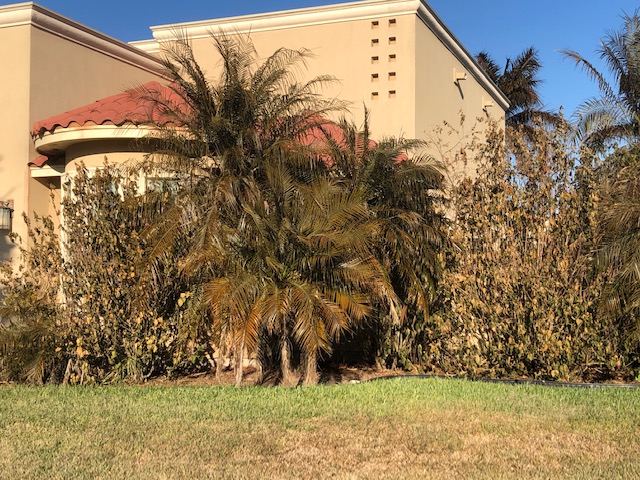
The most costly impacts were to the natural environment. The following items tell the tale (as of mid March, 2021):
| Record Low Temperatures, February 15th 2021 | Record Low Maximum Temperatures, February 15th 2021 |
|---|---|
 |
 |
| Record Low Temperatures, February 16th 2021 | Record Low Temperatures, February 17th 2021 |
 |
 |
| Record Low Temperatures, February 19th 2021 | Record Low Temperatures, February 20th 2021 |
 |
 |
| Duration of Freeze and Hard Freeze, February 12th through February 17th, 2021 | |
 |
|
PRELIMINARY LOCAL STORM REPORT...SUMMARY
NATIONAL WEATHER SERVICE BROWNSVILLE TX

..TIME...   ...EVENT...      ...CITY LOCATION...     ...LAT.LON...
..DATE...   ....MAG....      ..COUNTY LOCATION..ST.. ...SOURCE....
            ..REMARKS..

0830 PM     FREEZING RAIN    1 S WESLACO             26.14N 97.98W
02/14/2021  E0.01 INCH       HIDALGO            TX   AMATEUR RADIO

            REPORT OF ICE ACCUMULATING AT RANCHERO
            VILLAGE MOBILE HOME PARK.

0830 PM     FREEZING RAIN    3 N MCALLEN             26.26N 98.24W
02/14/2021  E0.01 INCH       HIDALGO            TX   AMATEUR RADIO

            REPORT OF ICE ACCUMULATING.

0924 PM     FREEZING RAIN    1 S WESLACO             26.14N 97.98W
02/14/2021  E0.06 INCH       HIDALGO            TX   AMATEUR RADIO

            ICE ACCUMULATION OF 1/16TH OF AN INCH.

0941 PM     FREEZING RAIN    2 SW COMBES             26.23N 97.75W
02/14/2021  E0.01 INCH       CAMERON            TX   PUBLIC

            REPORTS OF SLEET AND ICE ACCUMULATING ON
            TRASH CAN.

1125 PM     FREEZING RAIN    FALFURRIAS              27.23N  98.14W
02/14/2021  E0.10 INCH       BROOKS             TX   DEPT OF HIGHWAYS

            BOTH NORTHBOUND AND SOUTHBOUND SECTIONS OF HIGHWAY 281
            CLOSED IN FALFURRIAS DUE TO ICING ON OVERPASS. TRAFFIC
            BEING DETOURED TO FRONTAGE ROAD. SOURCE
            WWW.DRIVETEXAS.ORG.

1125 PM     FREEZING RAIN    ENCINO                  26.93N  98.13W
02/14/2021  E0.10 INCH       BROOKS             TX   DEPT OF HIGHWAYS

            BOTH NORTHBOUND AND SOUTHBOUND SECTIONS OF HIGHWAY 281
            CLOSED IN ENCIO DUE TO ICING/SNOW ON OVERPASS. TRAFFIC
            BEING DETOURED TO FRONTAGE ROAD. SOURCE
            WWW.DRIVETEXAS.ORG.

1201 AM     FREEZING RAIN    SARITA                  27.22N  97.80W
02/15/2021  E0.10 INCH       KENEDY             TX   LAW ENFORCEMENT

            BOTH NORTHBOUND AND SOUTHBOUND SECTIONS OF THE
            INTERSTATE 69E OVERPASS IN SARITA ARE CLOSED DUE TO
            ICING. TRAFFIC IS BEING DETOURED TO FRONTAGE ROAD.
            REPORT SOURCE WWW.DRIVETEXAS.ORG AND THE SARITA SHERIFFS
            OFFICE.

1229 AM     SLEET            PHARR                   26.18N  98.19W
02/15/2021  E0.2 INCH        HIDALGO            TX   AMATEUR RADIO

            HAM RADIO OPERATOR IN PHARR REPORTED TOTAL FREEZING
            RAIN, SLEET AND SNOW ACCUMULATION OF 1/4 TO 1/2 OF AN
            INCH.

1230 AM     FREEZING RAIN    LOPEZVILLE              26.24N  98.16W
02/15/2021  U0.00 INCH       HIDALGO            TX   DEPT OF HIGHWAYS

            OWASSA FLYOVER ON INTERSTATE I69C NEAR LOPEZVILLE IS
            CLOSED DUE TO ICING. REPORT SOURCE WWW.DRIVETEXAS.ORG

1240 AM     FREEZING RAIN    THOMPSONVILLE           27.21N  98.94W
02/15/2021  U0.00 INCH       JIM HOGG           TX   DEPT OF HIGHWAYS

            ICE AND SNOW ACCUMULATING ON BRIDGES AND OVERPASSES
            (BOTH EAST AND WESTBOUND LANES) ON FM649 IN
            THOMPSONVILLE. TRAVEL IS BEING DISCOURAGED. SOURCE
            WWW.DRIVETEXAS.ORG


1243 AM     FREEZING RAIN    ZAPATA                  26.89N  99.26W
02/15/2021  U0.00 INCH       ZAPATA             TX   DEPT OF HIGHWAYS

            MULTIPLE REPORTS RECEIVED VIA DRIVETEXAS.ORG OF ICING
            OCCURRING ON BRIDGES AND OVERPASSES ON HIGHWAY 83 IN
            ZAPATA COUNTY. TRAVEL IN ZAPATA COUNTY IS BEING
            DISCOURAGED.

1245 AM     FREEZING RAIN    RIO GRANDE CITY         26.38N  98.83W
02/15/2021  U0.00 INCH       STARR              TX   DEPT OF HIGHWAYS

            MULTIPLE REPORTS RECEIVED VIA DRIVETEXAS.ORG OF ICE AND
            SNOW ACCUMLATION OCCURRING ON BRIDGES AND OVERPASSES ON
            HIGHWAY 83, FM1017, FM2686, FM2294, FM2844, FM755,
            FM649, FM3167 AND FM2360 IN STARR COUNTY. TRAVEL IN
            STARR COUNTY IS BEING DISCOURAGED.

0100 AM     FREEZING RAIN    RAYMONDVILLE            26.48N  97.78W
02/15/2021  U0.00 INCH       WILLACY            TX   LAW ENFORCEMENT

            MULTIPLE REPORTS OF ICING ON FM490 AND FM186 BRIDGES
            AND OVERPASSESS IN WILLACY COUNTY.

0200 AM     FREEZING RAIN    BROWNSVILLE             25.93N  97.48W
02/15/2021  M0.02 INCH       CAMERON            TX   NWS EMPLOYEE

            NWS BROWNSVILLE EMPLOYEES MEASURED 0.02 INCHES OF
            FREEZING RAIN ACCRETING ON VEHICLES IN OFFICE PARKING
            LOT. ICE IS ALSO ACCRETING ON GRASS IN THE OFFICE YARD
            AND TREES, BUT NOT ON THE PARKING LOT ASPHALT.

0207 AM     FREEZING RAIN    HARLINGEN               26.20N  97.69W
02/15/2021  U0.00 INCH       CAMERON            TX   LAW ENFORCEMENT

            HARLINGEN PD IS REPORTING THAT THE ARROYO BRIDGE AT
            1500 SOUTH 77 SUNSHINE STRIP IS COMPLETELY ICED OVER.

Meteorology
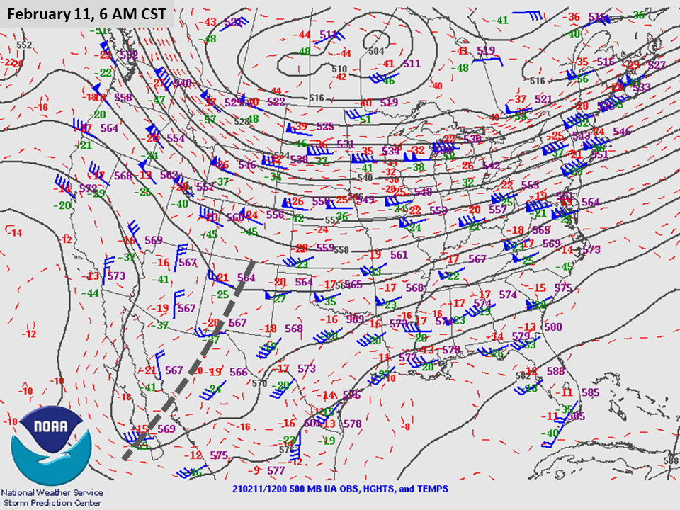
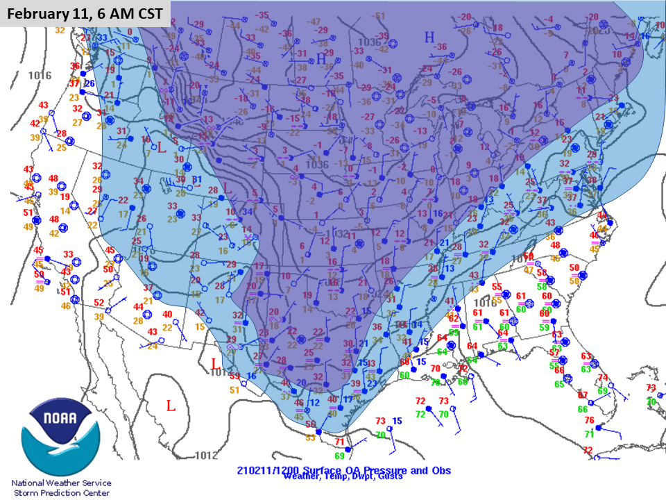
Similar to all of Texas, the event was created by a pool of arctic air that was brought into the northern Great Plains by a "piece" of the circumpolar vortex that slid south toward the Canadian/US border soon after February began. Surface high pressure, reinforced by the presence of the piece of the vortex, oozed into the northern and central Plains, then continued steadily southward, bringing subfreezing temperatures and winter precipitation into north and central Texas around the 10th. Much below average temperatures, but still above freezing (mainly 30s and 40s), crashed into the Lower Valley late on the 11th, and locked in through Valentine’s Day under a steel gray low overcast with occasional drizzle and biting north wind. A strong upper level disturbance, extending from southwest Canada through northwest Mexico, slid eastward late on the 14th and 15th, bringing the seasonally unprecedented surge of frigid air deep into Mexico.
Additional upper level impulses crossed Texas through the 19th, with the final wave exiting the state that day. Each impulse kept the much colder than average air locked in (loop below, on the left). A warm up finally arrived on the 20th, and would continue through the end of the month.
The Event in Context of Winter 2020/21
Preseason outlooks issued as early as October and November, 2020, hinted at the potential for multiple freezes in a winter (December through February) that was forecast to end up warmer and drier than average. Through January, this was indeed the case, as mentioned in the Overview section on the first tab of this report. Though more study will help discover reasons for the unprecented (in time and year) event, a few puzzle pieces stand out. First, the idea of embedded cold outbreaks amidst the warmth was predicated on the continuation of a moderate La Niña. When combined with a persistent negative phase of the Pacific-Decadal Oscillation, which can enhance the impacts of a La Niña the possibility of intrusions of Canadian air makes sense. In 2021, a third atmospheric teleconnection joined these two - a brief but strongly negative phase of the Arctic Oscillation. A similar, strongly negative phase in January 2011 may have previewed the early February freeze and cold snaps through the Great Plains. That year, the phase changed on a dime in February, and warm to hot weather arrived in late February. In 2021, the phase shifted a couple weeks later, not in time to turn the monthly average from negative to positive. March 2021 started generally positive and slightly warmer than average weather prevailed.
For the steering flow pattern animation (left), dashed gray lines represented upper level disturbances that brought wintry precipitation, surges of frigid air, or both. The main wave late on February 14th provided both. Later reinforcing energy waves from the 16th through 18th reinforced cold temperatures across the Valley, but brought more wintry precipitation from south central Texas to north and east Texas through the period, before clearing arrived late on the 19th and warming followed after a final frozen morning on the 20th. For the surface temperatures (right), blue colors represent 15 to 25 degree departures from average, and purple colors more than 25 degree departures from mid February averages - in general, based on temperatures at 6 AM and 6 PM (central time) each day.
| US 500 mb pattern, February 11 through 20, 2021 | US surface weather conditions, February 11 through 20, 2021 |
|---|---|
 |
 |
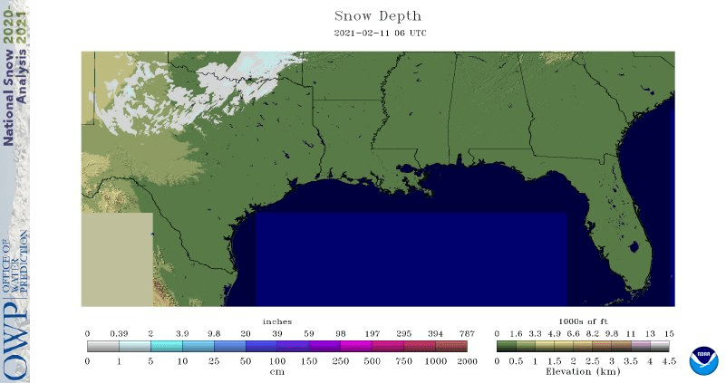
Two key elements on the ground were likely triggers for the intensity and duration of the killing freeze event (late February 14 through noon on February 16th). First, temperatures on Valetine’s Day rose little across the region - in fact, values began falling back toward freezing well before sunset across the Brush Country. This gave the entire region a "head start" on the temperature drop. In addition, snow and sleet accumulation just north of Deep South Texas was underway on the 14th, which allowed for minimal modification of the true arctic airmass that was headed south. This was evident by the small range of temperatures across most of the region, from the mid to upper teens across the ranches to 20-22 everywhere else, including on South Padre Island. That same snow pack held on through the week, ensuring that cold air would remain entrenched across the Valley. Fortunately, some late February sunshine on the 17th and 19th allowed readings to pop into the 50s (except along the coast)...relatively mild but still more than 20 degrees below daytime averages.
| Loop of Southern Plains Snowpack |
|---|
 |

