National Weather Service United States Department of Commerce

171 Sites:

37 Counties, 121 Communities
1 Indian Nation, 8 Government
2 Universities, 1 Commercial
15 Supporters
 

Back to StormReady Communities
StormReady Home
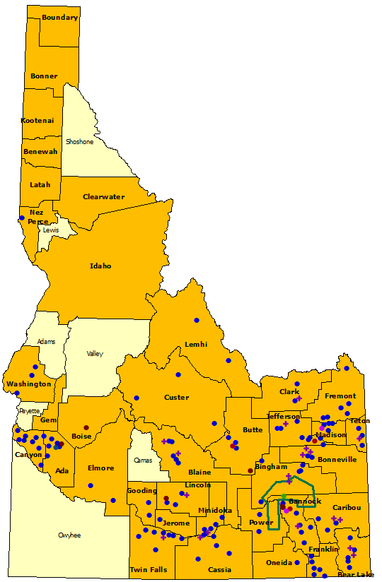
Idaho StormReady sites, text list below map

StormReady County

County

Commercial Site Commercial
community Community StormReady university University
Indian Nation Indian Nation government/military community Government
supporter Supporter    
 
Counties
  • Ada
  • Bannock
  • Bear Lake
  • Benewah
  • Bingham
  • Blaine
  • Boise
  • Bonner
  • Bonneville
  • Boundary
  • Butte
  • Canyon
  • Caribou
  • Cassia
  • Clark
  • Clearwater
  • Custer
  • Elmore
  • Franklin
  • Fremont
  • Gem
  • Gooding
  • Idaho
  • Jefferson
  • Jerome
  • Kootenai
  • Latah
  • Lemhi
  • Lincoln
  • Madison
  • Minidoka
  • Nez Perce
  • Oneida
  • Power
  • Teton
  • Twin Falls
  • Washington
Communities
  • Aberdeen
  • Acequia
  • Albion
  • American Falls
  • Ammon
  • Arco
  • Arimo
  • Ashton
  • Atomic City
  • Bancroft
  • Basalt
  • Bellevue
  • Blackfoot
  • Bloomington
  • Boise
  • Buhl
  • Burley
  • Butte City
  • Caldwell
  • Cambridge
  • Carey
  • Castleford
  • Challis
  • Chubbuck
  • Clifton
  • Dayton
  • Declo
  • Dietrich
  • Downey
  • Driggs
  • Drummond
  • Dubois
  • Eagle
  • Eden
  • Filer
  • Firth
  • Fort Hall
  • Franklin
  • Garden City
  • Garden Valley
  • Georgetown
  • Glenns Ferry
  • Gooding
  • Grace
  • Greenleaf
  • Hailey
  • Hamer
  • Hansen
  • Harrison
  • Hazelton
  • Heyburn
  • Hollister
  • Horseshoe Bend
  • Idaho City
  • Idaho Falls
  • Inkom
  • Island Park
  • Jerome
  • Ketchum
  • Kimberly
  • Kuna
  • Lava Hot Springs
  • Leadore
  • Lewiston
  • Lewisville
  • Lowman
  • Mackay
  • Malad
  • Malta
  • McCammon
  • Melba
  • Menan
  • Meridian
  • Middleton
  • Midvale
  • Minidoka
  • Montpelier
  • Moore
  • Mountain Home
  • Mud Lake
  • Murtaugh
  • Nampa
  • Newdale
  • Notus
  • Oakley
  • Oxford
  • Paris
  • Parker
  • Parma
  • Paul
  • Placerville
  • Pocatello
  • Preston
  • Rexburg
  • Richfield
  • Rigby
  • Ririe
  • Roberts
  • Rockland
  • Rupert
  • Salmon
  • Shelley
  • Shoshone
  • Soda Springs
  • Spencer
  • St. Anthony
  • St. Charles
  • Stanley
  • Star
  • Sugar City
  • Sun Valley
  • Terreton
  • Teton
  • Tetonia
  • Twin Falls
  • Victor
  • Warm River
  • Weiser
  • Wendell
  • Weston
  • Wilder
Indian Nations
Government
Universities
Commercial
  • Shoshone-Bannock Tribes
  • Craters of the Moon National Monument Preserve
  • Eastern Idaho Public Health District
  • Idaho National Laboratory
  • Idaho Transportation Department District 3
  • Idaho Transportation Department District 4
  • Idaho Transportation Department District 5
  • Idaho Transportation Department District 6
  • Southeastern District Health Department
  • Brigham Young University
  • Idaho State University
  • Boise Airport
Supporters
  • Bear Lake County School District #33
  • Bingham Memorial Hospital
  • Blaine County School District #61
  • Cassia County School District #151
  • Idaho Falls Regional Airport
  • KIFI TV Channel 8 USFS Sawtooth
  • KMVT TV Channel 11, Twin Falls
  • National Avalanche Center
  • NOAA Air Resources Laboratory: Field Research Division
  • Portneuf Medical Center
  • Richfield School District #316
  • Snake River School District #52
  • Soda Springs School District #150
  • Teton County School District #401
  • USFS Sawtooth National Avalanche Center, Idaho Falls