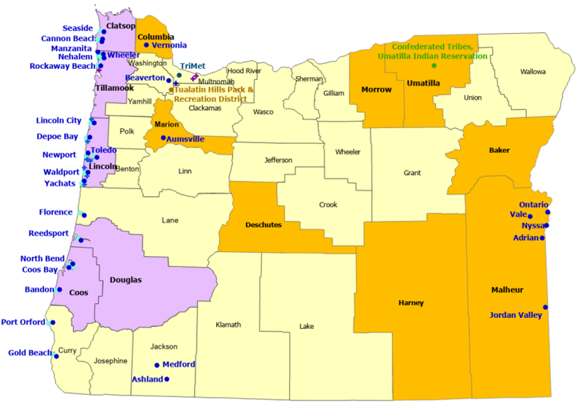
45 Sites
8 Counties, 10 Communities,
1 Indian Reservation, 1 Commercial, 1 Government
4 Supporters
StormReady/TsunamiReady
5 Counties, 19 Communities
8 TsunamiReady Supporters
Back to StormReady Communities
StormReady Home
 |
County |
 |
TsunamiReady |
 |
TsunamiReady |
 |
Indian Nation |
 |
Community |
 |
Supporter |
|
Counties
|
Communities
|
Indian Nations
|
- Baker
- Clatsop*
- Columbia
- Coos*
- Deschutes
- Douglas*
- Harney
- Lincoln*
- Malheur
- Marion
- Morrow
- Tillamook*
- Umatilla
|
- Adrian
- Ashland
- Aumsville
- Bandon*
- Beaverton
- Cannon Beach*
- Coos Bay*
- Depoe Bay*
- Florence*
- Gold Beach*
- Jordan Valley
- Lincoln City*
- Manzanita*
- Medford
|
- Nehalem*
- Newport*
- North Bend*
- Nyssa
- Ontario
- Port Orford*
- Reedsport*
- Rockaway Beach*
- Seaside*
- Toledo*
- Vale
- Vernonia
- Waldport*
- Wheeler*
- Yachats*
|
|
- Confederated Tribes of the Umatilla Indian Reservation
|
|
Commercial
|
- Tri-County Metropolitan Transportation District of Oregon (TriMet)
|
Government
|
- Tualatin Hills Park and Recreation District
|
|
| Supporters |
- Bridgestone Tire Distribution Center
- Central Oregon Coast Fire District**
- Columbia Gorge Premium Outlets
- Depoe Bay Fire District**
|
- Garibaldi School**
- Hatfield Marine Science Center**
- Lincoln County School District**
- North Lincoln Fire and Rescue District**
|
- Seal Rock Fire District**
- Woodburn Premium Outlets
- Yachats Rural Fire District**
|
|
|

