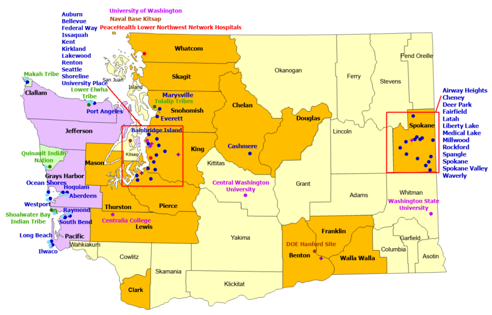
67 Sites
15 Counties, 26 Communities, 2 Government
4 Universities, 2 Commercial
6 Supporters
StormReady/TsunamiReady
4 Counties, 10 Communities, 5 Indian Nations/Tribes
Back to StormReady Communities
StormReady Home
 |
County |
 |
Government |
 |
Indian Nation |
 |
University |
 |
Community |
 |
Commercial |
 |
TsunamiReady |
 |
Supporter |
 |
Indian Nation |
|
|
|
Counties
|
Communities
|
Indian Nations
|
- Benton
- Chelan
- Clallam*
- Clark
- Douglas
- Franklin
- Grays Harbor*
- Jefferson*
- King
- Lewis
|
- Mason
- Pacific*
- Pierce
- Skagit
- Snohomish
- Spokane
- Thurston
- Walla Walla
- Whatcom
|
|
- Aberdeen*
- Airway Heights
- Auburn
- Bainbridge Island*
- Bellevue
- Cashmere
- Cheney
- Deer Park
- Everett
- Fairfield
- Federal Way
- Hoquiam*
|
- Ilwaco*
- Issaquah
- Kent
- Kirkland
- Lakewood
- Latah
- Liberty Lake
- Long Beach*
- Marysville
- Medical Lake
- Millwood
- Ocean Shores*
- Port Angeles*
|
- Raymond*
- Renton
- Rockford
- Seattle
- Shoreline
- South Bend*
- Spangle
- Spokane
- Spokane Valley
- University Place
- Waverly
- Westport*
|
|
- Lower Elwha Tribe*
- Makah Tribe*
- Quinault Indian Nation*
- Shoalwater Bay Indian Tribe*
- Tulalip Tribes
|
|
Government
|
- DOE Hanford Site
- Naval Base Kitsap
|
|
Universities
|
Supporters |
Commercial
|
- Central Washington University
- Centralia College
- University of Washington
- Washington State University
|
- Agilent Technologies, Spokane
- Columbia Center
- North Bend Premium Outlets
- Northgate Mall
- Seattle Premium Outlets
- Tacoma Mall
|
- PeaceHealth Lower Northwest Network Hospitals
|
| *TsunamiReady and StormReady |
|

