
Easter Sunday Mississippi Tornadoes
April 17th, 2022
Summary of all Local Storm Reports (LSRs) on April 17th, as well as all the LSRs across the region for this event.
The storm survey team preliminarily found that 2 EF-2 tornadoes and 1 EF-1 tornado occurred during this event. Two of the tornadoes occurred in Perry County, MS - one tornado in Beaumont was rated an EF-2 and the other tornado near Richton was rated an EF-1. A third tornado occurred near Avera, MS (Greene County). One injury was reported with the Avera tornado.
The data provided on this page are considered preliminary as we continue to analyze all available data. We will add more information to this page and social media as it becomes available. We thank you in advance for your patience.
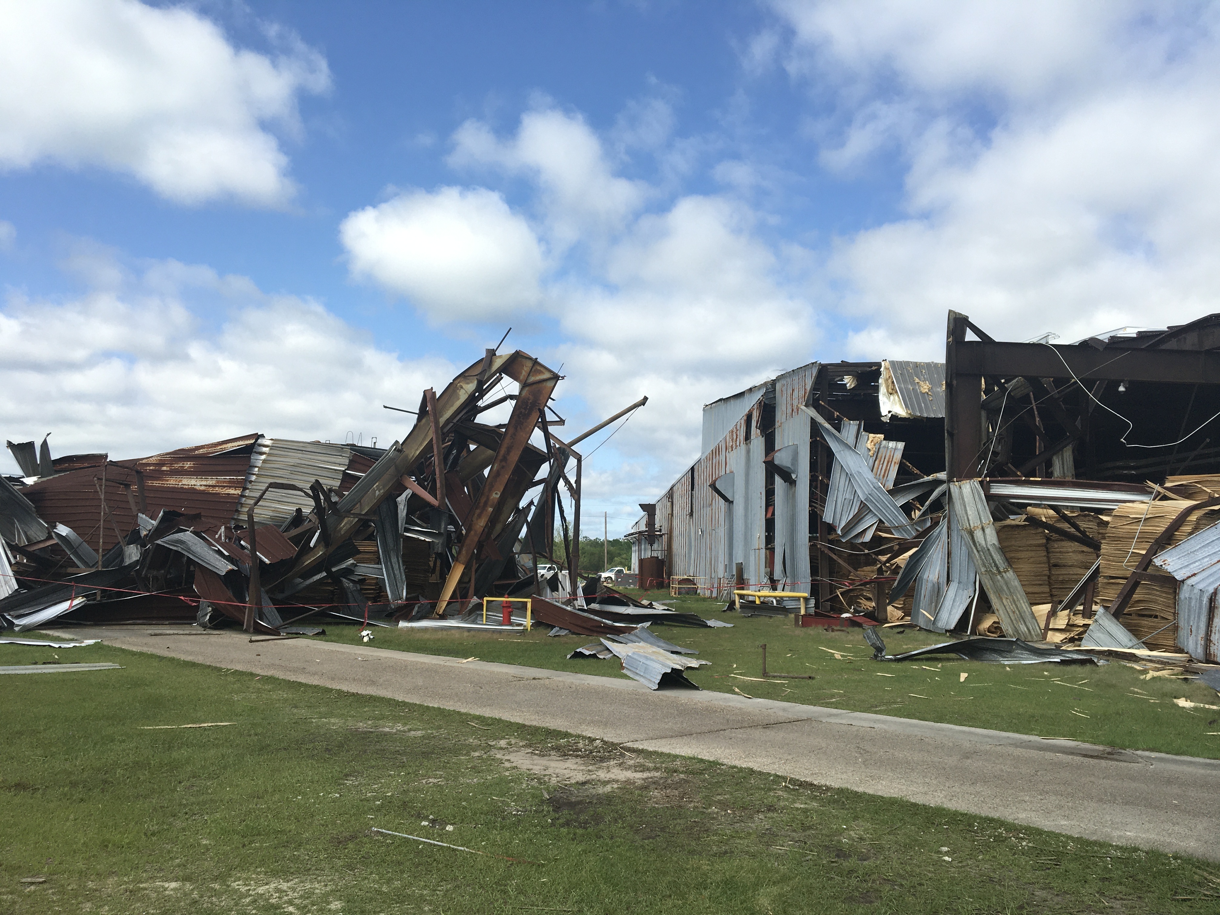
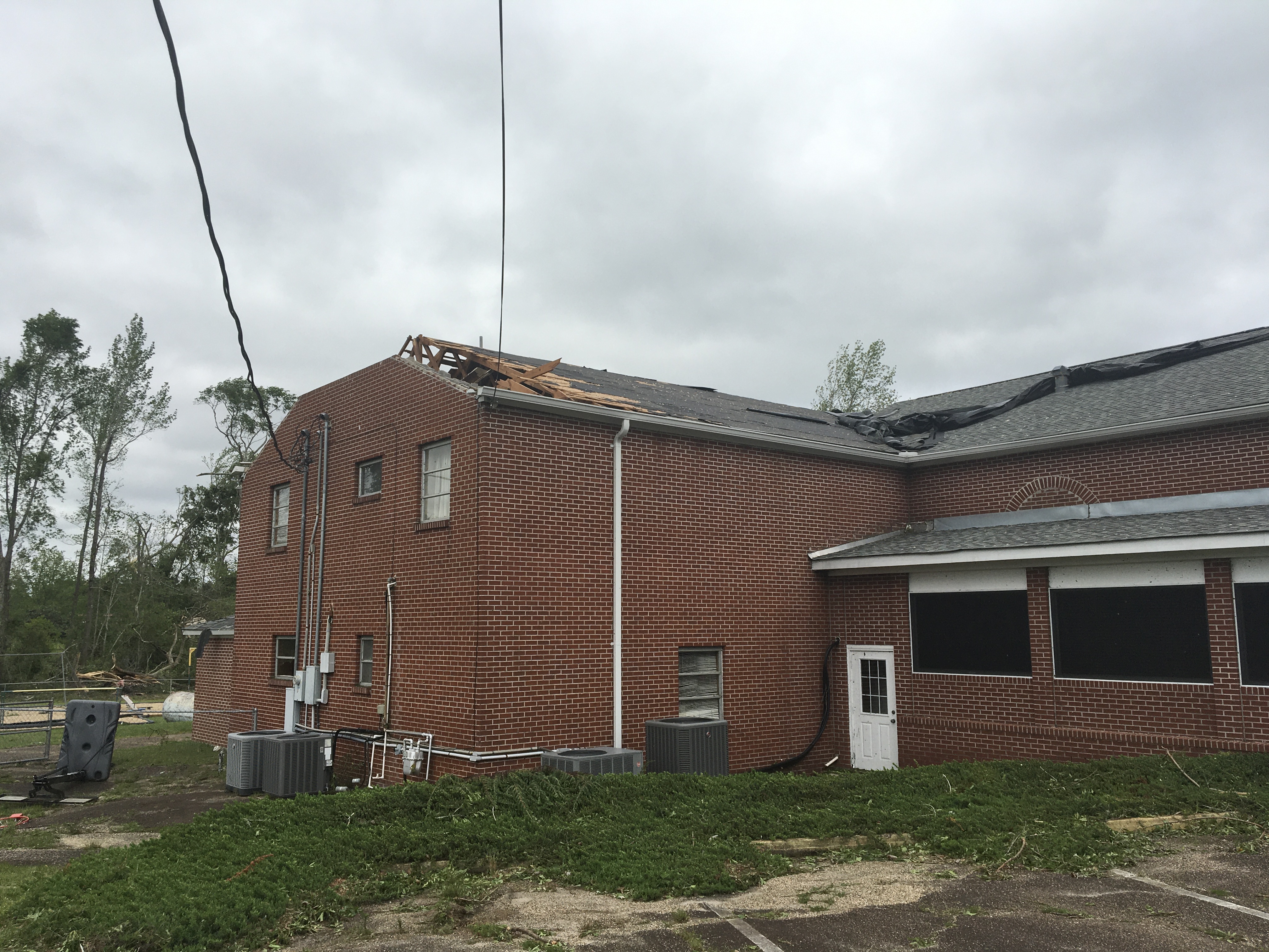
Beaumont Tornado (Perry County, MS)

Public Information Statement
National Weather Service Mobile AL
755 PM CDT Mon Apr 18 2022

...NWS Damage Survey for 04/17/2022 Tornado Event...

..Beaumont Tornado...

Rating:                 EF2
Estimated Peak Wind:    120 mph
Path Length /statute/:  1.6683 miles
Path Width /maximum/:   275.0 yards
Fatalities:             0
Injuries:               0

Start Date:             04/17/2022
Start Time:             08:52 PM CDT
Start Location:         1 WNW Beaumont / Perry County / MS
Start Lat/Lon:          31.1805 / -88.9366

End Date:               04/17/2022
End Time:               08:54 PM CDT
End Location:           1 ENE Beaumont / Perry County / MS
End Lat/Lon:            31.1716 / -88.9112

Survey Summary:
A bowing segment of storms produced a tornado beginning along
Highway 198 near Isabelle Loop just northwest of downtown
Beaumont. The tornado traveled along the tracks of the Canadian
National Railroad, uprooting a tree which fell onto a manufactured
home in its wake. By this time, the tornado had strengthened to
an EF-2 and entered a lumber mill and caused extensive damage to
two large metal buildings. One of the buildings collapsed on
itself, likely due to it being only partially enclosed. Nearby
power poles were damaged, with one snapped clean at its base.
Damage was rated near expected bounds given the age and
construction of the metal buildings which lined up to the snapped
utility pole. The tornado quickly weakened somewhat (to an EF-1),
and continued southeast along the railroad tracks due to the
motion of the parent bowing segment. As it moved along, it caused
a decent amount of tree destruction to numerous hardwood and
softwood trees. As the tornado crossed Bolton Avenue and MS-15, it
restrengthened briefly into an EF-2 and snapped many hardwoods
and softwoods as well as uprooting several trees. It also damaged
the roof of a nearby small home and the roof of a church. A shed
or carport on the church property was also destroyed. More trees
were damaged as the tornado continued to move southeast and also
destroyed a large shed/unattached garage. The tornado then moved
east, parallel to 1st Street, where it likely lifted and
dissipated; however, the survey team was not able to access this
area as the street was closed due to down power poles and
continued tree damage.

&&

EF Scale: The Enhanced Fujita Scale classifies tornadoes into the
following categories:

EF0...Weak......65 to 85 mph
EF1...Weak......86 to 110 mph
EF2...Strong....111 to 135 mph
EF3...Strong....136 to 165 mph
EF4...Violent...166 to 200 mph
EF5...Violent...>200 mph

NOTE:
The information in this statement is preliminary and subject to
change pending final review of the event and publication in NWS
Storm Data.
The photos below were taken during the tornado survey in the Beaumont community in Perry County and show the extent of the damage along the path of the EF-2 tornado.


Richton Tornado (Perry County, MS)
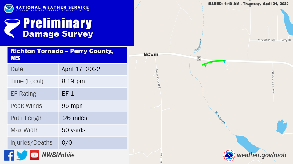
Public Information Statement
National Weather Service Mobile AL
955 AM CDT Wed Apr 20 2022

...NWS Damage Survey for 04/17/2022 Richton MS Tornado Event...

..Richton MS...

Rating:                 EF1
Estimated Peak Wind:    95 mph
Path Length /statute/:  0.26 miles
Path Width /maximum/:   50.0 yards
Fatalities:             0
Injuries:               0

Start Date:             04/17/2022
Start Time:             08:19 PM CDT
Start Location:         2 W Richton / Perry County / MS
Start Lat/Lon:          31.3579 / -88.9778

End Date:               04/17/2022
End Time:               08:20 PM CDT
End Location:           2 WNW Richton / Perry County / MS
End Lat/Lon:            31.3584 / -88.9734

Survey Summary:
A brief tornado began along Highway 42 west of Richton destroying
a barn and heavily damaging another barn as it quickly reached
peak intensity. An open door structure and older construction
supported a lower bound estimate to the damage. The tornado
continued to the east northeast where several trees and large
branches were snapped. A clear convergence path was noted in the
damage just south of Highway 42. A carport was picked up and
deposited a couple hundred yards down path in power lines. The
tornado then weakened as it likely crossed Highway 42 with a few
large branches snapped and a couple uproots noticed. Some shingle
damage was also noted to a nearby home before the tornado lifted.


&&

EF Scale: The Enhanced Fujita Scale classifies tornadoes into the
following categories:

EF0...Weak......65 to 85 mph
EF1...Weak......86 to 110 mph
EF2...Strong....111 to 135 mph
EF3...Strong....136 to 165 mph
EF4...Violent...166 to 200 mph
EF5...Violent...>200 mph

NOTE:
The information in this statement is preliminary and subject to
change pending final review of the event and publication in NWS
Storm Data.
Avera Tornado (Greene County, MS)
 Public Information Statement
National Weather Service Mobile AL
755 PM CDT Mon Apr 18 2022
...NWS Damage Survey for 04/17/2022 Tornado Event...
Public Information Statement
National Weather Service Mobile AL
755 PM CDT Mon Apr 18 2022

...NWS Damage Survey for 04/17/2022 Tornado Event...
..Avera Tornado...

Rating:                 EF2
Estimated Peak Wind:    130 mph
Path Length /statute/:  1.7706 miles
Path Width /maximum/:   400.0 yards
Fatalities:             0
Injuries:               1

Start Date:             04/17/2022
Start Time:             09:02 PM CDT
Start Location:         1 S Avera / Greene County / MS
Start Lat/Lon:          31.2869 / -88.7427

End Date:               04/17/2022
End Time:               09:06 PM CDT
End Location:           2 SE Avera / Greene County / MS
End Lat/Lon:            31.273 / -88.7176

Survey Summary:
A QLCS produced a tornado off of Highway 63 and Lovewell Road
south of the town of Avera, initially snapping and uprooting
trees. One of the trees fell onto a vehicle near a manufactured
home. As the tornado moved southeast it strengthened into an EF-2,
snapping and decimating many large hardwood oak trees. The degree
of damage to these trees were enough to support a higher end
intensity estimate. A large tree limb from one of these oak trees
was turned into a projectile and injured a woman when it pierced
the side of the aforementioned manufactured home. The tornado
proceeded southeast, continuing to destroy hardwood trees in its
wake. It passed through an open field before coming upon more
trees and a small manufactured home. It snapped and uprooted many
of these trees (both soft and hardwood), with two falling onto the
manufactured home. The tornado then likely weakened to an EF-1
and continued southeastward, almost parallel to Highway 63. It
lifted and dissipated just before it reached Avera Road, but not
before tossing a large grain holder and tearing off metal portions
of a nearby barn roof. Debris from this roofing was seen strewn
out over the field.

&&

EF Scale: The Enhanced Fujita Scale classifies tornadoes into the
following categories:

EF0...Weak......65 to 85 mph
EF1...Weak......86 to 110 mph
EF2...Strong....111 to 135 mph
EF3...Strong....136 to 165 mph
EF4...Violent...166 to 200 mph
EF5...Violent...>200 mph

NOTE:
The information in this statement is preliminary and subject to
change pending final review of the events and publication in NWS
Storm Data.
The photos below were taken during the tornado survey in the Avera community in Greene County and show the extent of the damage along the path of the EF-2 tornado.


Additional Information
NWS Local Write-Ups and Webpages:
NWS Jackson, MS
Acknowledgements: Page created by Christina Leach (Forecaster) and Morgan Barry (Forecaster). Updated by Michael Mugrage (Forecaster).
LAST UPDATE: March 2024


 Follow us on YouTube