
An area of low pressure began to organize from a tropical disturbance on June 16, 2017 in the western Caribbean Sea near the coast of Nicaragua and Honduras. The area of low pressure continued to move northwest towards the Yucatan Peninsula throughout the weekend and into Monday, June 19. On Monday afternoon, the low pressure emerged into the southern Gulf of Mexico and the National Hurricane Center (NHC) designated the system as Potential Tropical Cyclone #3 as it became better organized. The disturbance moved slowly northwestward and at 1pm CDT on June 20th, the system gained tropical storm strength and became Tropical storm Cindy with max sustained winds of 45mph.
 Cindy remained nearly stationary throughout the rest of the afternoon on the 20th. Later that night, Cindy strengthened to have maximum sustained winds of 60mph and the storm began a slow northwest track. On the morning of June 21, Cindy weakened slightly to have maximum sustained winds of 50mph continuing on a northwest track. Later that evening, a more north-northwestward track was observed as Cindy began moving closer the coast (near the border of Texas and Louisiana) with heavy rains continuing to be an issue along the northern Gulf Coast.
The center of Tropical Storm Cindy made landfall between Cameron, Louisiana and Port Arthur, Texas in the early morning hours of June 22 with maximum sustained winds between 40-50mph. Tropical storm force winds extended up to 70 miles from the center of circulation! Cindy continued to move along the Texas and Louisiana border producing heavy rains across the northern Gulf Coast. Cindy was downgraded to a tropical depression on June 22 and the final advisory was issued at 10am as the center was moving across northern Louisiana. The remnants continued to move north to northeast into Arkansas and Tennessee.
Unfortunately, there were two deaths directly related to Tropical Storm Cindy. On the 21st, a child was killed in the Gulf of Mexico near Fort Morgan (Baldwin County, AL) when a large wave hit a large log and caused it to hit the child in the head. On the 23rd, a man drowned in the Gulf of Mexico near Fort Morgan while attempting to rescue two children in distress.
Summary of all Local Storm Reports (LSRs) across the area during Tropical Storm Cindy.
Tropical Storm Cindy made landfall well to the west of our area, but significant impacts were felt across the region. The majority of this document will focus on the impacts from flooding (including coastal flooding) across southeast Mississippi, southwest Alabama and northwest Florida. Below are some of the regional impacts...
Jump to - Rainfall, Wind, Storm Surge, Tornado, Post-Tropical Cyclone Report, or Additional Information sections.
The outer rainbands of Tropical Storm Cindy began dropping heavy rain on the north-central Gulf Coast during the late evening hours on June 19 with the risk of flash flooding ramping up across the area. These outer rainbands continued to produce training lines of heavy rain across the area (far away from the center of circulation) through the day and into the evening hours on June 20th. Flash Flood Warnings were issued shortly after 10pm on June 20 for Mobile and Baldwin Counties in Alabama and Perry and Greene Counties in Mississippi. These Flash Flood Warnings persisted until Cindy moved out of the area.

Several locations across the area observed high storm total rainfall amounts for the duration of the event. The image above shows the storm total rainfall across the region with pockets of 10"+ across all three states in our area. Storm total rainfall amounts of 8-10" occurred across Santa Rosa and Escambia Counties in the northwest Florida panhandle. 9.58" storm total rainfall occurred at NAS Whiting Field, 9.46" near Gonzalez, and 8.58" at the Pensacola International Airport. In Mobile County, rainfall amounts of 8-10” occurred near Saraland with a storm total rainfall report of 8.97” at a CoCoRAHS site near Saraland. Clarke County EMA in southwest Alabama had reports of 11.5" in Coffeeville and 11.37" in Thomasville. Across southeast Mississippi, radar estimated storm total rainfall amounts of 10-15"+ with measurements of 8.5" in Wiggins, 7.57" near Perkinston, and 6.57" in McLain.
 Street and river flooding occurred across much of the area during Tropical Storm Cindy and led to numerous road closures. Across southern Alabama, the Styx River at Elsanor rose to Moderate Flood Stage, while both Murder and Burnt Corn Creeks observed minor river flooding. Portions of Brewton in Escambia County, AL were underwater near Murder and Burnt Corn Creeks. Numerous roads were closed due to flooding with reports of several washed out roads across Clarke County. One road was washed out due to a pond dam that breached with reports of two roads collapsing during the height of the event. Numerous road closures due to flash flooding also occurred across Butler, Covington, and Crenshaw Counties. Water was reported over roads in both Washington and Choctaw Counties as well.
Moderate river flooding occurred across southeast Mississippi on the Pascagoula River at Merrill, Leaf River at McLain, and Chickasawhay River at Leaksville. A historic, abandoned bridge that spanned the Chicasawhay River north of Leakesville collapsed due to the rapidly rising waters. This Facebook video from Mississippi Department of Transportation (MDOT) shows how extensive the fooding was across parts of George County, MS. To the right is an aerial view of the extensive flooding across George County via the George County EMA and Central Volunteer Fire Department Fire Chief. Below are more views of the flooding across George County via the George County EMA and Basin Volunteer Fire Department Fire Chief. Further north in Wayne County, numerous roads were closed due to flash flooding during the height of the storm.


 Across northwest Florida, moderate river flooding occurred along the Big Coldwater Creek at Milton. Minor river flooding occurred along the Escambia River at Century, Perdido River at Barrineau Park, Shoal River at Crestview, and Blackwater River at Baker. According to the Florida Forest Service, significant flooding occurred throughout the western part of the Blackwater River State Forest. This flooding led to the closure of numerous major roads across that area due to the concern for flood damage and high water levels at several local bridges. The picture to the right shows one example of the flooding at Wolfe Creek along Springhill Rd via the Santa Rosa County EMA Facebook page. Widespread flooding (similar to the picture on the right) led to numerous roads becoming impassable with road closures across the northwest Florida panhandle during Tropical Storm Cindy.
Impacts from the wind were fairly minimal across the region, but there were some scattered power outages and trees down. Several reports of trees and powerlines down across the coastal counties and reports of trees blocking roads in Clarke County, AL during Cindy. The strongest winds occurred along the immediate coastline where the onshore flow produced the highest wind gusts. The highest wind gust observed during Cindy was 52mph at the Middle Bay Lighthouse (Mobile Bay) around 214pm on the 21st of June. Elsewhere, along the Alabama and western Florida panhandle coastline, peak wind gusts of 40-50mph were common. The highest observed wind gusts started the morning of the 21st at coastal and marine sites (Buoy 42012, Dauphin Island, Okaloosa Pier, and Destin) and lasted through the early afternoon hours on the 22nd at sites further inland (Crestview, Evergreen, and Andalusia). Some of the higher wind gusts reported across the area are as follows:
| Location | Wind Gust (mph) |
| LAND SITES | |
| KNPA - Pensacola NAS | 47 |
| KMOB - Mobile Regional Airport | 44 |
| XBUC - Buccaneer Yacht Club - WF | 44 |
| XGLF - Gulf Shores - WF | 44 |
| KPNS - Pensacola Regional Airport | 41 |
| KBFM - Brookley Field | 40 |
| KJKA - Gulf Shores | 38 |
| KDTS - Destin | 37 |
| KGZH - Evergreen | 36 |
| KCQF - Fairhope | 35 |
| KCEW - Crestview | 31 |
| K79J - Andalusia | 27 |
| MARINE SITES | |
| MBLA1 - Middle Bay Lighthouse | 52 |
| XFPL - Pensacola Bay - WF | 48 |
| XFWB - Ft Walton Beach - WF | 46 |
| KATA1 - Katrina Cut | 45 |
| CRTA1 | 45 |
| XOFP - Okaloosa Pier - WF | 45 |
| Buoy 42012 - 12S Orange Beach | 45 |
| XMLP - Perdido Bay - WF | 44 |
| DPIA1 - Dauphin Island | 43 |
WF stands for a WeatherFlow site
STORM SURGE & COASTAL FLOODING
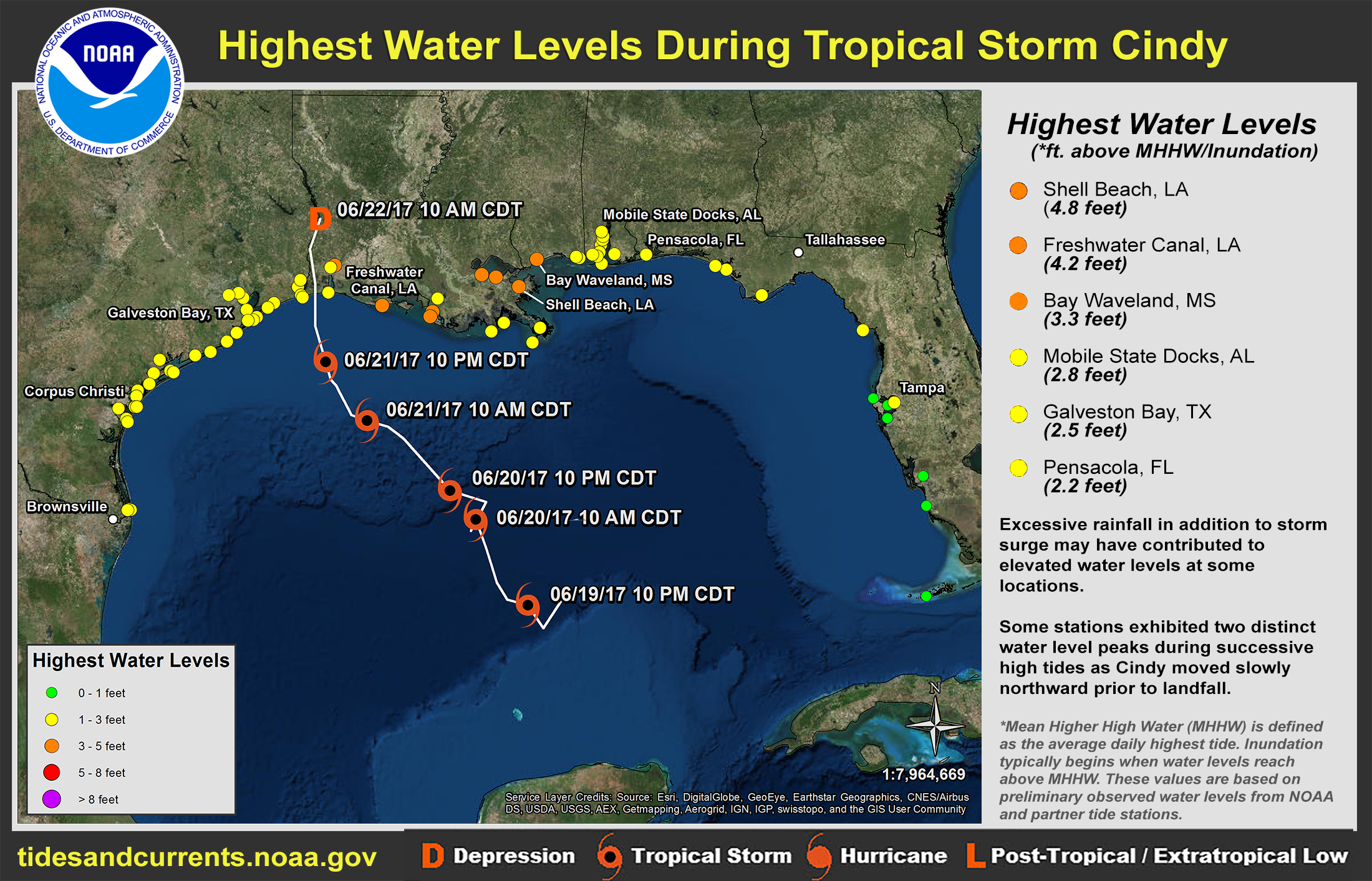
Coastal flooding and storm surge caused roads across southern Alabama and northwest Florida to close during Tropical Storm Cindy. Peak storm surge inundation was generally 2-3 feet based on official tide gauges across coastal Alabama and Escambia County in northwest Florida. The highest values across our area were observed in Mobile County where Chickasaw Creek measured a storm tide of 3.07 feet (MHHW). Official NOAA/NOS/CO-OPS tide gauges were used to measure the maximum storm surge and storm tide across the area during Tropical Storm Cindy. Time series plots from several of these NOAA/NOS/CO-OPS tide gauges across coastal Alabama and northwest Florida can be viewed below.


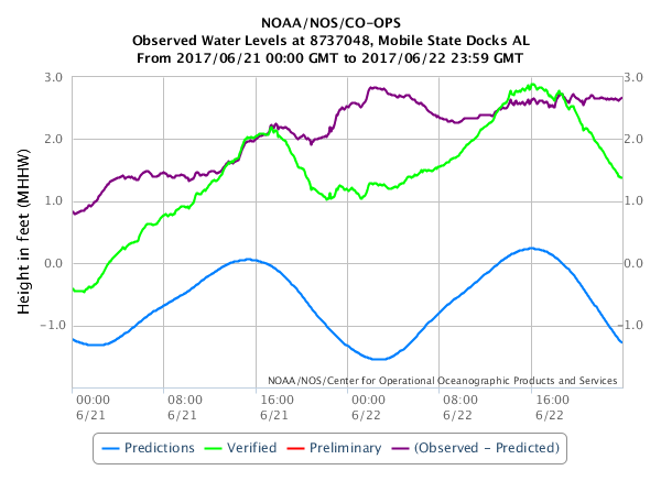


In Mobile County, Dauphin Island Parkway north of the Dog River Bridge experienced coastal flooding near high tide on the 22nd. 1-2 feet of inundation occurred on Bienville Blvd on the west end of Dauphin Island near high tide on both the 21st and 22nd. Shell Belt Rd in the Bayou La Batre and Coden communities was covered in water at times during the event. Both the eastbound and westbound lanes of the Causeway over Mobile Bay (Highway 90) near the I-10 interchange were closed due to coastal flooding during the height of the event. Across the bay in Baldwin County, a sidewalk near the Fairhope pier was damaged due to a combination of coastal flooding and battering waves. There was also standing water from coastal flooding across Bayfront Park Pavilion in Daphne.
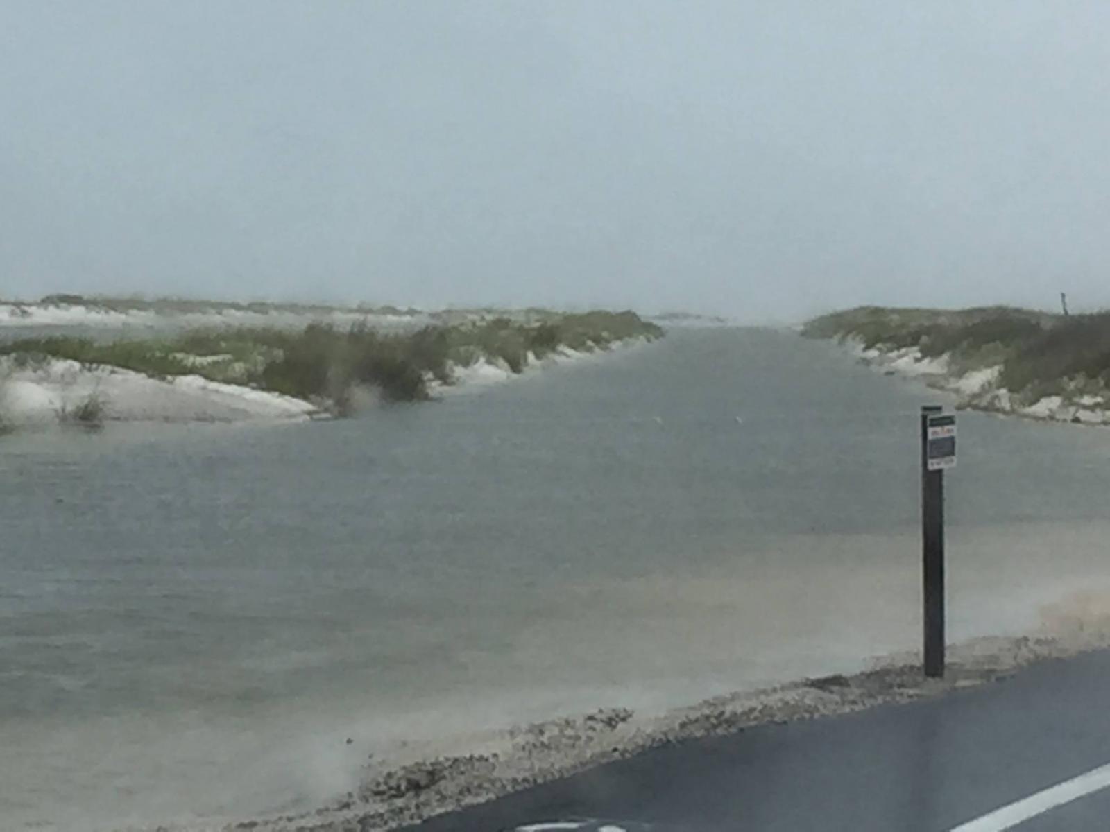
Across northwest Florida, Highway 399 closed due to coastal flooding. The Fort Pickens, Santa Rosa, Okaloosa, and Davis Bayou areas within the Gulf Islands National Seashore all closed during Tropical Storm Cindy. Below are pictures from the Gulf Islands National Seashore Facebook page showing the extent of the flooding in the Fort Pickens and Opal Beach areas.

Cindy spawned at least five tornadoes and numerous waterspouts across the area. Four of the five tornadoes were brief and rated EF0, while one tornado was rated EF1. The EF1 tornado in Covington County, AL produced significant tree damage in spots across its 5 mile track. Minor siding and roof damage was observed along the path of this tornado near Onycha, AL in Covington County.
The remaining four EF0 tornadoes occurred in Okaloosa County, FL; Escambia County, AL; Baldwin County, AL; and Clarke County, AL. The tornadoes near Parker Springs, AL (in the Conecuh National Forest) in Escambia County and near Whatley, AL in Clarke County mainly produced tree damage. The tornado near Fort Walton Beach in Okaloosa County produced minor damage to a few structures, as well as power line and tree damage. The last EF0 tornado near Summerdale, AL in Baldwin County was observed on video via a storm spotter. This tornado moved across an open field just west of the Beach Express Rd and there was no reported damage.
POST TROPICAL CYCLONE REPORT...TROPICAL STORM CINDY
NATIONAL WEATHER SERVICE MOBILE AL
349 PM CDT MON JUL 10 2017

NOTE: THE DATA SHOWN HERE ARE PRELIMINARY....AND SUBJECT TO UPDATES
AND CORRECTIONS AS APPROPRIATE.

THIS REPORT INCLUDES EVENTS OCCURRING WHEN WATCHES AND/OR WARNINGS
WERE IN EFFECT...OR WHEN SIGNIFICANT FLOODING ASSOCIATED WITH CINDY
OR ITS REMNANTS WAS AFFECTING THE AREA.

COUNTIES INCLUDED...BALDWIN...BUTLER...CHOCTAW...CLARKE...CONECUH...
COVINGTON...CRENSHAW...ESCAMBIA AL...ESCAMBIA FL...GEORGE...
GREENE...MOBILE...MONROE...OKALOOSA...PERRY...SANTA ROSA...STONE...
WASHINGTON...WAYNE...WILCOX

A. LOWEST SEA LEVEL PRESSURE/MAXIMUM SUSTAINED WINDS AND PEAK GUSTS
---------------------------------------------------------------------
METAR OBSERVATIONS...
NOTE: ANEMOMETER HEIGHT IS 10 METERS AND WIND AVERAGING IS 2 MINUTES
---------------------------------------------------------------------
LOCATION  ID    MIN    DATE/     MAX      DATE/     PEAK    DATE/
LAT  LON        PRES   TIME      SUST     TIME      GUST    TIME
DEG DECIMAL     (MB)   (UTC)     (KT)     (UTC)     (KT)    (UTC)
---------------------------------------------------------------------
KMOB-MOBILE REGIONAL
30.67 -88.24   1009.7 21/2156   200/027  22/1600   200/038 22/1559

KBFM-MOBILE BROOKLEY
30.64 -88.07   1010.1 21/2153   140/028  22/0006   140/035 22/0005

KJKA-GULF SHORES
30.29 -87.67                  I 120/021  21/2235   140/033 21/2315

KCQF-FAIRHOPE
30.46 -87.88                  I 160/024  22/1735   180/030 22/1755

KPNS-PENSACOLA REGIONAL
30.47 -87.20   1010.9 21/0953   160/026  21/2355   160/036 22/0008

KNPA-PENSACOLA NAS
30.36 -87.32   1010.6 21/0856   160/028  21/2330   160/041 21/2330

KDTS-DESTIN
30.40 -86.47   1011.1 21/0853   130/022  21/1410   130/032 21/1416

KCEW-CRESTVIEW
30.79 -86.52   1012.1 21/0953   190/017  22/1715   190/027 22/1715

K79J-ANDALUSIA
31.32 -86.41   1012.7 22/0856   070/013  21/0856   170/023 22/1720

KGZH-EVERGREEN
31.41 -87.04   1012.4 22/0953   170/018  22/1953   210/031 22/1753

REMARKS:


NON-METAR OBSERVATIONS...
NOTE: ANEMOMETER HEIGHT IN METERS AND WIND AVERAGING PERIOD IN
MINUTES INDICATED UNDER MAXIMUM SUSTAINED WIND IF KNOWN
---------------------------------------------------------------------
LOCATION  ID    MIN    DATE/     MAX      DATE/     PEAK    DATE/
LAT  LON        PRES   TIME      SUST     TIME      GUST    TIME
DEG DECIMAL     (MB)   (UTC)     (KT)     (UTC)     (KT)    (UTC)
---------------------------------------------------------------------
XBUC-WEATHERFLOW BUCCANEER YC
30.58 -88.07   1008.1 21/2217   120/027  22/0007 I 180/038 22/1642
                                 10/

XGLF-WEATHERFLOW GULF SHORES
30.36 -87.65   1007.6 21/2225   160/023  22/1610   170/038 22/0655
                                 10/

REMARKS:


B. MARINE OBSERVATIONS...
NOTE: ANEMOMETER HEIGHT IN METERS AND WIND AVERAGING PERIOD IN
MINUTES INDICATED UNDER MAXIMUM SUSTAINED WIND IF KNOWN
---------------------------------------------------------------------
LOCATION  ID    MIN    DATE/     MAX      DATE/     PEAK    DATE/
LAT  LON        PRES   TIME      SUST     TIME      GUST    TIME
DEG DECIMAL     (MB)   (UTC)     (KT)     (UTC)     (KT)    (UTC)
---------------------------------------------------------------------
MBLA1-MIDDLE BAY LIGHTHOUSE
30.43  -88.01  1008.1 21/2212   140/035  22/0000   130/045 21/2214
                                   14/

DPIA1-DAUPHIN ISLAND
30.25  -88.08  1008.5 21/0900   060/031  21/0400   060/037 21/0400
                                   13.5/

KATA1-KATRINA CUT
30.25  -88.21  1007.5 21/2214   070/034  21/0300   210/039 22/1643
                                   15.7/

CRTA1
30.30  -88.14  1009.4 21/0645   150/028  21/2200   140/034 21/2153
                                   12

XMLP-WEATHERFLOW PERDIDO BAY
30.27  -87.56  1009.0 21/0807   030/023  21/0037   140/038 22/1517
                                   05/

XFPL-WEATHERFLOW PENSACOLA BAY
30.36  -87.21  1010.1 21-0732   080/031  21/2342   070/042 21/2337
                                   05/

XOFP-OKALOOSA PIER
30.39  -86.59  1009.8 21/0825   120/030  21/1210   160/039 22/0800
                                   14/

XFWB-WEATHERFLOW FT WALTON BEACH
30.40  -86.56                 I 070/028  21/1120   150/040 22/0810
                                   07/

BUOY 42012 - 12 S ORANGE BEACH
30.06  -87.55  1009.1 21/2150   080/030  21/0150   080/039 21/0450
                                   4.5/

REMARKS:


C. STORM TOTAL RAINFALL FROM 1200 UTC JUN 20 UNTIL 1200 UTC JUN 23
---------------------------------------------------------------------
CITY/TOWN                    COUNTY               ID         RAINFALL
LAT LON                                                       (IN)
DEG DECIMAL
---------------------------------------------------------------------
WHITING FIELD                SANTA ROSA          KNSE          9.58
30.72  -87.02

2.5 NNW GONZALEZ             ESCAMBIA            FL-ES-4       9.46
30.60  -87.31

7 NNW SARALAND               MOBILE              AL-MB-14      8.97
30.91  -88.12

7.2 ENE GULF BREEZE          SANTA ROSA          FL-SR-19      8.55
30.39  -87.08

2.4 N POLLARD                ESCAMBIA AL         AL-ES-1       8.55
31.05  -87.17

PENSACOLA AIRPORT            ESCAMBIA            KPNS          8.28
30.46  -87.18

4.5 WSW MOBILE               MOBILE              AL-MB-73      8.21
30.66  -88.16

PENSACOLA NAS                ESCAMBIA            KNPA          7.94
30.36  -87.32

10.9 N BAY MINETTE           BALDWIN             AL-BW-59      7.85
31.03  -87.74

4.5 SE FOLEY                 BALDWIN             AL-BW-74      7.76
30.40  -87.63

3.6 WSW PINE HILL            WILCOX              AL-WX-1       7.73
31.96  -87.64

6.1 SW GROVE HILL            CLARKE              AL-CK-3       7.58
31.64  -87.85

2 NE PERKINSTON              STONE               MS-ST-4       7.57
30.79  -89.11

LOXLEY                       BALDWIN             AL-BW-26      7.03
30.62  -87.76

4.3 WSW JACKSON              WASHINGTON          AL-WS-1       6.99
31.50  -87.96

1.5 WSW GREENVILLE           BUTLER              AL-BT-2       6.99
31.82  -86.65

12 W CENTURY                 ESCAMBIA            FL-ES-39      6.96
30.96  -87.47

MOBILE AIRPORT               MOBILE              KMOB          6.81
30.68  -88.24

MCLAIN                       GREENE                            6.57
31.10  -88.83

EVERGREEN                    CONECUH             EVRA1         6.38
31.43  -86.96

ATMORE                       ESCAMBIA            ATMA1         6.31
31.02  -87.49

FAIRHOPE                     BALDWIN             FHPA1         6.24
30.52  -87.90

5.4 WNW WAYNESBORO           WAYNE               MS-WY-2       6.14
31.69  -88.73

DAUPHIN ISLAND               MOBILE              DAUA1         5.92
30.25  -88.11

NICEVILLE                    OKALOOSA            NCVF1         5.80
30.50  -86.46

NEW AUGUSTA                  PERRY               NAGM6         5.28
31.20  -89.03

CRESTVIEW                    OKALOOSA            KCEW          5.08
30.76  -86.57

DESTIN                       OKALOOSA            KDTS          4.95
30.40  -86.50

REMARKS: WHILE WIDESPREAD HEAVY RAINFALL ENDED BY FRIDAY MORNING...
JUNE 23RD...LOCALLY HEAVY RAINFALL CONTINUED INTO FRIDAY EVENING
RESULTING IN ADDITIONAL SIGNIFICANT RAIN TOTALS ACROSS FAR INLAND
SOUTHEAST MISSISSIPPI AND SOUTHWEST ALABAMA. A FEW NOTABLE TOTALS
THROUGH FRIDAY NIGHT INCLUDE THOMASVILLE WITH 11.37" AND GROVE HILL
WITH 9.43".


D. INLAND FLOODING...
---------------------------------------------------------------------
NUMEROUS COUNTIES ACROSS THE NORTH CENTRAL GULF COAST EXPERIENCED
FLASH FLOODING AND MINOR TO MODERATE RIVER FLOODING DUE TO 5-10
INCHES OF RAIN WITH LOCALLY HIGHER AMOUNTS.

---------------------------------------------------------------------

E. MAXIMUM STORM SURGE AND STORM TIDE...
OFFICIAL TIDE GAUGES NOTED WITH LEADING G
---------------------------------------------------------------------

COUNTY           CITY/TOWN        SURGE   TIDE   DATE/   BEACH
                 OR LOCATION      (FT)    (FT)   TIME    EROSION
---------------------------------------------------------------------
MOBILE         G CHICKASAW CREEK   3.69   3.07  22/1724     NONE

MOBILE         G COAST GUARD SEC   3.16   2.99  22/1406     NONE

MOBILE         G MOBILE STATE DO   2.84   2.89  22/1612     NONE

MOBILE         G BAYOU LA BATRE    2.83   2.67  22/1630     NONE

MOBILE         G W FOWL RIVER BR   2.84   2.65  22/1718     NONE

MOBILE         G DOG RIVER BRIDG   2.97   2.57  22/1554     NONE

ESCAMBIA       G PENSACOLA         2.21   2.20  21/1442     NONE

BALDWIN        G WEEKS BAY         2.32   2.17  22/1348     NONE

MOBILE         G DAUPHIN ISLAND    2.31   1.99  22/1348 MODERATE

REMARKS: STORM TIDE READINGS ARE IN REFERENCE TO MEAN HIGHER HIGH
WATER (MHHW) WHICH IS USED AS AN APPROXIMATION FOR INUNDATION ABOVE
NORMALLY DRY GROUND..


F. TORNADOES...
---------------------------------------------------------------------
(DIST)CITY/TOWN              COUNTY           DATE/         EF SCALE
LAT LON (DEG DECIMAL                          TIME(UTC)    (IF KNOWN)
DESCRIPTION
---------------------------------------------------------------------
1 SSW FORT WALTON BEACH      OKALOOSA         21/1118          0
30.41  -86.59

2.5 MILE TRACK. PRODUCED MINOR DAMAGE TO A FEW STURCTURES ALONG WITH
TREE AND POWER LINE DAMAGE.

2 WNW ONYCHA                 COVINGTON        21/2357          1
31.22  -86.31

5 MILE TRACK THAT PRODUCED SIGNIFICANT TREE DAMAGE IN SPOTS. A ROOF
WAS BLOWN OFF OF A OPEN DOOR GARAGE. MINOR SIDING AND ROOF DAMAGE TO
A FEW OTHER STRUCTURES.

PARKER SPRINGS               ESCAMBIA AL      21/2008          0
31.05  -86.81

BRIEF TORNADO TOUCHDOWN WITH A 1 MILE TRACK THAT PRODUCED TREE
DAMAGE IN THE CONECUH NATIONAL FOREST.

2 SE SUMMERDALE              BALDWIN          21/2002          0
30.47  -87.67

VIDEO TAKEN FROM THE BEACH EXPRESS AND ENGEL ROAD SHOW A BRIEF
TORNADO TOUCH DOWN IN AN OPEN FIELD JUST WEST OF THE BEACH EXPRESS
ROAD. THERE WAS NO REPORTED DAMAGE.

3 E WHATELY                  CLARKE           22/0135          0
31.65  -87.66

CLARKE COUNTY EMA SURVEY INDICATES A BRIEF EF-0 TORNADO TOUCHED DOWN
IN A RURAL AREA EAST OF WHATLEY. THE TORNADO DAMAGED 100-150 PINE
TREES.


G. STORM IMPACTS BY COUNTY...
---------------------------------------------------------------------

COUNTY            DEATHS           INJURIES             EVACUATIONS
DESCRIPTION
---------------------------------------------------------------------
BALDWIN              2                 0                     0

TWO FATALITIES AS THE RESULT OF THE STORM. ON THE MORNING OF JUNE
21ST, A 10 YEAR OLD WAS KILLED IN FORT MORGAN WHEN A LARGE WAVE HIT
A LARGE LOG AND CAUSED IT TO IMPACT THE BOY IN THE HEAD, RESULTING
IN THE FATALITY. ON JUNE 23RD, A 57 YEAR OLD MAN DROWNED DUE TO
STRONG RIP CURRENTS WHILE ATTEMPTING TO RESCUE TWO CHILDREN IN
DISTRESS NEAR FORT MORGAN. MODERATE FLOODING OCCURRED ON THE STYX
RIVER AT ELSANOR WITH MINOR FLOODING ON THE FISH AND PERDIDO RIVERS.
COASTAL FLOODING WAS EXPERIENCED ON THE HIGHWAY 90 CAUSEWAY AND
ALONG PORTIONS OF THE EASTERN SHORE, INCLUDING BAYFRONT PARK AND THE
FAIRHOPE BEACH PAVILION.

MOBILE               0                 0                     0

COASTAL FLOODING IMPACTED THE TYPICAL FLOOD PRONE AREAS. THE HIGHWAY
90 CAUSEWAY WAS CLOSED FOR A TIME ON THURSDAY AS BOTH THE EAST AND
WEST BOUND LANES WERE FLOODED NEAR THE I-10 INTERCHANGE. A PORTION
OF DAUPHIN ISLAND PKWY NORTH OF THE DOG RIVER BRIDGE WAS FLOODED
NEAR HIGH TIDE ON THURSDAY JUNE 22ND. BIENVILLE BLVD ON THE WEST END
OF DAUPHIN ISLAND EXPERIENCED 1 TO 2 FEET OF INUNDATION NEAR THE
TIME OF HIGH TIDE ON BOTH WEDNESDAY JUNE 21ST AND THURSDAY JUNE
22ND. SHELL BELT ROAD IN BAYOU LA BATRE WAS ALSO FLOODED AT TIMES.

CLARKE               0                 0                     0

NUMEROUS REPORTS OF FLOODED ROADS DURING THE STORM EVENT. PART OF
TALLAHATTA SPRINGS ROAD IN THOMASVILLE WAS DAMAGED BY FLOOD WATERS.
THE NORTHBOUND SIDE OF HIGHWAY 69 AT MILE MARK 25 COLLAPSED DUE TO
THE FLOODING.

COVINGTON            0                 0                     0

SEVERAL ROADS CLOSED DUE TO FLOODING DURING THE EVENT. AN EF-1
TORNADO CAUSED SIGNIFICANT TREE DAMAGE AND DAMAGE TO A FEW
RESIDENCES.

CHOCTAW              0                 0                     0

MOSLEY BRIDGE ROAD WAS CLOSED DUE TO FLOODING.

BUTLER               0                 0                     0

NUMEROUS REPORTS OF ROAD CLOSURES DUE TO FLASH FLOODING.

ESCAMBIA AL          0                 0                     0

MINOR FLOODING OCCURRED ON THE MURDER AND BURNT CORN CREEKS.

WASHINGTON           0                 0                     0

SEVERAL ROADS WERE FLOODED DURING THE COURSE OF THE VENT, WITH
PORTIONS OF SOME ROADS WASHED OUT.

WAYNE                0                 0                     0

NUMEROUS ROADS WERE CLOSED DUE TO FLOODING.

GEORGE               0                 0                     0

NUMEROUS ROADS IN THE WESTERN PORTION OF THE COUNTY WERE CLOSED DUE
TO FLOODING. MODERATE FLOODING OCCURRED ON THE PASCAGOULA RIVER.

ESCAMBIA FL          0                 0                     0

A FEW ROADS WERE CLOSED DUE TO FLASH FLOODING. MINOR FLOODING
OCCURRED ON THE ESCAMBIA RIVER AT CENTURY AND THE PERDIDO RIVER AT
BARRINEAU PARK.

GREENE               0                 0                     0

MODERATE FLOODING OCCURRED ON THE LEAF RIVER AT MCLAIN AND THE
CHICKASAWHAY RIVER AT LEAKESVILLE. AN HISTORIC, ABANDONED BRIDGE
THAT SPANNED THE CHICKASAWHAY RIVER NORTH OF LEAKESVILLE COLLAPSED
DUE TO THE RAPIDLY RISING WATERS.

SANTA ROSA           0                 0                     0

SEVERAL ROADS WERE CLOSED DUE TO FLASH FLOODING. HIGHWAY 399 WAS
CLOSED DUE TO COASTAL FLOODING. MODERATE FLOODING OCCURRED ON THE
BIG COLDWATER CREEK AT MILTON.

OKALOOSA             0                 0                     0

ANCHORS STREET WAS CLOSED DUE TO FLASH FLOODING ON THE MORNING OF
JUNE 21ST. MINOR FLOODING OCCURRED ON THE SHOAL RIVER AT CRESTVIEW
AND THE BLACKWATER RIVER AT BAKER. AN EF-0 TOUCHED DOWN IN FT.
WALTON BEACH CAUSING MINOR DAMAGE.

$$

Legend:
I-Incomplete Data
E-Estimated

JASON BEAMAN
Link to the PSH product online
NHC Advisory Archive
WPC Archive (not available yet)
NHC Tropical Cyclone Report - Tropical Storm Cindy (not available yet)
NOAA Tides & Currents - Highest Storm Water Levels
NOAA Tides & Currents - Archived Storm QuickLooks
NWS Local Write-Ups and Webpages:
NWS Birmingham
NWS Huntsville
NWS Lake Charles
NWS Little Rock
Acknowledgements: Page created by Morgan Barry (forecaster) and Dillon Blount (student volunteer).
LAST UPDATED: November 2017


 Follow us on YouTube