
Hurricane Danny Produces HISTORIC Rainfall Amounts
Along The Northern Gulf Coast
The ONLY Hurricane To Make Landfall During The 1997 Atlantic Hurricane Season
Hurricane Danny first formed from a non-tropical system, developing
into a Tropical Depression south of the Louisiana coast on July 16,
1997. The system officially strengthened into Tropical Storm Danny
on July 17 as it tracked northeast toward the southeast Louisiana
coast. Danny continued to strengthen and became a Category 1 Hurricane just after midnight on July 18.Danny first made landfall near Buras, LA on July 18 and moved back
over the Gulf waters, south of the Mississippi coast. Due to weak
steering currents, Danny moved very slowly as it approached the Alabama coastline. The eye of the hurricane moved to the mouth of Mobile Bay near Fort Morgan just before dawn on July 19. The
hurricane then drifted into southern Mobile Bay and stalled (as seen
on the radar loop). Danny finally made landfall near Mullet Point, AL
midday on the 19th as a Category 1 Hurricane. Danny drifted across
Baldwin County through the rest of the day on the 19th and into the
morning of the 20th. The weakening cyclone finally turned north late
in the day and moved over the extreme northwest Florida panhandle
before proceeding to move north and northeast over Alabama for the
next 2 days.To view the HD version of Hurricane Danny on radar, visit our YouTube page.Except for some damage to the cotton crop in Escambia County Florida, Danny caused very little damage in northwest Florida. A 41 year old male was killed as a result of the storm. He was on his way to St. Thomas Island in a wooden sailboat. He was trying to evacuate ahead of Danny when high winds blew him overboard..
Photo courtesy of NOAA, Office for Coastal Management, DigitalCoast
Hurricane Danny was such a small, compact hurricane that the majority of this document will focus on the impacts from flooding across southern Alabama. Below are some of the regional impacts...
Jump to - Rainfall, Wind, Storm Surge, Animations, Imagery, or Additional Information sections.
Photo courtesy of John Hopkins University Applied Physics Laboratory (JHU/APL)
Torrential rainfall fell along and south of I-10 in Mobile and Baldwin
counties and throughout the central and south parts of Choctaw
County. The heaviest rainfall around Danny shifted from the east to
the west side of the storm while the center was over Mobile Bay.Radar estimated an incredible 43 inches of storm total rain over
the open water in Mobile Bay. Observing sites reported 30-40 inches across the area with Dauphin Island reporting 36.71 inches with
25.98 inches of this falling between 5pm and midnight on Saturday.Numerous roads were inundated and impassable for days after
Hurricane Danny. Record flooding caused major damage to homes
along the Fowl River in Mobile County and the Fish River in Baldwin
County. One gauge site on the Fowl Rriver at Laurendine Road
recorded a height of 12.6 feet which is 1.5 times higher than the
100 year flood! One of the gauges on the Fish River near Silverhill
recorded a height of 22.8 feet - making this a 50 year flood event.
However, residents who have lived along the lower half of the Fish
River for years said this was the highest they had ever seen the river.
One reason for this was the heaviest rains fell south of the Silverhill
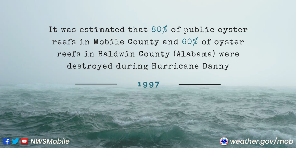
gauge. More than 100 people had to be evacuated from their homes on Sunday as the Fish River overflowed its banks.In Mobile County, most roads on Dauphin Island were covered with more than a foot of water. A CSX railroad trestle was undermined by flooding and collapsed at US Highway 90 and Ramsey Road. In Baldwin County, numerous roads south of US Highway 98 and near the Fish River were inundated and impassable for days. It was estimated that 80% of the Alabama public oyster reefs in Mobile County and 60% of the reefs in Baldwin County were destroyed. Along the Eastern Shore (Baldwin County) heavy rains caused landslides and a few homes were teetering on the edge of Mobile Bay. One home had to be relocated away from the edge of the bay to prevent loss.
The slow northward movement of Danny also caused extensive flooding across most of Choctaw County, AL. Rainfall totals of around 15 inches caused most streams in the county to come out of their banks. The heavy rains also caused extensive flooding of roads.
Here is a look at the rainfall map for the southeastern US during Hurricane Danny's lifetime. Photo courtesy of NCDC.
Table 1 - Storm Total Rainfall (inches) during Hurricane Danny
ALABAMA Dauphin Island Sea Lab 36.71 Malbis 33.00 Gulf Shores 30.00 Alabama Port 27.00 Bellefontaine 25.00 Fairhope 24.00 Daphne 23.54 Silverhill 22.50 Spanish Fort 20.10 Coden 19.67 Chickasaw 17.00 Mobile Regional Airport 13.04 FLORIDA Pensacola Regional Airport 6.78 Hurlburt Air Force Base 3.76
On the east end of Dauphin Island, the highest wind gusts were reported
just over 100mph with sustained winds of 70-80 mph. Inland at Mobile
Regional Airport, winds gusted to 45mph with sustained winds of 35mph.
Wind gusts from Fort Morgan to Orange Beach were estimated at
80-100mph.Most homes and businesses on Dauphin Island and buildings along the
western shore of Mobile Bay and homes from Fort Morgan east to Orange
Beach sustained some type of roof damage. A multi-story condominium
under construction near Gulf State collapsed. Numerous pecan and pine
trees were blown over with the most extensive damage being in Baldwin.
It was estimated that 70% of the Mobile pecan crop and 60% of the
Baldwin crop for 1997 was lost. High winds caused a ferry docked at
Fort Gaines to break away from its moorings. The runaway ferry destroyed
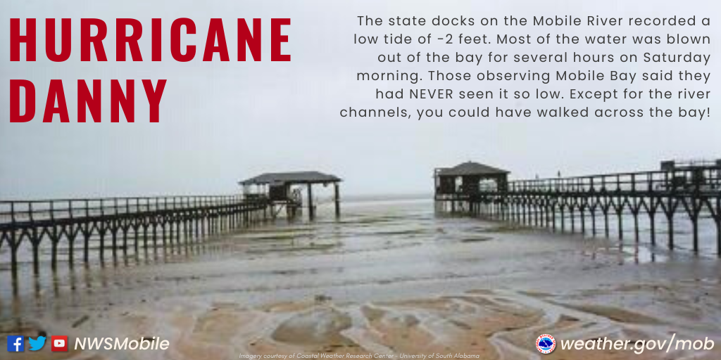
the catwalk from the Dauphin Island weather observation platform.The state docks on the Mobile River recorded a low tide of -2 feet. Most of
the water was blown out by the storm Saturday morning for several hours. People observing Mobile Bay said they had NEVER seen it so low. Except for the river channels, you could have walked across the bay!
A storm surge height of 5 feet was recorded in Dauphin Island Bay. The highest recorded surge during Danny was 6.5 feet in Baldwin County along Highway 182, halfway between Fort Morgan and Gulf Shores. 6 feet of salt water was inside historical Fort Morgan.
Table 2 - Observed storm surge data
Highway 182 (Fort Morgan Peninsula) Dauphin Island Bay 5.00 AL/FL State Line Bayou La Batre
Animations
Hurricane Danny Animated Radar (KMOB)
NCAR - Simulation of Hurricane Danny with Cloud Resolving Model
Imagery
NOAA Digital Coast - Hurricane Danny Track
CIMSS/UWM - Hurricane Danny Satellite Archive
US Naval Research Lab - Hurricane Danny Satellite Archive
LOCAL Damage Photos:
Mobile & Baldwin Counties - More Coming Soon!
More Information (Technical Papers and Assessments)
LOCAL RESEARCH PAPERS
Radar & Rain Gauge Analysis of the Extreme Rainfall during Hurricane Danny's (1997) Landfall
Authors: Jeff Medlin (NWS Mobile), Sytske Kimball & Keith Blackwell (University of South Alabama)
The Evolution of Hurricane Danny (1997) at Landfall: Doppler- Observed Eyewall Replacement, Vortex
Contraction/Intensification, & Low-Level Wind Maxima
Author: Keith Blackwell (University of South Alabama)
Coastal Weather Research Center - Hurricane Danny (University of South Alabama)
Monthly Weather Review - Atlantic Hurricane Season of 1997
WPC Summary - July 14-28, 1997
NCDC Special Report - Danny
NHC Tropical Cyclone Report - Danny
NWS Local Write-Ups and Webpages:
NWS Birmingham
NWS Atlanta
Acknowledgements: Page created by Morgan Barry (Forecaster) and Jason Beaman (WCM) with contributions from Jeffrey Medlin (MIC), Don Shepherd (Senior Forecaster, Tropical Focal Point) and Ryan Rogers (Forecaster).
LAST UPDATED: September 2022


 Follow us on YouTube