| Rainfall Summary: September 10-18, 2013 | |||||||||||||||||||||||||||||||||||||
|
The table below is a comprehensive list of the more significant precipitation reports that were received for the 9-day event period.
|
|||||||||||||||||||||||||||||||||||||
| Impact Summary | |||||||||||||||||||||||||||||||||||||
|
|||||||||||||||||||||||||||||||||||||
|
Hydrologic Summary
|
|||||||||||||||||||||||||||||||||||||
|
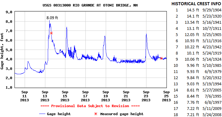
The Rio Grande at Otowi Bridge crested at 8.09 feet (8,080 cfs) at 1030am MDT September 13, 2013. This crest compares to a previous crest of 8.44 feet on July 6, 1995 and 7.76 feet on June 8, 1997. No flooding was observed along the Rio Grande however significant flows into the area from nearby creeks and arroyos created flooding around NM 502 and NM 30. Action stage is 8 feet, minor flood stage 9 feet, moderate flood stage 13 feet, and major flood stage 17 feet.
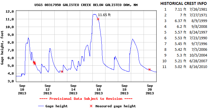
The Galisteo Creek at Rosario crested at 11.65 feet (2,920 cfs) at 200am MDT September 16, 2013. This crest is the highest crest on record for this location. The previous record crest was 7.11 feet set back on July 26, 1981. Significant attention was drawn by this crest as thousands of commuters along Interstate 25 were able to observe bank full and over bank flows in Galisteo Creek. Many people reported they had never seen the creek that high before and they were right! Action stage is 9 feet and minor flood stage 9 feet. There has been no determination of moderate and major flood stages for Galisteo Creek.
|
|||||||||||||||||||||||||||||||||||||
|
|
|||||||||||||||||||||||||||||||||||||


 Follow us on YouTube