Weather History - December 18th
Local and Regional Events:
December 18, 1985:
Bitter cold impacted most places in South Dakota as low temperatures dropped 20 degrees below zero or lower. The coldest temperature was 30 below zero at Huron in Beadle County and Canton in Lincoln County. Aberdeen dropped to 22 below zero, Highmore and Mobridge fell to 23 below zero; Britton fell to 24 below zero, and Summit bottomed out at 25 below.
December 18, 1996:
A powerful Alberta Clipper and a slow-moving deep Arctic high-pressure system brought widespread, prolonged blizzard conditions to the entire region from the 16th to the 19th. The clipper dropped from 1 to 5 inches of snowfall on top of the already extensive snow cover of 1 to almost 4 feet. Across central and north-central South Dakota, northerly winds increased to 25 to 40 mph with gusts to 55 mph late in the morning of the 16th. Temperatures also fell, and widespread blizzard conditions and dangerous wind chills of 40 to 70 below zero developed, prevailing through noon on the 18th. Across northeast South Dakota, conditions changed through late on the day of the 16th, with widespread blowing snow, falling temperatures, and dangerous wind chills. Blizzard conditions developed on the morning of the 17th and continued into the evening of the 18th. Conditions changed throughout the afternoon of the 16th in west-central Minnesota, with a full-fledged blizzard by the morning of the 17th.
North winds of 30 to 40 mph gusting to 50 mph brought visibilities near zero and caused heavy drifting, making travel difficult. Many people had to be rescued from their vehicles after getting stuck in massive snowdrifts or going into ditches because of low visibilities. Some people had to wait to be rescued for many hours, for some over a day. Due to the massive amount of blowing snow, widespread heavy drifting occurred across the entire area, blocking roads, making travel difficult, and leaving some people stranded to wait out the storm. Some snowdrifts from the storm were as high as 15 feet, with a few houses almost buried. A Burlington Northern locomotive became stuck in a 12-foot drift near Hazel and had to be dugout. Due to the weight of the snow, the roof of a hangar at the Gettysburg Airport collapsed on an airplane.
All schools were let out early on the 16th, with some schools not reopening until the 20th. Several school buses went into the ditch or got stuck in drifts and had to be pulled out. There were several accidents, most with minor injuries; however, one accident in Dewey County resulted in serious injury. Most of the roads, state highways and Interstate 90 were closed for a day or two until road crews could get to them. Interstate 29 also received heavy drifting, with parts of it closed for a while during the storm. Most snow plows had to be called back because they could not see the roads or the roads would be drifted over shortly after they were plowed. Some county snow removal budgets were already depleted or were close to being consumed. Emergency personnel and road crews were working extended hours to keep up with the storm. Rescue vehicles had a difficult time responding to emergencies. In one case, a lady from Mobridge had to be brought to Aberdeen. The 100-mile trip took six hours. Also, a rural Westport man died because the rescue units could not get to him in time.
Airports were closed, or flights were canceled or delayed. Mail was delayed for some people up to several days with a massive backup of Christmas packages. Some government offices and many businesses were closed for several days. All sports and other activities were postponed or canceled. Farmers and ranchers had a difficult time getting feed to their livestock. Many cattle were loose and had to be found as they walked on snowdrifts over fences. The storm also killed several animals and a countless number of pheasants with some buried in the snow. Several dairy producers had to dump thousands of pounds of milk because trucks could not get to them in time. Fortunately, there were only spotty power outages throughout the storm. For several hours on the night of the 16th in the extreme cold, 3000 people in Pierre were without power for several hours.
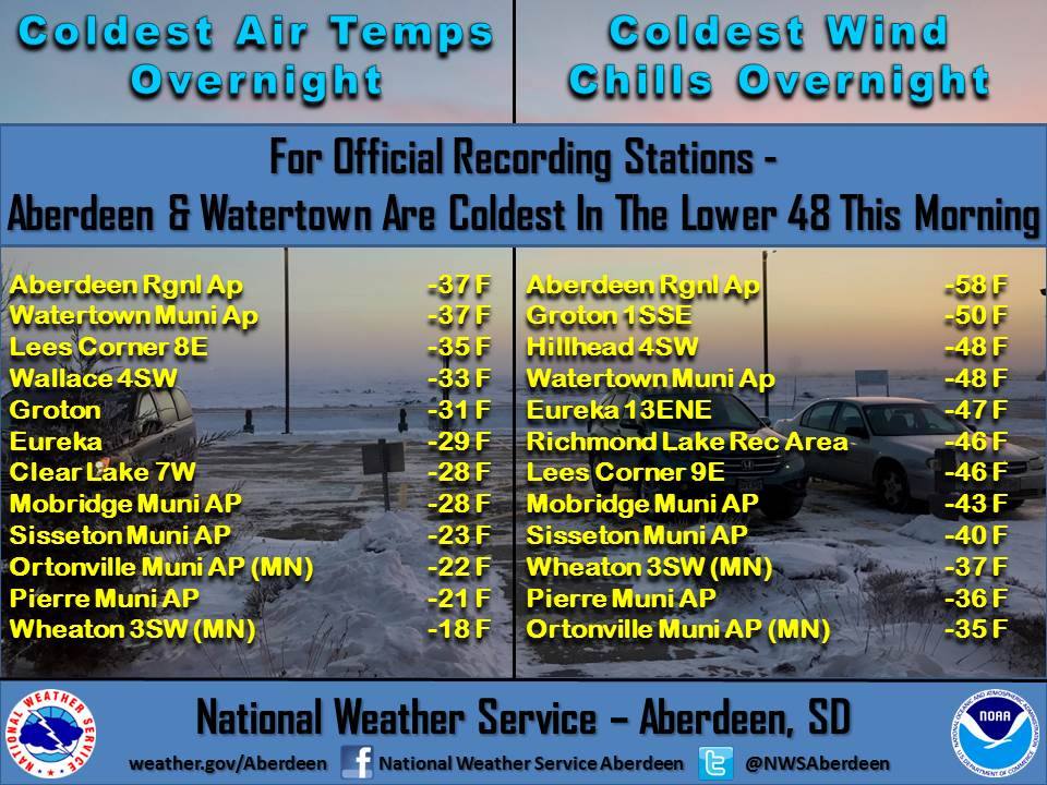
December 18th, 2016
An Arctic airmass over the Northern Plains produced bitterly cold temperatures. In South Dakota, both Aberdeen and Watertown broke their record low by several degrees, with both falling to 37 degrees below zero. The Arctic air combined with 10 to 20 mph winds brought wind chills to 35 to 60 degrees below zero across the region.
U.S.A and Global Events for December 18th:
1944: Typhoon Cobra, also known as the Typhoon of 1944 or Halsey's Typhoon (named after Admiral William "Bull" Halsey), was the United States Navy designation for a tropical cyclone that struck the Task Force 38 in the during World War II in the Pacific. The typhoon was first observed on December 17 as it surprised a fleet of ships in the open waters of the western Pacific Ocean. Sustained winds associated with the storm were up to 100 mph with gusts to 140 mph. On December 18, the small but violent typhoon hit the Task Force while many of the ships were attempting to refuel. Due to the extreme seas and winds, three destroyers capsized and went down with practically all hands, while a cruiser, five aircraft carriers, and three destroyers suffered serious damage. Approximately 790 officers and men were lost or killed with another 80 injured. This storm inflicted more damage on the Navy than any storm since the hurricane at Apia, Samoa, in 1889. In the aftermath of this deadly storm, the Pacific Fleet established new weather stations in the Caroline Islands and, as they were secured, Manila, Iwo Jima, and Okinawa. Also, new weather central offices (for coordinating data) were established at Guam and Leyte.
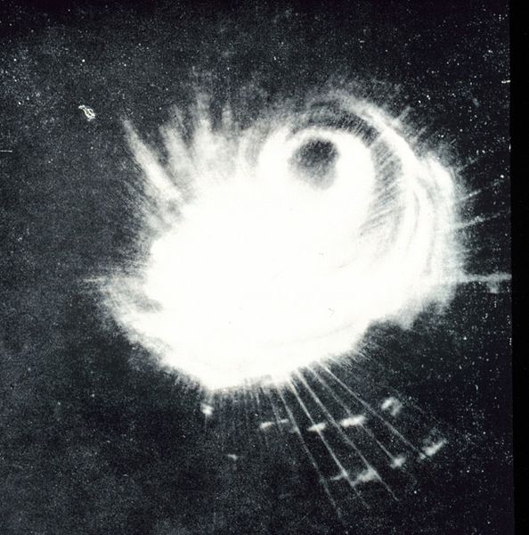
A Navy ship's radar captured the structure of a typhoon on December 18. This storm was the second tropical storm ever to be observed on radar East of the Philippine Islands.
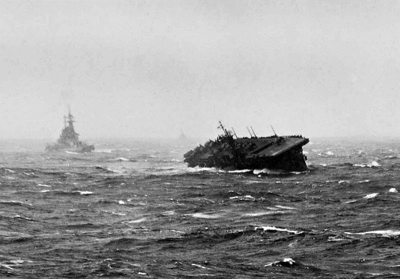
The U.S. Navy light aircraft carrier USS Langley (CVL-27) rolling heavily during Typhoon Cobra, 18 December 1944. A battleship is steaming behind the carrier. U.S. Navy (the image is part of an album of photographs collected by Captain Carlos W. Wieber during his command of the aircraft carrier USS Essex (CV-9) during 1944-1945).
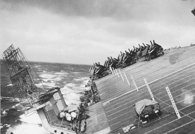
A view of USS Cowpens (CVL-25) starboard side flight deck facing aft from the island. The photo was taken at the time Typhoon Cobra hit the Third Fleet on 18 December 1944.
1986: A strong winter storm, which developed off the coast of New Jersey and moved out to sea, lashed the northeastern U.S. with high winds, heavy rain, and heavy snow. The storm left snowfall amounts of up to 30 inches in Vermont, 24 inches in Massachusetts, and 20 inches in New Hampshire. The highest rainfall amounts approached four inches in southern New England, where winds gusted to 70 mph.
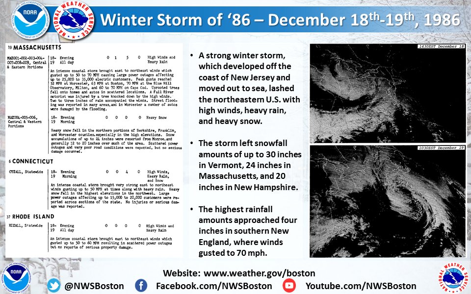
The image above is from a Tweet by the NWS Office in Boston, Massachusetts.
Click HERE for more This Day in Weather History from the Southeast Regional Climate Center.


 Follow us on YouTube