|
The National Weather Service in Birmingham is offering GIS data from storm surveys following severe weather events that unfold across central Alabama. These data offer survey information from tornado tracks that are found by damage assessment teams in the field. The links below contain information for all 11 tornadoes that have been surveyed across the State of Alabama that formed on January 23, 2012. Most information was produced and extracted from the National Weather Service Damage Assessment Toolkit, which has been developed by National Weather Service Meteorologists to modernize storm survey information into a geospatial format for the general public and GIS analysts. The information can be passed along to decision makers and the emergency management community after storm surveys have been completed.
ESRI Shapefiles: 
All Tornado Paths - (Updated 2/1/12) Zipped folder contains line shapefiles of all 11 tornado tracks that occurred on January 23, 2012. Attribute information includes: Tornado Name, EF-Scale, Peak Wind, Start Time, Beginning and Ending Latitudes and Longitudes, End Time, and maximum width in yards. Shapefile projections are in Universal Transverse Mercator Zone 16N.
All Survey Points - (Updated 2/1/12) Zipped folder contains point shapefile locations within specific tornado paths that include detailed survey information gathered from assessment teams in the field. The attribute information includes: Event Date, Survey Date, Damage Indicator, Degree of Damage, EF-Rating at the point location, Wind Speed, Comments from the survey team regarding specific damage information, and the Tornado associated with the survey point. Shapefile projections are in Universal Transverse Mercator Zone 16N.
All Tornado Swaths - (Updated 2/1/12) Zipped folder contains polygon shapefiles of estimated damage swaths of surveyed tornadoes. Shapefile projections are in Universal Transverse Mercator Zone 16N.
Attention GIS Analysts Using ArcGIS: Please view the metadata within ArcCatalog to view a complete description of shapefile information. (Metadata Posted 2/1/12)
Google Earth KMZ Files: 
Tornado Survey Information KMZ (Posted 1/31/12) Google Earth KMZ contains all the detailed storm survey information gathered for the 11 tornadoes in the Birmingham County Warning Area. In select locations, damage photographs taken by assessment teams can also be viewed. Be advised that this information is still deemed as experimental. The information was extracted from the National Weather Service Damage Assessment Toolkit.
Interactive Map - Tornado Paths and Survey Points:
The map below presents an interactive view of tornado paths and survey locations collected by damage assessment teams in the field. Many of these same points can be downloaded using the links for the Paths and Survey Point Shapefiles above. To see information from the survey points, zoom in to the specific point of interest and click on the point. A pop-up box will appear with specific survey information. Damage photographs, if they are available, can be viewed by scrolling to the bottom of the pop-up. Click on a damage photo to enlarge on a separate tab. If several features appear within a close proximity to one another, look for the "Next Feature" button (>) on the top right of the pop-up to view each feature. To zoom in and out, use your mouse wheel or use the plus and minus buttons in the top left corner of the map. Once again, these data are experimental and preliminary.
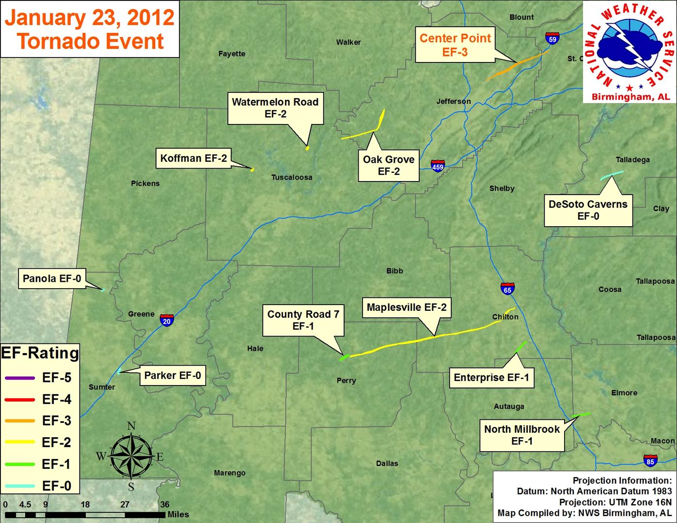
Event Map:
11 tornadoes have been confirmed from January 23rd. By clicking on the tornado names below, you will be taken to detailed survey information regarding the tornado of interest.
|


 Follow us on YouTube