Central Alabama Gradient Winds with Strong Cold Front
January 29th & 30th, 2008
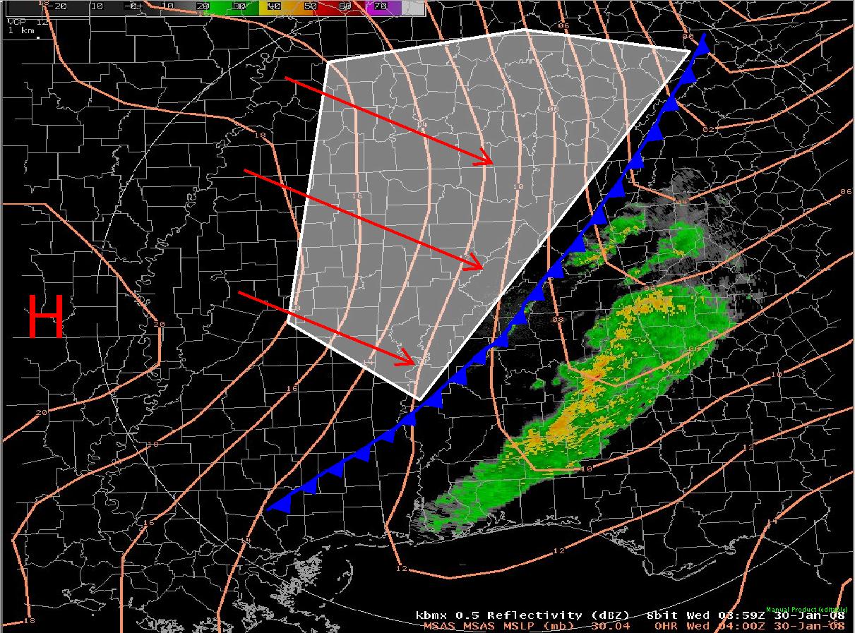
A strong cold front entered northwest sections of Central Alabama during the evening hours on January 29th and exited southeast sections of Central Alabama during the early morning hours on January 30th. As the front moved across the area, the pressure increased some 7 to 10 mb in a 3 hour period behind the front. This pressure change created gradient winds of 35 to 45 mph, with a few gusts over 50 mph. Trees and power lines were blown down in numerous locations. Some of the counties reporting damage included; Lamar, Pickens, Tuscaloosa, Jefferson, Blount, Shelby, Etowah, Tallapoosa, Lowndes, Dallas, Walker, Cherokee, St. Clair and Calhoun. Ahead of the front, high temperatures soared well above normal ranging from the middle 60's to lower 70's. As the front moved through, temperatures dropped some 20 to 25 degrees. Low temperatures ended up ranging from the middle 20's to lower 30's. The strongest winds occurred behind the front after most of the rain had ended. Figure 1 depicts the pressure gradient between high pressure on the left of the image and low presusure along the front. Surface winds blow from high pressure toward low pressure usually near parallel to the lines of equal pressure (isobars). In this case, the winds were were nearly perpendicular to the isobars indicating considerable density differences between the air masses on either side of the front. Figure 2 depicts the magnitude of the 3 hour pressure rises behind the cold front. Click the images for a larger picture.
Figure 1 - Pressure Gradient Image
Figure 2 - Pressure Change Image
Location Unofficial Maximum Wind Gust Near Northport 68 mph Daniel Building in Downtown Birmingham 65 mph Shades Mountain 63 mph Cordova 57 mph Inverness 56 mph Birmingham International Airport 55 mph Attalla 55 mph Helena 53 mph Alabaster 51 mph Bear Creek 51 mph Hamilton 51 mph Nauvoo 50 mph Vance 49 mph Shelby County Airport 48 mph Troy 47 mph Springville 45 mph Maxwell Air Force Base Montgomery 45 mph Tuscaloosa 44 mph Southeast Tusclaoosa 43 mph Jasper 43 mph Clay 43 mph Crestline 41 mph Gadsden 40 mph Anniston 40 mph Odenville 37 mph Haleyville 36 mph Guin 36 mph Childersburg 36 mph Montgomery 35 mph Alexander City 32 mph PRELIMINARY LOCAL STORM REPORT...SUMMARY NATIONAL WEATHER SERVICE BIRMINGHAM AL 1203 AM CST WED JAN 30 2008 ..TIME... ...EVENT... ...CITY LOCATION... ...LAT.LON... ..DATE... ....MAG.... ..COUNTY LOCATION..ST.. ...SOURCE.... ..REMARKS.. 0745 PM NON-TSTM WND DMG VERNON 33.76N 88.11W 01/29/2008 LAMAR AL EMERGENCY MNGR NUMEROUS TREES AND POWER LINES DOWN IN VERNON AND ACROSS THE COUNTY. TREES DOWN ON TWO HOUSES. 0845 PM NON-TSTM WND DMG TUSCALOOSA 33.24N 87.54W 01/29/2008 TUSCALOOSA AL EMERGENCY MNGR SEVERAL TREES AND NUMEROUS POWER LINES DOWN IN TUSCALOOSA...AND NORTHWARD ACROSS THE COUNTY. 0858 PM NON-TSTM WND GST 4 SSE TUSCALOOSA 33.18N 87.51W 01/29/2008 M43.00 MPH TUSCALOOSA AL EMERGENCY MNGR 43 MPH GUST IN TAYLORVILLE. 0901 PM NON-TSTM WND GST TUSCALOOSA 33.24N 87.54W 01/29/2008 M39.00 MPH TUSCALOOSA AL ASOS GUST TO 39 MPH RECORDED AT THE TUSCALOOSA AIRPORT. 0901 PM NON-TSTM WND GST NORTHPORT 33.24N 87.59W 01/29/2008 M42.00 MPH TUSCALOOSA AL EMERGENCY MNGR WIND GUST TO 42 MPH. 0920 PM NON-TSTM WND DMG BIRMINGHAM 33.53N 86.80W 01/29/2008 JEFFERSON AL EMERGENCY MNGR NUMEROUS TREES AND POWER LINES DOWN IN BIRMINGHAM...AND ACROSS MUCH OF JEFFERSON COUNTY. 0920 PM NON-TSTM WND GST BIRMINGHAM 33.53N 86.80W 01/29/2008 E55.00 MPH JEFFERSON AL ASOS 55 MPH GUST RECORDED AT THE BIRMINGHAM AIRPORT 0920 PM NON-TSTM WND DMG 5 SSW LOCUST FORK 33.84N 86.65W 01/29/2008 BLOUNT AL EMERGENCY MNGR TREES DOWN ON RESIDENCE. 0930 PM NON-TSTM WND DMG CHELSEA 33.33N 86.64W 01/29/2008 SHELBY AL BROADCAST MEDIA CAR RAN INTO TREES DOWN ON HIGHWAY 39. POSSIBLE INJURIES. 0935 PM NON-TSTM WND DMG 4 NE BLOUNTSVILLE 34.12N 86.54W 01/29/2008 BLOUNT AL EMERGENCY MNGR TREES DOWN ALONG COUNTY HWY 49 BETWEEN US 231 ANS AL 79. 0935 PM NON-TSTM WND DMG ONEONTA 33.95N 86.47W 01/29/2008 BLOUNT AL EMERGENCY MNGR TREES DOWN IN ONEONTA. 0940 PM NON-TSTM WND DMG BLOUNTSVILLE 34.08N 86.59W 01/29/2008 BLOUNT AL EMERGENCY MNGR TREES DOWN IN MULTIPLE LOCATIONS COUNTYWIDE. 0940 PM NON-TSTM WND DMG 2 NW HUEYTOWN 33.46N 87.02W 01/29/2008 JEFFERSON AL FIRE DEPT/RESCUE CONCORD FIRE DEPARTMENT REPORTS TREES BLOCKING CAMP OLIVER ROAD. 0940 PM NON-TSTM WND DMG 3 NE HAYDEN 33.93N 86.72W 01/29/2008 BLOUNT AL EMERGENCY MNGR TREES REPORTED DOWN. 0945 PM NON-TSTM WND DMG COLUMBIANA 33.18N 86.60W 01/29/2008 SHELBY AL EMERGENCY MNGR NUMEROUS REPORTS OF TREES DOWN AND SCATTERED POWER OUTAGES COUNTY WIDE. 0955 PM NON-TSTM WND DMG GADSDEN 34.01N 86.01W 01/29/2008 ETOWAH AL EMERGENCY MNGR NUMEROUS REPORTS OF TREES DOWN AND SCATTERED POWER OUTAGES ACROSS THE COUNTY. 0955 PM NON-TSTM WND DMG GADSDEN 34.01N 86.01W 01/29/2008 ETOWAH AL EMERGENCY MNGR TREES ACROSS THE ROAD ON VALLEY STREET IN DOWNTOWN GADSDEN. 1050 PM NON-TSTM WND DMG ALEXANDER CITY 32.93N 85.93W 01/29/2008 TALLAPOOSA AL EMERGENCY MNGR REPORTS OF TREES DOWN ON 2 HOUSES WITHIN THE CITY LIMITS. 1055 PM NON-TSTM WND DMG WHITE HALL 32.30N 86.71W 01/29/2008 LOWNDES AL EMERGENCY MNGR POWER LINES DOWN AROUND CITY HALL. 1102 PM NON-TSTM WND DMG MOSSES 32.18N 86.67W 01/29/2008 LOWNDES AL EMERGENCY MNGR NUMEROUS BRANCHES DOWN ACROSS THE COUNTY...ALONG WITH POWER OUTAGES. 1102 PM NON-TSTM WND DMG SELMA 32.42N 87.03W 01/29/2008 DALLAS AL EMERGENCY MNGR NUMEROUS TREES DOWN ACROSS THE COUNTY. POWERLINES DOWN 1 MILE WEST OF 80W AND AL HWY 14W. 1102 PM NON-TSTM WND DMG 10 NE SELMA 32.52N 86.91W 01/29/2008 DALLAS AL EMERGENCY MNGR SEVERAL TREES DOWN ALONG HIGHWAY 22 IN PLANTERSVILLE BLOCKING THE ROAD 1102 PM NON-TSTM WND DMG SELMA 32.42N 87.03W 01/29/2008 DALLAS AL EMERGENCY MNGR TREE BLOCKING ROAD ON BROAD STREET IN DOWNTOWN SELMA. TREE DOWN ON OLD MONTGOMERY HIGHWAY NEAR SELMONT WATERWORKS. && $$


 Follow us on YouTube