Introduction
On January 22, 1999 a line of thunderstorms was moving from Mississippi into western Alabama. At the same time, there were three gravity waves moving northward through Alabama. The waves were about 25 miles apart and all were detectable on radar. The third, and last in the series, was most noticeable. This third wave, as it passed through one of the thunderstorms, may have helped in the formation of an F0 tornado that touched down in northern Fayette County. It is this strongest wave that will be briefly looked at here.
This E-Poster is not intended to be a detailed study of this event. It simply presents a small bit of evidence for a gravity wave/thunderstorm interaction, and makes a few suggestions.
The Wave
It is not known where the gravity waves originated, but they can be detected over south Alabama during the late morning, and an analysis of surface pressure at 17z showed a weak, but detectable, nearly east-west trough across south Alabama. This trough may represent these three gravity waves. Around 20z, radar shows the stronger wave passing Montgomery, and a corresponding jump can be seen in the pressure near that time. Just before 21z, the wave can be seen on radar passing Birmingham. A graph of pressure at BHM also shows an abrupt jump, then fall, in the pressure near the time the wave passes. One and five minute data were not available, but the hourly and special observations may have provided enough evidence to suggest there was a gravity wave passage.
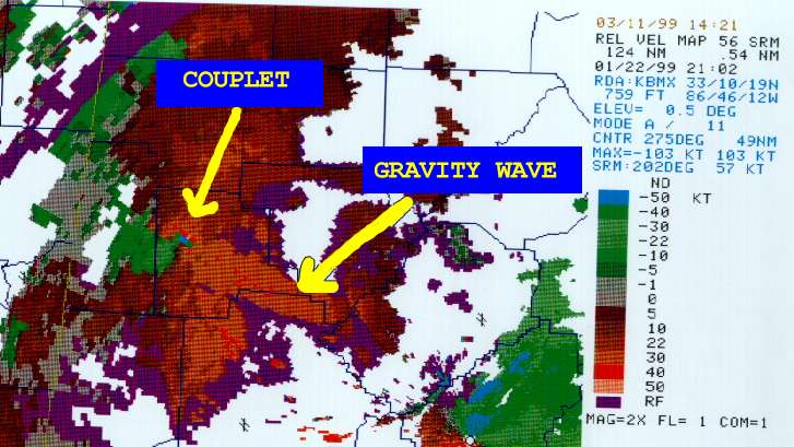
Here are three images showing the gravity wave at different locations as it moves northward. The wave is indicated by the red arrow. In image one the wave was near southern Perry County, in image two the wave was over Tuscaloosa County, and in image three it was over Fayette and Walker Counties. Around the time of image three , the wave was already interacting with a thunderstorm over Fayette County, and the rotational velocity was increasing. At 2102z, the 0.5 degree SRM shows the wave aligned with a small rotational couplet, indicated by the yellow arrows. Shortly after this, a small (F0) tornado touched down over northern Fayette County.
If you look closely at a loop of the base reflectivity , you can follow the wave from Perry County until it interacts with the thunderstorm over northern Fayette County, then continues into Marion and Winston counties. The time period of the loop was 1903z through 2138z. A careful analysis of the movement of the wave shows that it was traveling north at 67 mph (58 kts). That is considerably faster than the mean 0-3 km flow of 49 kts, as shown on the 00z BMX sounding. I believe the available data, and the fact that the wave was a low level feature moving at 67 mph, is evidence enough that this was indeed a gravity wave.
Conclusion
It was noted during this event that each time one of the gravity waves passed through a thunderstorm, the storm became more intense and the rotational velocity increased. It is likely that this interaction of the stronger gravity wave with the thunderstorm, is what caused the small tornado. The gravity waves were detectable on the radar, with reflectivities generally less than 20 DBZ, and in the case of the strongest one more than 35 DBZ. These features could be tracked across more than one half of the state. Other severe weather episodes such as Palm Sunday 1994, and April 8, 1998, may have also had a gravity wave connection. The gravity wave may be a more important feature in tornado development than previously thought.


 Follow us on YouTube