|
Tornadic Debris Signature from Dual Polarization Radar
|
|
In February of this year, the National Weather Service (NWS) upgraded the Birmingham radar from single polarization to dual polarization. One of the advantages of the dual pol radar upgrade is the ability for the NWS to detect tornadic debris. It must be understood, though, that dual pol does not give us advanced warning. Rather, a tornadic debris signature means that a tornado potentially has already been (or is currently) on the ground. It gives us the ability to confirm the potential of a tornado touching down. Additionally, debris doesn't necessarliy mean pieces of buildings. It could just be leaves and dirt that has been lifted into the atmosphere. These debris signatures are helpful in multiple ways. First, it gives us the potential to know if a tornado is on the ground at night, when people are sleeping and there are no damage reports coming into the office. We can increase the intensity of the wording in the tornado warnings, hopefully springing people into action and taking shelter. Secondly, it gives us the possible location of where damage may have occurred when the damage is in a very rural area. This helps when we are conducting storm damage surveys. In the following images, we want to illustrate to you how we see it here in the office during severe weather operations.
On the morning of Monday, October 1st, environmental conditions across central Alabama became right for the spin up of one short-lived tornado. The EF-0 tornado was on the ground for 2 minutes, uprooting trees and causing damage to a couple of outbuildings in southern Coosa county. Because the tornado occurred at 445 am and the area was very rural, we did not receive any word of damage in real time. The first two images below are radar images just before the tornado touched down. Notice in the image on the left, the rotational couplet (87 knots), within the white circle. Correspondingly, the image on the right is of Correlation Coefficient (CC). A reduction of CC is indicative of tornadic debris. Notice in the white circle, the values of CC are fairly uniform, showing no lofted debris just yet.
|
|
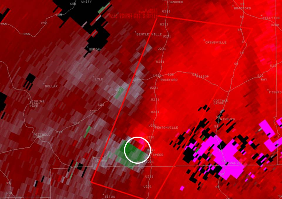
This is an image of the 0.5 degree velocity (SRM) data from KMXX at 445 am just before the weak tornado touched down southeast of Pentonville.
|
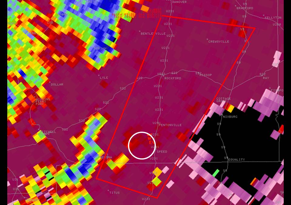
This is an image of the 0.5 degree Correlation Coefficient (CC) data from KBMX at 445 am as the tornado touched down southeast of Pentonville.
|
|
|
By the time the following radar scan comes in, at 450 am, the tornado has already touched down and lifted. Notice in the velocity image on the left, the rotational couplet has weakened. There are a few gate-to-gate pixels, but with only 30 knots of rotational velocity, this far from the radar, the circulation is weak at best. But, now notice in the CC on the right. The values are beginning to decrease, shown by the arrow. Debris that has been lifted into the atmosphere is causing this decrease in CC (0.91 - 0.92). It is imperative that this signature be co-located with the rotational couplet, no matter how weak it may be.
|
|
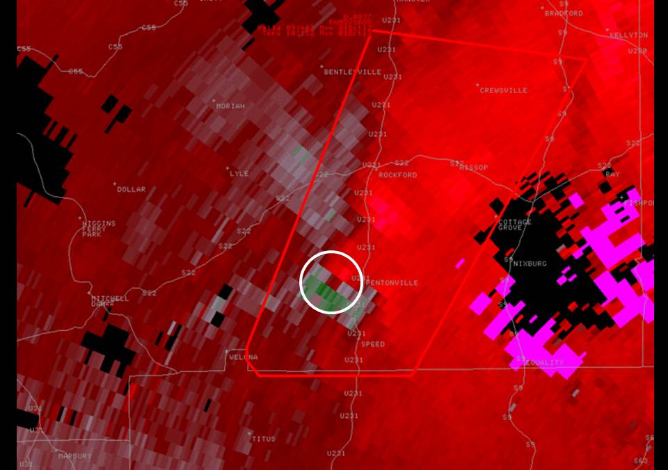
This is an image of the 0.5 degree velocity (SRM) data from KMXX at 450 am just after the tornado had lifted. Notice the weakening of the couplet. The tornado has already done its damage.
|
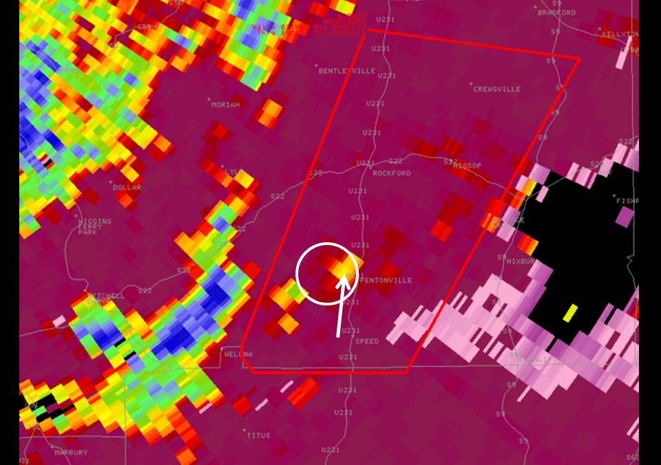
This is an image of the 0.5 degree Correlation Coefficient (CC) data from KBMX at 450 am just after the tornado had lifted. Notice the decrease in CC inside the white circle.
|
|
|
In the final two images, which are from 455 am, we see an even weaker rotational couplet (20 kts), but now look at the CC (0.85 - 0.91). It has decreased even further. Again, at this point, we have received no reports of damage, but now, there is a good feeling that a tornado has touched down. The debris signature with this couplet gained an altitude of almost 9000 ft. Pretty incredible when you think this was only an EF-0 tornado.
|
|

This is an image of the 0.5 degree velocity (SRM) data from KMXX at 455 am well after the tornado has lifted. Notice there is no rotational couplet.
|

This is an image of the 0.5 degree Correlation Coefficient (CC) data from KBMX at 455 am well after the tornado has lifted. Notice the decrease in CC from the previous scan.
|
|
|
With very sparse damage reports by the late morning hours, our survey team was able to locate damage because of this information. For more on what occurred, you can visit our survey page from this tornado by clicking here.
|
|


 Follow us on YouTube