 |
||||||||||||
|
||||||||||||
| Be Prepared for Hurricanes, Anytime 2017 Awareness Week is May 7th through 13th! |
||||||||||||
|
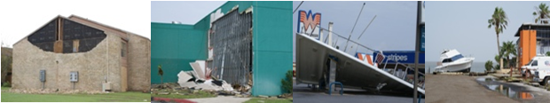
The 2016 Atlantic Hurricane Season finally broke the streak of "quiet" U.S. seasons based on direct impacts from storms, which had lasted four years (2012 – the last time two or more hurricanes had a direct impact on U.S. shores). Labor Day Weekend’s Hermine was the first Gulf of America Hurricane since 2013’s Ingrid, breaking a nearly three-year Gulf hurricane drought. Hermine will be remembered for the highest storm surge water depth on Florida’s Nature Coast (north of the Tampa Bay area) in decades. A month later, Major Hurricane Matthew became a Category 5 windstorm at the farthest south latitude on record for the Atlantic basin, before making a sharp north turn in the central Caribbean. Matthew would ravage the west end of Haiti, producing damage in the billions of damage and killing more than 500. Slightly weakened but still devastating Category 4 Matthew caused extensive damage in the western Bahamas before taking aim at Florida’s Atlantic coast, but would stay just offshore, with the western eyewall clipping Cape Canaveral with wind gusts between 103 and 107 mph. After producing significant but not devastating wind and storm surge along the Atlantic coast from Florida through southeast North Carolina, Matthew’s memory transitioned into one of devastating rainfall flooding in southern North Carolina, where Matthew’s rainfall was enhanced by atmospheric lifting and compounded by saturated soils prior to arrival, some the result of rainfall from Hermine. In all, Matthew cost more than $16 billion in property damage, including $10 billion in the United States. Direct deaths from the hurricane were last reported at 585 persons. Earl: A Close Call in 2016 for the Valley Previous Recent Years of Interest Isaac was the prelude to the monster that would effectively close the season with a bang. Hurricane Sandy interacted with big atmospheric puzzle pieces, including a deepening upper level trough moving into the Ohio Valley, and a westward building upper level ridge across the northwest Atlantic Ocean. Close to the surface, the cyclone enveloped abundantly warm, moist air from above average Gulf Stream waters. This combination allowed the storm to take a very rare west–northwest track (for late October) onto the New Jersey coast. All the while, Sandy was barely hanging on as a Category 1 wind storm. The rest is history. Sandy usurped 1991’s Perfect Storm when it grew to more than 900 miles wide, surged up to 9 feet of Atlantic Ocean waters and pounding waves along the New Jersey and New York City shoreline, and dropped up to three feet of snow in the mountains of West Virginia. More than $65 billion in damage was estimated, and at least 8 million residents were without power for days to weeks into the chill of a northeast U.S. November. Closer to home, tropical activity was non existent in 2012. Wind shear and dry air from northern Mexico through Texas locked the door to all system’s attempt to move toward the Rio Grande Valley. The closest point of impact was near Tampico with Tropical Cyclone Helene in mid August, which made "landfall" as a barely noticeable depression. With tropical activity far removed from the Rio Grande Valley and Rio Grande basin, heat dominated the summer and drought worsened steadily after a temporary break between late March and mid May. The 2010 season is remembered for Hurricane Alex Alex produced tropical storm force winds, moderate rainfall, and feeder band tornadoes on June 30th, and leftover tropical moisture and turning winds helped produce a damaging tornado in Hebbronville. The storm’s remnants were most memorable, as more than 50 inches of rain fell across the Mexican tributaries of the Rio Grande basin through July 2nd. The result was a massive river flood and opening of the floodways in the Valley, which continued for the better part of July and August. Two months later, the Brownsville/Harlingen/Raymondville area took a direct hit from rapidly developing Tropical Storm Hermine, which left millions of dollars in damage from 70 mph winds on Labor Day night. Though Hermine was the final cyclone to affect the Valley in 2010, moisture initially associated with Hurricane Karl (which slammed into Veracruz in mid September) aided a period of heavy rainfall and flooding in mid September. In 2008, Texas experienced what the State of Florida had become accustomed to earlier this decade: A very busy Hurricane Season. Four storms, ranging from Edouard’s light touch to Ike’s deadly hammer, affected millions of Texans living near the coast, from the Lower Rio Grande Valley to the Beaumont and Port Arthur area. When the waters cleared and the debris was removed, an estimated $20 billion or more in damage was realized, along with more than 100 fatalities directly or indirectly from the storms. Hurricane Dolly provided a much needed wake up call to the Rio Grande Valley, after a number of near misses and a general complacency since Beulah made the last direct hit on the main population centers back in 1967. Flooding rains exposed a patchwork of poor drainage locations from Cameron and Willacy through Hidalgo and Starr Counties. Category 1 sustained winds raked South Padre Island, knocking out power for up to two weeks and leaving a mess of debris that effectively halted the normally busy mid summer resort season. What will the 2017 season bring? No matter what the forecast, it only takes one landfalling hurricane to make a season memorable. Preparedness is the key to surviving any hurricane season, and we hope the following information, along with that in the Texas Hurricane Guide, Rio Grande Valley Edition will help residents of the Rio Grande Valley and Deep South Texas to make smart decisions well before any storms arrive on our shores. What you do now may well save your life, your family, and protect your property from the perils of hurricanes, this year and any year. |
||||||||||||
|
||||||||||||
| Other Links
Know Your Flood Risk
|
||||||||||||

