 |
|||||||||
|
|||||||||
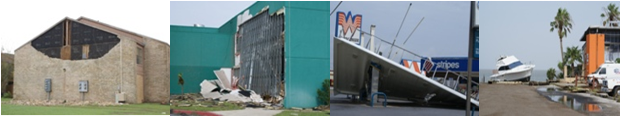
| Hurricane Preparedness for the RGV |
|||||||||
|
Tropical Storm Hermine’s Midnight Madness reminded boaters and fishers just how important it is to have a plan to return quickly to safe harbor at any time during Hurricane Season. The development of near hurricane force gusts and 20 foot confused seas near the mouth of the Rio Grande from a nebulous blob of rain across the Bay of Campeche in little more than 24 hours was a testament to the power of nature over the waters that mariners and others love to enjoy. If venturing out in the western Gulf anytime this Hurricane Season, be sure to keep abreast of the latest weather reports and forecast by tuning into NOAA Weather Radio via VHF or other channels within 60 nm of the coast. There is no single rule of thumb that can be used by mariners to ensure at least minimum safe separation from a tropical cyclone. Constant monitoring of tropical cyclone potential and a continuing risk analysis, when used with some fundamental guidelines, are the basic recommended tools to help minimize the impact of a tropical cyclone to a vessel at sea or in port. One rule is paramount: Avoiding the 34 knot (gale force) wind field of a tropical cyclone. Any ship in the vicinity of a tropical cyclone should make every effort to remain clear of the maximum radius of analyzed or forecast 34 knot winds. A second common sense rule is to never cross the "T"(the track) of a tropical cyclone. Finally, consider the 1-2-3 Rule for avoiding winds associated with a tropical cyclone. This rule accounts for the average forecast track error over a 10 year period which is approximately 100 nm in 24 hours, 200 nm in 48 hours, and 300 nm in 72 hours. More details can be found here. Sudden acceleration or intensification of a cyclone can put a ship in harm’s way, so constant adjustments in navigation are critical, since a storm’s track, size, and intensity are always in flux. Mariners must be cautioned never to leave themselves with only a single navigation option when attempting to avoid a tropical cyclone in the Atlantic basin. Having room to maneuver at sea can become extremely important when operating in the confined waters of the western Caribbean Sea and Gulf of Mexico. Obtain the latest Marine Prediction Center and Tropical Prediction Center analysis and forecast charts, including surface, upper level, and sea state charts. Locate and plot tropical waves, disturbances, and tropical cyclones. If available, examine current satellite imagery. Obtain the latest tropical cyclone advisory messages. Plot current and forecast positions of all active and suspected tropical cyclone activity. Make a chart of the tropical cyclone danger areas to avoid. Determine possible courses of action, at least two, for your vessel to take in order to remain clear of the danger. Evaluate current and nearby port and hurricane haven locations that may be considered for tropical cyclone avoidance. Make a decision on a course of action to follow, and execute it. Continue to closely monitor the progress of any tropical cyclones. Ensure that all maritime charts are up to date for the 2009 season. Geographic information systems (GIS) offer pinpoint mapping detail for surface and sub surface markers, so consider this option as well. For additional information regarding marine related preparedness during the hurricane season, click here. |
|||||||||

