 |
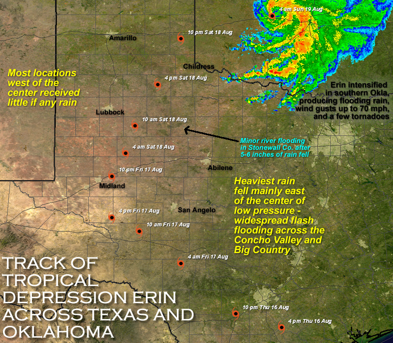
After a relatively warm and dry spell (for the summer of 2007), tropical moisture, in the form of remnants from once Tropical Storm Erin, brought large amounts of rain to portions of western Texas. This rain fell primarily on the 17th and 18th of August on the South Plains and Rolling Plains before spreading northeast into Oklahoma on the 19th. This storm was particularly impressive in the fact that it maintained its circulation well after making landfall, even re-strengthening dramatically over central Oklahoma early on Sunday, the 19th. However, the storm didn't bring rainfall to everyone, as there was a sharp cutoff in rainfall west of the storm track - much of the western South Plains remained dry.
The following image shows the approximate track of Erin as it traversed the region.
 |
|
Map showing the track of Erin as it moved across Texas and into Oklahoma - please click on the image for a larger version
|
Below is an image displaying the approximate distribution of the rain that fell as a result of Erin moving through the region. The heaviest rainfall in the area fell to the south and east of Lubbock across the Rolling Plains, with amounts quickly cutting off north and west of Lubbock. The largest rainfall total recorded in the Lubbock NWS forecast area was 6.10 inches, observed by the West Texas Mesonet site 3 miles northeast of Aspermont. However, 2-4 inches of rain was fairly common over many location to the east of Lubbock. Click on the below map for a larger version.
 |
|
Map showing the total rainfall (in inches) that Erin produced as it moved across the region. The rain fell across the South Plains on the 17th and 18th of August 2007. Rainfall data are courtesy of the West Texas Mesonet, NWS COOP and NWS ASOS sites - please click on the image for a larger version
|


 Follow us on YouTube