Deadly Tornado in Jacksonville, NC, July 2, 1986
SUMMARY
An EF-2 tornado touched down around 8:30 pm on the evening of July 2, 1986 at the former Triangle Trailer Park in Jacksonville, NC (Figure 1). Three people were killed in this tornado with 10 people injured. Ten mobile homes were destroyed and 20 others were damaged. The storm touched down twice in a 1.5 mile path that was 33 yards wide, and moved east-northeast. Further to the east in Onslow County, windows were blown out and an outbuilding was destroyed in Hubert. Total property damage from this storm in Onslow County was $500,000. Interestingly, 1986 was a relatively quiet year for tornado fatalities across the United States, but this tornado was the deadliest single tornado of the year in 1986 (Figure 2).

Figure 1. Present Day map showing location of July 2, 1986 (Triangle Trailer Park).

Figure 2. 1986 Tornadoes (Deaths in parentheses).
More Details
The Jacksonville tornado was part of a fairly large severe weather outbreak across eastern North Carolina during the afternoon and evening hours of July 2, 1986. The severe thunderstorms started in western and northern sections of eastern North Carolina during the late afternoon hours. Trees were blown across roads in Martin County, and a house under construction was damaged at Nags Head. At Pea Island, a full dumpster was blown across a parking area. The severe storms developed south by early evening and increased in coverage with trees snapped and roofs damaged near Comfort in Jones County around 625 pm. In southern Duplin County, substantial damage to homes from falling trees was reported as winds were estimated around 70 mph.
A deep (for July) mid-level trough was in place at 500 mb (Figure 3). At the surface, a warm moist southerly flow was in place ahead of a cold front that would cross the area and be just offshore by the early morning hours on July 3 (Figure 4). With a humid airmass in place, this setup likely produced sufficient shear to produce the short-lived tornado along the frontal boundary during the evening of July 2, 1986.
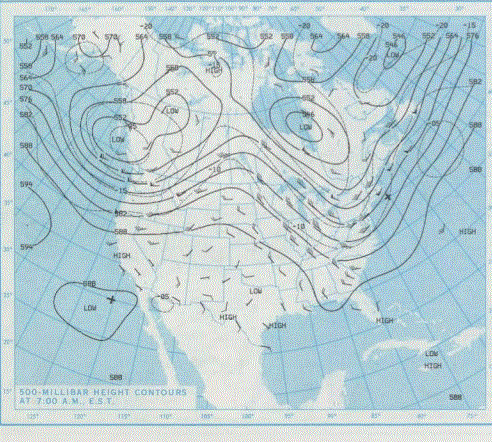
Figure 3. 500 MB Analysis at 7 AM July 2, 1986 showing deep trough across the southeast United States.

Figure 4. Cold front has moved offshore as of 7 AM, July 3, 1986.
Article (Courtesy Associated Press)


Sources
Weather Prediction Center Daily Weather Maps
The Tornado Project
National Climatic Data Center Local Storm Reports
Associated Press


.png) Surf Forecast/Rip Currents
Surf Forecast/Rip Currents Map View
 Weather Hazard Briefing (when applicable)
 Forecaster Discussion
 Marine
 Text Products
.png) Skywarn
Skywarn Submit Storm Reports
 Coastal Flood
 Follow us on YouTube