
North Central Gulf Coast Heavy Rain Event
October 26-27, 2015
A strong area of low pressure, associated with the remnant moisture of Hurricane Patricia, affected the northern Gulf Coast in late October (the 25th-27th). The pressure gradient between the area of low pressure and high pressure centered over Lake Ontario resulted in strong southeasterly flow across the region. Precipitable water (a measure of the moisture content in the atmosphere) was around 2 inches on the morning of the 26th across lower Alabama and the Florida panhandle; a value nearly 2 standard deviations above normal for this time of year. Strong onshore winds also resulted in waves of over 10 feet, strong rip currents and considerable coastal flooding across the region.


Heavy Rainfall
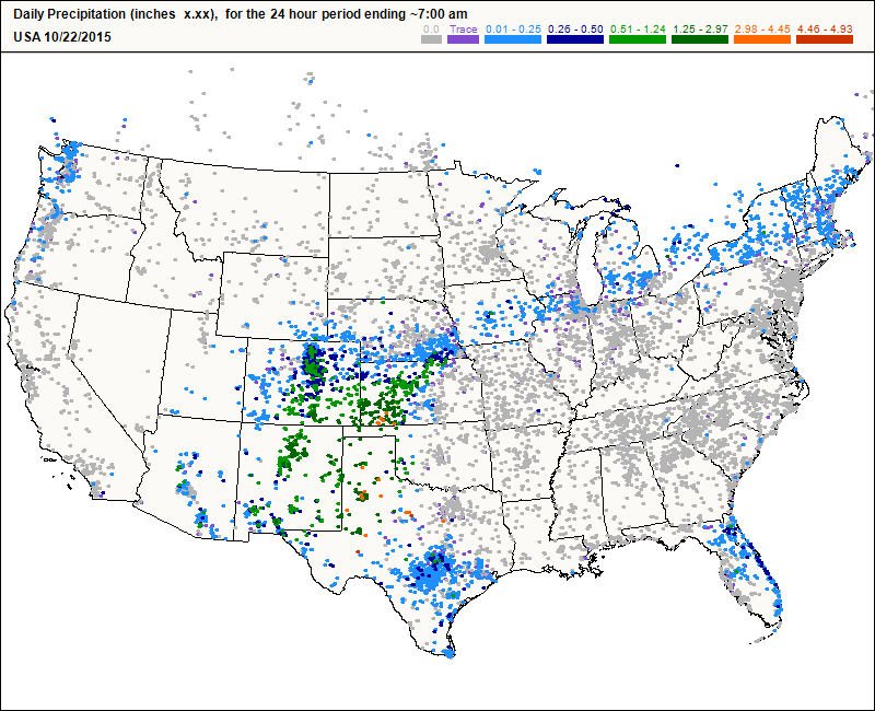
This heavy rain event was the first measurable rainfall in the month of October, which is normally one of our driest months. This event was also the first measurable rain since the flash flood event at the end of September 2015. The graphic below shows rainfall estimates across our county warning area (CWA).

A list of official storm total accumulations (72 hours) from selected sites across the area can be seen in the image below.

From social media - One of our storm spotters also reported a storm total of 8 inches in the Bellview community in Pensacola, FL. An off-duty NWS employee measured 6.86 inches in the west Mobile area. Another observer reported 7.35 inches in the west Mobile area near the Mobile Regional Airport.
Below is an animated graphic of CoCoRaHS precipitation reports from the CoCoRaHS blog showing the heavy rainfall reports across southeast Mississippi, southwest Alabama and northwest Florida during this event.
Coastal Flooding & Rough Surf
Coastal Flood Advisory was upgraded to a Coastal Flood Warning on the morning of the 26th. Tides were running 3-4 feet above predicted tidal levels during the day on the 26th with observed high tides occurring at night on the 26th. In addition to the Coastal Flood Warning, a High Surf Advisory and High Risk of Rip Currents were also in effect for the coastal counties.
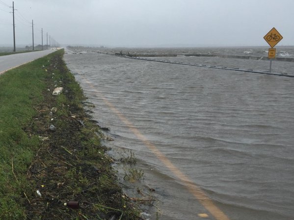
The eastbound lanes of the Causeway over Mobile Bay were shut down due to coastal flooding as well as numerous coastal roads and highways across coastal Alabama and northwest Florida. The road to Fort Pickens and roads on the west end of Dauphin Island also flooded. The picture below is a view of the eastbound lanes on the Causeway (courtesy of ALDOT).
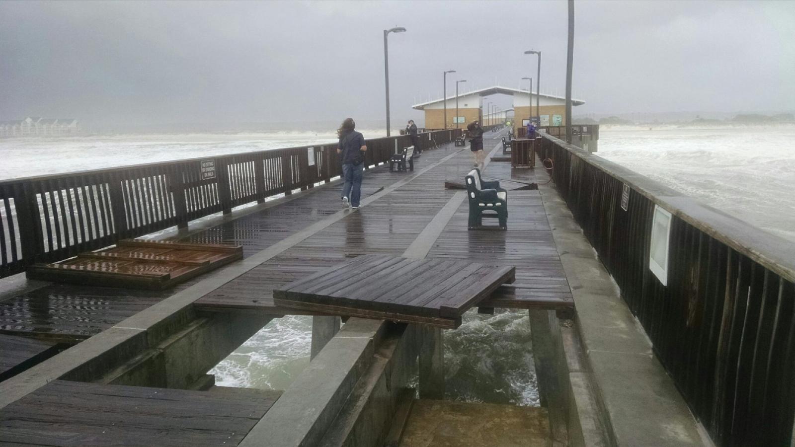
The floating restaurant on Crab Island (near Destin, FL) sank in the rough seas. Docks flooded on the Fish River, Dog River and in the Gulf Breeze area. The Pensacola Beach Pier and Navarre Beach Pier both closed due to high wind and rough surf. Notably, the Gulf State Park Pier sustained serious damage with multiple panels on the pier popping up and buckling due to the rough seas and surf. The lighting and waterlines were also damaged. Below are a few pictures of the damage to the Gulf State Park Pier (from the Gulf State Park Facebook page).


Wind Gusts
A Wind Advisory was issued for the entire area ahead of the main event. Winds peaked at 53 mph early in the morning before 4am on the 26th at the Mobile Regional Airport with similarly high peak winds observed across the entire area. School buses were not run on Dauphin Island during the day due to very strong winds on the Dauphin Island Bridge. Ferry service across southern Mobile Bay was halted due to a combination of strong winds and rough seas.
A list of storm peak winds (in mph) from selected sites across the area can be seen in the image below.

Wave Heights
NDBC Buoy 42012, located approximately 44 nautical miles southeast of Mobile or 12 nautical miles southeast of Dauphin Island, reported a significant wave height of 14.4 feet during the afternoon of October 26th.
Significant wave height simply means the average height of the highest 1/3 of waves. Individual waves may be more than twice the significant wave height.

More information and data from Buoy 42012 can be found on the NDBC webpage.
Acknowledgements: Page created by Morgan Barry (Forecaster) and Ryan Rogers (Forecaster).
LAST UPDATED: December 2017


 Follow us on YouTube