
April 27th, 2011
Tornado Outbreak Across The Deep South
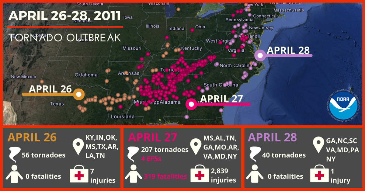
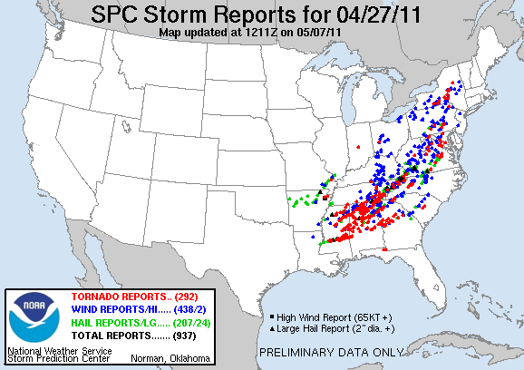
The 27 April 2011 Tornado Outbreak across the Deep South was part of another 3-day tornado outbreak (April 25-28), which was one of the largest, deadliest, and most destructive tornado outbreaks in US history. In total, there were 343 tornadoes over this 3-day period with 207 tornadoes on April 27 alone. 4 of the 207 tornadoes on April 27th were EF-5. There was only 1 tornado (out of the 207) that occurred across the NWS Mobile/Pensacola County Warning Area (CWA) on April 27th - an EF-3 that crossed into northwestern Choctaw County, AL. To view the staggering amount of tornado reports from the Deep South submitted to the Storm Prediction Center (SPC), head over to the SPC Severe Weather Archive.
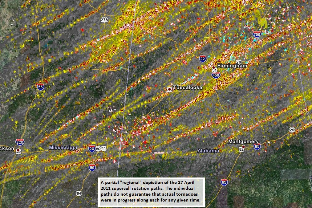
Although the majority of the NWS Mobile CWA was spared during this historic tornado outbreak, northern Choctaw County, AL certainly was not. A regional view of supercell rotation tracks (courtesy of the National Severe Storms Laboratory) on April 27th shows the extent of the outbreak and just how far south it extended (clipping the northern portion of our CWA).
Northern Choctaw County, AL EF-3 Tornado
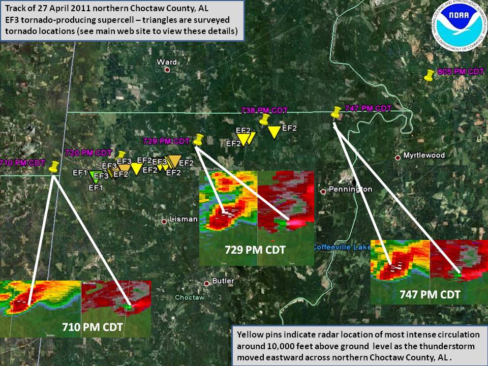 At approximately 710pm, a strong tornado moved from extreme northeastern Clarke County, MS (NWS Jackson CWA) into northern Choctaw County approximately 4 miles southwest of the town of Yantley. This tornado remained on the ground for the entire width of northern Choctaw County. The tornado crossed the Tombigbee River near the town of Oakchia in Choctaw County and then continued into NWS Birmingham's CWA at approximately 747pm.
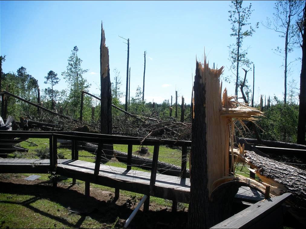
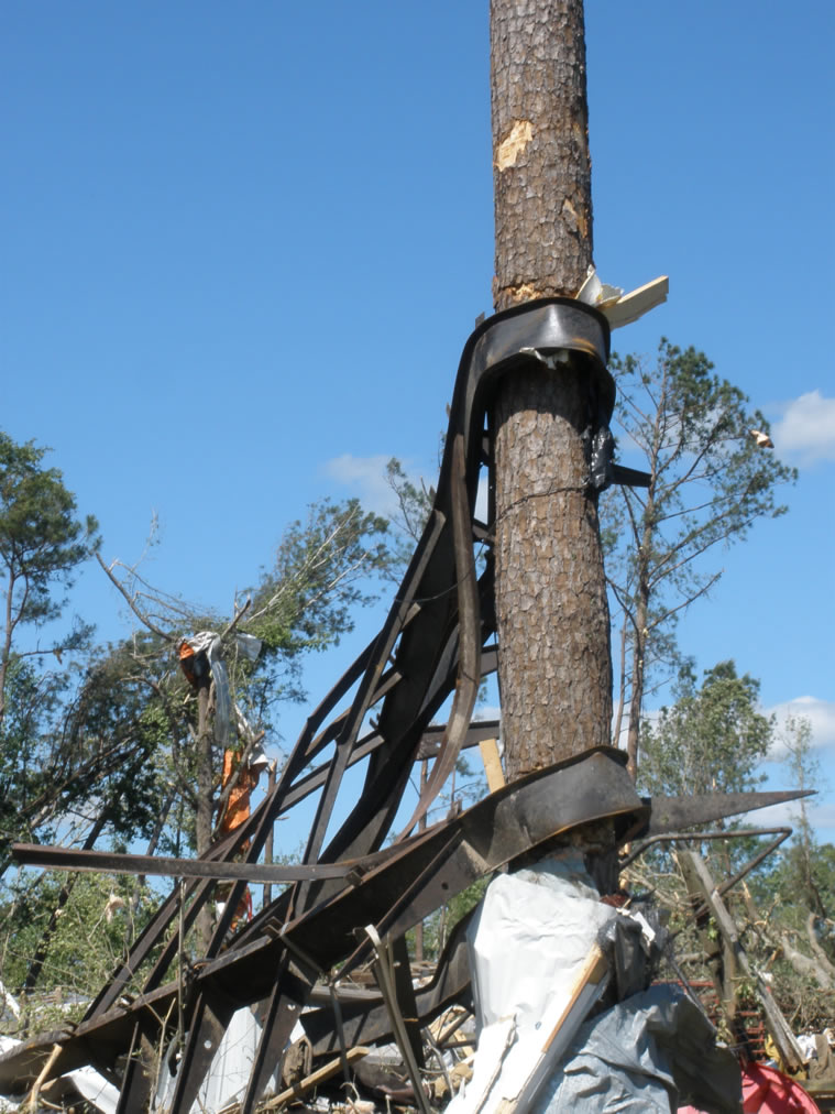
This tornado traveled nearly parallel to County Road 32 producing EF-2 damage with sporadic EF-3 damage along its path. There was considerable tree damage along the entire path with many trees snapped off above ground level and some trees completely uprooted. Extensive house and structure damage was noted along the path with EF-3 damage to one house where the roof was tossed, thus causing the exterior walls to collapse. Several mobile homes along the path were completely destroyed.
The image to the right shows the supercell rotation track (times noted alongside the pins), the surveyed damage locations (colored triangles), and select screenshots of the supercell’s reflectivity and velocity between 710pm and 747pm. [Note: Choctaw County, AL is far from all radar sites in the region, so the radar base reflectivity and velocity at the lowest cut are still around 10,000 feet above ground level.] The tornado’s track appears to be continuous along a 23.7 mile track with maximum winds of 150mph across the northern portion of Choctaw County, AL. [Note: this tornado spanned 3 different NWS CWA's - Jackson, Mobile, and Birmingham - so the total path length was much larger than denoted above.]
A few pictures of the EF-3 tornado damage across northern Choctaw County, AL are shown below. Click on the images for a larger view.


April 27, 2011 marks the deadliest tornado day since March 18, 1925 when 747 people were killed by tornadoes.
Public Information Statement
PUBLIC INFORMATION STATEMENT
NATIONAL WEATHER SERVICE MOBILE AL
948 PM CDT THU APR 28 2011
...NWS DAMAGE SURVEY TEAM FINDS EF-3 TORNADO TRACK ACROSS NORTHERN CHOCTAW COUNTY ALABAMA...
EVENT OCCURRED THE EVENING OF APRIL 27, 2011
* EVENT LOCATION: FROM 4 MI SW OF YANTLEY, AL TO NEAR OAKCHIA, AL
* STORM CLASSIFICATION: EF-3 INTENSITY TORNADO (MAX WINDS: 150 MPH)
* BEGINNING LAT/LON: 32.216N / -88.432W
* ENDING LAT/LON: 32.308N / -87.978W
* PATH LENGTH: 27.3 MILES
* MAXIMUM WIDTH: 1000 YARDS
* NOTES: THE NATIONAL WEATHER SERVICE SURVEY TEAM FOUND EVIDENCE
THAT THE TORNADO WAS ALREADY ON THE GROUND AS IT MOVED OUT OF
EXTREME NORTHEASTERN CLARKE COUNTY MISSISSIPPI INTO NORTHERN CHOCTAW
COUNTY APPROXIMATELY 4 MILES TO THE SOUTHWEST OF THE COMMUNITY OF
YANTLEY. THE TORNADO THEN REMAINED ON THE GROUND AS IT MOVED EAST
ACROSS THE ENTIRE WIDTH OF EXTREME NORTHERN CHOCTAW COUNTY...BEFORE
EXITING THE COUNTY BY CROSSING THE TOMBIGBEE RIVER NEAR THE
COMMUNITY OF OAKCHIA. THE TORNADO NEARLY PARALLELED COUNTY ROAD 32
AS IT MOVED EAST ACROSS THE COUNTY...PRODUCING EF-2 AND SPORADIC
EF-3 DAMAGE ALONG IT`S PATH. CONSIDERABLE TREE DAMAGE WAS NOTED
ALONG THE ENTIRE PATH...WITH MANY TREES SNAPPED OFF ABOVE GROUND
LEVEL AND SOME TREES COMPLETELY UP ROOTED. EXTENSIVE DAMAGE TO HOMES
AND OTHER STRUCTURES WAS ALSO NOTED...WITH EF-3 DAMAGE TO ONE HOME
THAT HAD IT`S ROOF TAKEN OFF AND EXTERIOR WALLS COLLAPSED. SEVERAL
MOBILE HOMES ALONG THE PATH OF THE TORNADO WERE ALSO COMPLETELY
DESTROYED.
NWS Local Write-Ups and Webpages:
NWS Birmingham
NWS Huntsville
NWS Jackson
NWS Nashville
NWS Paducah
NWS Louisville
NWS Morristown
NWS Atlanta
NWS Columbia
NWS Wakefield
Acknowledgements: Page created by Jeffrey Medlin (Meteorologist In Charge). Page updated by Morgan Barry (forecaster).
LAST UPDATED: May 2017

