Event Summary
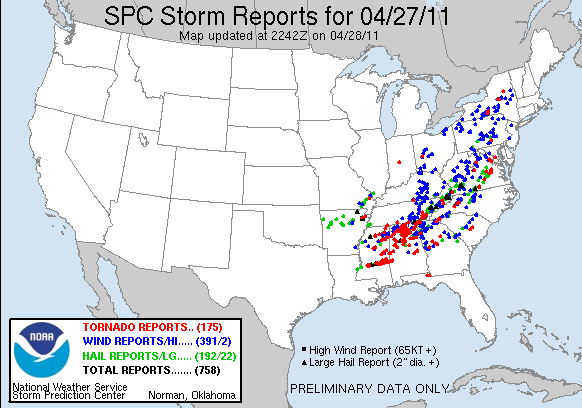
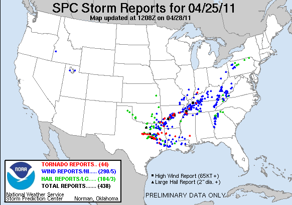
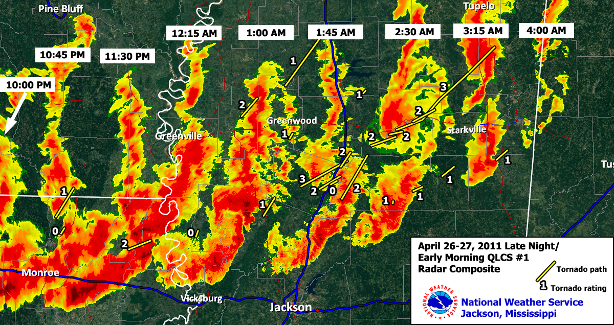
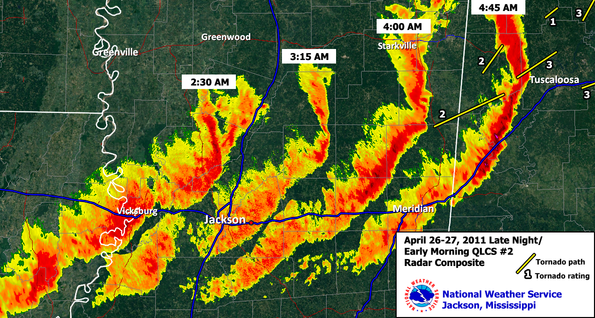
A historic outbreak of severe weather and tornadoes occurred on April 25-27 across the southern and southeast parts of the country. The first event started on Monday the 25th across northeast Texas and spread across the Mid-South and into portions of Louisiana. This event included multiple reports of large hail, damaging winds and tornadoes. The second event occurred from Tuesday afternoon into the early morning hours of April 26-27. This event initially started out as supercells producing large hail and tornadoes across northeast Texas and portions of Arkansas before evolving into a squall line. This line of storms had multiple stages of evolution and moved across several states before dissipating. This line was very efficient in producing wind damage as it pushed east. More impressively, this line produced many tornadoes and is responsible for 21 of the total tornadoes for this event. Of those 21, 11 were rated as strong (EF2, EF3) tornadoes and had fairly long path lengths.
The atmosphere reloaded quickly Wednesday morning and became increasingly favorable for more severe storms. The driving force for the 3rd event was a potent shortwave and deep surface low that intensified during the day Wednesday. The winds in the mid levels of the atmosphere increased to 80-100 mph and helped deepen the surface low further which in turn caused the low level winds to become stronger. The wind shear that was caused by the increasing winds aloft, and turning of the winds from south to westerly, was at rare levels for late April. Additionally, high low level moisture returned to the area in the wake of the morning complex and combined with morning sunshine to cause a very unstable airmass. The combination that resulted was an extremely rare mix of instability and wind shear. These ingredients, along with lift from a potent upper disturbance, ultimately led to the historic tornado outbreak of April 27, 2011.
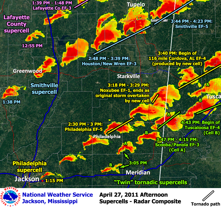
By midday and early afternoon, several discrete supercell thunderstorms were developing across the forecast area. It did not take long for these storms to take on “classic” supercell structures and begin producing tornadoes. The first tornado of the afternoon started in Neshoba County on the north side of Philadelphia. This tornado was rated EF5 and tracked for 29 miles into Noxubee County. From this point on, multiple tornadoes developed from multiple supercell storms. Nearly all of the storms produced tornadoes, with many of them long track and significant. The other violent tornado to impact the Jackson, MS forecast area occurred across Smith, Jasper, and Clarke Counties. This tornado continued into Alabama and had a total path length of 92.3 miles. At this point, 12 of the tornadoes were violent (EF4, EF5) with most of these having a path length greater than 70 miles.
Loss of life during this historic event was staggering. At this time, roughly 342 people lost their lives, with thousands more injured. This is now the second deadliest tornado outbreak in US history. The Mar 18, 1925 Tri-State tornado outbreak is first with 747 fatalities. This marks the first EF5 tornado in Mississippi since the Candlestick Park tornado on May 3, 1966. Additionally, this marks the first time since statistics have been kept that two EF5 tornadoes have been recorded on the same day in Mississippi, with the tornado in Smithville also rated as an EF5.
Regional Impacts
 |
 |
|
|
Survey Information- Click on the location in the table for additional maps and details
| Location | Start/ End Time |
Event Type | Fatalities/ Injuries |
Path Length | Path Width |
| Morehouse Parish/Ashley County 7 WSW Beekman LA to 7 SE Crossett AR |
4/26 10:45 pm- 11:02 pm |
EF-1 Tornado 110 mph |
13 miles | 1/4 mile | |
| Morehouse Parish 4 WSW Bastrop to 2 NW Bastrop |
4/26 10:44 pm- 10:46 pm |
EF-0 Tornado 80 mph |
2.5 miles | 75 yards | |
| West Carroll/East Carroll Parishes 5 S Pioneer to 6 SW Lake Providence |
4/27 12:03 am- 12:16 pm |
EF-2 Tornado 115 mph |
11.5 miles | 1/2 mile | |
| Sharkey County 2 SSW Cary to Cary |
4/27 12:35 am- 12:37 am |
EF-0 Tornado 75 mph |
2 miles | 100 yards | |
| Sunflower County 3 W Sunflower to 2 ENE Doddsville |
4/27 12:43 am- 12:56 am |
EF-2 Tornado 125 mph |
3 injuries | 11 miles | 1/4 mile |
| Yazoo/Holmes Counties 2 N Yazoo City to 2 NNE Eden |
4/27 1:12 am- 1:25 am |
EF-1 Tornado 100 mph |
10 miles | 250 yards | |
| Tallahatchie/Leflore counties 2 W Phillip to 4 SW Enid |
4/27 1:15 am- 1:46 am |
EF-1 Tornado 90 mph |
27.7 miles | 50 yards | |
| Leflore County Sidon to 3 NE Sidon |
4/27 1:24 am- 1:27 am |
EF-1 Tornado 90 mph |
3 miles | 100 yards | |
| Holmes/Carroll Counties Tornado #1 2 SW Lexington to 5 S Vaiden |
4/27 1:40 am- 2:05 am |
EF-3 Tornado 140 mph |
23 miles | 1 mile | |
| Holmes County Tornado #1 5 ESE Lexington to 2.5 SW West |
4/27 1:40 am- 1:50 am |
EF-2 Tornado 130 mph |
9 miles | 1 mile | |
| Attala/Montgomery Counties 2 SW Sallis to 9.5 NE Hesterville |
4/27 1:49 am- 2:10 am |
EF-2 Tornado 125 mph |
23 miles | 4/10 mile | |
| Holmes County Tornado #2 2 N Durant to 4 N Durant |
4/27 1:51 am- 1:52 am |
EF-0 Tornado 85 mph |
1.8 miles | 50 yards | |
| Holmes/Carroll Counties Tornado #2 2.5 NW West to 2.5 ESE Vaiden |
4/27 1:59 am- 2:12 am |
EF-2 Tornado 115 mph |
9.5 miles | 1/2 mile | |
| Grenada County 3.5 miles S Gore Springs to 2.5 SSE Gore Springs |
4/27 2:06 am- 2:08 am |
EF-1 Tornado 105 mph |
1.5 miles | 150 yards | |
| Montgomery/Choctaw Counties 1.75 W Poplar Creek to 10 ENE Poplar Creek |
4/27 2:17 am- 2:28 am |
EF-2 Tornado 115 mph |
11.5 miles | 1 mile | |
| Attala County 2.5 NNW Zama to 3.0 N Zama |
4/27 2:18 am- 2:20 am |
EF-1 Tornado 95 mph |
1 mile | 50 yards | |
| Choctaw County 9 ESE Kilmichael to 7 ESE Stewart |
4/27 2:25 am- 2:33 am |
EF-2 Tornado 120 mph |
2 injuries | 7 miles | 1 mile |
| Choctaw/Webster/Clay/Chickasaw/Monroe Counties 9 SW Eupora to 6 W Amory |
4/27 2:29 am- 3:26 am |
EF-3 Tornado 140 mph |
25 injuries | 58.7 miles | 1 mile |
| Winston County Tornado #1 11 WSW Louisville to 7 WSW Louisville |
4/27 2:29 am- 2:34 am |
EF-1 Tornado 95 mph |
4 miles | 150 yards | |
| Webster/Choctaw Counties 2.5 S Eupora to 5.5 N Maben |
4/27 2:37 am- 2:49 am |
EF-2 Tornado 125 mph |
1 fatality | 14.5 miles | 3/4 mile |
| Winston County Tornado #2 3 NE Louisville to 1 NE Betheden |
4/27 2:47 am- 2:57 am |
EF-1 Tornado 110 mph |
8 miles | 200 yards | |
| Noxubee/Lowndes Counties 1.25 NW Brooksville to 6.5 NE Brooksville |
4/27 3:18 am- 3:25 am |
EF-1 Tornado 95 mph |
6.25 miles | 150 yards | |
| Kemper MS/Noxubee MS/Pickens AL counties 6.9 NNW Scooba MS to 10 E Aliceville AL |
4/27 4:03 am- 4:35 am |
EF-2 Tornado 125 mph |
35.2 miles | 8/10 mile | |
| Neshoba/Kemper/Winston/Noxubee Counties 1 N Philadelphia to 6 SE Mashulaville |
4/27 2:30 pm- 3:00 pm |
EF-5 Tornado 205 mph |
3 fatalities/6 injuries | 29 miles | 1/2 mile |
| Webster/Calhoun/Chickasaw/Monroe counties 3.5 miles N Bellefontaine to 1 E Bigbee |
4/27 2:48 pm- 3:38 pm |
EF-3 Tornado 150 mph |
4 fatalities/25 injuries | 51.3 miles | 3/4 mile |
| Copiah/Hinds Counties 5 miles NW Crystal Springs to 2 SSW Terry |
4/27 3:11 pm- 3:24 pm |
EF-2 Tornado 115 mph |
2 injuries | 7 miles | 1/4 mile |
| Noxubee County 3.6 NE Macon to 4.5 W Bigbee Valley |
4/27 3:18 pm- 3:29 pm |
EF-1 Tornado 110 mph |
9 miles | 500 yards | |
| Kemper MS/Sumter AL/Pickens AL Counties 1.9 NE Scooba MS to 5 SSE Aliceville AL |
4/27 3:47 pm- 4:15 pm |
EF-3 Tornado 140 mph |
2 injuries | 23.7 miles | 1/2 mile |
| Smith County 3.6 miles S Polkville to 2.6 N Burns |
4/27 4:27 pm- 4:38 pm |
EF-3 Tornado 130 mph |
8.2 miles | 1/4 mile | |
| Newton County 2 S Newton to 2 N Hickory |
4/27 5:08 pm- 5:22 pm |
EF-3 Tornado 145 mph |
11 miles | 1/4 mile | |
| Smith/Jasper/Clarke/Choctaw AL/Sumber AL/Marengo AL/Perry AL counties 1 mile ESE Raleigh to 3 NNE Uniontown |
4/27 5:42 pm- 8:35 pm |
EF-4 Tornado 175 mph |
7 deaths/17 injuries | 122 miles | 6/10 mile |
| Lauderdale County 7.5 NW Meridian to 9 N Meridian |
4/27 5:45 pm- 5:59 pm |
EF-0 Tornado 80 mph |
12 miles | 100 yards |
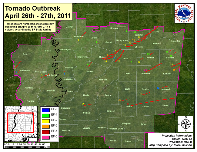
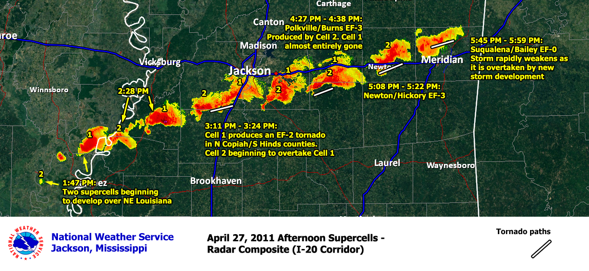
Radar and Tornado Tracks
Overnight tornadoes
Afternoon tornadoes

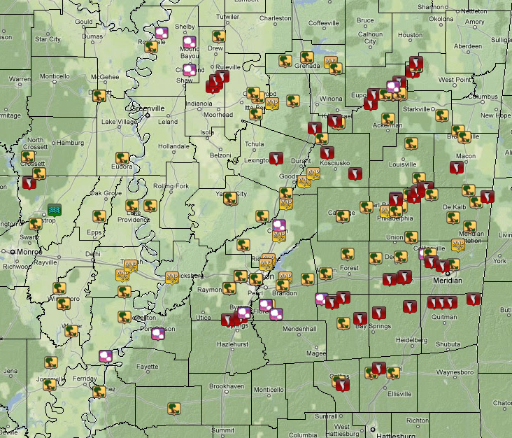
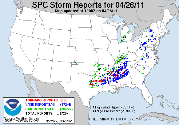
Local Storm Reports