
A strong atmospheric river will continue moderate to heavy rainfall with possible flooding, gusty to high winds, and mountain snows for parts of the Northwest U.S. into Thursday. Additional impacts are likely into Friday with a cold front. A fast-moving storm system will cross the Northeast U.S. Wednesday into Thursday with gusty to high winds and areas of rain and high elevation snow showers. Read More >
Grade Summary
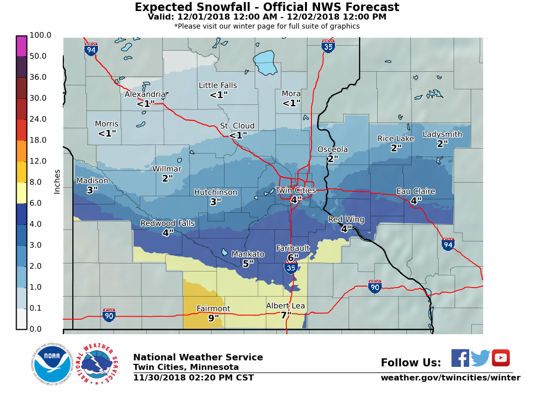
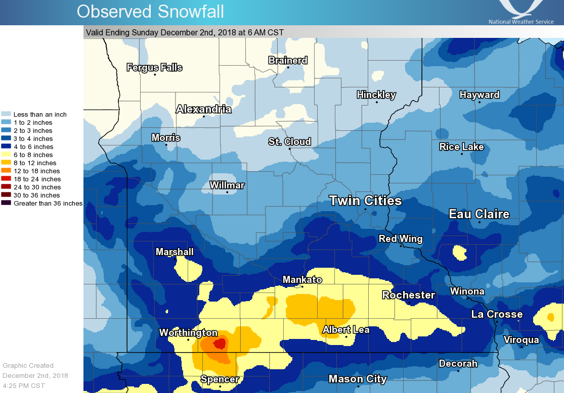
A large, strong low pressure system tracked from the central Plains to southern Iowa from November 30-December 1. It weakened as it pushed east, which resulted in a gradual weakening of the snow shield from the evening of December 1 into the morning of December 2. The initial band of snow that swung north from the system was the most intense, with visibility dropping to 1/8 of a mile for a time during the late afternoon at Minneapolis/St. Paul airport. Snow rates of 1 to 2 inches per hour accompanied the narrow band. The band lifted north and diminished as it reached the St. Cloud area. A break followed the first band, but redevelopment occurred by evening across southern Minnesota. The snow shield reached as far north as Redwood Falls, the Twin Cities, and New Richmond, WI but little fell north of there for the rest of the event. The snow very slowly diminished during the overnight hours into the morning of December 2nd.
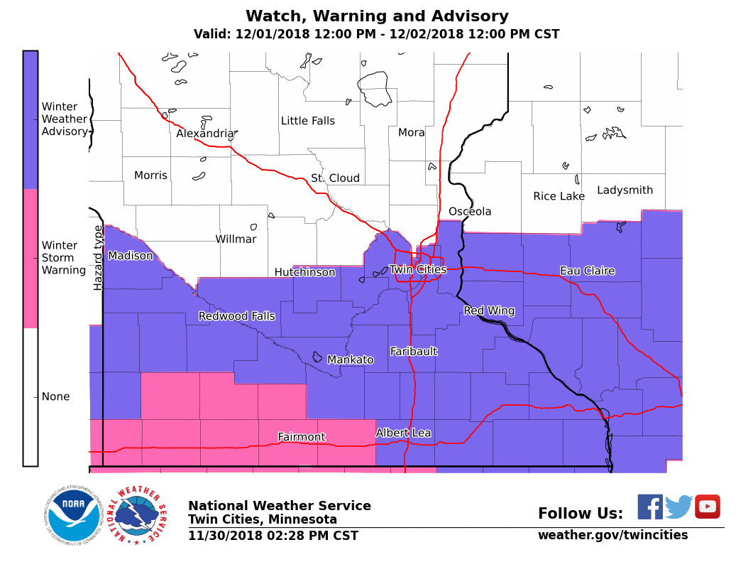
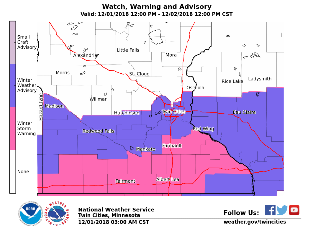
The initial Winter Storm Watch was issued on the morning of November 29th across southern Minnesota. The watch was upgraded to a Winter Storm Warning for Watonwan, Martin, and Faribault counties on the afternoon of November 30th, which was expanded eastward across much of the rest of southern Minnesota during the morning of December 1.
Local conditions and perceptions may vary from the objective grade calculated below. Step through the other tabs to see a breakdown of the scoring.
|
91% |
Graded Element | Possible Points | Actual Points |
| 6 inch contour error | 8 | 8 | |
| Magnitude of snow error | 8 | 8 | |
| Onset timing error | 4 | 3 | |
| Peak wind gust error | 4 | 4 | |
| Probability of Detection/False Alarm Ratio | 8 | 7 | |
| Warning lead time | 8 | 6 | |
| Impact messaging | 4 | 4 | |
| Total | 44 | 40 | |
| Grade | 91% |
6 inch contour error
 |
 |
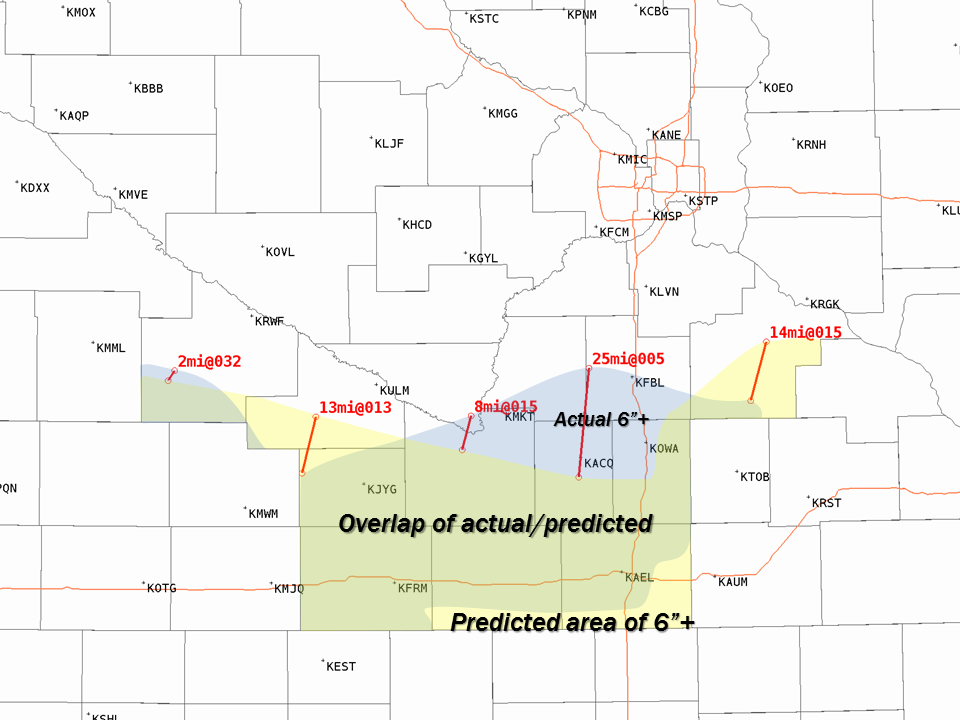 |
| Official snowfall forecast at initial warning issuance | Observed Snowfall | Overlap of predicted and observed 6 inch snowfall areas |
| Error | Points |
| <=15 miles | 8 |
| 16-20 miles | 7 |
| 21-25 miles | 6 |
| 26-30 miles | 5 |
| 31-35 miles | 4 |
| 36-40 miles | 3 |
| 41-45 miles | 2 |
| 46-50 miles | 1 |
| 51+ miles | 0 |
| Actual: 12.4 miles | 8 |
Magnitude of snow error
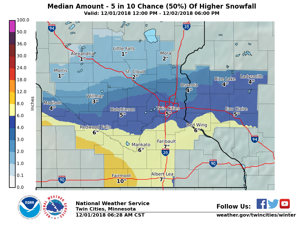
The highest amount of snow forecast was 10 inches in Martin county. The highest total was 12.0 inches in St. James, MN, making for a top snow report error of 2.0 inches.
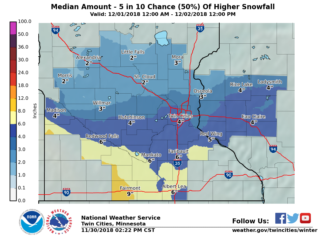
Forecast with initial warning issuance
Friday afternoon, November 30, 2018:
|
 |
 |
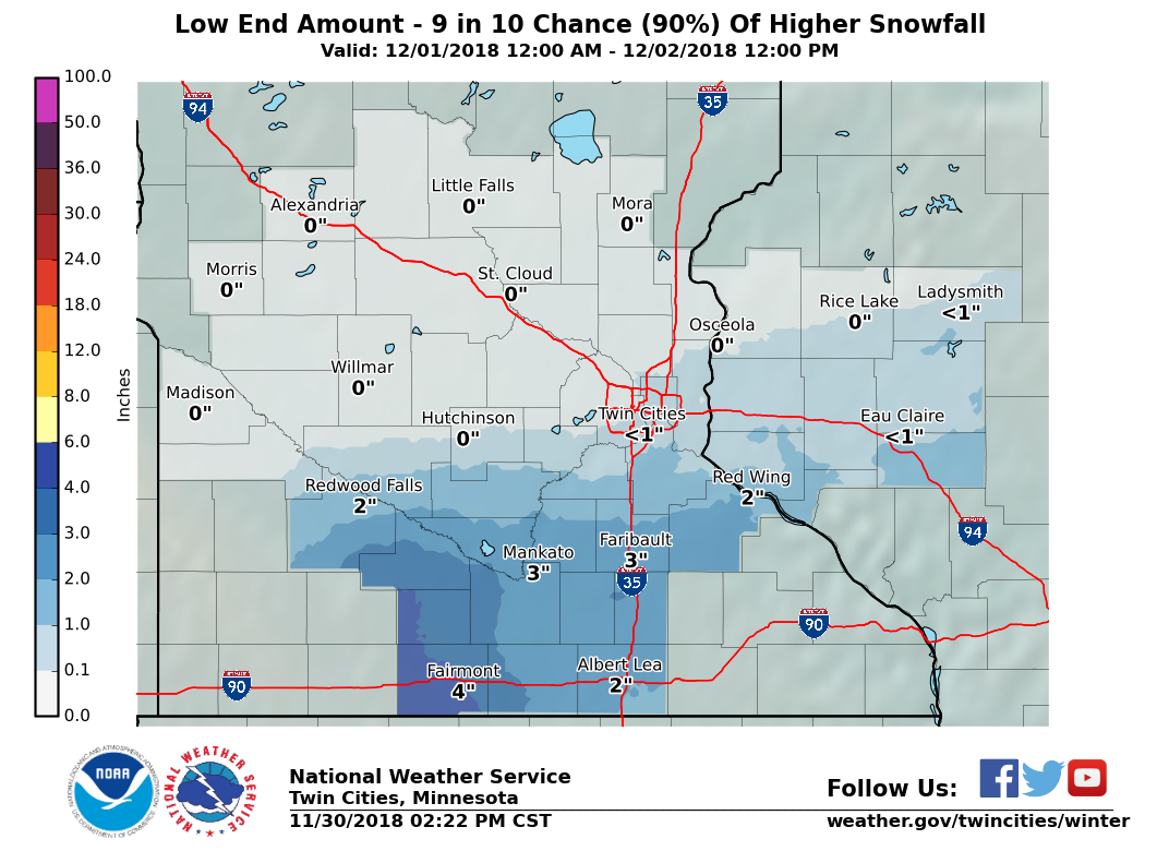
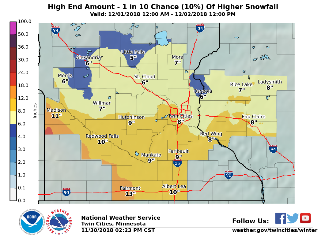 |
| Official snowfall forecast | Low end amount (90% chance for more snow than this) | Median amount (equal chances for more or less than this) | High end amount (10% chance for more snow than this) |
| Error | Points |
| <=2" | 8 |
| 2.1-3.5" | 6 |
| 3.6-5.0" | 4 |
| 5.1-6.5" | 2 |
| 6.6+" | 0 |
| Actual: 2.0" | 8 |
Subsequent Forecasts
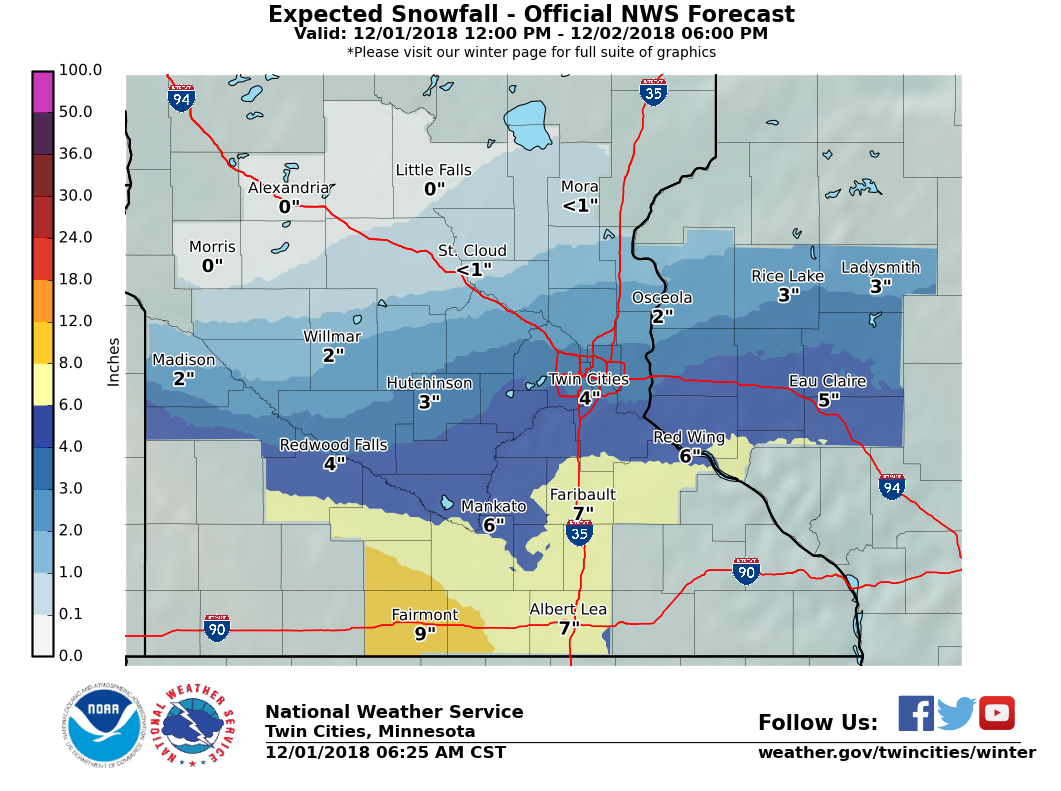
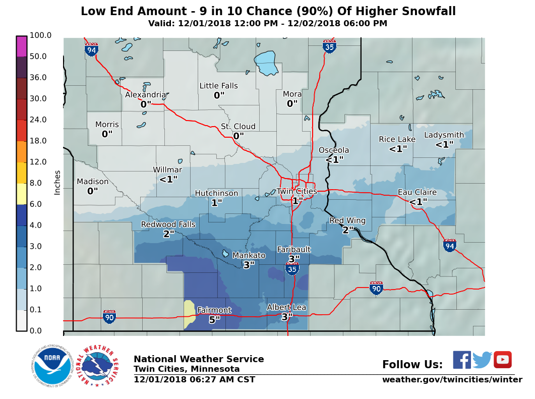
Saturday morning, December 1, 2018:
 |
 |
 |
 |
| Official snowfall forecast | Low end amount (90% chance for more snow than this) | Median amount (equal chances for more or less than this) | High end amount (10% chance for more snow than this) |
Snowfall reports by county:
Location                     Amount    Time/Date       Provider

...Minnesota...

...Anoka County...
Blaine                       3.3 in    1030 PM 12/01
Ramsey 3NE                   2.5 in    0700 AM 12/02   COCORAHS
Coon Rapids                  2.1 in    0838 AM 12/02
2 NNE Ramsey                 1.6 in    0830 AM 12/02   COCORAHS
Anoka 1SE                    1.5 in    0700 AM 12/02   COCORAHS
Blaine 2NNW                  1.2 in    0600 AM 12/02   COCORAHS
East Bethel 4ENE             1.0 in    0315 AM 12/02   COCORAHS

...Benton County...
Rice                          T in     0700 AM 12/02   COOP

...Blue Earth County...
Lake Crystal                 8.5 in    0655 AM 12/02
Mankato 1ESE                 8.3 in    0700 AM 12/02   COCORAHS
Amboy                        8.0 in    1030 AM 12/02
Mankato                      8.0 in    0620 AM 12/02

...Brown County...
Springfield 1NW              6.0 in    0700 AM 12/02   COCORAHS
Sveadahl 5NNW                4.1 in    0700 AM 12/02   COCORAHS
New Ulm                      4.0 in    1030 PM 12/01
Sleepy Eye                   4.0 in    0800 AM 12/02   COCORAHS
New Ulm                      3.0 in    0500 AM 12/02   COCORAHS

...Carver County...
Chanhassen (NWS)             5.3 in    0600 AM 12/02   OFFICIAL NWS OB
Carver 1W                    4.6 in    0700 AM 12/02   COCORAHS
Victoria                     4.5 in    1039 AM 12/02
Victoria 1WSW                4.0 in    0700 AM 12/02   COCORAHS
Chaska                       3.8 in    0641 AM 12/02   COCORAHS
Victoria 2ENE                3.5 in    0800 AM 12/02   COCORAHS
Waconia                      3.2 in    0600 AM 12/02   UCOOP
1 NNW Watertown              2.5 in    0500 AM 12/02

...Chippewa County...
Milan 1NW                    2.5 in    0600 PM 12/02   COOP
Maynard                      2.0 in    0728 PM 12/02
Montevideo                   1.5 in    0700 AM 12/02   COCORAHS
Clara City                   1.0 in    0320 PM 12/02

...Chisago County...
Chisago City 2ENE            1.8 in    0700 AM 12/02   COCORAHS
North Branch 1NNW            1.7 in    0600 AM 12/02   COCORAHS
Stacy 1W                     1.5 in    0700 AM 12/02   COCORAHS
Wild River                   1.5 in    0800 AM 12/02   COOP
Harris 5WNW                  1.2 in    0800 AM 12/02   COCORAHS

...Dakota County...
Northfield 2NE               4.7 in    0730 AM 12/02   COCORAHS
Hastings 1W                  4.6 in    0700 AM 12/02   COCORAHS
Burnsville                   4.5 in    1030 PM 12/01
Hastings (L/D 2)             4.0 in    0600 AM 12/02   COOP
2 NE Northfield              4.0 in    0238 PM 12/02
Rosemount 3WNW               4.0 in    0700 AM 12/02   COCORAHS
1 SW Rosemount               3.8 in    1033 PM 12/01
1 W Hastings                 3.7 in    0700 AM 12/02   COCORAHS
Apple Valley 3ESE            3.5 in    0700 AM 12/02   COCORAHS
2 SW Eagan                   3.5 in    1030 PM 12/01
Lakeville 2WSW               3.5 in    0810 AM 12/02   COCORAHS
Mendota Heights              3.5 in    1030 PM 12/01
Apple Valley 3SSE            3.0 in    0720 AM 12/02   COCORAHS

...Faribault County...
Winnebago                    9.0 in    0911 AM 12/02
Blue Earth                   8.0 in    0700 AM 12/02   COCORAHS

...Freeborn County...
1 WSW Albert Lea             8.1 in    0700 AM 12/02
Albert Lea 1WSW              8.0 in    0700 AM 12/02   COCORAHS
Albert Lea                   7.8 in    0838 AM 12/02
8 NE Myrtle                  4.0 in    0741 AM 12/02

...Goodhue County...
4 SSE Kenyon                 8.0 in    0359 PM 12/02
Nerstrand 4E                 4.3 in    0700 AM 12/02   COCORAHS
Cannon Falls                 4.0 in    0800 AM 12/02   COCORAHS
Zumbrota                     4.0 in    0620 AM 12/02   COCORAHS
Vasa 3ENE                    3.2 in    0700 AM 12/02   COCORAHS
Red Wing                     3.0 in    0737 AM 12/02
Vasa 5NNE                    1.9 in    0700 AM 12/02   COCORAHS
5 NW Red Wing                1.7 in    0600 AM 12/02

...Hennepin County...
Long Lake 4SW                3.5 in    0700 AM 12/02   COCORAHS
Minneapolis 2 ESE            3.2 in    0900 AM 12/02   COCORAHS
Long Lake                    3.0 in    0900 AM 12/02   COCORAHS
2 WNW Richfield              3.0 in    0400 AM 12/02
St. Louis Park 2ESE          3.0 in    0615 AM 12/02   COCORAHS
Edina 1SE                    2.8 in    0750 AM 12/02   COCORAHS
MSP Airport                  2.8 in    1200 PM 12/02   OFFICIAL NWS OB
3 S Minnetonka               2.8 in    1036 AM 12/02
St. Bonifacius 2ENE          2.8 in    0700 AM 12/02   COCORAHS
Edina 1SW                    2.7 in    0700 AM 12/02   COCORAHS
Edina 2 ENE                  2.7 in    0900 AM 12/02   COCORAHS
Richfield 2NNW               2.7 in    0700 AM 12/02   COCORAHS
2 N Golden Valley            2.6 in    0515 AM 12/02
Bloomington 1 ESE            2.5 in    0700 AM 12/02   COCORAHS
Eden Prairie 3SE             2.3 in    0947 AM 12/02   COCORAHS
2 WSW Long Lake              2.3 in    0745 AM 12/02   COCORAHS
3 E Richfield                2.3 in    1200 AM 12/02
Minneapolis Dwtn             2.3 in    0600 AM 12/02   COOP
2 NE Corcoran                2.0 in    0800 AM 12/02   COCORAHS
Edina                        2.0 in    1030 PM 12/01
1 NE Maple Grove             2.0 in    0730 AM 12/02   COCORAHS
Brooklyn Park 2E             1.9 in    0700 AM 12/02   COCORAHS
Plymouth 2ENE                1.8 in    0700 AM 12/02   COCORAHS
Robbinsdale                  1.8 in    0700 AM 12/02   COCORAHS
Brooklyn Center 1E           1.7 in    0700 AM 12/02   COCORAHS
Osseo 1W                     1.6 in    0700 AM 12/02   COCORAHS
Champlin 1SW                 1.5 in    0700 AM 12/02   COCORAHS
Maple Grove 1N               1.4 in    1115 AM 12/02   COCORAHS
Osseo 1 NW                   1.0 in    0800 AM 12/02   COCORAHS

...Kandiyohi County...
New London                   2.0 in    0247 PM 12/02
4 SE Spicer                  1.5 in    0338 PM 12/02
4 S Regal                    1.0 in    0216 PM 12/02
Willmar                      1.0 in    0635 PM 12/02
Willmar 5N                   1.0 in    0600 AM 12/02   COOP
Spicer 3WSW                  0.5 in    0700 AM 12/02   COCORAHS

...Lac qui Parle County...
Dawson                       3.0 in    0700 AM 12/02   COOP

...Le Sueur County...
Waterville                   8.1 in    0842 AM 12/02
4 SSW Kasota                 8.0 in    1020 AM 12/02
2 S New Prague               6.0 in    0100 PM 12/02
Le Center                    5.6 in    0750 AM 12/02   COCORAHS
New Prague                   5.0 in    0700 AM 12/02   COCORAHS
Le Center 5NNW               4.0 in    0800 AM 12/02   COCORAHS

...Martin County...
Sherburn                     11.0 in   0935 AM 12/02
Fairmont                     7.5 in    0258 PM 12/02

...McLeod County...
Glencoe                      3.0 in    0629 PM 12/02
3 W Hutchinson               3.0 in    0320 PM 12/02
Lester Prairie               3.0 in    0723 PM 12/02
Glencoe 3NW                  2.0 in    0700 AM 12/02   COCORAHS
Hutchinson                   2.0 in    0700 AM 12/02   COCORAHS
Hutchinson 5N                2.0 in    0700 AM 12/02   COCORAHS
Hutchinson 1NNE              1.5 in    0700 AM 12/02   COCORAHS
Silver Lake 1NNW             1.2 in    0700 AM 12/02   COCORAHS

...Meeker County...
5 ENE Cedar Mills            2.8 in    0728 PM 12/02
Litchfield                   2.0 in    0316 PM 12/02
Dassel                       1.7 in    0700 AM 12/02   COCORAHS
Watkins 3WSW                 1.1 in    0900 AM 12/02   COCORAHS

...Morrison County...
Camp Ripley 4E               0.1 in    0800 AM 12/02   COCORAHS
Little Falls                  T in     0700 AM 12/02   COCORAHS

...Nicollet County...
1 WNW North Mankato          7.3 in    1105 PM 12/01
3 ESE New Ulm                4.7 in    0545 AM 12/02
St. Peter 6WSW               4.0 in    0700 AM 12/02   COCORAHS

...Ramsey County...
1 NNW North St. Paul         2.5 in    0800 AM 12/02
North St. Paul 1NNW          2.5 in    0700 AM 12/02   COCORAHS
Roseville 1NW                2.2 in    0700 AM 12/02   COCORAHS
North St. Paul               2.1 in    1030 PM 12/01
Vadnais Lake                 2.0 in    0200 PM 12/02   COOP
Roseville 2WNW               1.5 in    0600 AM 12/02   COCORAHS

...Redwood County...
1 NNE Redwood Falls          3.0 in    0648 PM 12/02

...Renville County...
Sacred Heart                 2.8 in    0156 PM 12/02
1 NNW Morton                 2.5 in    0220 PM 12/02
5 NE Bird Island             2.0 in    0340 PM 12/02
Bird Island 7SSE             1.7 in    0700 AM 12/02   COOP
Bird Island                  1.5 in    0650 AM 12/02   COCORAHS
Danube 2WNW                  1.5 in    0700 AM 12/02   COCORAHS
Olivia                       1.5 in    0416 PM 12/02

...Rice County...
1 WNW Faribault              7.8 in    1122 AM 12/02
1 ENE Faribault              7.5 in    0323 PM 12/02
1 ESE Faribault              6.8 in    1200 AM 12/02
1 ESE Northfield             5.5 in    0959 AM 12/02
Montgomery 3ENE              4.5 in    0600 AM 12/02   COCORAHS
Northfield                   4.3 in    1030 PM 12/01
1 WNW Veseli                 3.5 in    0500 AM 12/02

...Scott County...
Jordan 1SW                   4.6 in    0530 AM 12/02   COOP
2 W Prior Lake               4.5 in    0659 AM 12/02
Prior Lake 1WSW              4.5 in    0600 AM 12/02   COCORAHS
Prior Lake                   4.0 in    1030 PM 12/01
Shakopee                     3.7 in    0958 AM 12/02   COCORAHS

...Sherburne County...
Dayton                       2.0 in    0253 PM 12/02
2 WNW Zimmerman              2.0 in    0223 PM 12/02
4 N Becker                   1.0 in    0926 AM 12/02
Orrock 2SE                   1.0 in    0700 AM 12/02   COCORAHS
St. Cloud Airport            0.9 in    1200 AM 12/02   OFFICIAL NWS OB

...Sibley County...
Green Isle 1WNW              4.0 in    0700 AM 12/02   COCORAHS
Winthrop                     4.0 in    0641 AM 12/02
1 N New Auburn               3.0 in    0726 PM 12/02

...Stearns County...
3 N Kimball                  2.0 in    0600 AM 12/02
Cold Spring                  1.3 in    0700 AM 12/02   COCORAHS
Paynesville                  1.0 in    0651 PM 12/02
Paynesville 1SSW             1.0 in    0700 AM 12/02   COCORAHS
1 SSW Sauk Rapids            0.5 in    0731 AM 12/02   COCORAHS
St. Joseph                   0.5 in    0700 AM 12/02   COCORAHS
2 NNE St. Joseph             0.5 in    0700 AM 12/02   COCORAHS
St. Cloud (SCSU)             0.4 in    0600 AM 12/02   UCOOP
Albany 3SSE                  0.3 in    0700 AM 12/02   COCORAHS

...Steele County...
Owatonna                     8.5 in    1042 AM 12/02
Ellendale                    6.2 in    0700 AM 12/02   COCORAHS

...Waseca County...
Waseca 1NNE                  7.1 in    0700 AM 12/02   COCORAHS
Waseca                       5.5 in    1000 PM 12/01

...Washington County...
Woodbury                     4.0 in    0700 AM 12/02   COCORAHS
Lakeland 2WNW                3.0 in    0700 AM 12/02   COCORAHS
St. Paul Park                2.7 in    0700 AM 12/02   COCORAHS
Afton 1E                     2.0 in    0830 AM 12/02   COCORAHS
Mahtomedi                    1.8 in    0630 AM 12/02   COCORAHS
3 N Birchwood Village        1.6 in    0800 AM 12/02   COCORAHS
Stillwater 1NE               1.5 in    0755 AM 12/02   COCORAHS
Stillwater 2 SW              1.2 in    0800 AM 12/02   COOP

...Watonwan County...
St. James                    12.0 in   0342 PM 12/02
Madelia                      10.2 in   0914 AM 12/02

...Wright County...
Cokato                       2.0 in    0256 PM 12/02
St. Michael 1E               2.0 in    0800 AM 12/02   COCORAHS
Hanover 1WNW                 1.9 in    0700 AM 12/02   COCORAHS
Clearwater 4SSE              1.5 in    0800 AM 12/02   COCORAHS
St. Michael 2ENE             1.4 in    0630 AM 12/02   COCORAHS
Monticello 4WNW              1.0 in    0800 AM 12/02   COCORAHS
Rockford                     1.0 in    0700 AM 12/02   COOP

...Yellow Medicine County...
2 NW Wood Lake               2.0 in    0326 PM 12/02

...Wisconsin...

...Barron County...
Chetek 2SE                   3.0 in    0700 AM 12/02   COCORAHS
Cumberland                   1.0 in    0700 AM 12/02   COOP

...Chippewa County...
1 ESE Chippewa Falls         3.3 in    0700 AM 12/03   COCORAHS
Eau Claire AP                3.7 in    0600 PM 12/02   OFFICIAL NWS OB
Jim Falls 3NW                2.2 in    0630 AM 12/02   COOP
Bloomer                      2.0 in    0800 AM 12/02   COOP
Chippewa Falls               1.7 in    0800 AM 12/02   COOP
4 W Cornell                  1.5 in    1025 AM 12/02
Cornell 4W                   1.5 in    0800 AM 12/02   COCORAHS

...Dunn County...
Elk Mound                    3.5 in    0700 AM 12/02   UCOOP
Boyceville 3NNE              2.5 in    0700 AM 12/02   COCORAHS
Menomonie 1N                 2.5 in    0700 AM 12/02   COCORAHS
Elk Mound 1ENE               2.4 in    0700 AM 12/02   COCORAHS

...Eau Claire County...
Altoona                      3.4 in    0800 AM 12/03   COCORAHS
Eau Claire 3SW               2.2 in    1200 AM 12/02   COOP
3 SSW Altoona                2.0 in    1200 AM 12/02

...Pepin County...
3 NE Stockholm               4.5 in    0900 PM 12/01
Stockholm 2NE                4.5 in    0800 AM 12/02   COCORAHS

...Pierce County...
River Falls                  5.5 in    0913 PM 12/01
2 WSW Ellsworth              4.0 in    0700 AM 12/02   COCORAHS

...Polk County...
5 SSW Nye                    2.8 in    0858 AM 12/02
St. Croix Falls              2.0 in    0700 AM 12/02   COCORAHS
Luck                         1.5 in    0855 AM 12/02   COOP

...Rusk County...
Ladysmith 2WNW               1.7 in    0700 AM 12/03   COCORAHS

...St. Croix County...
1 SE Hudson                  5.6 in    1015 PM 12/01
2 W Roberts                  4.8 in    0201 PM 12/02
Baldwin                      4.0 in    0730 AM 12/02   COOP
Star Prairie                 2.3 in    1030 PM 12/01
Deer Park 2SE                2.0 in    0700 AM 12/02   COCORAHS

Observations are collected from a variety of sources with varying
equipment and exposures. We thank all volunteer weather observers
for their dedication. Not all data listed are considered official.
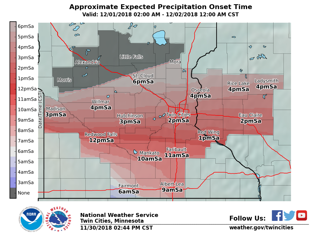
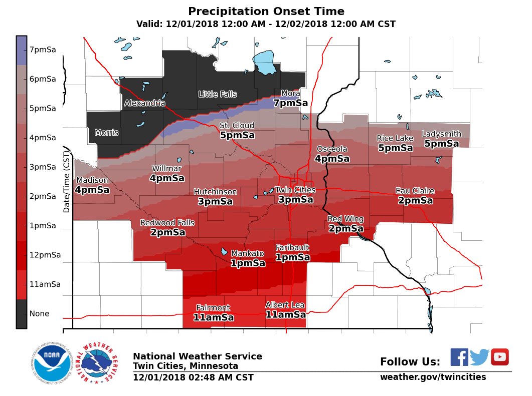
Onset timing error
The time visibility falls to less than 3 miles due to snow is noted for each warned weather station at an airport. This is considered the time accumulations and impacts begin. It is checked against the time snow becomes likely in the forecast when the initial warning is issued and the difference is calculated.
The onset timing was too quick with the initial warning issuance. Because the majority of counties were added to the warning after this trend became clear, the error was mitigated.
Forecast with initial warning issuance
Friday afternoon, November 30, 2018:
 |
 |
| Onset timing for initial warning | Watches, warnings, and advisories in effect |
| Warned Airport Weather Station | Expected time accumulating snow becomes likely | Actual time visibility fell to less than 3 miles due to snow | Error (hh:mm) |
| Fairmont (FRM) | 6:00 am | 11:46 am | 5:46 |
| St. James (JYG) | 8:00 am | 12:35 pm | 4:35 |
Subsequent Forecasts
Saturday morning, December 1, 2018:
 |
 |
| Onset timing for subsequent forecast | Watches, warnings, and advisories in effect |
| Warned Airport Weather Station | Expected time accumulating snow becomes likely | Actual time visibility fell to less than 3 miles due to snow | Error (hh:mm) |
| Albert Lea (AEL) | 11:00 am | 11:15 am | 0:15 |
| Faribault (FBL) | 1:00 pm | N/A (inoperable after Sep 20 tornado) | N/A |
| Mankato (MKT) | 1:00 pm | 1:13 pm | 0:12 |
| Owatonna (OWA) | 12:00 pm | 1:30 pm | 1:30 |
| Red Wing (RGK) | 2:00 pm | 1:55 pm | 0:05 |
| Stanton Airfield (SYN) | 2:00 pm | 1:35 pm | 0:25 |
| Waseca (ACQ) | 12:00 pm | 12:35 pm | 0:35 |
| Average: 1:40 |
| Error | Points |
| <1 hr | 4 |
| 1-2 hr | 3 |
| 2-3 hr | 2 |
| 3-4 hr | 1 |
| 4+ hr | 0 |
| Actual: 1:40 | 3 |
Peak wind gust error
Wind gusts of 40-45 mph were predicted throughout the warned areas. The average forecast error was 4 mph.
| Warned Airport Weather Station |
Expected peak wind gusts (mph) |
Actual peak wind gust (mph) |
Error (mph) |
| Albert Lea (AEL) | 40 | 36 | 4 |
| Fairmont (FRM) | 40 | 35 | 6 |
| Faribault (FBL) | 40 | Not Available | N/A |
| Mankato (MKT) | 40 | 38 | 2 |
| Owatonna (OWA) | 40 | 40 | 0 |
| Red Wing (RGK) | 35 | 38 | 3 |
| St. James (JYG) | 40 | 35 | 6 |
| Stanton Airfield (SYN) | 40 | 31 | 9 |
| Waseca (ACQ) | 40 | 45 | 5 |
| Average: 4 mph |
| Error | Points |
| <5 mph | 4 |
| 5-8 mph | 3 |
| 9-12 mph | 2 |
| 13-16 mph | 1 |
| 17+ mph | 0 |
| Actual: 4 mph | 4 |
Probability of Detection/False Alarm Ratio/Warning Lead Time
Probability of Detection (POD) is event-based, meaning that each confirmed event is checked to see if a warning was issued and in effect at the time of the event. The national goal for winter storms is 0.90 or greater (90%).
False Alarm Rates (FAR) are computed based on warnings. For each warning issued, did an event meeting warning criteria take place? There is not a set national goal for FAR. The higher the decimal, the more counties were warned for that didn't need them.
Winter Storm Warning with winter storm criteria being met:
| POD | Points | FAR | Points | |
| 0.90+ | 4 | <0.11 | 4 | |
| 0.80-0.89 | 3 | 0.11-0.20 | 3 | |
| 0.70-0.79 | 2 | 0.21-0.30 | 2 | |
| 0.60-0.69 | 1 | 0.31-0.40 | 1 | |
| <0.60 | 0 | 0.40+ | 0 | |
| Actual: 0.82 | 3 | Actual: 0.00 | 4 |
Warning lead time
Lead time is considered the amount of time between the warning issuance and when criteria is met (typically when 6 inches of snow was measured). This category is the average lead time of all the verified counties and unwarned counties. The maps above break down the lead time for each county.
| Lead Time | Points |
| 20+ hours | 8 |
| 15-19 hours | 6 |
| 10-14 hours | 4 |
| 5-9 hours | 2 |
| <5 hours | 0 |
| Actual: 17.9 hours | 6 |
Impact messaging
Travel was the main impact with this storm system. The Minnesota State Patrol reported 191 crashes (18 with injury, 1 serious/0 fatal), 155 vehicle spin outs/off the road, and 6 jackknifed semis.
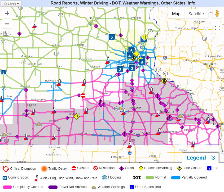 |
| Travel conditions during the evening of Dec 1. |
| Impact messaging | Up to 4 points |
| Impacts were clearly conveyed and partners responded accordingly. Positive feedback was received. | 4 |
| Overall, impacts were conveyed well, but some impacts were over or underestimated. Mostly positive feedback was received. | 3 |
| Impacts could have been more clearly stated. Feedback was mixed. | 2 |
| Impacts were not clearly defined. Mostly negative feedback was received. | 1 |
| Impacts were opposite of what was forecast. Feedback was negative. | 0 |
| 4 |
 |
Media use of NWS Web News Stories is encouraged! Please acknowledge the NWS as the source of any news information accessed from this site. |
|

