
A prolonged atmospheric river will continue impacting the Pacific Northwest with heavy rainfall which has lead to areas of urban and river flooding along with gusty winds into Thursday. A clipper will bring heavy snow, some mixed wintry precipitation, and gusty to high winds across the northern Plains, Upper Midwest, and the Great Lakes into Thursday morning. Read More >
A strong upper level storm system developed off the Pacific coast near Thursday and Friday (2/27-2/28/2014) with upper level ridging and surface high pressure persisting across the central U.S. As the ridge broke down and shifted eastward through Friday (2/28/2014) into Saturday (3/1/2014), the strong cyclone begin to move eastward across the southwestern U.S. As this upper level disturbance approached the Southern Plains, a stout surface low developed over the Panhandles and with it, brought strong southerly surface winds across the region. These winds transported moisture into the lower levels of the atmosphere through Friday and Saturday.
As the upper level low approached, a strong cold front descended across the Central Plains, providing a focus for lift. However, above this surface front, a stout warm layer developed, with temperatures reaching 10 C. This combined with the very cold air at the surface resulted in a very tricky forecast with regards to precipitation types. This warm air also created a whole new dynamic, which was elevated instability. Normally, with such a deep warm layer, or nose, if you will, results in freezing rain at the surface. Basically, the warm air melts the frozen precipitation above the ground, 3000 to 4000 feet above ground level (AGL), and then freezes as it makes contact with the surface, which is below freezing.
As precipitation started late Saturday through Sunday, it was quickly apparent, that with such cold temperatures at the surface/near ground, the melted precipitation was able to refreeze before reaching the ground, resulting in snow/sleet mix, and sometimes a mixture of all three precipitation types, snow, sleet, and freezing rain. Adding to the excitement during the day Sunday, the increased instability across the region well above the surface, 3000 to 4000 feet AGL, thunder and lightning increased as the upper level wave provided ample lift for thunderstorm development.
However, instead of rain, these storms produced intense sleet and snowfall across the region. The heaviest snow and sleet amounts fell across northern Oklahoma, where anywhere from 5-7 inches was reported. Across the central Oklahoma, snowfall totals anywhere from 2-4 inches north of the OKC metro and 1-2 inches were reported across the metro and as far south as Altus, Lawton, Ardmore, and Durant. As the upper wave departed the region to the east late Sunday night, snow and sleet ended across the region through the evening hours.


Total Snowfall Amounts for the March 1-2, 2014 Winter Weather Event in Southern Oklahoma and North Texas
NWUS54 KOUN 031442
LSROUN

PRELIMINARY LOCAL STORM REPORT
NATIONAL WEATHER SERVICE NORMAN OK
841 AM CST MON MAR 03 2014

..TIME...   ...EVENT...      ...CITY LOCATION...     ...LAT.LON...
..DATE...   ....MAG....      ..COUNTY LOCATION..ST.. ...SOURCE....
            ..REMARKS..

0700 AM     SNOW             GARBER                  36.44N 97.58W
03/03/2014  M5.0 INCH        GARFIELD           OK   PUBLIC

0700 AM     SNOW             MUTUAL                  36.23N 99.17W
03/03/2014  M2.0 INCH        WOODWARD           OK   CO-OP OBSERVER

0700 AM     SNOW             5 W MEEKER              35.50N 96.98W
03/03/2014  M1.0 INCH        LINCOLN            OK   CO-OP OBSERVER

0700 AM     SNOW             JEFFERSON               36.72N 97.79W
03/03/2014  M4.0 INCH        GRANT              OK   CO-OP OBSERVER

0700 AM     SNOW             HARDY                   36.97N 96.80W
03/03/2014  M4.0 INCH        KAY                OK   CO-OP OBSERVER

0700 AM     SNOW             BLACKWELL               36.80N 97.28W
03/03/2014  M5.0 INCH        KAY                OK   CO-OP OBSERVER

0700 AM     SNOW             OKARCHE                 35.73N 97.98W
03/03/2014  M2.0 INCH        KINGFISHER         OK   CO-OP OBSERVER

0700 AM     SNOW             PONCA CITY              36.70N 97.08W
03/03/2014  M4.0 INCH        KAY                OK   CO-OP OBSERVER

0700 AM     SNOW             BLANCHARD               35.13N 97.68W
03/03/2014  M1.0 INCH        GRADY              OK   CO-OP OBSERVER

0700 AM     SNOW             SAYRE                   35.30N 99.64W
03/03/2014  M2.0 INCH        BECKHAM            OK   CO-OP OBSERVER

0700 AM     SNOW             PERKINS                 35.98N 97.03W
03/03/2014  M4.0 INCH        PAYNE              OK   CO-OP OBSERVER

0700 AM     SLEET            CHATTANOOGA             34.42N 98.65W
03/03/2014  M0.50 INCH       COMANCHE           OK   CO-OP OBSERVER

0700 AM     SNOW             ERICK                   35.21N 99.87W
03/03/2014  E0.5 INCH        BECKHAM            OK   CO-OP OBSERVER

0700 AM     SNOW             WILEY POST AIRPORT      35.53N 97.65W
03/03/2014  M1.3 INCH        OKLAHOMA           OK   CO-OP OBSERVER

0700 AM     SNOW             3 SSE NORMAN            35.18N 97.42W
03/03/2014  M0.2 INCH        CLEVELAND          OK   CO-OP OBSERVER

0700 AM     SNOW             FILLMORE                34.27N 96.50W
03/03/2014  M0.5 INCH        JOHNSTON           OK   PUBLIC

0700 AM     SNOW             LEEDEY                  35.87N 99.35W
03/03/2014  E1.0 INCH        DEWEY              OK   CO-OP OBSERVER

0700 AM     SNOW             ENID                    36.40N 97.88W
03/03/2014  M3.0 INCH        GARFIELD           OK   CO-OP OBSERVER

0700 AM     SLEET            EDMOND                  35.65N 97.48W
03/03/2014  M1.00 INCH       OKLAHOMA           OK   CO-OP OBSERVER

0700 AM     SNOW             PERRY                   36.29N 97.29W
03/03/2014  M5.0 INCH        NOBLE              OK   CO-OP OBSERVER

0700 AM     SNOW             ALVA                    36.80N 98.67W
03/03/2014  M5.4 INCH        WOODS              OK   CO-OP OBSERVER

0700 AM     SNOW             FREEDOM                 36.77N 99.11W
03/03/2014  M4.0 INCH        WOODS              OK   CO-OP OBSERVER

0700 AM     SNOW             HELENA                  36.55N 98.27W
03/03/2014  M0.4 INCH        ALFALFA            OK   CO-OP OBSERVER

0700 AM     SNOW             MADILL                  34.09N 96.77W
03/03/2014  M0.1 INCH        MARSHALL           OK   CO-OP OBSERVER

0700 AM     SNOW             3 E ANADARKO            35.08N 98.19W
03/03/2014  M0.5 INCH        CADDO              OK   CO-OP OBSERVER

0700 AM     SNOW             3 NE STILLWATER         36.15N 97.02W
03/03/2014  M2.0 INCH        PAYNE              OK   PUBLIC

0700 AM     SNOW             1 N ELMORE CITY         34.64N 97.40W
03/03/2014  M2.5 INCH        GARVIN             OK   PUBLIC

&&

$$

DW
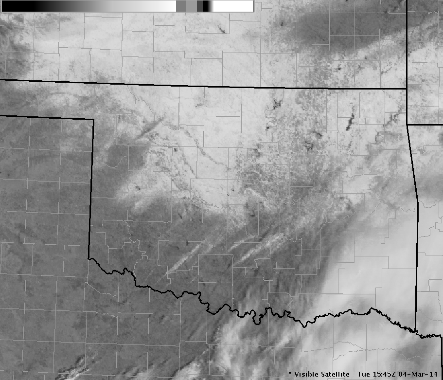
Visible Satellite Image at 9:45 AM CST on March 4, 2014 Showing the Snow and Sleet Field in Oklahoma

Blair, OK - Photo Courtesy of Albert Tyner |

Bridge Creek, OK - Photo Courtesy of Donna Strother |

Edmond, OK - Photo Courtesy of Kim Moyer |

Norman, OK - Photo Courtesy of Julia |

Pauls Valley, OK - Photo Courtesy of Stacy Mayo |

Wynnewood, OK - Photo Courtesy of Chance Plett |
Winter Weather Briefing - March 1, 2014
Winter Weather Briefing - February 28, 2014

