Springfield, MO
Weather Forecast Office
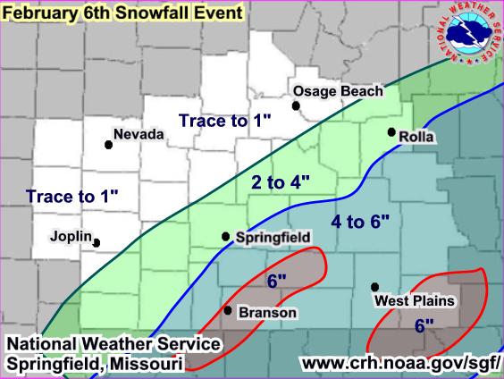
...February 5th-6th Winter Storm Summary...
A couple of upper level disturbances combined with Pacific and Gulf moisture to produce 2 rounds of snow over the Missouri Ozarks and southeast Kansas. The first wave of snow began late on the 5th of February and continued through much of the overnight hours. This wave of snow generally brought 1 to 2 inches of snow with isolated 3 inch amounts.
The second and stronger of the two waves started bringing snow into the area by sunrise on the 6th, and continued through around mid evening. The combination of the two upper level waves brought total snow accumuluations of 4 to 6 inches across extreme southern Missouri. Below is a map of the snowfall amounts.
Current Hazards
Experimental Graphical Hazardous Weather Outlook
Submit a storm report
Local Storm Reports
Current Conditions
Observations
Lake Levels
Snowfall Analysis
Road Conditions
Satellite
CoCoRaHS
Graphical Conditions
Regional Max/Min Temp and Precip. Table
Precip. Analysis
Forecasts
Forecast Discussion
Fire Weather
Aviation
GIS Forecast Maps
Activity Planner
Severe Weather
Winter Weather
Hurricanes
FAA Center Weather
Space Weather
Climatology
Records and Normals
Monthly Climate Summary
Local
National
Drought
Climate Science
Astronomical Data
US Dept of Commerce
National Oceanic and Atmospheric Administration
National Weather Service
Springfield, MO
Springfield-Branson Regional Airport
5805 West Highway EE
Springfield, MO 65802-8430
Business: 417-863-8028 Recording: 417-869-4491
Comments? Questions? Please Contact Us.


 Weather Story
 Weather Map
 Local Radar
 Follow us on YouTube