Hurricane Ivan: Two Different Operational Perspectives
Michael Scotten * and Kristin Hurley
National Weather Service, Birmingham Alabama
1. INTRODUCTION
Hurricane Ivan caused extensive damage and destruction across the Northern Gulf Coast and Deep South 15-16 September 2004. This hurricane had a significant impact to parts of Alabama, Florida, Georgia, and Mississippi.
Two forecasters from the National Weather Service Forecast Office (WFO) at Birmingham, Alabama, assumed two different, but important roles for the National Weather Service (NWS) before, during, and after Hurricane Ivan. One of the forecasters worked for the local office in Birmingham, while the other worked for the Regional Operations Center (ROC) at NWS Southern Region Headquarters (SRH) in Fort Worth, Texas.
In the direct path of the hurricane, WFO Birmingham took many actions to prepare for Hurricane Ivan. These actions included adjusting work schedules, issuing non-routine products, using various methods of dissemination to provide critical information to media, emergency management, state government, the American Red Cross, and to the general public. By taking these actions, WFO Birmingham accomplished its principal mission to protect life and property.
Although not in the path of the hurricane, the ROC at SRH in Fort Worth , Texas operated around the clock during Hurricane Ivan. The ROC’s main objective is to support the local NWS offices in Southern Region by helping them fulfill the mission of the NWS, to protect life and property. At the ROC during Hurricane Ivan, responsibilities were numerous and included detailing additional personnel to affected offices prior to the hurricane’s arrival, detailing staff to the Hurricane Liaison Team (HLT) at the National Hurricane Center (NHC), conducting media interviews, providing numerous state and federal government briefings, and supporting local WFO operations before and after landfall.
2. OVERVIEW OF HURRICANE IVAN
Hurricane Ivan, the ninth named storm of the 2004 Atlantic tropical season, was initially classified as a tropical depression at 2100 UTC 2 September, roughly 900 km (550 miles) southwest of the Cape Verde Islands. The storm became a hurricane at 0900 UTC 5 September, approximately 1900 km (1200 miles) east of the Lesser Antilles. The hurricane moved into the Lesser Antilles on 8 September and inflicted major damage to the islands of Grenada, Barbados, St. Vincent, and Tobago. In Grenada alone, 37 people were killed, and 90 percent of the island’s homes were damaged or destroyed.
Over the next few days, Hurricane Ivan progressed west-northwest through the Caribbean Sea. It impacted Jamaica, the Cayman Islands, Western Cuba, and the Yucatan Peninsula as a devastating Category 5 hurricane on the Saffir/Simpson scale. Following its transit through the Yucatan Channel, the hurricane moved northwest into the Gulf of America as a strong Category 4 hurricane.
Initial hurricane watches were issued for the Central Gulf Coast at 0300 UTC 14 September. These watches extended from near Morgan City, Louisiana, east to St. Marks, Florida. At this point, the hurricane was a Category 5, possessing a central pressure of 914 mb and packing winds around 70 ms -1 (140 kt). The NHC official hurricane track at that time forecast that Hurricane Ivan would make landfall near the mouth of Mobile Bay, Alabama, early on the morning of 16 September.
Later on 14 September, hurricane watches were replaced by hurricane warnings for the coastal areas of the Northern Gulf Coast from Grand Isle, Louisiana, east to Apalachicola, Florida. The warnings forced mandatory evacuations within these areas, including New Orleans, Louisiana and populated coastal communities south of Mobile, Alabama and Pensacola, Florida.
Hurricane Ivan made landfall near Gulf Shores, Alabama at approximately 0710 UTC 16 September 2004. At landfall, a reconnaissance aircraft determined that Ivan was a Category 3 hurricane with a central sea level pressure of 943 mb and estimated sustained surface winds near 56 ms -1 (112 kt). Prior to landfall, the Mobile South data buoy, located about 120 km (65 nm) south of Dauphin Island, Alabama, recorded a wave height of 16 m (52 ft) as the center of the hurricane passed nearby. Also, the Automated Surface Observing System (ASOS) at the Pensacola Naval Air Station in Florida observed an unofficial peak wind gust of 46 ms-1 (92 kt) at 0638 UTC.
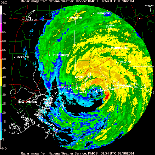
Figure 1:
Radar Image of Hurricane Ivan
just after making landfall at
Gulf Shores, Alabama
Hurricane Ivan moved north and tracked inland across Alabama during the daylight hours of 16 September. Although surface winds gradually decreased as Ivan moved north, strong damaging winds persisted across Alabama for many hours following landfall. A peak surface wind gust of 33 ms -1 (67 kt) was recorded at Greensboro in West Central Alabama, and 26 ms -1 (53 kt) gust was observed by the ASOS in Meridian, Mississippi. Sustained winds up to 22 ms -1 (45 kt) with gusts to 25 ms -1 (50 kt) were common across Central and Northern Alabama during the afternoon and evening hours of 16 September. Birmingham International Airport recorded the lowest pressure reading ever of 987 mb at 2242 UTC, which broke the previous record of 988 mb on 11 January 1918.
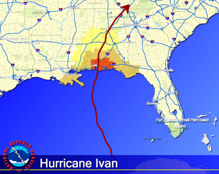
Figure 2:
Path of Hurricane Ivan as it moved
across the Gulf of America and inland
across the southeast United States.
Besides damaging winds, Ivan brought tremendous rainfall. On average, five to ten inches of rainfall occurred in the path of Ivan. An all-time 24-hour rainfall record at Birmingham International Airport of 248 mm (9.75 in) was observed on 16 September 2004.
Ivan was downgraded to a tropical depression 0300 UTC 17 September as winds weakened. Its remnants tracked northeast into the Eastern United States on 18 September.
3. WFO BIRMINGHAM OPERATIONS
3.1 Before Hurricane Ivan
WFO Birmingham took early steps to prepare for Hurricane Ivan. Fortunately, many lessons that were learned from the close call with Hurricane Frances two weeks prior to Ivan’s landfall improved the local office’s operations. Staffing was adjusted to meet the demands of customers and partners, as this was a highly publicized event. A special website link was created on WFO Birmingham’s homepage containing important information before, during, and after the storm.
Designated roles were assigned to each person to help ensure smooth operations. Two people were assigned to work 12-hour shifts as the Hurricane Operations Coordinator. This coordinator was the primary contact for the emergency managers, media, surrounding offices, and public. By having the coordinator as the primary contact, forecasters were able to focus on the ongoing weather. Hence, the office provided better quality products, forecasts, and services.
WFO Birmingham issued the Special Weather Statement (SPS) product to summarize the meteorological situation, warnings, watches, advisories, impacts, and call to action statements. This product was used as an inland Hurricane Local Statement. The initial SPS was issued two days prior to landfall and then continually issued through the entire event. The SPS was read live on NOAA Weather Radio (NWR) to stress the importance of potential impacts from Ivan on Alabama.
Statewide emergency manager briefings were given four days prior to Ivan’s landfall. These were given twice a day via 800 Mhz, a two-way radio system designed for communications of emergency managers in Alabama. At any given briefing, up to 500 local officials were listening in to make critical decisions based on forecast impacts.
Briefings were given to hundreds of local American Red Cross directors regarding Ivan’s impacts to determine shelter preparations. Approximately, 143 shelters were activated in Alabama. The Director of the American Red Cross Birmingham chapter, Cindy Bahri, quoted, “Your (Forecaster) briefings from the Birmingham weather office really helped us make decisions. Thank you so much!”
Besides briefing the emergency managers and the American Red Cross, WFO Birmingham gave hundreds of briefings and interviews to the media as early as Sunday, 12 September, four days prior to landfall. The briefings provided detailed meteorological reasoning to newspapers, television stations, and radio stations. At least 15 press conferences, several of which broke into regular programming on every station in Tuscaloosa, Birmingham, and Montgomery, were given live with the latest information from WFO Birmingham. Nationally, MSNBC and CNN used weather briefings given by WFO Birmingham on a constant basis. Interestingly, a live interview was given to the South African radio network as well.
3.2 During Ivan
As the hurricane struck Alabama, WFO Birmingham was fully prepared for Ivan. Additional staffing was scheduled where at least four forecasters, one electronics technician, and one information technology officer were on duty during any given eight hour shift. The administrative assistant was used to help keep track of media interviews, gather information for briefings, and answer telephone calls.
Management from WFO Birmingham staffed the Alabama State Emergency Operations Center (EOC) around the clock. By doing this, briefings could be given to Federal Emergency Management Agency (FEMA), Department of Transportation, Department of Homeland Security, and Department of Defense from one central location. Press conferences with Alabama Governor Bob Riley and FEMA Under Secretary Michael D. Brown were given by WFO Birmingham. The Alabama Director of Homeland Security James Walker said, “It was critical to have the partnership between federal, state, and county officials. Having a National Weather Service meteorologist from the Birmingham office in our state EOC kept critical information flowing to the Governor to make important evacuation and sheltering decisions.”
Yahoo Instant Messenger (IM) was a valuable communication tool during Ivan. WFO Birmingham used this service to directly communicate with local media to exchange critical information.
Constant communication via telephone, 800MHz radio system, and Yahoo Instant Messenger (IM) continued throughout the event. Ken Graham, the Meteorologist-In-Charge of WFO Birmingham, quoted, “This (event) is the first time in my career where telephone and 800MHz updates were more important than the traditional services during the event. This is proof the world has changed and new methods of service must be constantly created and tested.”
3.3 After Ivan
Flooding from heavy rainfall and damage from numerous downed trees and power lines occurred with the departure of Ivan. High water rescues, significant flash flooding, and potential dam breaks led to mass evacuation of homes in the Birmingham area during and after Ivan moved through. At one point, there were approximately 1.3 million customers without power in Alabama after Ivan had struck. A hotel in Prattville, Alabama was evacuated as the roof collapsed, destroying 45 rooms.
Although Ivan brought damaging winds and heavy rainfall to Alabama, the lack of fatalities was a result of great preparation and a unified message sent through the NWS, media, and emergency management. In fact, there were no fatalities in the WFO Birmingham county warning area. Alabama Governor Bob Riley said, “The National Weather Service did a great job for us. We have never been more prepared.”
The lack of injuries and fatalities according to local emergency managers can be attributed to the general public taking the situation seriously and staying home. Schools, government agencies, and businesses were shut down statewide. There was very little traffic on the roadways when Ivan moved through Alabama.
4. ROC OPERATIONS
To facilitate better service to the customers of the NWS and provide interaction between field and regional staff, the ROC at SRH began a Duty Officer Program in 2000. The Duty Officer Program is open to hydrologists and meteorologists at individual WFOs who are willing to work on a temporary duty assignment at SRH for a period of four weeks.
The Southern Region ROC Duty Officer is referred to as the "weather and hydrologic" expert at SRH. The ROC Duty Officer maintains a constant weather watch on developing weather situations across the entire Southern Region of the NWS. The officer also assists various program leaders on issues related to significant weather events. Depending on the season, a ROC Duty Officer may work with all types of hazardous weather including severe thunderstorms, flooding, excessive heat, and tropical systems.
The ROC Duty Officer is responsible for briefing the Regional Director and other SRH staff members on past, present, and future weather events. The ROC Duty Officer also provides briefings to organizations such as FEMA, NWS headquarters, media, and state emergency management agencies.
The Regional Operations Center has five different levels of operations:
The ROC provided valuable support to the NWS mission delivery during Ivan. The ROC moved to Level 3 staffing on Friday, 10 September, then moved quickly into Level 4 operations, 24-hour on-site support, on Sunday, 12 September, and remained at Level 4 operations through Thursday, 16 September.
4.1 Before Ivan
The Southern Region ROC began operating around the clock to support the local office's mission to protect life and property from Hurricane Ivan once a Tropical Storm Watch was issued for the Lower Keys in Key West, Florida.
Once a Tropical Storm Watch was issued, preparations began immediately at SRH in support of Ivan. Staffing was a major concern at coastal offices as many areas had already been hit hard with previous tropical systems during the past month. One meteorologist who was already on temporary duty in Florida for Hurricane Frances was once again instructed to stay for Ivan. This meteorologist, from WFO Lake Charles, was sent to WFO Tampa Bay as early forecasts tracked Ivan close to the Tampa, Florida area.
Once the forecast track of Ivan zoned in on the Northern Gulf Coast, more NWS personnel were sent to these locations. A hydrologist from WFO Austin/San Antonio was detailed to WFO Tallahassee to help with potential flooding problems. WFO Tallahassee's area had already received torrential rains earlier from Tropical Storm Bonnie, Hurricane Charley, and Hurricane Frances. An additional forecaster from WFO Fort Worth was sent to support the operational staff at WFO New Orleans for potential hazardous weather associated with Hurricane Ivan.
Two additional forecasters from WFO San Juan and San Angelo were sent to WFO Miami, which is co-located with the NHC, to help with Spanish-speaking needs including media interviews.
The Lower Mississippi River Forecast Center sent their operational staff and backup equipment to WFO Lake Charles to guarantee that operations would remain intact in case Ivan made landfall near Slidell, Louisiana.
The ROC Duty Officer began immediately contacting all offices, which were potentially in the path of Ivan, to assess staffing needs and equipment issues. Operational Readiness Statements were then prepared explaining an office's potential staffing concerns and equipment problems. These statements were sent to all SRH personnel in order to resolve any problems before Ivan's landfall.
As soon as Ivan threatened the Northern Gulf Coast, the 6-hourly NHC conference calls regarding the hurricane became very important to inland offices. All coastal forecast offices in Southern Region are equipped with Hurricane Hotline phones, which provide a direct connection with the NHC. Inland offices do not have this luxury, so a conference call bridge was set up by the ROC Duty Officer to link the inland offices to these NHC briefings
The ROC Duty Officer constantly gave weather briefings on Hurricane Ivan to several government agencies including FEMA Region IV and VI, NWS Headquarters, Texas Department of Emergency Management, and Louisiana Office of Homeland Security and Emergency Preparedness. The ROC also conducted several media interviews to local, regional, and national news agencies.
A Hurricane Liaison Team (HLT) consisting of NWS and FEMA personnel was dispatched to the NHC to help field calls and give media interviews. The ROC Duty Officer remained in constant contact with the HLT staff before, during, and after Ivan.
Southern Region initiated a plan to balance internet traffic from radar.weather.gov to make sure that the website would remain up and running continuously during Ivan. This process allowed Southern Region to maximize bandwidth to easily serve all weather data. All customers and partners continued to receive critical weather information as needed without any reported problems during Hurricane Ivan due to Southern Region's plan.
4.2 During Ivan
To better support vital state and Federal partners, two SRH staff members were deployed to FEMA Region VI and the Louisiana Office of Homeland Security and Emergency Preparedness. The SRH staff members provided direct weather support to these agencies to help make critical decisions and to allocate resources.
The ROC Duty Officer constantly called affected WFOs including River Forecast Centers and Center Weather Service Units. Information was gathered regarding the status of employees and equipment during Hurricane Ivan. This information along with the latest data on Ivan was put into a Regional Impact Statement that was sent to NWS Headquarters and Southern Region personnel.
4.3 After Ivan
Once Ivan moved out of the Southeastern United States, the ROC Duty Officer along with several SRH personnel began immediately gathering information on the status of each affected WFO. Luckily, only minor damage occurred to an outbuilding at WFO Mobile. A preliminary report was written about Ivan describing the overall effects it had on local forecast offices, state operations, and federal agencies. This report was sent to NWS Headquarters, National Oceanic and Atmospheric Administration, and Congress.
In total, approximately 224 man-hours were devoted to ROC operations in support of Hurricane Ivan. These resources were in addition to the regional support provided for Hurricane Jeanne, which made landfall in Puerto Rico on 15 September.
Southern Region Web Services provided weather information to 20 million visitors. During the five-day period, 4.1 trillion bytes of information were served, which is the equivalent of downloading the front page of the Washington Post 15.3 million times. The Southern Region website set a new record for most visitors in one day on 15 September, the day before Ivan made landfall.
5. CONCLUSION
Although Hurricane Ivan caused extensive damage and destruction across the Northern Gulf Coast and Deep South 15-16 September 2004, the loss of life and injuries were minimized as a result of better communication between the NWS, media, emergency management, the American Red Cross, and the public. By working together, planning early and conveying a sense of urgency, people took proper actions.
6. ACKNOWLEDGEMENTS
Special thanks are given to Jud Ladd, Tom Bradshaw, and Mike Coyne at Southern Region Headquarters for their contributions to this paper. Also, much appreciation goes to Kenneth Graham, Meteorologist-In-Charge at WFO Birmingham, for his input into this paper. Finally, special recognition is given to the staffs at WFO Birmingham, the Regional Operations Center, and to all Southern Region Weather Forecast Offices for their outstanding efforts during Hurricane Ivan.

