|
Many times during the winter months, central Alabama finds itself on the edge of disaster. There are many times when our counties are less than 100 miles away from having large amounts of winter precipitation, whether that is ice pellets, snow or even worse...freezing rain. Friday morning was no different. Portions of NW Alabama, including the Muscle Shoals area, received freezing rain accumulations Friday morning and afternoon. The freezing rain was seen as far south as Winston and Marion Counties. The question is, why did these two counties see the freezing rain and the Birmingham area did not? We will attempt to illustrate why the Birmingham area was spared Friday.
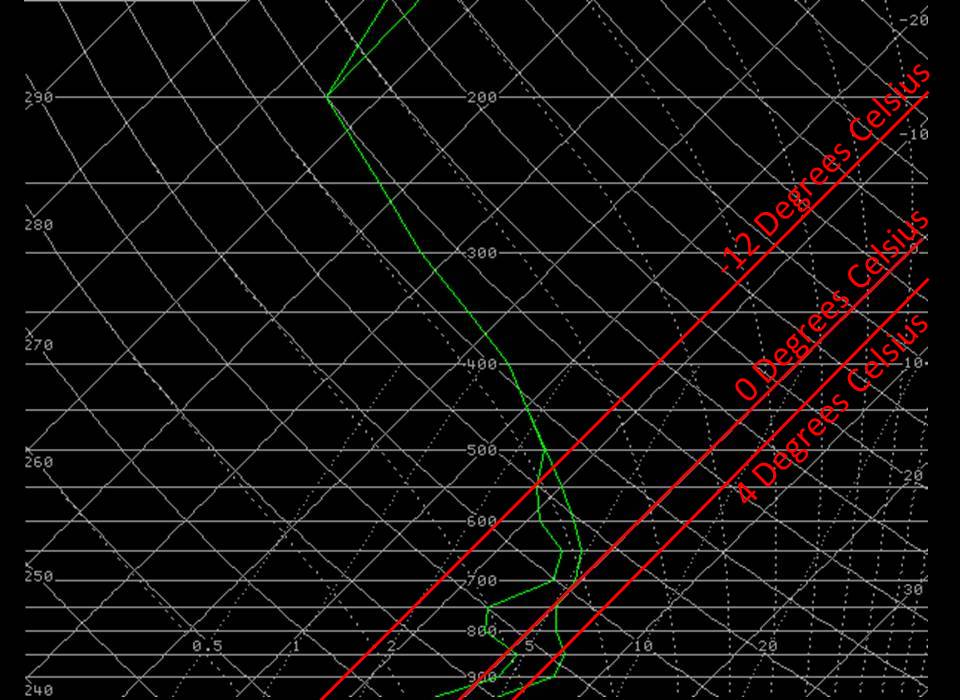
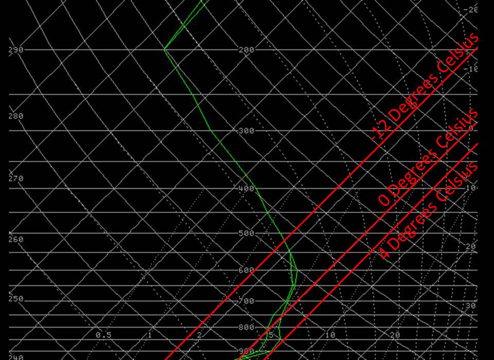
The two graphs displayed here are known as Skew-T graphs. They are a depiction of what the atmospheric conditions are over a given location. Many times, Skew-T graphs are created from the release of a weather balloon with an attached instrument called a radiosonde. After release, the radiosonde sends a signal back to our office that gives us four parameters: environmental temperature, dew point, atmospheric pressure and wind speed and direction. These two graphs are actually computer generated in order to help us maintain a current picture of what's going on in central Alabama. The two green lines on each graph reflect the environmental or air temperature (green line furthest to the right) and the dew point temperature (furthest green line to the left). These two lines can tell meteorologists many things, such as, the closer they are together, the more moisture that is present in that layer of the atmosphere. The solid horizontal lines (white) are pressure levels in the atmosphere. The solid lines running from bottom left to top right indicated temperature in degrees celsius.
So what are these two Skew-Ts telling us about Friday's weather? In the winter months, forecasters use the Skew-T and a method called "The Top-Down Approach" in order to determine what type of precipitation is going to reach the ground. The top graph is a Skew-T over Birmingham and the bottom is over northern Marion County, both at noon Friday. In this method, a forecaster examines three different layers of the atmosphere. For simplification, we have highlighted the three most important temperature lines:
The first layer to analyze is the one above -12 degrees celsius. If the atmoshpere is saturated (the green lines close together) above -12 degrees celsius, then it is ripe for the growth of snow crystals. Atmospheric saturation has occured above -12 degrees celsius, so we already have snow forming.
The next layer to analyze is the one just above the surface. If there is a warm layer of air just off the surface and the temperature in this layer is warmer than 4 degrees celsius, precipitation will usually fall in the form of rain. In the case of the atmosphere in Birmingham (above), the temperature in the warm layer is approximately 6 degrees celsius. This means it's too warm to get anything but rain. In Marion County (below), the warm layer temperature is slightly cooler than 4 degrees celsius. This is warm enough for the snow crystals to melt, so at this point, the snow crystal has turned into a rain droplet, but depending on what's going on at the surface...there may still be time for some type of winter precipitation to occur.
Finally, we must examine the layer closest to the surface. If the temperature at the surface at or below freezing, as was the case in northern Marion County Friday, rain droplets will freeze upon contact with the ground. This is why freezing rain was seen in northern portions of the county. With temperatures at 31 to 32 degrees, the rain droplets froze upon contact with the ground (or the trees or the power lines).
In summary, over both areas, the upper atmosphere was ripe for snow crystal growth, but over Birmingham, there was a warm enough layer just above the surface to melt those snow crystals, allowing only rain to reach the ground. In Marion County, the layer above the surface was warm enough to melt the snow crystals, and with the temperature right at or just below freezing at the surface, when the precipitation reached the ground , it was cold enough to freeze on contact.
|


 Follow us on YouTube