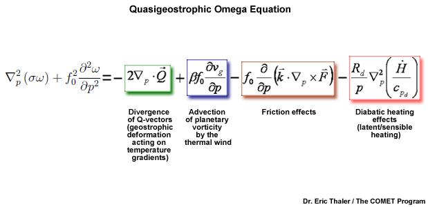
An example of complex calculations done within weather modelling. This particular equation is used to solve for vertical motions in the atmosphere.
The history of using mathematical models to forecast weather and water can be traced back to the early 20th century but only became useful with the advent of computers. Once computers were available however, numerical weather prediction evolved quickly. As computing power grew, forecasts were able to be computed more regularly but their skill levels were far below the manual techniques at the time. Then, into the1970s, increased computing power combined with an influx of new observations, including satellite data, kickstarted the field of weather modelling as they began to compute more data with more speed and skill. In modern times, continuing advancements have allowed for more complex models to be run at a finer scale over the entire globe, further increasing their predictive skill.
Scientists have also developed what we call “Ensemble modelling.” In this method, the same model is run multiple times with the initial conditions slightly altered. This procedure outlines a multitude of potential outcomes where the differences in the individual model forecasts help us to assess the uncertainties in the forecast.
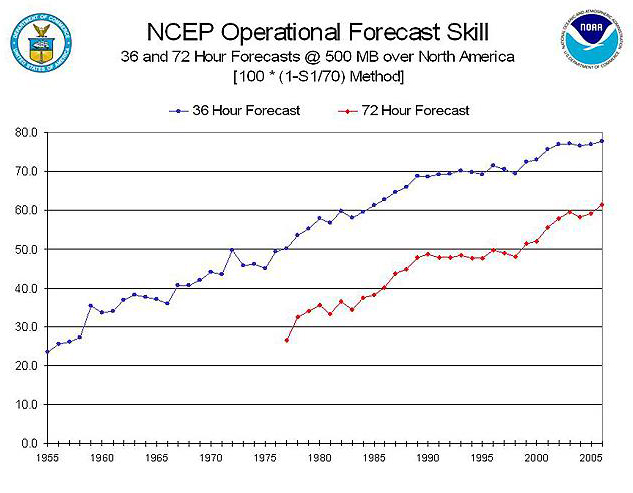
NOAA Operational Model forecast skill scores monitored from 1955 - 2006 (higher skill score = more accurate forecast)
The critical starting point for all of our models is a reliable and expansive network of observations. We need to have accurate initial data in order for the calculations to work properly! Modern models are able to ingest observation from numerous sources around the world. Satellite data, aircraft observations, weather balloons, stream gauges, even information from citizens with personal weather stations can all be ingested. Then, once we’ve established what the atmosphere currently looks like in data form, we can then input that data and run our model.
All weather models work on the same basic principles, solving for a large number of complex equations for various locations at both the surface, and different heights (layers) of the atmosphere. These equations solve for many parameters such as temperature, dew point, wind speed, in addition to many others. Once all these calculations have been completed for a given time step, the solutions can be put together to form a picture, or map, of what the future state of the atmosphere looks like based on the model’s calculations. This new set of variables is then input back into the model and repeatedmany times over, giving us a range of forecasts valid from a few hours to many months into the future!
Today, the NWS runs an extensive suite of weather models, ranging from local, high-resolution, short-term models that help pinpoint severe weather (the High-Resolution Rapid Refresh model (HRRR)), medium resolution models that produce quality short-range forecasts for the North American continent (the North American Model (NAM)), to our Global Forecast System (GFS) that we use not only for weather in the U.S. but for the entire globe. Complementing our weather models are a suite of other environmental simulations like the National Water Model as well as models that predict ocean/lake waves and currents, ice cover, aerosols, and the land surface. Improvements to these models are continuous as NOAA and the NWS work towards the next generation of weather and environmental models that are expected to provide forecasters with more skilled guidance in order to continue our core missions in the protection of life and property.
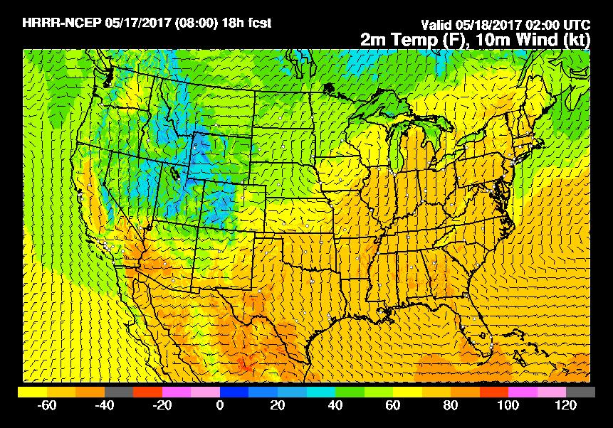
NWS HRRR model forecast of simulated surface temperature and wind speeds
For more information on the NWS’s weather and water models:

