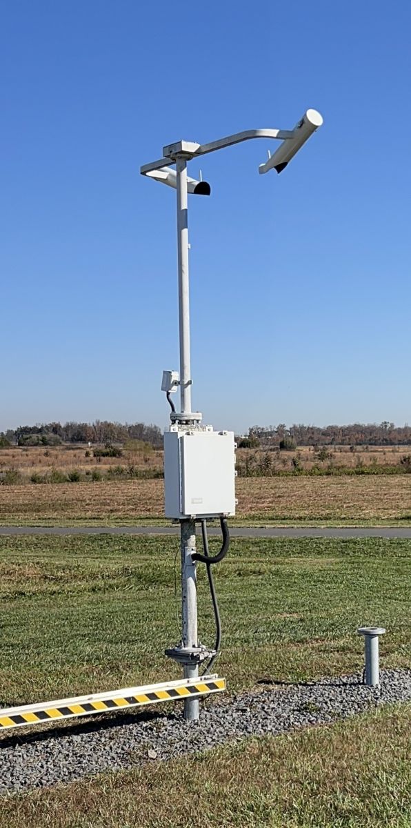
The ASOS visibility sensor operates on a forward scatter principle in which light from a pulsed Xenon flash lamp in the blue portion of the visible spectrum is transmitted twice a second in a cone-shaped beam over a range of angles. The projector and detector are protected with a lens hood and canted down at 15 degrees from the horizon to prevent snow blockage.
The detector is oriented north to minimize sun glare, particularly from low sun angles near sunrise or sunset. To optimally balance the detection efficiency and differentiation ability of the sensor under varying conditions, a nominal 45-degree horizontal incident angle is set between the projector beam and the detector field-of-view within the sampling volume. This is achieved by offsetting the projector about 45 degrees to the left (i.e., northwest) of the detector. As a result, the projector beam does not directly impinge on the detector lens. Only that portion of the beam that is scattered forward by the intervening medium in the sampling volume is received by the detector. The sensor sampling volume is 0.75 cubic feet and the sensor response time is 20 seconds. A measurement sample is taken every 30 seconds. Visibility sensor measurement accuracy is specified in reference to comparison with two NWS visibility standards. In this regard, the forward scatter sensor has shown excellent performance when compared with the "Optec" Transmissometer standards.
Visibility in METAR is reported in statute miles (SM). The reportable increments are: M1/4SM, (less than 1/4SM), 1/4SM, 1/2SM, 3/4SM, 1SM, 1 1/4SM, 1 1/2SM, 1 3/4SM, 2SM, 2 1/2SM, 3SM, 4SM, 5SM, 6SM, 7SM, 8SM, 9SM and 10SM. Note that visibilities between zero and less than 1/4 mile are reported as M1/4SM8. Measured visibilities exactly halfway between reportable values are rounded down. Visibilities of 10 miles or greater are reported as "10SM."
At some airports a second visibility sensor is placed where unique weather, not necessarily representative of the entire airport, may impact flight operations for a portion of the airport or a particular runway. The secondary meteorological discontinuity visibility sensor may be used to provide an early alert of deteriorating conditions, such as fog rolling in off a nearby bay or river. Whereas the primary visibility sensor is sited near the touch-down zone of the primary instrument runway, the second (meteorological discontinuity) visibility sensor is sited about 2-4 miles away in the most likely location for a meteorological discontinuity.
The data from the primary and meteorological discontinuity sensors are independently processed through the single sensor algorithm and then compared. Only data from the primary sensor is used in the body of the METAR.
If the primary visibility sensor is not operational, the visibility is not reported, a maintenance check indicator ($) is appended to the METAR, and no further comparisons are made. If the meteorological discontinuity visibility sensor is not operational, the remark "VISNO LOC" is added to the METAR, where LOC is the nominal location of the meteorological discontinuity visibility sensor (e.g., CF, RWY26L), a maintenance check indicator ($) is appended to the METAR, and no further comparisons made.
If both sensors are operational, a meteorological discontinuity visibility remark is reported when the visibility measured by the meteorological discontinuity sensor is less than 3 miles and is also less than the visibility measured by the primary visibility sensor by one-half mile or more. When these conditions are met, a remark in the form "VIS VALUE LOC" is added to the METAR, where VALUE is the visibility reported by the meteorological discontinuity sensor and LOC is the nominal location of the meteorological discontinuity sensor. For example, a meteorological discontinuity visibility value of 1SM on runway 26L is reported as: VIS 1 RWY26L.
A sky condition algorithm has been developed for use where cloud formation (or advection) typically occurs in (or from) a known location and results in significant concurrent differences in sky conditions over the airport. The meteorological discontinuity algorithm uses output from two CHI sensors. The primary sensor is sited near the touchdown zone of the primary instrument runway. The second CHI is typically sited 2 to 4 miles away from the primary sensor, upwind in the most likely direction of the advection, or closer to the fixed source of the unique sky condition. The second CHI serves to detect operationally significant differences in sky conditions. Information from the meteorological discontinuity sensor is included in the ASOS METAR under appropriate conditions described below. Data from the primary and meteorological discontinuity sensors are independently processed through the single sensor algorithm and then compared. Only data from the primary sensor is used in the body of the METAR.
| Back to Sensor Suite Design |

