National Weather Service United States Department of Commerce


Image of areas under threat in Hidalgo County under threat for minor river flooding and light inundation of the Banker and Main Floodways
Google Map showing threat area in Hidalgo County along Rio Grande and Banker/Main Floodway for late September into early October. Example of Hydrologic Advisory Text from mid October, 2010.

Rio Grande Risen...Again
U.S. Floodway System Put Back in Use
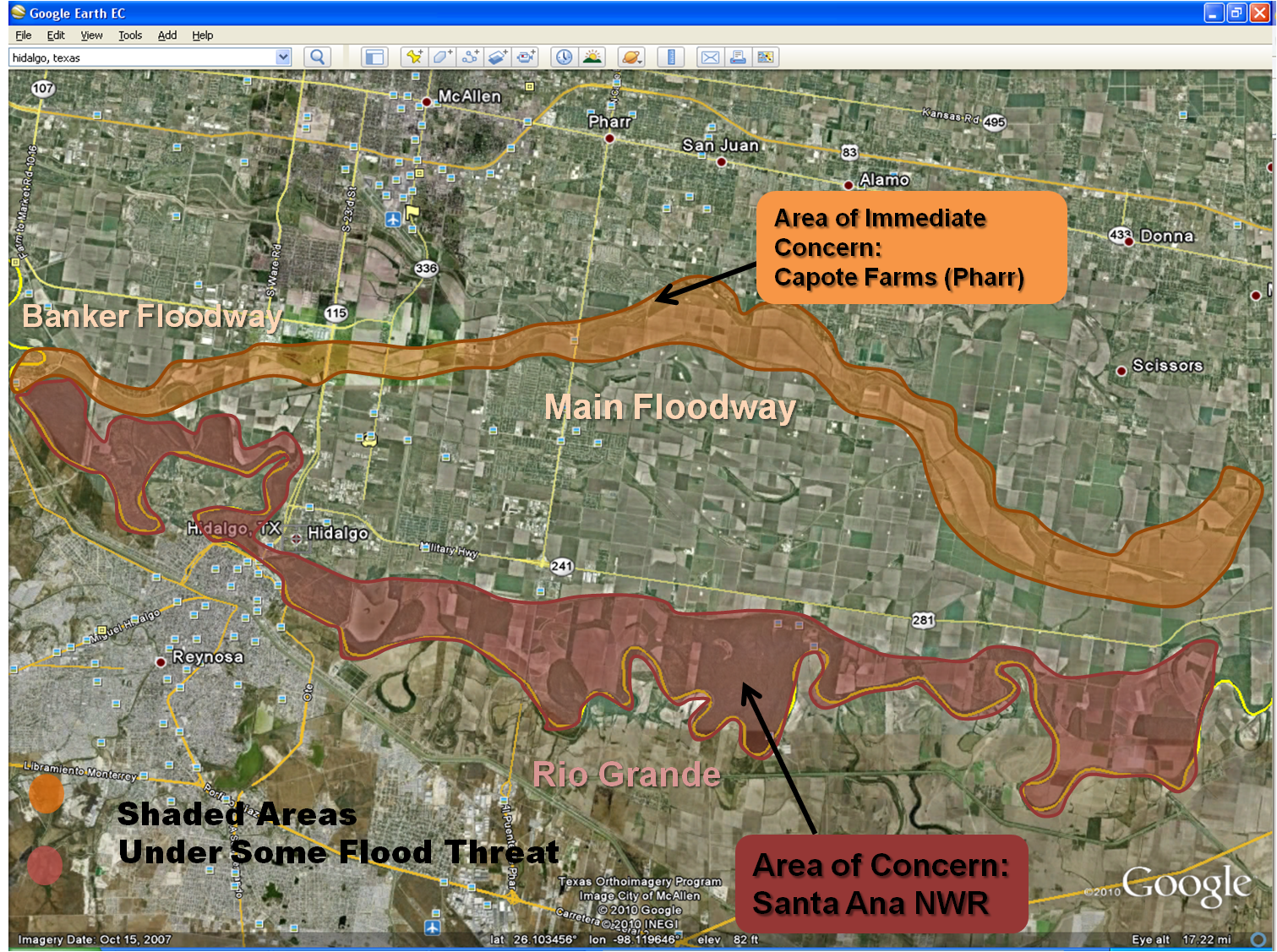
 
No July/August Repeat, but Problems Continued Through Late October 2010

Overview
Several days of persistent rains across northeastern Mexico from September 17th through the 25th brought increasing flows into the Rio Grande Basin, and these flows re–filled reservoirs along the Rio Salado and Rio San Juan River, each which released water into different sections of the Rio Grande, ultimately affecting Falcon International Reservoir and downstream, unimproved portions of the river between Roma and Peñitas (Hidalgo County). The releases shown on this map indicated continued water flowing downstream based on steady levels of water releases from Falcon International Reservoir along the U.S./Mexico border (Zapata County); and Venustiano Carranza (along the Rio Salado), El Cuchillo, and Marte Gomez (along the Rio San Juan and tributaries) reservoirs, as of October 8th, 2010. Flows into Rio Grande City had slowly decreased in early October, and eventually dropped below 40 feet or lower by October 18th. As of 11 am CDT October 8th, the stage had fallen to 44.1 feet, after peaking at 45.27 feet on October 1st, less than 3 feet below action stage (48 feet). Click here for the latest details on the Rio Grande City stage levels.

Reasons
The main culprits for the releases in northeast Mexico were initially a slow moving thunderstorm complex that developed during the evening of September 19th, and persisted into early on the morning of the 20th, which dropped perhaps 6 to 8 inches of rain. Additional rainfall on both sides of the complex, continuing until at least September 26th, produced estimates of 15 to 20 inches (below, left side of image) between Coahuila and Nuevo Leon States in the foothills and peaks of the Sierra Madre Oriental. As this water flowed into the Rio Grande, the Lower Rio Grande Valley Flood Control Project was activated for the second time in 2010. The activation was based on a combination of water flowing downstream, flows already being taken by Mexico at Retamal, and continuing high–end action stage flows along the Cameron County/Tamaulipas line – flows which were aggravated by the September 17 through 22 rains.

Impacts
During the late afternoon of September 25th, water had increased across both improved and unimproved areas of the Rio Grande, and as the Banker and Main Floodways (above) began seeing water levels increase from diversions at Anzalduas Dam, the El Capote Farms neighborhood along "I" Road and Doffing Road in Pharr was bracing for up to 2 feet of inundation by the morning of September 26th. A voluntary evacuation order had been given by Hidalgo County.

Additional pockets of heavy rainfall continued across the Mexican portion of the Rio Grande basin and tributaries through early September 27th before dry air finally plunged southward and knocked out the deep tropical moisture which has been resident across the area. The International Boundary and Water Commission are confident that water levels in the Lower Rio Grande Valley Flood Control Project (floodways) remained well below those experienced in July and August in the wake of incredible mountain rains associated with Hurricane Alex and Tropical Depression #2. Check the upper right corner of their web site for updated press releases. Updated hydrologic information for the Lower Rio Grande can be found at our Advanced Hydrologic Prediction Service webpage.

Update, October 8th: Issues continued at El Capote Farms ("I" Road/Doffing Road), Pharr; FM 1015 was closed due to high water between Baker and Gonzales Street near Progreso; high water was reported near a leaky gate on the south side of the Main Floodway, nearing a small subdivision about 4 miles south of downtown Weslaco east of Texas Boulevard; and a report from the Lower Rio Grande Valley National Wildlife Refuge of 4 feet of water or higher in some cases covering the refuge inside the levee along the river.

Until releases are significantly reduced, high water levels will continue in the Rio Grande, especially east of Anzalduas where flooding will continue at locations inside the levees. Continuing dry weather may allow a decrease in water flow later in October.

Final Update, October 21st: A month of warm weather with low relative humidity and scant rainfall finally allowed flows to decrease once and for all into all reservoirs feeding the Lower Rio Grande as October faded toward November, 2010. Release values at primary reservoirs had decreased markedly as of October 21st. Diversions into the Lower Rio Grande Valley Flood Control Project were ending, but residual high water continued to flow downstream from the National Wildlife Refuge near Santa Ana (Hidalgo County) to the Gulf. Action stage levels would continue at gaging points near San Benito and Lower Brownsville through the end of the month.

Advanced Hydrologic Prediction System rainfall estimates for September 15-22, 2010, Deep South Texas/Northeast Mexico (click to enlarge)
Map of estimated rainfall, September 18 to 25, 2010, across the Rio Grande Valley of Texas and northeast Mexico