National Weather Service United States Department of Commerce


Northwest Brooks County wildfire flares up on Satellite, June 18th, between 3 and 330 PM CDT (click to enlarge)
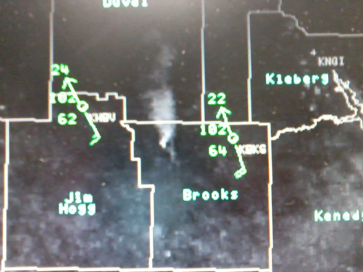
Visible satellite image showing large smoke plume in northwest Brooks County, around 330 PM June 18th, 2011.
Late afternoon aerial view of very large wildfire in Brooks County, June 19th, 2011 (click to enlarge)
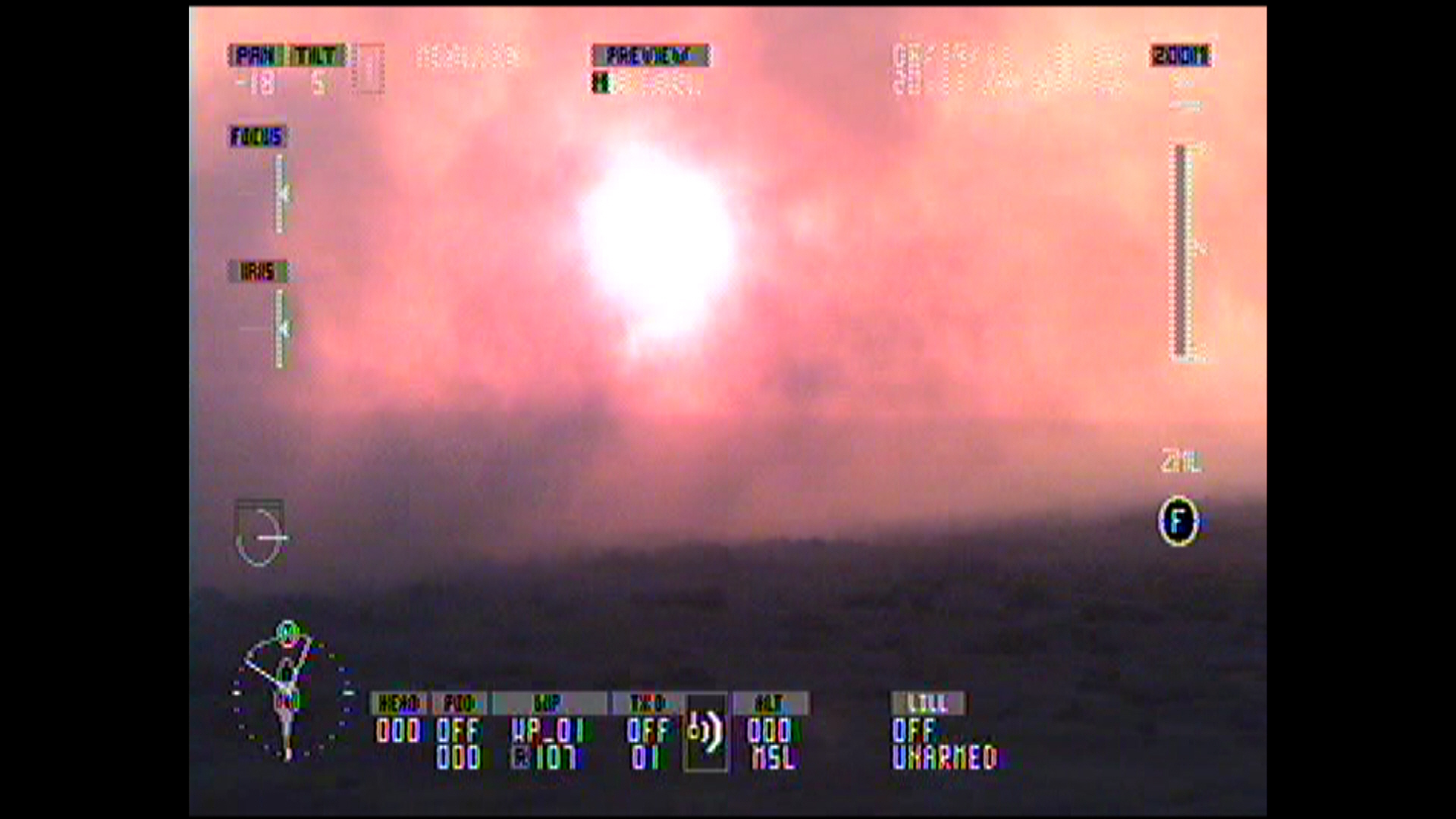
Late afternoon aerial view of sun blocked by expanding wildfire in Brooks County, June 19th, 2011. Courtesy of Texas Department of Emergency Management/Texas Forest Service.
Evening aerial view of very large wildfire in Brooks County, June 19th, 2011 (click to enlarge)
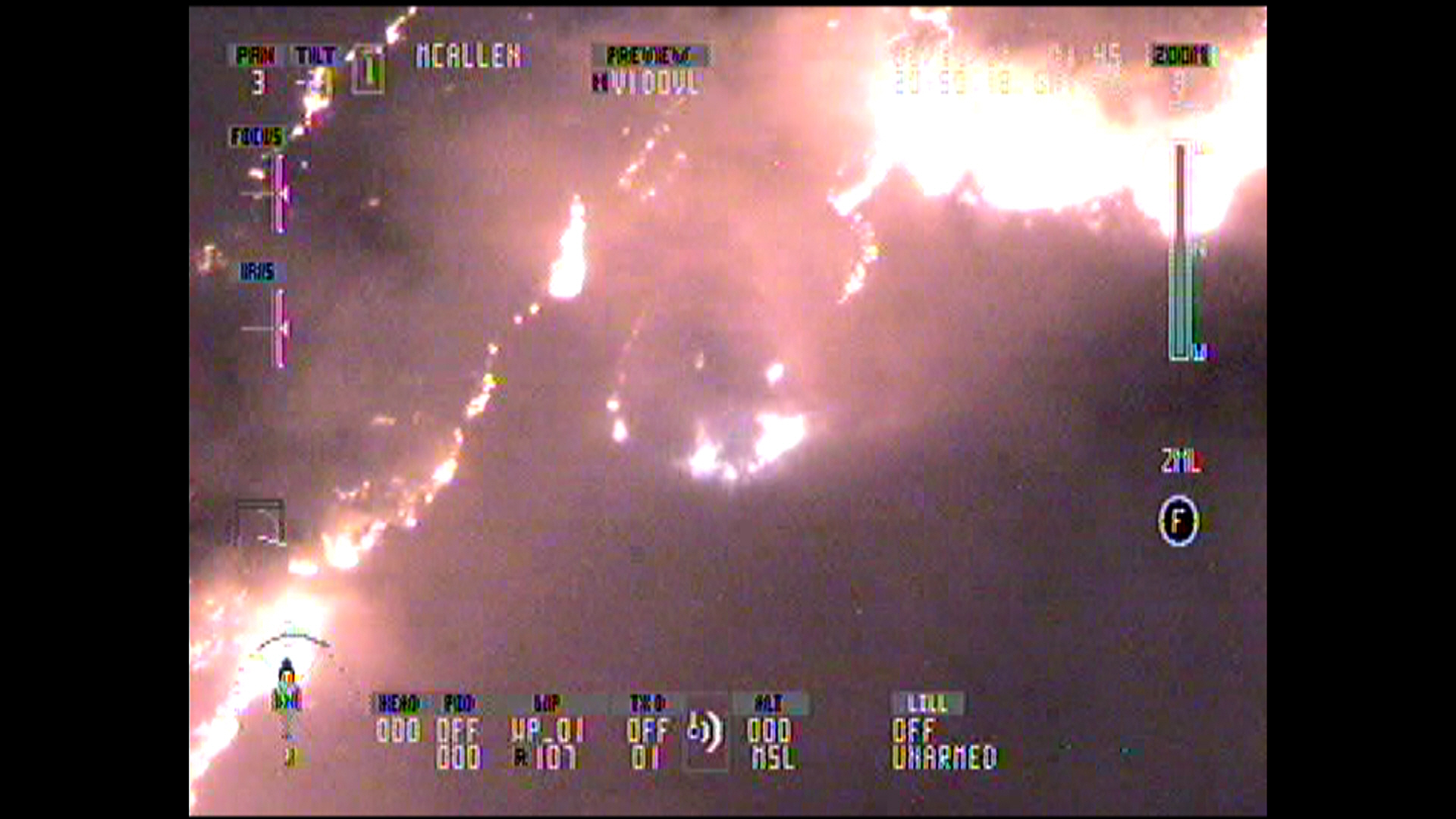
Nighttime aerial view of growing wildfire in Brooks County, June 19th, 2011. Courtesy of Texas Department of Emergency Management/Texas Forest Service.
Huge Wildfire Engulfs Western Brooks County
Record Water Year Drought; Heat/Wind/Low Humidity Turn Sparks into Conflagration on June 18th 2011

The Event

It finally happened.

After nearly nine months of record water year (Starting October 1, 2010) drought, the odds caught up to the excessively parched landscape. Presumably, sparks from a hot catalytic converter on a ranch vehicle set the rangeland ablaze in Northwest Brooks County at around 10 AM on June 18th. In rapid succession, the fire, driven by near record hot temperatures, humidity near 25 percent, highly cured fine and coarse fuels, and frequent wind gusts near or above 30 mph day and night, spread to 3300 acres by late afternoon, 8000 acres by mid evening, and more than 10,000 acres before midnight on the 18th. The fire exceeded 12,000 acres early on the 19th, and continued to grow despite some successful containment efforts. By June 20th, the acreage had reached 22,500, placing it only behind the "Four Corners/Encinitos Ranch" event of March 18, 2008, in recent years. Unofficial reports early on June 21st indicated an estimated 30,000 acres had burned in Brooks County, with the fire having neared State Highway 285, which is the main thoroughfare between the King Ranch and the Rio Grande Plains in Deep South Texas.

June 23rd Update: As of mid morning June 22nd, the fire had peaked at 32,000 acres, and was 100 percent contained after light to moderate rains and lighter winds arrived. Texas Forest Service personnel noted that the steady increase in acreage through the 21st was due to continued dry and breezy daytime conditions, but also to the firestorm environment, which kept humidities low through the night due to the localized heating and additional wind generated by the blaze, a "positive feedback" loop of sorts. A photo gallery is now available, courtesy of the Texas Forest Service.

Impacts
As of June 22nd, the blaze had burned down several unoccupied deer hunting camp buildings on or near Rancho de los Jefes, and had moved into extreme southeastern Duval County and was within a couple of miles of the Jim Hogg County line. The largest ranch affected was the SMAC Ranch; the Palo Blanco Ranch also burned. Rapid response by up to 30 fire departments from the Lower Rio Grande Valley to the Coastal Bend, along with assistance from the Texas Forest Service and state level emergency management personnel, helped "save" several homes over the weekend. At least one cow and one deer were killed by the the fire, heat, or combination. Increasing humidity, some lowering of wind speeds, and isolated to scattered showers was expected to help firefighters, which have included up to 300 first responders, gain containment and control of the situation. Updates will be provided here through June 24th.

Other Fires
The Brooks County fire was one of a few large fires to burn across parched lands of the Brush Country and Rio Grande Plains. In Zapata County, two relatively large fires burned a total of 1,600 acres on June 9th. 1,200 acres of rangeland burned from 4 PM until midnight at the Barberio Ranch and Loma Blanca Ranch, 11 miles south of Zapata. Another 400 acres burned on the Henry Garza Ranch, 13 miles east of Zapata, between 330 and 8 PM.

How Now, Drought?
Drought continued at the highest levels possible, ranging from extreme (D3) across the Brush Country and King Ranch to exceptional (D4, highest on the scale) throughout the Rio Grande Valley. Record statistics continued to pile up for the 2010/2011 Water Year–to–Date, which starts on October 1st. Just how dry had Deep South Texas been? The tables below tell the tale. The first table compares 1, 2, 3, 4, etc. month periods ending May, 2011, for Texas Climate Region number 10 (Rio Grande Valley) with long term averages. Since October, each ranking period has placed 1st or 2nd all time, except for May alone, which placed fourth. The second table compares current water year to date rainfall with prior records. Impressive are how far below the previous record the 2010/2011 lack of rainfall has been, and how far below average these rains were, between 10 and 12 inches! It’s no wonder the corn and the cattle of the Valley (photos, below) have suffered more than at any time in recorded water year history through mid June.

Rankings of recent rainfall periods for Texas Climate Region Number 10, Rio Grande Valley
 
Current Rainfall as of June 21st, Compared with Prior Records
Location
Current Rainfall (Rank)
Prior Record (year)
Rain Needed to Reach Average
Brownsville
2.78 (1)
5.88 (1952/53)
12.44 (in.)
Harlingen/Coop
4.49 (1)
5.48 (1915/16)
11.57
Raymondville
4.78 (2)
3.97 (1970/71)
11.15
Port Mansfield
2.65 (1)
2.96 (2008/09)
13.60
Sarita
6.54 (5)
3.02 (2008/09)
10.31
Hebbronville
3.44 (1)
3.81 (2007/08)
10.15
Falcon Dam
1.03 (1)
1.79 (1970/71)
10.37
Rio Grande City
1.47 (1)
2.76 (1970/71)
9.92
La Joya/Mission
0.89 (1)
4.16 (2007/08)
12.15
Mc Cook
1.21 (1)
3.13 (2005/06)
11.93
McAllen/Miller Arpt
1.47 (1)
3.74 (2005/06)
11.47
Mercedes 6 SSE
2.97 (1)
4.65 (2008/09)
11.72


Photo of a dead corn field near Los Fresnos, June 21st, 2011 (click to enlarge)
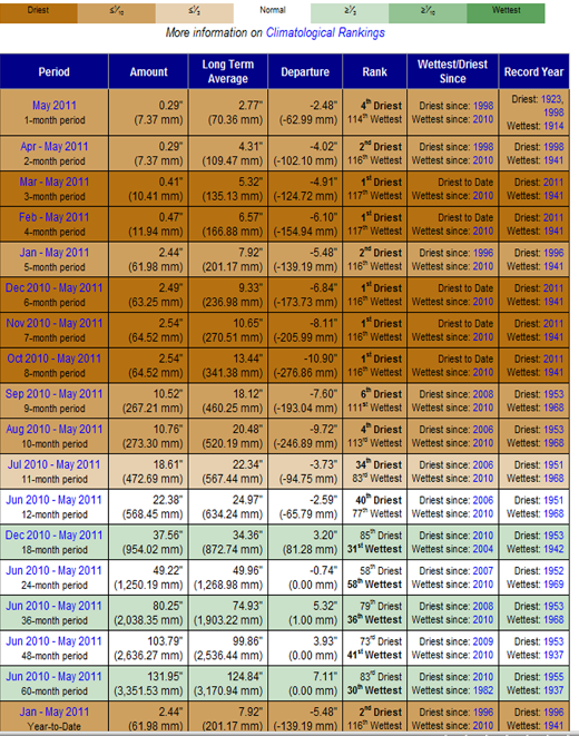
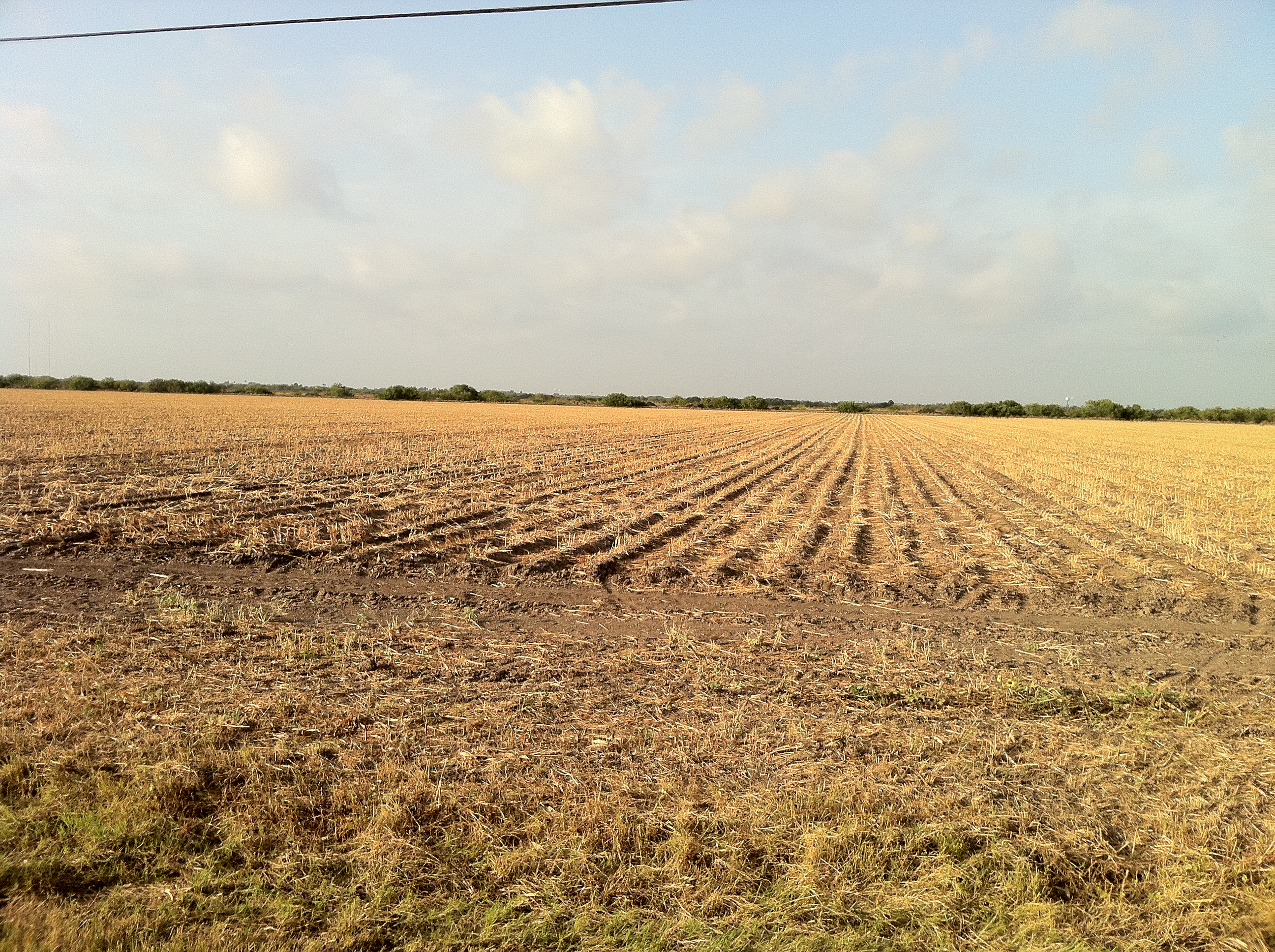
Above: Browned out corn field near Los Fresnos, June 21st, 2011, a casualty of drought and lack of irrigation outside of natural rains earlier in the spring.
Photo thin cow on a dusty plain, 4 miles north of the Port of Brownsville, June 18th 2011 (click to enlarge)
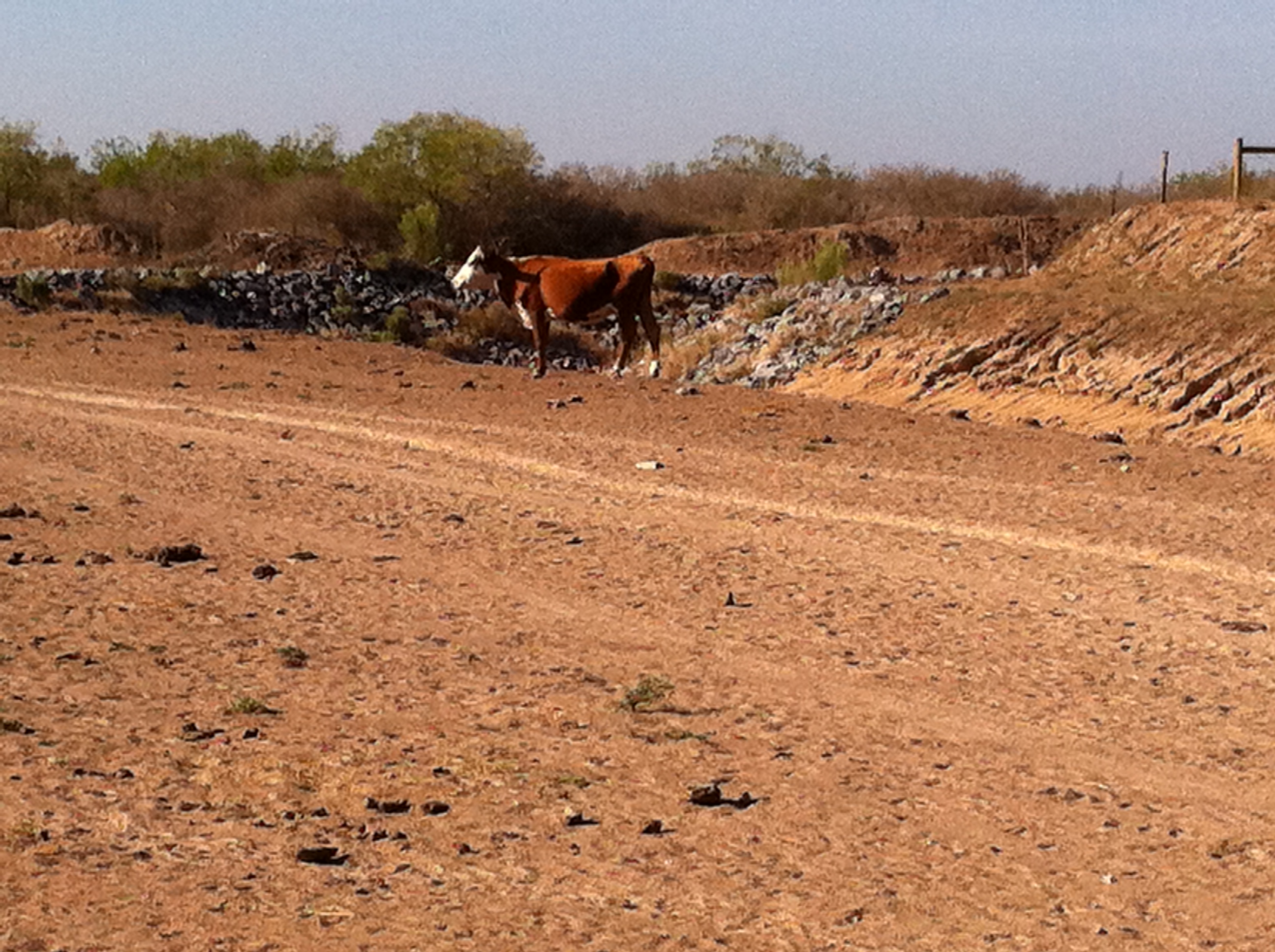
Above: Cow on a dusty plain north of the Port of Brownsville, June 18th, 2011. Note how underweight the cow is; others in the area were emaciated to skin and bones.