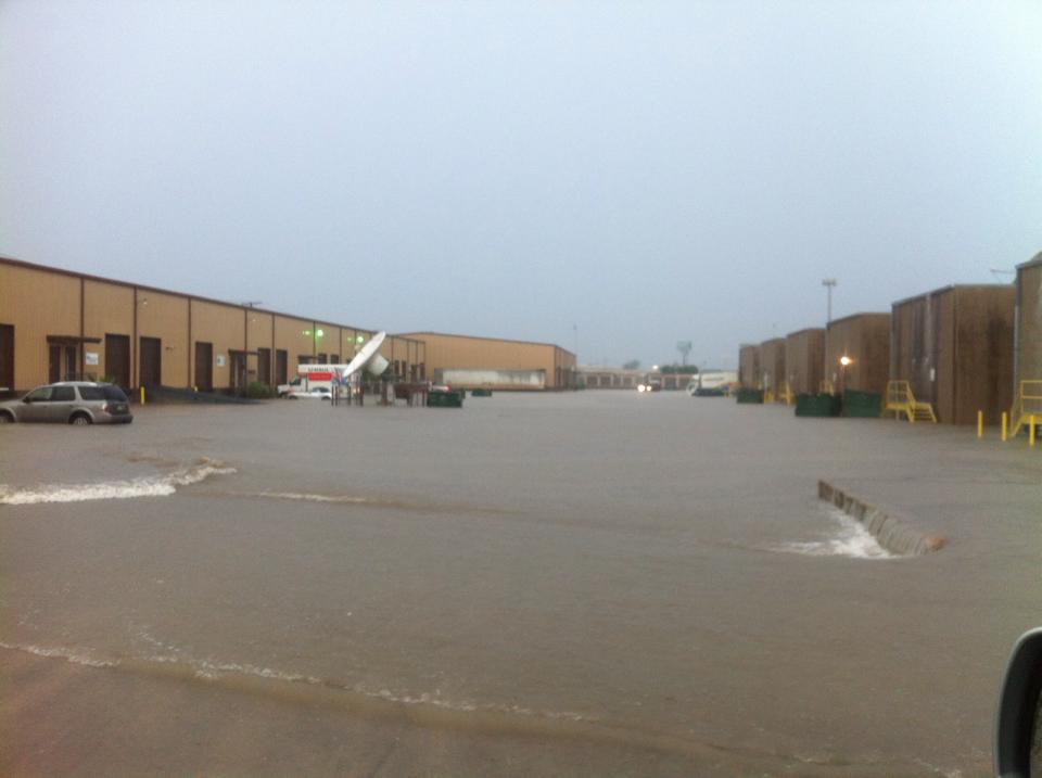
 Photos from urban/flash flooding in Brownsville on October 22, 2014. Courtesy of NWS Brownsville staff and NWS Brownsville, KGBT Channel 4 News, KRGV Channel 5 Weather, and KVEO Channel 23 Facebook pages. |
|
| Surprise! Torrential Rains Greet Brownsville Morning Commuters with Floods Two to Four Inches Inundate Parts of City, October 22, 2014 |
|
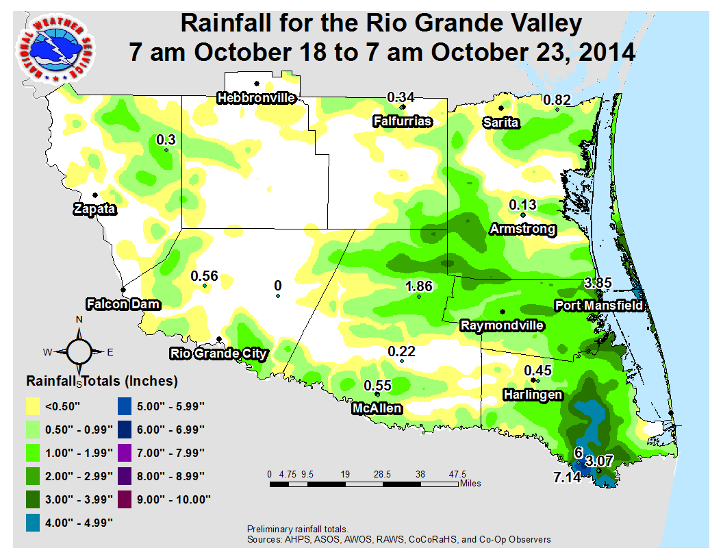 Measured and estimated rainfall from 7 AM October 18 through 7 AM October 23 for the Rio Grande Valley After the 2014 autumn season’s first drying front brought cool morning temperatures, "chamber of commerce" afternoons, and very low humidity, it seemed as if the spigot that dominated September had turned off. Mother Nature had other plans, however. Despite having limited deep tropical moisture, atmospheric lift in the form of convergence of low level air on the 18th was followed by the arrival of a weak upper level "shear zone" (which aids low level lift) on the 21st which may have helped induce a localized feed and lift of low level moisture along the Rio Grande in Cameron County on the 22nd. The result was a band of 4 to 7 inches of rain in Greater Brownsville, with other pockets of 2 to 4 inches from eastern Cameron through much of Willacy and southern Kenedy County, stretching west into northern Hidalgo County (above). 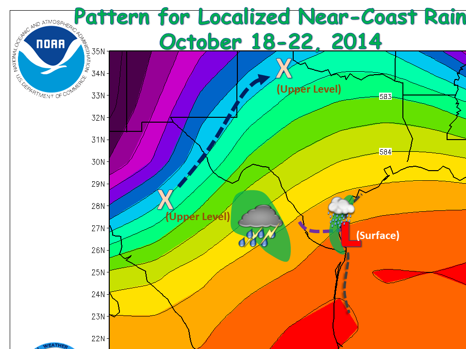 Mean steering pattern (500 millibar) across Texas and northern Mexico from October 18–22, 2014. Upper level disturbances moving across west Texas helped induce a persistent weak surface trough (red L and gray dashed lines) from the Texas Coastal Bend through Tamaulipas. On the 21st and perhaps into the 22nd, a weak shear axis (purple dashed line) drifted south into the Lower Rio Grande Valley, sparking additional rains. |
Brownsville and locations just north and northeast received the lion’s share of the rain through the period. On Saturday, October 18th, convergence of low level southerly flow along and just east of U.S. 77 (Interstate 69E) with easterly flow along the near the coast lifted warm, humid air into low–topped showers and thunderstorms. The precipitation began just before dawn and persisted through early afternoon; when finished, between 2 and nearly 4 inches had fallen between Brownsville and Rio Hondo (Cameron), likely continuing into southeast Willacy County. The on again, off again rain falling mainly in rural locations produced nuisance minor flooding, but ended up being more welcome than unwanted after the drier air earlier in the week began to turn grasses and brush brittle. After a cloudy break on the 19th, showers with moderate rainfall dotted the area from the King Ranch through the Hidalgo County ranchlands on the 20th; flooding rains formed along the Coastal Bend near Corpus Christi, at the edge of the aforementioned shear axis. The rains on the 20th were nothing unusual for Deep South Texas, but the arrival of the remnant shear axis on the 21st produced more robust rain bands, particularly across southern Kenedy and Willacy County that extended into northern Hidalgo County. Radar and observations suggested 2 to 3 inches fell in these bands, with other torrential pockets dropping ½ to 1 inch between Harlingen and McAllen. By sunset, a band of short lived but torrential rain snuck across the Rio Grande in southeast Cameron County and dropped one–third an inch in Brownsville. The October 21st evening rain may have set the stage for what happened during the early morning commute and school trip on the 22nd. A band of very heavy rain developed along the Rio Grande east of Brownsville, and spread across the city from the Sabal Palm Sanctuary through Southmost and into downtown between 630 and 830 AM. Soon after the torrents began, poor drainage and rainfall rates of 2 inches per hour overwhelmed many areas, with nuisance flooding (up to 2 feet)in in numerous locations and more life/property threatening flash flooding (3 feet or more, water into property) in some of the worst draining areas as well as locations where 3 inches fell in an hour or less. More than 3.5 inches may have fallen near downtown during the event, which matched closely with known flash flood areas (some shown in the photos above). 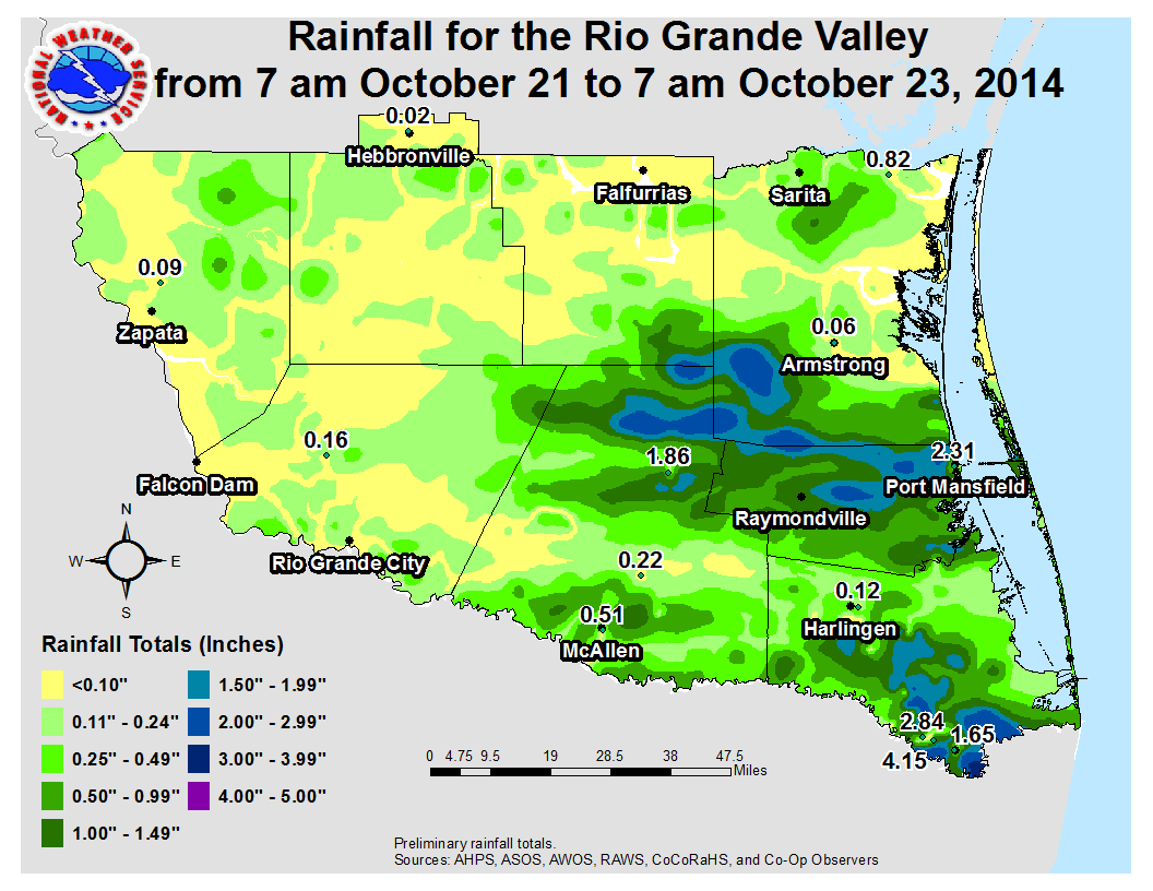 Measured and estimated rainfall from 7 AM October 21 through 7 AM October 23 for the Rio Grande Valley. Much of the rain near Brownsville fell betwee 630 and 830 AM on October 22. |
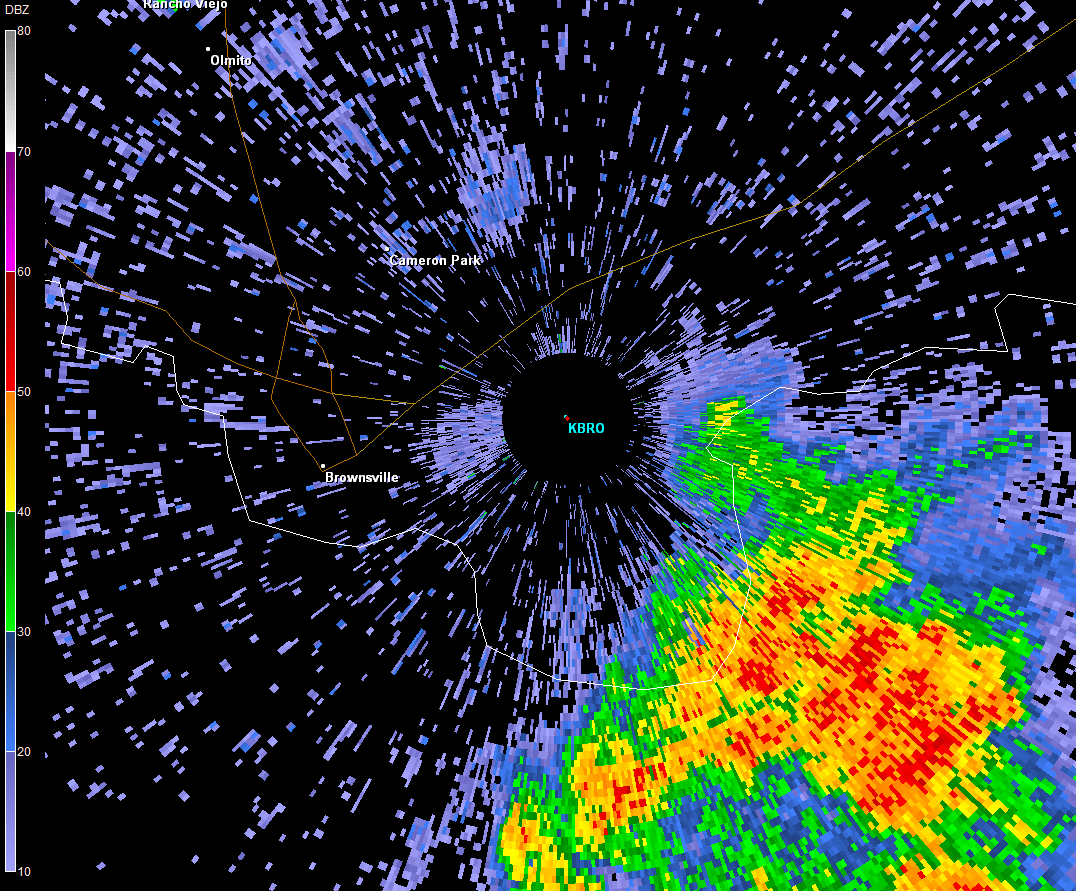 Brownsville radar reflectivity loop, at 1.5° elevation, from 627 through 824 AM October 22, 2014. 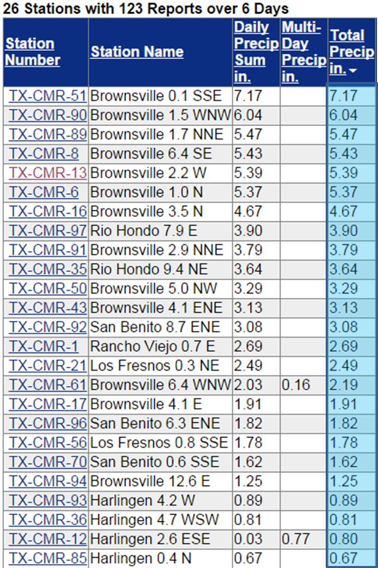 Rainfall in Cameron County, via the Community Collaborative Rain, Hail, and Snow network (CoCoRaHS), from roughly 7 AM October 17 through 7 AM October 23. Note the concentration of heaviest rain from Southmost Brownsville through Rio Hondo. Official observations (not shown) in the area for the period included Port Mansfield (Willacy, 3.85 inches), Brownsville/South Padre International Airport (3.07 inches), Harlingen/Valley International Airport (0.45 inches), Cameron County Airport near Bayview (1.07 inches), Port Mansfield and Harlingen/Cooperative (0.39 inches). |
|

