 Above: Photos taken across the Rio Grande Valley (U.S. and Mexico) and Ranchlands of flooding and wind damage from overnight May 11/12, 2015, and during the afternoon of May 15th. Thanks to NWS Brownsville/Rio Grande Valley Facebook followers and KRGV Channel 5 Weather Facebook Followers for providing most of the photos. |
|
| Enough, Already? Deluges Force Water Rescues in Starr, Hidalgo, and Brooks County May 11/12, May 15, 2015 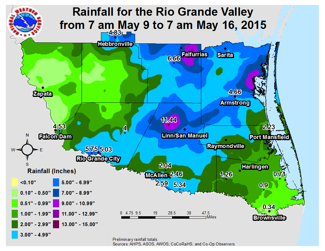 |
|
 0.5° Base Reflectivity radar loop from 8 PM May 11th through 1230 AM May 12th, showing "training" (cells moving over the same areas for a prolonged period of time) across Starr, northern Hidalgo, and Brooks County. May 11/12: One Wild Night for the Mid and Upper Valley Flooding rains resulted in at least a dozen water rescues in and near Rio Grande City, including the Las Lomas neighborhood and Garciasville, where some homes (above) had up to 3 feet of water inside them after a likely combination of freshwater (drainage) and arroyo flooding from an estimated/measured five to seven inches of rain in two to three hours. Portions of U.S. 83 in southeast Starr were temporarily closed due to 2 to 4 feet of standing water, mainly from Rio Grande City to near the Hidalgo County line, mainly after 1030 PM on the 11th. Higher rain totals, estimated by radar to be between 7 and 9 inches, likely flooded ranches and agricultural fields in northern Hidalgo county north of Farm to Market Road 1017. Along and near 1017, extending southeast to areas north and east of Edinburg, including Faysville and Monte Alto, poor drainage flooding resulted in water rescues that continued well into May 12th. The flooding was not isolated to rural areas of the Mid/Upper Valley. Torrential rains slid into the McAllen/Weslaco/Donna area, where nuisance flooding with water levels up to two feet was noted well after midnight when 2 to 3 inches of rain piled up. Significant flooding was first noted in Hebbronville when storms clustered just before sunset, with up to a foot of water in most areas, including some into at least one building, along with water rescues. Conditions worsened farther east in and near Falfurrias, where an estimated and measured 5 to 7 inches resulted in minor to moderate urban flooding, with several water rescues in one to two feet of water thorughout town just after sunset. High standing water, 1 to 1½ feet, continued through the night. Total rainfall for the week of May 9th through 15th, inclusive, was a mixed bag. Zapata County missed the balance of the rain, as did the populated beaches of Cameron County west through Port Isabel and Brownsville, which only received light, stratiform "debris" rainfall from the remnants of the May 11th/early may 12th Mid/Upper Valley slam. Elsewhere, well over six times the weekly average fell; in some areas, rainfall totals were more than the entire May through July average (6 to 9 inches)! 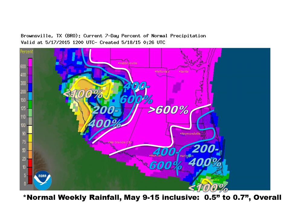 May 9th through 15th, 2015, percentage of average rainfall, based on 1981 to 2010 values, for the Rio Grande Valley/Deep South Texas. Lightning was also a significant hazard during the evening of May 11th and the wee hours of May 12th, with [get estimated strikes from streamer RT here] strikes during the peak of the activity (9 PM through 230 AM) especially in Starr, Hidalgo, and Brooks County. In Edinburg, the assistant Emergency Management Coordinator reported continuous lightning during the peak of the storm there (11 PM through 1 AM), as well as seven separate calls from residents who experienced strikes and, at a minimum, the "smell of smoke" inside their residents. At the peak of the storms, more than 21 thousand and perhaps up to 25 thousand residents in Starr, Hidalgo, and Cameron County were without electricity; outages were likely the result of the persistent cloud to ground lightning strikes in addition to local wind damage and flooding. |
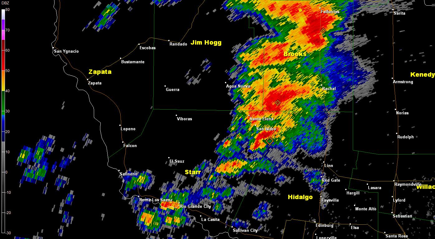
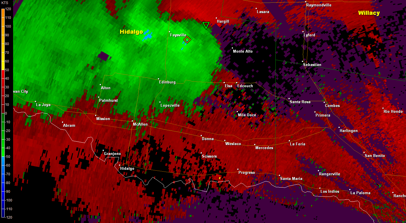 0.5° Base Velocity radar loop from Midnight through 2 AM, May 12th, showing nearly continuous damage potential winds (blue areas) that initially formed near Edinburg and re–formed, stronger, about an hour later (1 to 130 AM) from Elsa/Edcouch to La Villa, extending toward the Cameron/Hidalgo County line May 11/12: One Wild Night for the Mid and Upper Valley (continued) May 13 to 15: Round Two? Creek Flooding Hits Falfurrias; Another Slam for Hidalgo Co. While most of the downpours held across rural northern Hidalgo County, enough additional rainfall would fall near Edinburg to exacerbate flood concerns in Faysville, where pumping operations would be forced to continue well into the following week (week of May 18th). Boundaries from these storms and the squall line that slammed offshore between Corpus and Kingsville set the stage for slow moving storm clusters from northeast Hidalgo across the King Ranch (Kenedy County), where four to eight inches (estimated) fell. Along the southern edge of the heaviest rain, a radar–indicated circulation, perhaps a tornado, appeared in southwest Kenedy County (below). One last dump of rain caused nuisance urban flooding in Raymondville, where two or more inches fell between 430 and 530 PM on the 15th. Flooding rains on the 15th were not reserved for the U.S.; a small but potent cell may have been the cause of flash flooding in Reynosa (south of Pharr), where photos indicated up to 3 feet of flowing water (gallery, above). 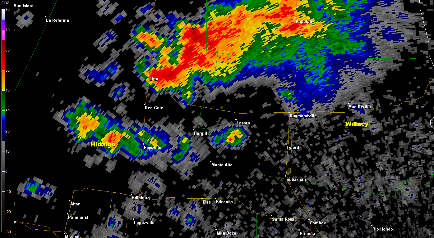 0.9° Base Reflectivity radar loop from 2 through 430 PM, May 15th, showing torrential rainfall developing across northern Hidalgo County and spreading into much of Kenedy County. Heavy rainfall would continue in Kenedy and northwest Willacy County through around 530 PM. 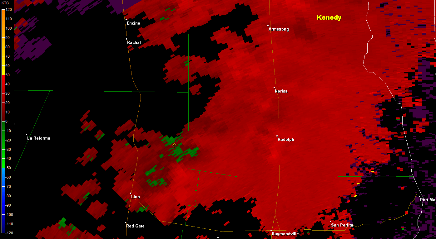 0.5° Base Velocity radar loop from 2 through 330 PM, May 15th, showing well defined circulation (red next to green, in a circular shape) moving steadily through southwest Kenedy County. There may have been a tornado on the ground, but thus far there have been no reports from this very rural area. |
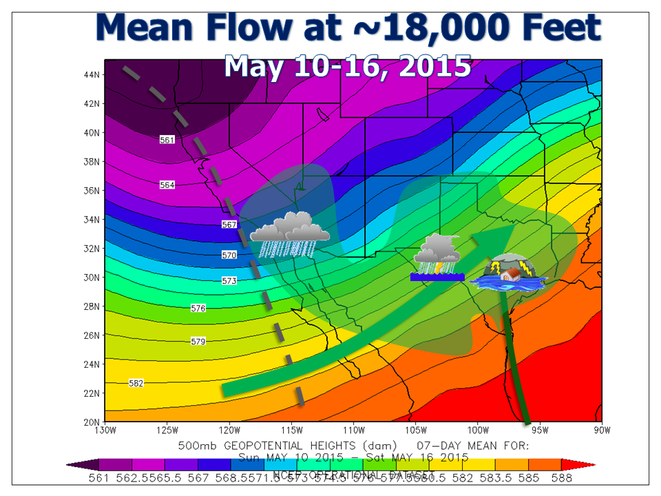 Mean steering pattern (~18,000 feet) across the southwest U.S. during the week of May 10 to 16, 2015. Note persistent southwest flow of deep tropical moisture from the very warm eastern tropical Pacific ocean (large green arrow) that combined with rich moisture from the southwest Gulf (thinner green arrow) to produce abundant rainfall in Texas, which killed off drought in many areas for the first time since 2010. 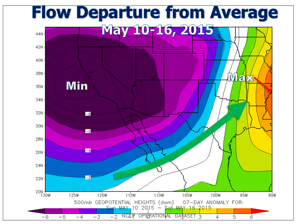 Anomalies (departures from average) of the steering pattern (~18,000 feet) across the southwest U.S. during the week of May 10 to 16, 2015. Higher values (i.e. high pressure ridge) are off the chart to the right; much lower values along/west of the southern California Coast ("Min"). One can visualize the anomalous flow from south to north of rich tropical air across Texas, which spawned widespread flooding from parts of the Valley all the way through north central Texas that week. |
|
PRELIMINARY LOCAL STORM REPORT...SUMMARY
NATIONAL WEATHER SERVICE BROWNSVILLE TX
850 PM CDT TUE MAY 12 2015

..TIME...   ...EVENT...      ...CITY LOCATION...     ...LAT.LON...
..DATE...   ....MAG....      ..COUNTY LOCATION..ST.. ...SOURCE....
            ..REMARKS..

0704 PM     FLASH FLOOD      HEBBRONVILLE            27.32N  98.69W
05/11/2015                   JIM HOGG           TX   LAW ENFORCEMENT

            JIM HOGG COUNTY SHERIFFS OFFICE REPORTS 6 INCHES TO 1
            FOOT OF WATER ON ALL ROADS IN HEBBRONVILLE. 2 WATER
            RESCUES FROM VEHICLES COMPLETED. WATER IN 1 BUILDING IN
            HEBBRONVILLE. SHERIFFS OFFICE ALSO REPORTS LOS OLMOS
            CREEK AT CAPACITY AND IN DANGER OF FLOWING OVER THE
            ROADWAY.

0730 PM     TSTM WND DMG     2 E FALFURRIAS          27.22N  98.12W
05/11/2015                   BROOKS             TX   LAW ENFORCEMENT

            POWER POLES BENT OVER ALONG COUNTY ROAD 229 AND HIGHWAY
            285.

0836 PM     FLASH FLOOD      FALFURRIAS              27.23N  98.15W
05/11/2015                   BROOKS             TX   LAW ENFORCEMENT

            BROOKS COUNTY SHERIFFS OFFICE REPORTS 1 FOOT OF WATER
            AT THE INTERSECTION OF CENTER STREET AND BENNETT STREET
            IN THE CITY OF FALFURRIAS.

0900 PM     FLASH FLOOD      FALFURRIAS              27.23N  98.15W
05/11/2015                   BROOKS             TX   LAW ENFORCEMENT

            BROOKS COUNTY SHERIFFS OFFFICE REPORTS 1 FOOT OF WATER
            IN ONE SPOT ON THE EXPRESSWAY. ALSO 1 FOOT OF WATER ONE
            QUARTER MILE SOUTH OF FM 1418 AND 1 FOOT OF WATER AT THE
            INTERSECTION OF 281 AND CEMETARY ROAD.

0930 PM     FLASH FLOOD      EL CENIZO COLONIA       26.41N  98.92W
05/11/2015                   STARR              TX   LAW ENFORCEMENT

            WATER ENTERING HOME ON CHAPOTITO ROAD 1 MILE NORTH OF
            LA ROSITA IN SOUTHERN STARR COUNTY.
0940 PM     FLASH FLOOD      FALFURRIAS              27.23N  98.15W
05/11/2015                   BROOKS             TX   LAW ENFORCEMENT

            BROOKS COUNTY SHERIFFS OFFICE REPORTS WOMAN WITH 2
            CHILDREN RESCUED FROM VEHICLE FLOODED BY 2 FEET OF WATER
            ON BUSINESS 281 IN FALFURRIAS. ALSO 1 PERSON RESCUED
            FROM VEHICLE FLOODED WITH 1 FOOT OF WATER AT
            INTERSECTION OF ADAMS AND TERELL STREET. ALSO WOMAN AND
            DOG CURRENTLY BEING RESCUED FROM FLOODED VEHICLE 2 MILES
            SOUTH OF FALFURRIAS.

0955 PM     FLASH FLOOD      RIO GRANDE CITY         26.38N  98.83W
05/11/2015                   STARR              TX   LAW ENFORCEMENT

            STARR COUNTY SHERIFFS OFFICE REPORTS 6 INCHES OF WATER
            ON CROCKETT STREET IN RIO GRANDE CITY. ALSO RESIDENCE ON
            CHAPOTITO ROAD HAS 5 TO 6 INCHES OF WATER INSIDE THE
            BUILDING.

1000 PM     HAIL             1 E VILLAREALES         26.37N  98.86W
05/11/2015  E1.00 INCH       STARR              TX   LAW ENFORCEMENT

            SHERIFF OFFICE REPORTED QUARTER SIZE HAIL ON THE WEST
            SIDE OF RIO GRANDE CITY.

1025 PM     HAIL             RIO GRANDE CITY         26.38N  98.83W
05/11/2015  E1.00 INCH       STARR              TX   LAW ENFORCEMENT

            STARR COUNTY SHERIFFS OFFICE REPORTS QUARTER SIZE HAIL
            AT THE INTERSECTION OF FM 3167 AND EISENHOWER ROAD.

1026 PM     FLASH FLOOD      RIO GRANDE CITY         26.38N  98.83W
05/11/2015                   STARR              TX   LAW ENFORCEMENT

            STARR COUNTY SHERIFFS OFFICE REPORTS JUVENILE DETENTION
            CENTER AT INTERSECTION OF BRITTON AVENUE AND HIGHWAY 83
            HAS 6 INCHES OF WATER IN BUILDING.

1028 PM     FLASH FLOOD      RIO GRANDE CITY         26.38N  98.83W
05/11/2015                   STARR              TX   LAW ENFORCEMENT

            STARR COUNTY SHERIFFS OFFICE REPORTS 3 FEET OF WATER ON
            HIGHWAY 83 NEAR ALVAREZ ROAD.

1042 PM     FLASH FLOOD      RIO GRANDE CITY         26.38N  98.83W
05/11/2015                   STARR              TX   LAW ENFORCEMENT

            STARR COUNTY SHERIFFS OFFICE REPORTS 6 TO 8 INCHES OF
            WATER ON HIGHWAY 83 IN RIO GRANDE CITY IN FRONT OF
            WALMART.

1100 PM     FLASH FLOOD      SAN MANUEL              26.57N  98.12W
05/11/2015                   HIDALGO            TX   EMERGENCY MNGR

EM FROM HIDALGO COUNTY REPORTED WATER WAS ENTERING THE
            FIRE STATION IN SAN MANUEL.

1109 PM     FLASH FLOOD      LA CASITA               26.32N  98.72W
05/11/2015                   STARR              TX   FIRE DEPT/RESCUE

            LA CASITA FIRE DEPARTMENT REPORTS WIDESPREAD 3 TO 4
            FEET OF WATER ON HIGHWAY 83 BETWEEN LA CASITA AND RIO
            GRANDE CITY. WATER UP TO THE ENGINE ON FIRE DEPARTMENT
            VEHICLE.

1115 PM     FLASH FLOOD      1 S LAS LOMAS           26.36N  98.78W
05/11/2015                   STARR              TX   LAW ENFORCEMENT

            ROAD WAS REPORTED CLOSED AT THE INTERSECTION OF US 83
            AND EMBASSY STREET IN THE LAS LOMAS AREA.

1115 PM     FLASH FLOOD      1 S LAS LOMAS           26.36N  98.78W
05/11/2015                   STARR              TX   LAW ENFORCEMENT

            CAR WAS REPORTED FLOATING IN 3 TO 4 FEET OF MOVING
            WATER IN THE LAS LOMAS AREA. WATER RESCUE WAS IN
            PROGRESS.

1115 PM     FLASH FLOOD      1 W LAS LOMAS           26.36N  98.79W
05/11/2015                   STARR              TX   LAW ENFORCEMENT

            3 FEET OF WATER WAS REPORTED IN FRONT OF WALMART IN THE
            LAS LOMAS AREA ALONG HIGHWAY 83.

1150 PM     TSTM WND DMG     ALTO BONITO             26.31N  98.64W
05/11/2015                   STARR              TX   LAW ENFORCEMENT

            STARR COUNTY SHERIFFS OFFICE REPORTS SHINGLES BLOWN OFF
            ROOF AND DAMAGE TO WALLS OF STRUCTURE IN COLONIA.

1205 AM     TSTM WND DMG     LA BLANCA               26.29N  98.04W
05/12/2015                   HIDALGO            TX   PUBLIC

            FACEBOOK USER REPORTS OVER 60 ACRES OF CORN LEVELED BY
            STRAIGHT-LINE WINDS AT THE CORNER OF FM 493 AND FM 2812.
            EVENT TIME ESTIMATED FROM RADAR IMAGERY.

1225 AM     FLASH FLOOD      2 E RIO GRANDE CITY     26.38N  98.79W
05/12/2015                   STARR              TX   LAW ENFORCEMENT

            FAMILY RESCUED FROM HOME AMID AROUND 4 FEET OF RUSHING
            WATER FLOWING DOWN THE STREET EN ROUTE TO THE LOS OLMOS
            CREEK.

1230 AM     FLASH FLOOD      3 E RIO GRANDE CITY     26.38N  98.78W
05/12/2015                   STARR              TX   PUBLIC

SEVERAL SOCIAL MEDIA POSTS WITH WATER 3 TO 6 INCHES
            DEEP IN HOMES IN SOUTHEASTERN STARR COUNTY.

1243 AM     FLASH FLOOD      MCCOOK                  26.48N  98.38W
05/12/2015                   HIDALGO            TX   DEPT OF HIGHWAYS

            DEPARTMENT OF PUBLIC SAFETY REPORTS 8 INCHES OF WATER
            ON MONTE CRISTO ROAD AND 4 INCHES OF WATER ON FM 681 IN
            THE VICINITY OF MCCOOK.

1251 AM     FLASH FLOOD      RIO GRANDE CITY         26.38N  98.83W
05/12/2015                   STARR              TX   LAW ENFORCEMENT

            STARR COUNTY SHERIFFS OFFICE REPORTS 6 NEW WATER
            RESCUES IN THE LAS LOMAS SUBDIVISION. WATER WAS 1 FOOT
            DEEP IN ONE OF THE HOUSES.

0110 AM     TSTM WND DMG     PROGRESO                26.10N  97.96W
05/12/2015                   HIDALGO            TX   LAW ENFORCEMENT

            PROGRESO POLICE DEPARTMENT REPORTS TREE BLOWN DOWN ONTO
            VEHICLE AT RESIDENCE ON WATTS STREET IN PROGRESO.

0120 AM     FLASH FLOOD      EDINBURG                26.30N  98.16W
05/12/2015                   HIDALGO            TX   PUBLIC

            SEVERAL SOCIAL MEDIA POSTS AND MEDIA REPORTS SHOW 6 TO
            10 INCHES OF WATER IN STREETS AND PARKING LOTS IN
            EDINBURG MCALLEN...AND VICINITY.

0120 AM     TSTM WND DMG     1 N LA VILLA            26.31N  97.93W
05/12/2015                   HIDALGO            TX   EMERGENCY MNGR

            SOCIAL MEDIA REPORTS AND HIDALGO COUNTY EMERGENCY
            MANAGER CONFIRMS MULTIPLE METAL WALLS OF PREFABRICATED
            BUILDING PEELED BACK AND BLOWN OUT 1 MILE NORTH OF LA
            VILLA AT THE INTERSECTION OF 17 1/2 ROAD AND FM 491.
            EVENT TIME ESTIMATED FROM RADAR IMAGERY.

0120 AM     TSTM WND DMG     LA VILLA                26.30N  97.93W
05/12/2015                   HIDALGO            TX   EMERGENCY MNGR

            HIDALGO COUNTY EMERGENCY MANAGER REPORTS METAL FENCE
            BLOWN DOWN AND METAL CANOPIES FOR RECREATIONAL VEHICLES
            BLOWN OFF AT NATURE RESORT RV PARK AT 10201 EAST MONTE
            CRISTO ROAD IN LA VILLA. EVENT TIME ESTIMATED FROM RADAR
            IMAGERY.

0120 AM     TSTM WND DMG     LA VILLA                26.30N  97.93W
05/12/2015                   HIDALGO            TX   EMERGENCY MNGR

            HIDALGO COUNTY EMERGENCY MANAGER REPORTS WIDESPREAD
            DAMAGE IN LA VILLA. SHINGLED ROOFS PEELED BACK. LARGE
            METAL CANOPY FOR RV BENT. MULTIPLE TREES DOWN. SMALL
            WOODEN AND METAL STORAGE BUILDINGS EITHER TOPPLED OVER
            OR MOVED OFF FOUNDATIONS. MULTIPLE CEDAR FENCES BLOWN
            OVER. MOBILE HOME SHIFTED OFF FOUNDATION BLOCKS.
            TRAMPOLINE BLOWN INTO THE MIDDLE OF COTTON FIELD. PRESS
            BOX AT LA VILLA HIGH SCHOOL DESTROYED. 6 UTILITY POLES
            DOWN EAST OF THE CITY. EVENT TIME ESTIMATED FROM RADAR
            IMAGERY.

0130 AM     TSTM WND DMG     EDCOUCH                 26.29N  97.96W
05/12/2015                   HIDALGO            TX   LAW ENFORCEMENT

            EDCOUCH POLICE DEPARTMENT REPORTS 4 TO 5 TREES BLOWN
            DOWN AT THE INTERSECTION OF WEST 107 AND SOUTH
            INDUSTRIAL.

0130 AM     FLASH FLOOD      MERCEDES                26.15N  97.92W
05/12/2015                   HIDALGO            TX   LAW ENFORCEMENT

            MERCEDES POLICE DEPARTMENT REPORTS 6 TO 8 INCHES OF
            WATER AT INTERSECTION OF BUSINESS 83 AND INDIANA AND
            BUSINESS 83 AND WASHINGTON.

0140 AM     FLASH FLOOD      WESLACO                 26.16N  97.98W
05/12/2015                   HIDALGO            TX   LAW ENFORCEMENT

            WESLACO POLICE DEPARTMENT REPORTS 1 FOOT OF WATER ON
            AIRPORT ROAD FROM BUSINESS 83 TO 8TH STREET. ALSO 1.5 TO
            2 FEET OF WATER AT THE INTERSECTION OF WESTGATE AND
            PIKE.

0140 AM     TSTM WND DMG     ELSA                    26.30N  97.99W
05/12/2015                   HIDALGO            TX   LAW ENFORCEMENT

            ELSA POLICE DEPARTMENT REPORTS TREE BLOWN DOWN BY
            THUNDERSTORM WINDS ON NORTH FANNIN IN ELSA.

0140 AM     TSTM WND DMG     LA FERIA                26.16N  97.82W
05/12/2015                   CAMERON            TX   LAW ENFORCEMENT

            LA FERIA POLICE DEPARTMENT REPORTS UTILITY POLE LEANING
            HEAVILY ON PALM TREE DUE TO THUNDERSTORM WIND GUSTS AT
            INTERSECTION OF THE FRONTAGE ROAD AND SOLIS ROAD. ALSO
            TREE BLOWN DOWN IN ALLEY BETWEEN SEVENTH STREET AND
            EIGHTH STREET. EVENT TIME ESTIMATED FROM RADAR IMAGERY.

0140 AM     TSTM WND DMG     SANTA ROSA              26.25N  97.83W
05/12/2015                   CAMERON            TX   PUBLIC

            EMPLOYEE AT SUGAR MILL IN SANTA ROSA REPORTS UTILITY
            POLE LEANING HEAVILY ON FM 1425 DUE TO THUNDERSTORM
            WINDS. EVENT TIME ESTIMATED FROM RADAR IMAGERY.

0155 AM     TSTM WND DMG     MERCEDES                26.15N  97.92W
05/12/2015                   HIDALGO            TX   LAW ENFORCEMENT

            MERCEDES POLICE DEPARTMENT REPORTS WINDOW BLOWN OUT AT
            OUTLET MALL. ALSO PALM TREE BLOWN DOWN ON DAWSON STREET.

0322 AM     FLASH FLOOD      FALFURRIAS              27.23N  98.15W
05/12/2015                   BROOKS             TX   LAW ENFORCEMENT

            WATER 12 TO 18 INCHES DEEP ON MANY ROADS IN
            FALFURRIAS...INCLUDING HIGHWAY 281. WATER UP TO THE
            POINT RESIDENTS CANT GET OUT OF THEIR HOMES.
|
|

