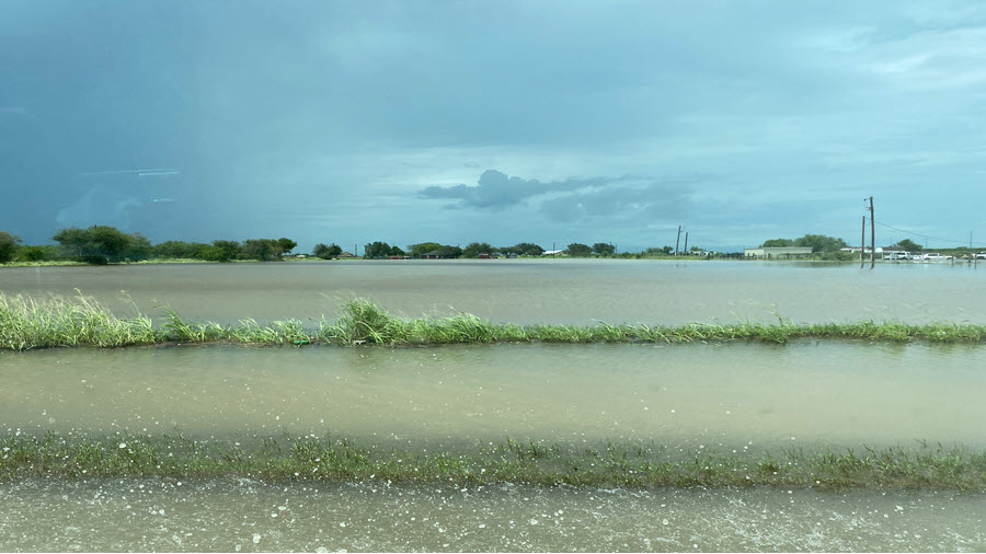
Three times was not the charm for the Rio Grande Valley in July, 2020. For the third summer in a row, significant to locally devastating flooding inundated parts of the Rio Grande Valley...in some cases in the same neighborhoods with similar water levels. In 2018, the culprit was a elongated tropical wave that brought abundant moisture from the western Caribbean, eastern tropical Pacific, and southwest Gulf for days. In 2019, the combination of outflow boundaries from southeast Texas, upper level energy in northeast Mexico, and a highly unstable atmosphere did the deed. In 2020? It was an early-season hurricane.
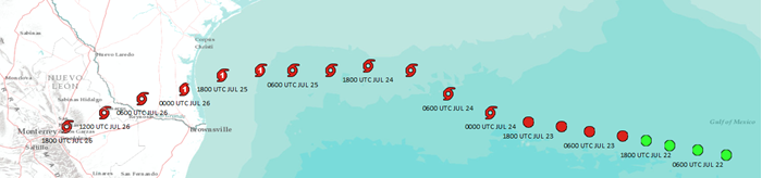
Hurricane Hanna, the 2020 Atlantic season's first Hurricane, made landfall along the unpopulated Padre Island National Seashore on the mid-Kenedy County coastline at around 5 PM Central Time Saturday, July 25th, carrying sustained 90 mph winds with gusts over 100 mph in a small portion of the inner eye wall. The hurricane spun slowly but steadily into southern Kenedy and northern Hidalgo County through just after midnight on the 26th, then through Starr County as a Tropical Storm before moving into Tamaulipas before daybreak and eventually near Monterrey, Nuevo Leon, by noon before dissipating during the evening of the 26th.
Hanna marked the first direct landfall and track of a hurricane across Deep South Texas and the Rio Grande Valley for the first time since Hurricane Dolly in 2008, which coincidentally crossed the Valley just a few days earlier (July 23-24, 2008). The cyclone began as a disorganized area of showers and thunderstorms associated with a tropical wave near Hispañola on July 19th. Over the next three days, the wave struggled to develop, fighting off dry air and a bit of wind shear as it slowly edge westward. By July 23, however, the wave moved into an area of low wind shear and higher "fuel" in the form of very warm sea surface temperatures. Soon after, Tropical Depression 8 formed, and by late evening on the 23rd, Hanna was born as a Tropical Storm over the west-central Gulf, about 225 miles south of the Louisiana coast. Hanna steadily strengthened on the 24th while on a westward heading, and became Hurricane Hanna at daybreak on the 25th, just 90 miles east of Port Mansfield.
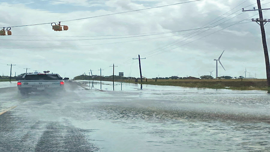
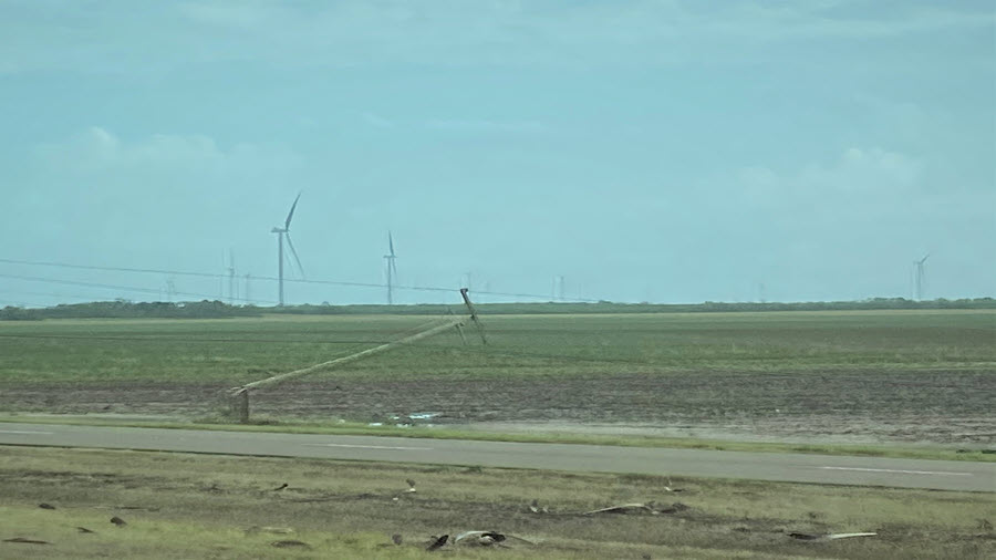
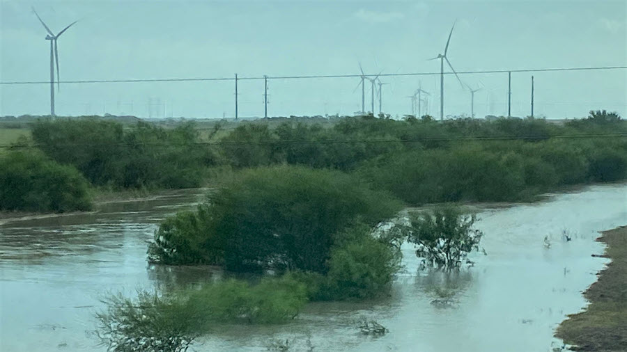
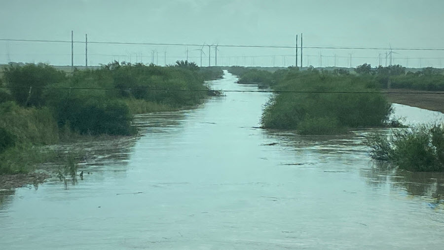
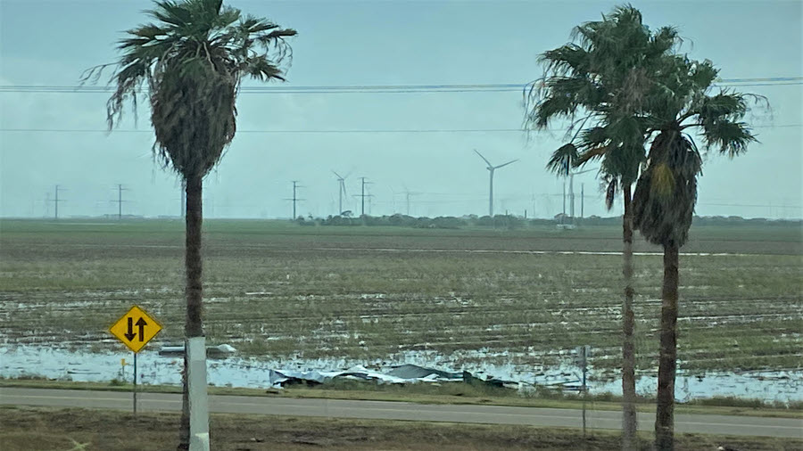
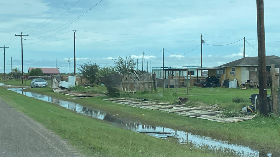
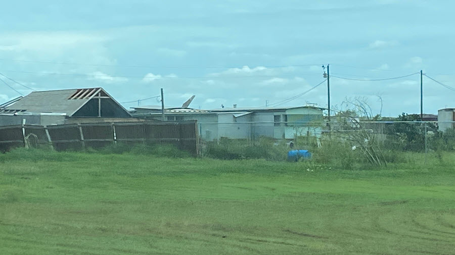
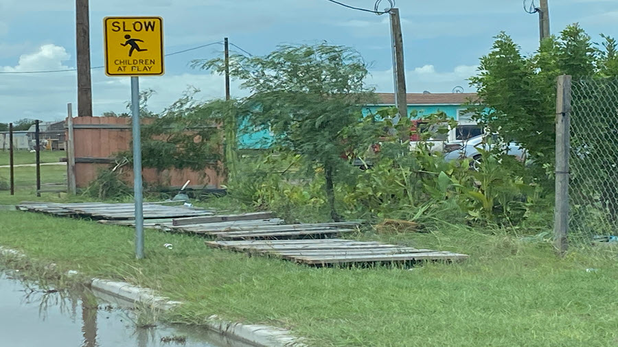
Following the passage of the inner eye wall, broad feeder bands of torrential rains and gusty tropical storm force winds continued through the mid to late morning hours of July 26th, slowly migrating from east to west across the populated Rio Grande Valley. Additional feeder bands redeveloped in unstable air Monday afternoon and evening in western Cameron and eastern Hidalgo County, exacerbating the ongoing flood conditions there.
Summary of Impacts
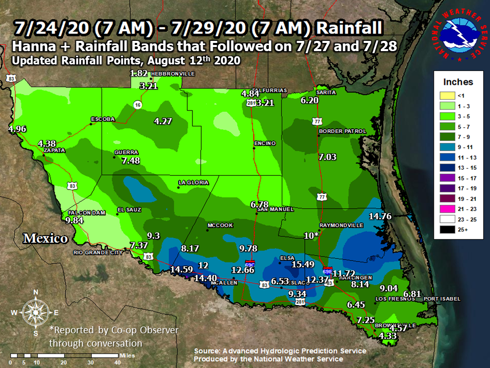
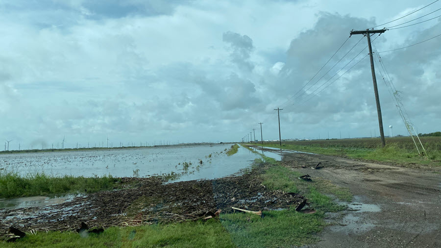
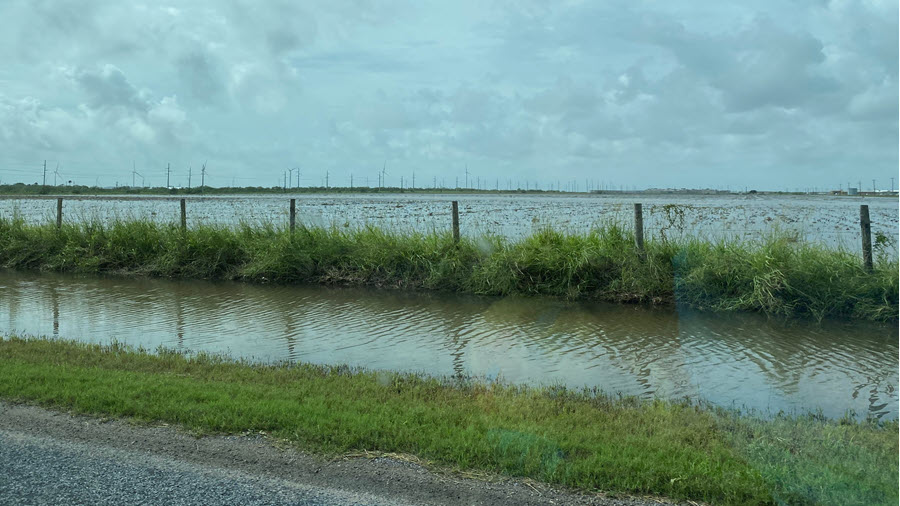
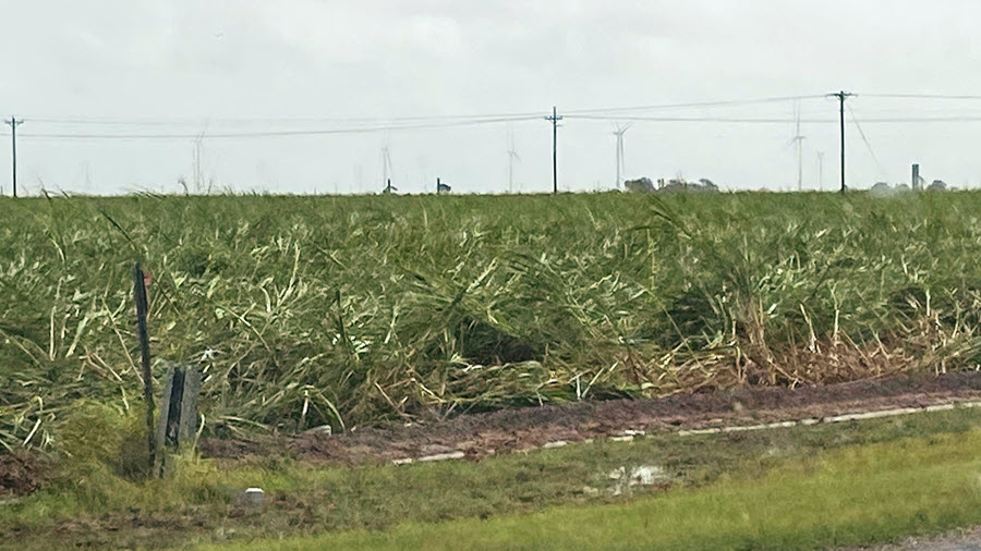
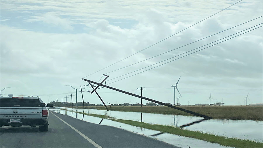
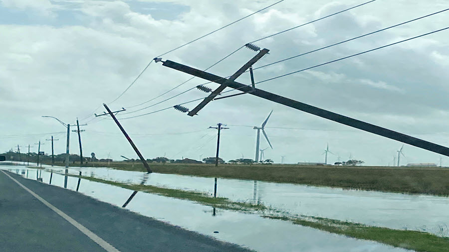
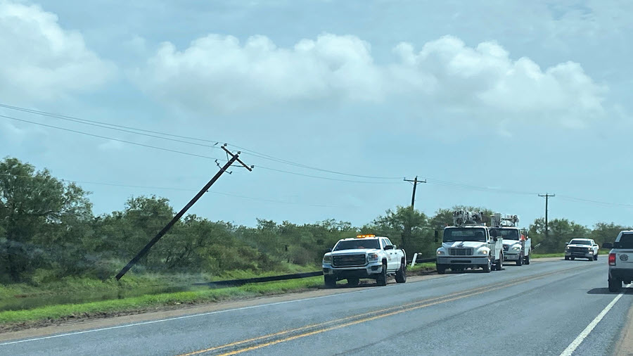
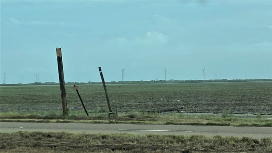
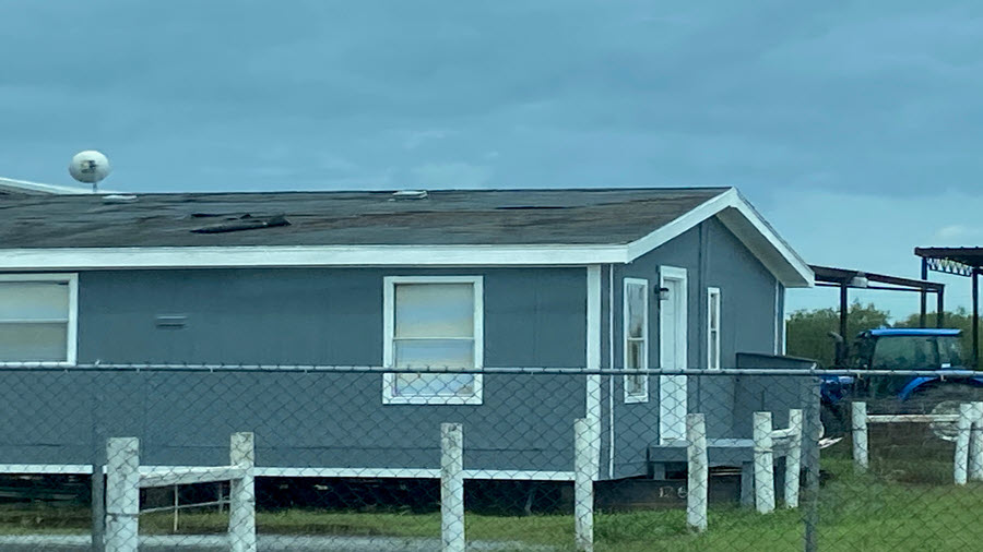
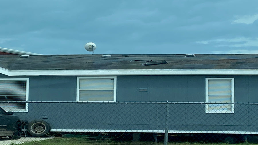
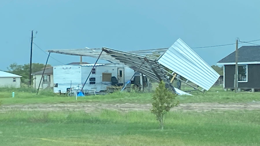
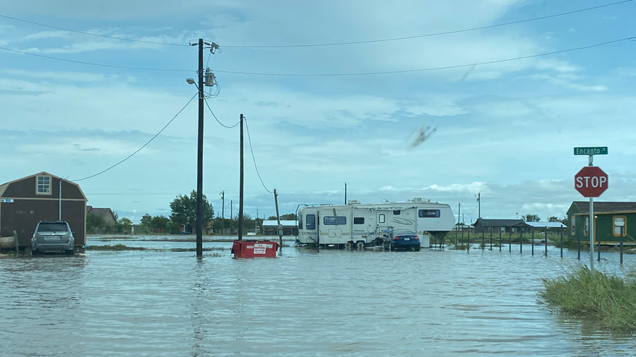
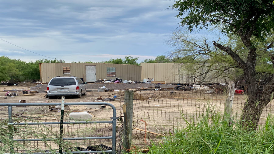
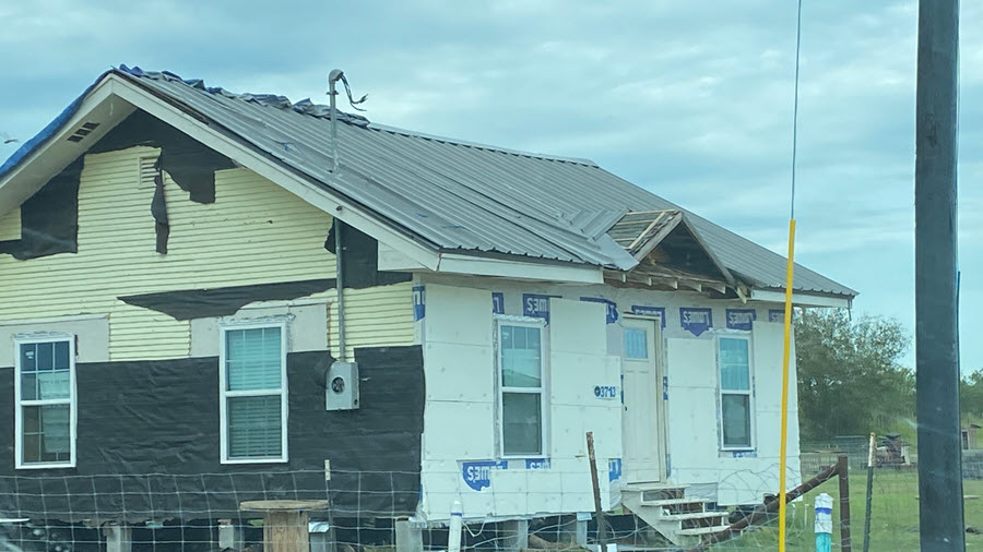
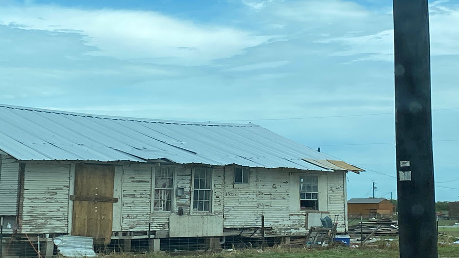
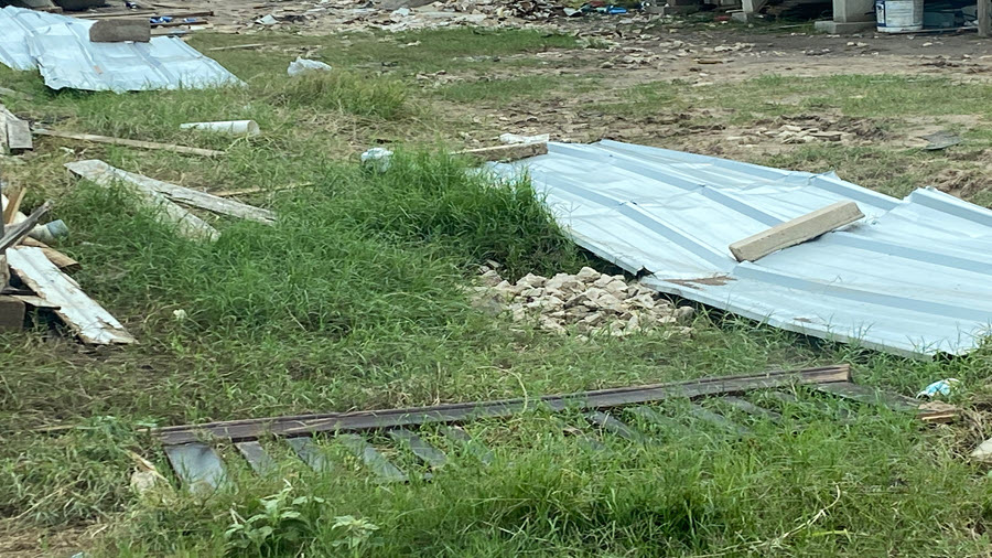
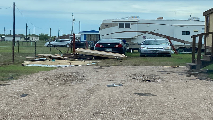
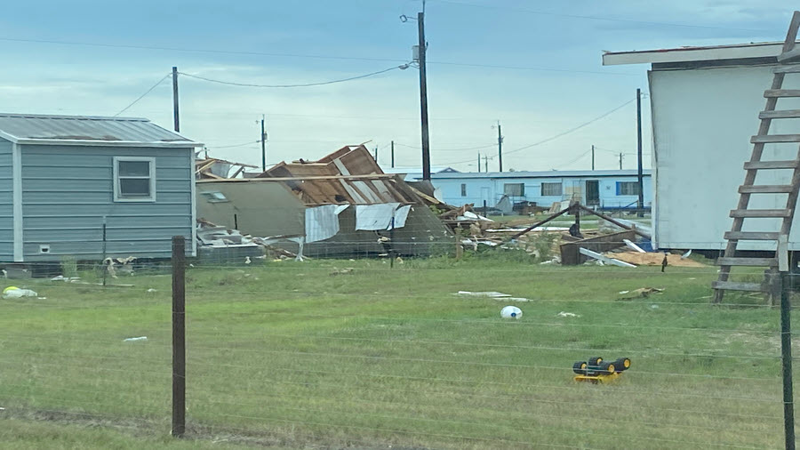
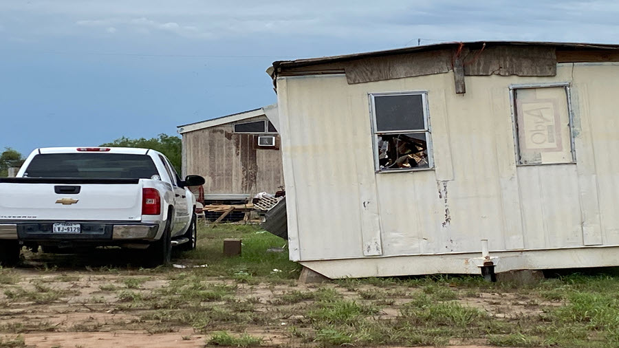
Throughout Hanna's life cycle, the most rain and wind activity was in the southern semicircle. Other than storm surge flooding, which peaked just north of Baffin Bay on the Kleberg and Nueces County coast near Corpus Christi, Hanna's memory for the Rio Grande Valley will be flooding rainfall, power outages, and an array of damage to poorly constructed buildings, from minor roof damage to complete demolition. The rainfall map (at right) for Hanna and two days of remnant squalls, was similar to both Hurricane Dolly and the Great June Flood of 2018. Review the tabs at the top of this page for details on rainfall, wind speeds, river/stream flows, tidal overwash, and even a small tornado that brushed by our office on the east side of Brownsville early on the 26th. Below is the "Tale of the Tape" from Hurricane Hanna.
When the damage and economic loss is counted to infrastructure and agriculture combined, it is likely that Hanna cost at least one billion dollars across the Rio Grande Valley and the Deep S. Texas ranch country. Disaster declarations were in effect to collect the data, and this site will be updated with those estimates between August and October 2020 and beyond.
| Location | County | Rainfall | Valid Time Period |
| Santa Rosa Coop | Cameron/Hidalgo Line | 15.49 | |
| Port Mansfield Coop | Willacy | 14.80 | |
| Port Mansfield 1.1 SE COCORAHS | Willacy | 14.76 | |
| Sullivan City 3.1 S HADS | Hidalgo | 14.59 | 72 hr Total as of 2 AM CDT 7/28/2020 |
| Mission 3.5 NW COCORAHS | Hidalgo | 14.40 | |
| La Joya 0.6 W COCORAHS | Hidalgo | 13.92 | |
| McAllen 2.4 NE COCORAHS | Hidalgo | 12.66 | |
| Harlingen 6.2 WSW COCORAHS | Cameron | 12.37 | |
| Mission 1 N COCORAHS | Hidalgo | 12.25 | |
| McAllen 3.5 N COCORAHS | Hidalgo | 12.03 | |
| Mission 1.9 ENE COCORAHS | Hidalgo | 12.00 | |
| La Joya LJAT2 | Hidalgo | 11.85 | |
| Harlingen Cooperative | Cameron | 11.72 | |
| Palmview 1.9 NW COCORAHS | Hidalgo | 11.65 | 48 hr Total as of 8 AM CDT 7/27/2020 |
| Harlingen 4.4 W COCORAHS | Cameron | 11.61 | |
| Harlingen 4 W COCORAHS | Cameron | 11.09 | |
| Texas Agriscience Mesonet 7 SW Lyford | Hidalgo | 10.98 | |
| McAllen 1.7 SSE COCORAHS | Hidalgo | 10.66 | |
| Mission 10 N COCORAHS | Hidalgo | 10.65 | |
| McAllen 2.7 NNE COCORAHS | Hidalgo | 10.55 | |
| Falcon Lake RAWS | Starr | 9.84 | 72 hr Total as of 2 AM CDT 7/28/2020 |
| Edinburg 2 N | Hidalgo | 9.78 | |
| Harlingen 0.4 N | Cameron | 9.70 | |
| Mission 4 WSW COCORAHS | Hidalgo | 9.50 | |
| Mercedes 1.9 SW COCORAHS | Hidalgo | 9.34 | |
| Rio Grande City 17.7 NE COCORAHS | Starr | 9.30 | |
| Los Fresnos 2.1 NNE COCORAHS | Cameron | 9.09 | |
| San Benito 6.3 ENE COCORAHS | Cameron | 8.74 | |
| Santa Ana NWR RAWS | Hidalgo | 8.68 | 72 hr Total as of 2 AM CDT 7/28/2020 |
| Brownsville 12.6 E COCORAHS | Cameron | 8.65 | |
| Harlingen 1.1 NE COCORAHS | Cameron | 8.52 | |
| McAllen Miller Intl | Hidalgo | 8.30 | |
| McAllen 1.8 SW COOP | Hidalgo | 8.23 | |
| La Joya 11.1 N COCORAHS | Hidalgo | 8.17 | |
| Los Fresnos 0.3 NE COCORAHS | Cameron | 7.90 | |
| Brownsville 4 N | Cameron | 7.49 | |
| Hebbronville 32.3 SSW COCORAHS | Jim Hogg | 7.48 | |
| Rio Grande City 3.5 ENE COCORAHS | Starr | 7.37 | |
| Brownsville 1.5 WNW | Cameron | 7.25 | |
| Brownsville 2.2 W COCORAHS | Cameron | 7.16 | |
| Armstrong 4SE | Kenedy | 7.03 | |
| Laguna Vista 0.3 N COCORAHS | Cameron | 6.81 | |
| Linn-San Manuel RAWS | Hidalgo | 6.78 | 72 hr Total as of 2 AM CDT 7/28/2020 |
| Rancho Viejo 0.7 E COCORAHS | Cameron | 6.54 | |
| Weslaco Midvalley AWOS | Hidalgo | 6.53 | |
| Brownsville 2.8 N COCORAHS | Cameron | 6.46 | |
| Sarita Fire Station | Kenedy | 6.20 | |
| Hebbronville 21 SSW COCORAHS | Jim Hogg | 5.85 | |
| Hebbronville 32 S COCORAHS | Jim Hogg | 5.84 | |
| Brownsville 0.1 SSE COCORAHS | Cameron | 5.69 | |
| Brownsville 7 NW COCORAHS | Cameron | 5.68 | |
| Brownsville 6.4 SE COCORAHS | Cameron | 5.30 | |
| Brownsville 0.4 WSW | Cameron | 5.25 | |
| San Manuel SMLT2 | Hidalgo | 5.19 | |
| Brownsville 1.7 NNE COCORAHS | Cameron | 5.15 | |
| Brownsville 2 ESE COCORAHS | Cameron | 5.02 | |
| Brownsville 4 ENE COCORAHS | Cameron | 5.00 | |
| San Ygnacio 2.3 SE COCORAHS | Zapata | 4.96 | |
| Falfurrias 4 W Coop | Brooks | 4.84 | |
| San Benito 0.9 SSE COCORAHS | Cameron | 4.83 | |
| La Parra (6 E Sarita) | Kenedy | 4.77 | |
| Laguna Vista 1.2 WNW COCORAHS | Cameron | 4.74 | |
| Brownsville WFO | Cameron | 4.57 | |
| Brownsville 6.4 WNW COCORAHS | Cameron | 4.56 | |
| Falfurrias 9 SSW COCORAHS | Jim Hogg | 4.47 | |
| Hebbronville 22.1 SSW COCORAHS | Jim Hogg | 4.41 | |
| Zapata AWOS | Zapata | 4.38 | |
| Falcon Dam 2.2 W HADS | Starr | 4.37 | 72 hr total 11:45 PM CDT 7/27/2020 |
| Brownsville Intl | Cameron | 4.33 | |
| Hebbronville 15 SSE COCORAHS | Jim Hogg | 4.27 | |
| Hebbronville 0.7 ENE COCORAHS | Jim Hogg | 3.36 | |
| Hebbronville 4.3 S COCORAHS | Jim Hogg | 3.21 | |
| Falfurrias AWOS | Brooks | 3.21 | |
| Brownsville 4 NW COCORAHS | Cameron | 2.71 | |
| Port Isabel Cooperative | Cameron | 2.67 | |
| Rio Grande City Cooperative | Starr | 2.65 | |
| Hebbronville RAWS | Jim Hogg | 1.82 | 72 hr Total as of 2 AM CDT 7/28/2020 |
| Hebbronville AWOS | Jim Hogg | 1.18 | 72 hr Total as of 2 AM CDT 7/28/2020 |
Key:
Rainfall measured in inches.
Los Fresnos 0.3 NE = 0.3 miles northeast of Hebbronville.  E=East, S=South, W=West, N=North, etc.
ASOS=Automated Surface Observing System (NWS monitored)
AWOS=Automated Weather Observing System (FAA monitored)
AWS=Automated Weather Source (WeatherBug) Observing System
COCORAHS=COmmunity COllaborative RAin, Hail, and Snow Network
COOP=NWS Cooperative Observing Network
CWOP=Citizens Weather Observing Program
HADS=Hydrometeorological Automated Data System
RAWS=Remote Automated Weather System
| Location | County | Speed | Time of Occurrence | ||||
| Rincon Del San Jose, TX (Marine Station) | Kenedy | 103 | 0206 PM 07/25 | ||||
| Port Mansfield 53 ENE (Buoy 42020) | Gulf of America | 87 | 0220 PM 07/25 | ||||
| Texas Agriscience 7 SW Lyford | Hidalgo | 80 | 1105 PM 07/25 | ||||
| Armstrong Ranch (DTN) | Kenedy | 64 | 1000 PM 07/25 | ||||
| Rancho Las Comitas (La Gloria 6.0 NW - TWDB) | Starr | 64 | 0315 AM 07/26 | ||||
| Harlingen | Cameron | 63 | 0612 PM 07/25 | ||||
| Laguna Vista 11 N | Cameron | 62 | 0600 PM 07/25 | ||||
| Linn-San Manuel | Hidalgo | 61 | 0946 PM 07/25 | ||||
| McAllen | Hidalgo | 60 | 1028 PM 07/25 | ||||
| Weslaco Midvalley | Hidalgo | 59 | 0935 PM 07/25 | ||||
| South Padre (BZST2 Marine Station) | Cameron | 58 | 0355 PM 07/25 | ||||
| SPIW Park (Marine Station) | Cameron | 55 | 0427 PM 07/25 | ||||
| Port Isabel | Cameron | 55 | 0322 PM 07/25 | ||||
| Laguna Vista | Cameron | 55 | 0253 PM 07/25 | ||||
| Laguna Atascosa | Cameron | 55 | 0353 AM 07/26 | ||||
| Edinburg Intl | Hidalgo | 54 | 0615 PM 07/25 | ||||
| South Padre Island C.G. Station | Cameron | 53 | 0436 PM 07/25 | ||||
| Falfurrias | Brooks | 53 | 0815 PM 07/25 | ||||
| Falcon Lake | Starr | 52 | 0211 AM 07/26 | ||||
| Encino 11.8 SW (DTN) | Brooks | 49 | 1215 AM 07/26 | ||||
| Brownsville | Cameron | 48 | 0347 AM 07/26 | ||||
| South Padre Island 42 ENE (Buoy 42045) | Gulf of America | 45 | 0600 PM 07/25 | ||||
| Hebbronville | Jim Hogg | 44 | 0646 AM 07/26 | ||||
| Encino 10.8 NW (DTN) | Brooks | 42 | 1000 PM 07/25 | ||||
| Zapata | Zapata | 41 | 0940 AM 07/26 | ||||
| Los Fresnos | Cameron | 41 | 0446 PM 07/25 | ||||
| Santa Ana NWR | Hidalgo | 38 | 1045 PM 07/25 | ||||
| 1 N South Padre Island (Marine Station) | Cameron | 36 | 0425 PM 07/25 | ||||
| Weslaco 1.5 E (SCAN) | Hidalgo | 29 | 1100 PM 07/25 | ||||
| La Feria | Cameron | 29 | 1249 PM 07/25 | ||||
| Mission | Hidalgo | 27 | 0649 PM 07/25 | ||||
| La Joya | Hidalgo | 21 | 0100 PM 07/25 | ||||
| Edinburg 4 W | Hidalgo | 20 | 0305 PM 07/25 |
PRELIMINARY LOCAL STORM REPORT...SUMMARY
NATIONAL WEATHER SERVICE BROWNSVILLE TX
653 PM CDT SUN JUL 26 2020
..TIME... ...EVENT... ...CITY LOCATION... ...LAT.LON...
..DATE... ....MAG.... ..COUNTY LOCATION..ST.. ...SOURCE....
..REMARKS..
0146 PM HURRICANE PORT MANSFIELD 26.55N 97.43W
07/25/2020 WILLACY TX PUBLIC
SOCIAL MEDIA REPORT RECEIVED OF HOUSES IN
PORT MANSFIELD LOSING ASPHALT SHINGLES.
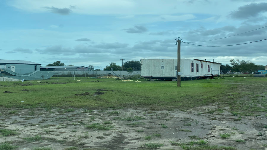
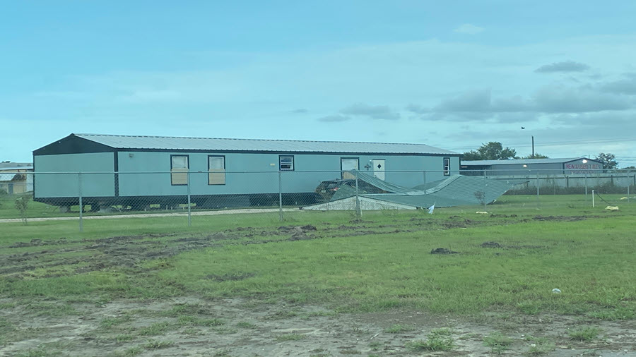
0240 PM HURRICANE PORT MANSFIELD 26.55N 97.43W
07/25/2020 WILLACY TX LAW ENFORCEMENT
LOCAL LAW ENFORCEMENT REPORTED WIDESPREAD
DAMAGE ACROSS PORT MANSFIELD. THIS INCLUDES
ROLLED OVER DAMAGED OR DESTROYED MOBILE
HOMES, AS WELL AS NUMEROUS POWER POLES DOWN.
0830 PM NON-TSTM WND DMG 1.5 N LA FERIA 26.18N 97.82W
07/25/2020 CAMERON TX AMATEUR RADIO
AMATEUR RADIO REPORT OF ROOF BLOWN OFF SHED
1.5 MI NORTH OF LA FERIA.
0845 PM NON-TSTM WND DMG MISSION 26.21N 98.32W
07/25/2020 HIDALGO TX PUBLIC
LARGE TREE BLOWN DOWN, DAMAGING VEHICLE IN
MISSION AT SHARY ROAD AND GRIFFIN PARKWAY
VICINITY.
0846 PM NON-TSTM WND DMG 1 W EDINBURG 26.29N 98.17W
07/25/2020 HIDALGO TX PUBLIC
LARGE HEALTHY TREE LIMBS DOWN AT A RESIDENCE
IN EDINBURG. REPORTED VIA SOCIAL MEDIA.
0906 PM HURRICANE 18 N PORT MANSFIELD 26.80N 97.47W
07/25/2020 GMZ135 TX BUOY
TCOON SITE RINCON DEL SAN JOSE (RSJT2)
MEASURED SUSTAINED WIND SPEED OF 56.9 KTS
AND WIND GUST OF 69 KTS.
0915 PM NON-TSTM WND DMG 2 WNW WESLACO 26.17N 98.01W
07/25/2020 HIDALGO TX EMERGENCY MNGR
EMERGENCY MANAGER REPORTED CARPORT BLOWN
INTO ROAD.
0915 PM NON-TSTM WND DMG 4 S EDCOUCH 26.23N 97.97W
07/25/2020 HIDALGO TX EMERGENCY MNGR
EMERGENCY MANAGER REPORTS A ROOF COLLAPSE
WITH FAMILY TRAPPED INSIDE. RESCUE CURRENTLY
UNDERWAY.
1030 PM FLASH FLOOD 2 SW PORT MANSFIELD 26.53N 97.45W
07/25/2020 WILLACY TX BROADCAST MEDIA
HIGHWAY 186 FLOODED OUTSIDE OF PORT
MANSFIELD; POSSIBLY CUTTING OFF THE CITY.
1030 PM FLOOD HARLINGEN 26.19N 97.69W
07/25/2020 CAMERON TX EMERGENCY MNGR
SEVERAL STREETS BECOMING FLOODED WITHIN THE
CITY LIMITS OF HARLINGEN.
1032 PM FLOOD HARLINGEN 26.19N 97.69W
07/25/2020 CAMERON TX EMERGENCY MNGR
SEVERAL STREETS FLOODED IN HARLINGEN.
1103 PM FLASH FLOOD LA FERIA 26.16N 97.82W
07/25/2020 CAMERON TX EMERGENCY MNGR
2 ONGOING WATER RESCUES IN LA FERIA.
1115 PM NON-TSTM WND DMG MCALLEN 26.21N 98.24W
07/25/2020 HIDALGO TX PUBLIC
PUBLIC REPORT OF LARGE HEALTHY TREE BROKEN
IN HALF AND SMALL TREE WITH NUMEROUS BROKEN
BRANCHES. MESSAGE RELAYED VIA SOCIAL MEDIA
WITH PHOTOS AND VIDEO.
1122 PM FLOOD LA FERIA 26.16N 97.82W
07/25/2020 CAMERON TX AMATEUR RADIO
AMATEUR RADIO OPERATOR REPORTED WATER UP TO
THE CURB ON STREETS IN LA FERIA.
1125 PM NON-TSTM WND DMG 1 N ELSA 26.31N 98.00W
07/25/2020 HIDALGO TX PUBLIC
PUBLIC REPORT OF LARGE TREE WITH BROKEN
LIMBS. REPORT VIA SOCIAL MEDIA VIDEO.
1200 AM NON-TSTM WND GST PHARR 26.18N 98.19W
07/26/2020 E50 MPH HIDALGO TX SOCIAL MEDIA
SHEET METAL CARPORT COLLAPSE AND TREES SNAPPED
1202 AM FLASH FLOOD HARLINGEN 26.20N 97.69W
07/26/2020 CAMERON TX PUBLIC
CORRECTS PREVIOUS FLASH FLOOD REPORT FROM
HARLINGEN. PUBLIC REPORTED FLOODING IN THE
AREA WITH WATER UP TO KNEES. WATER IS NOW
ENTERING HOMES. RELAYED VIA SOCIAL MEDIA.
0100 AM NON-TSTM WND GST EDCOUCH 26.29N 97.96W
07/26/2020 E50 MPH HIDALGO TX SOCIAL MEDIA
SEVERAL LARGE TREES UPROOTED AND BLOWN OVER.
0100 AM NON-TSTM WND GST MCALLEN 26.22N 98.24W
07/26/2020 E50 MPH HIDALGO TX SOCIAL MEDIA
SEVERAL REPORTS OF BUSINESS SIGNS, STREET SIGNS AND
TREES BLOWN OVER.
0100 AM NON-TSTM WND GST HIDALGO 26.10N 98.26W
07/26/2020 E50 MPH HIDALGO TX SOCIAL MEDIA
LARGE TREE BLOWN DOWN. ESTIMATED WIND 40 MPH
0200 AM NON-TSTM WND GST MCALLEN 26.22N 98.24W
07/26/2020 E50 MPH HIDALGO TX SOCIAL MEDIA
FAST FOOD RESTURANT SIGN BLOWN DOWN. LARGE TREE BLOWN
ON HOUSE. SEVERAL SHEET METAL ROOFS BLOWN OFF OR TORN
BACK, SEVERAL TREES UPROOTED.
0200 AM NON-TSTM WND GST PHARR 26.18N 98.19W
07/26/2020 E50 MPH HIDALGO TX SOCIAL MEDIA
SEVERAL TREES BLOWN OVER.
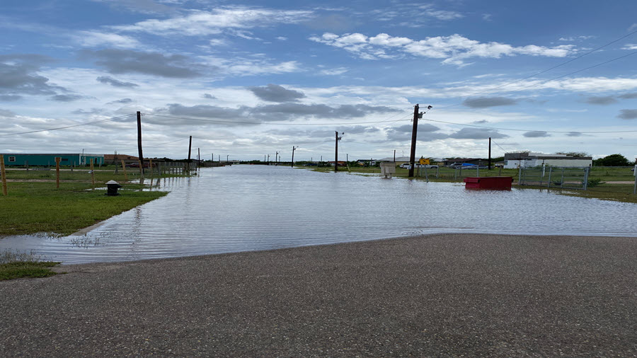
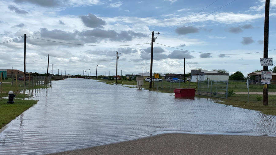
0230 AM FLOOD 2 NNW PHARR 26.20N 98.20W
07/26/2020 HIDALGO TX BROADCAST MEDIA
FLOODED PARKING LOT RELAYED VIA BROADCAST
MEDIA.
0255 AM NON-TSTM WND DMG 1 S ROMA 26.40N 99.00W
07/26/2020 STARR TX PUBLIC
TIN ROOF BLOWN OFF OF RAMIREZ SERVICE
STATION IN ROMA. PHOTO RELAYED VIA SOCIAL
MEDIA.
0300 AM NON-TSTM WND GST COMBES 26.24N 97.72W
07/26/2020 E50 MPH CAMERON TX SOCIAL MEDIA
SEVERAL TREES BLOWN OVER.
0334 AM TORNADO 3 E BROWNSVILLE 25.92N 97.44W
07/26/2020 CAMERON TX PUBLIC
ROOF BLOWN OFF OF HOUSE AND TREES DOWN ON
IOWA STREET. RELAYED VIA SOCIAL MEDIA. TIME
ESTIMATED.
0334 AM TSTM WND DMG 4 SE BROWNSVILLE 25.89N 97.42W
07/26/2020 CAMERON TX PUBLIC
PUBLIC REPORT OF POWER LINES DOWN NEAR
CALIFORNIA RD. AND S DAKOTA AVE. POSSIBLE
TORNADO. TIME ESTIMATED.
0335 AM TORNADO 3 ESE BROWNSVILLE 25.91N 97.43W
07/26/2020 CAMERON TX OTHER FEDERAL
AIRPORT MANAGER REPORTS DAMAGE ON THE
WESTERN SIDE OF BROWNSVILLE SOUTH PADRE
ISLAND INTERNATIONAL AIRPORT. AIRCRAFT WAS
MOVED, WINDOWS BLOWN OUT OF BUILDING(S) AND
DAMAGE TO PERIMETER FENCE. TIME ESTIMATED.
0345 AM TSTM WND DMG BROWNSVILLE 25.93N 97.48W
07/26/2020 CAMERON TX SOCIAL MEDIA
SIGNIFICANT DAMAGE OF FENCES AND ROOF AND SEVERAL TREES
BLOWN DOWN
0345 AM NON-TSTM WND GST BROWNSVILLE 25.93N 97.48W
07/26/2020 E50 MPH CAMERON TX SOCIAL MEDIA
SEVERAL REPORTS OF TREES AND BUSINESS SIGNS DOWN NEAR
SOUTHMOST AND BROWNSVILLE/SPI AIRPORT.
0500 AM NON-TSTM WND GST LOS BARRERAS 26.39N 98.92W
07/26/2020 E50 MPH STARR TX SOCIAL MEDIA
ROOF OF CARPORT TORN OFF
0510 AM FLOOD 1 WSW MISSION 26.20N 98.33W
07/26/2020 HIDALGO TX FIRE DEPT/RESCUE
CITY OF MISSION FD REPORTS OF WATER ON
HIGHWAY 83 BETWEEN CONWAY AVE AND HOLLAND
AVE.
0521 AM FLOOD MISSION 26.21N 98.31W
07/26/2020 HIDALGO TX EMERGENCY MNGR
MULTIPLE STREETS FLOODED IN THE CITY OF
MISSION.
0527 AM NON-TSTM WND DMG 2 SE EDINBURG 26.28N 98.15W
07/26/2020 HIDALGO TX PUBLIC
A RESIDENT IN EDINBURG, TX REPORTED SMALL
UPROOTED TREES AND SHINGLES BLOWN OFF OF
ROOF NEAR NOVIS AVE.
0545 AM FLASH FLOOD MISSION 26.21N 98.31W
07/26/2020 HIDALGO TX EMERGENCY MNGR
NUMEROUS WATER RESCUES IN SEVERAL AREAS
WITHIN THE CITY OF MISSION.
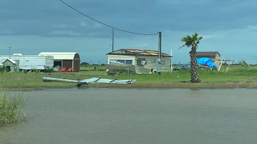
0700 AM FLOOD LOS FRESNOS 26.07N 97.48W
07/26/2020 CAMERON TX SOCIAL MEDIA
NEIGHBORHOOD STREET REPORTING 1 TO 2 FEET OF WATER.
0707 AM FLASH FLOOD MISSION 26.21N 98.32W
07/26/2020 HIDALGO TX PUBLIC
REPORT OF 12 INCHES OF WATER FLOWING ACROSS SHARY ROAD
NEAR GRIFFIN PARK BLVD IN MISSION
0800 AM FLOOD PHARR 26.18N 98.19W
07/26/2020 HIDALGO TX SOCIAL MEDIA
NEIGHBORHOOD STREET FLOODING WITH WATER RISING INTO
YARDS APPROACHING HOMES.
0800 AM FLOOD WESLACO 26.16N 97.98W
07/26/2020 HIDALGO TX SOCIAL MEDIA
NUMEROUS STREET AND ROADWAYS FLOODED WITH 1 TO 2 FEET
OF WATER.
0830 AM FLOOD LA FERIA 26.16N 97.82W
07/26/2020 CAMERON TX SOCIAL MEDIA
SEVERAL STREET AND FIELD FLOODING. WATER ESTIMATES 1 TO
2 FEET
0830 AM FLASH FLOOD MCALLEN 26.22N 98.24W
07/26/2020 HIDALGO TX SOCIAL MEDIA
CANAL ON S 23RD STREET RISING OUT OF ITS BANK, SEVERAL
ROADS FLOODED
0830 AM FLOOD MISSION 26.21N 98.32W
07/26/2020 HIDALGO TX SOCIAL MEDIA
1 TO 3 FEET WATER IN NEIGHBORHOOD STREETS, WATER RISING
NEAR HOMES
0830 AM NON-TSTM WND GST EDINBURG 26.30N 98.16W
07/26/2020 E50 MPH HIDALGO TX SOCIAL MEDIA
2 18-WHEELERS BLOWN OVER.
0830 AM FLASH FLOOD 2 SE EDINBURG 26.28N 98.15W
07/26/2020 HIDALGO TX PUBLIC
WATER ENTERING HOMES ON THE SOUTHEAST SIDE
OF EDINBURG. EVENT TIME BASED ON TIME THE
REPORT WAS RECEIVED.
0846 AM FLASH FLOOD EDINBURG 26.30N 98.16W
07/26/2020 HIDALGO TX SOCIAL MEDIA
1 TO 2 FEET OF STREET FLOODING AT 14TH AND MAHL. WATER
NEARING SOME APARTMENTS AND HOMES. WATER UP TO VECHICLES
TIRE WELL AND BOTTOM OF DOORS SOME PARTIALLY SUBMERGED.
0850 AM FLOOD ALAMO 26.19N 98.12W
07/26/2020 HIDALGO TX SOCIAL MEDIA
SEVERAL REPORTS OF STREET FLOODING. ESTIMATES 1 TO 2
FEET OF WATER COVERING THE ROADS
1000 AM FLOOD ALTON 26.29N 98.31W
07/26/2020 HIDALGO TX SOCIAL MEDIA
STREET FLOODING AT 4 MILE AND INSPIRATION. 1 TO 2 FEET
OF WATER COVERING THE STREET
0615 PM NON-TSTM WND GST MISSION 26.21N 98.32W
07/26/2020 E50 MPH HIDALGO TX SOCIAL MEDIA
ROOF DAMAGE TO SCHOOL DISTRICT MAINTENANCE SHED.
0643 PM NON-TSTM WND GST WESLACO 26.16N 97.98W
07/26/2020 E50 MPH HIDALGO TX SOCIAL MEDIA
SEVERAL TREES AND SOME POWER POLES BLOWN OVER
0805 PM FLASH FLOOD SANTA ROSA 26.26N 97.83W
07/27/2020 CAMERON TX EMERGENCY MNGR
FLOOD WATER LEVELS HAVE RISEN TO THE
DOORSTEPS OF HOMES; ANY FURTHER INCREASE IN
WATER LEVELS MAY LEAD TO WATER ENTERING THE
HOMES.
0805 PM FLASH FLOOD LA FERIA 26.16N 97.82W
07/27/2020 CAMERON TX EMERGENCY MNGR
ONGOING WATER RESCUES IN THE CITY OF LA
FERIA WITH RENEWED RISING FLOOD WATERS FROM
RECENT RAINFALL OVER THE LAST HOUR OR TWO.
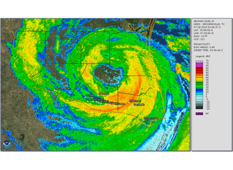
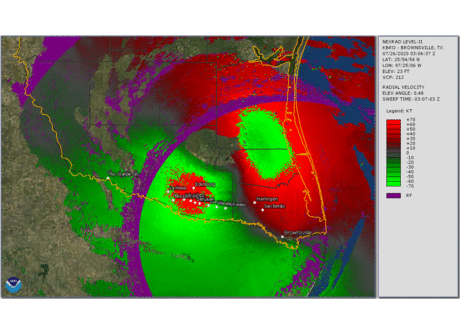
| July 25th, 11 AM to 10 PM: Landfall Reflectivity | July 25th, 11 AM to 10 PM: Landfall Radial Velocity |
|---|---|
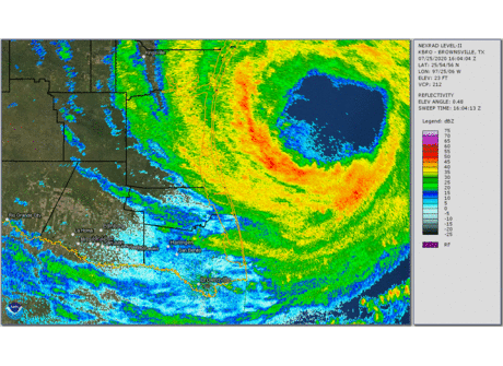 |
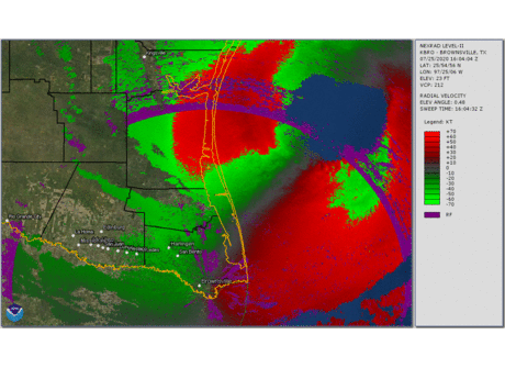 |
| July 25/26th, 10 PM to 10 AM: Inland Reflectivity | July 25/26th, 10 PM to 10 AM: Inland Radial Velocity |
 |
 |
| July 27th, 3 to 9 PM: Post-Hanna Feeder Band, Reflectivity | |
 |
|


| Rio Grande at Rio Grande City | Arroyo Colorado near Harlingen |
|---|---|
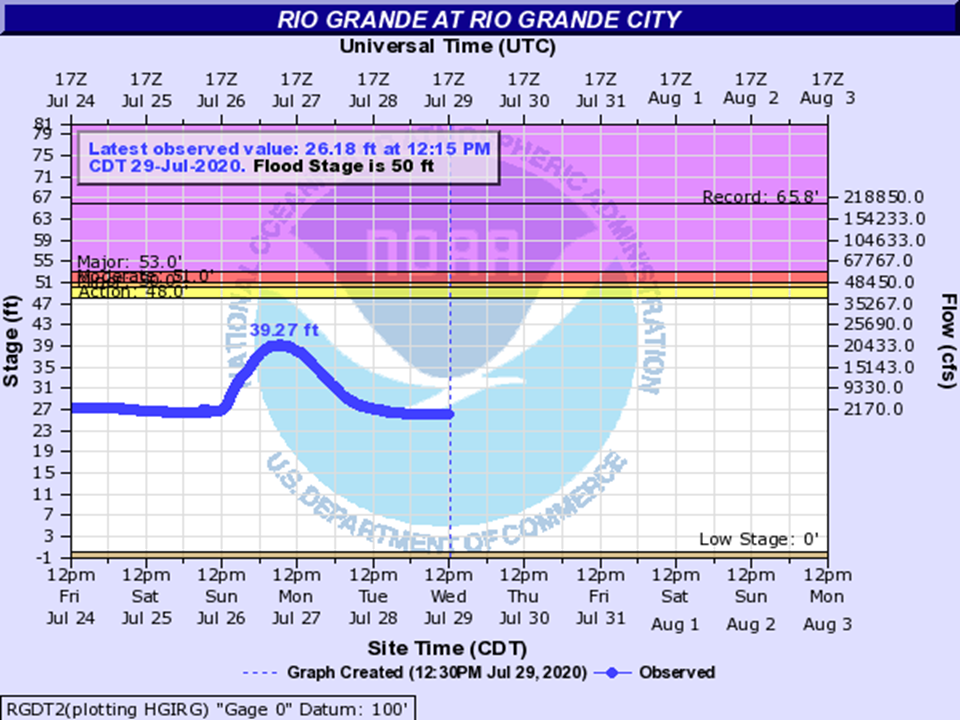 |
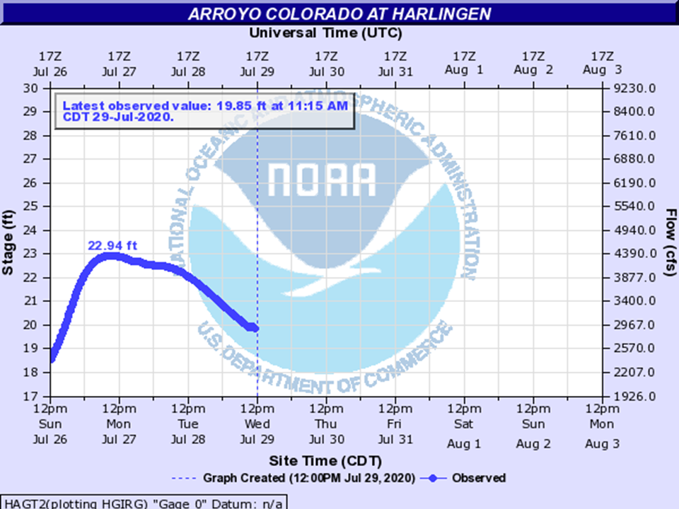 |
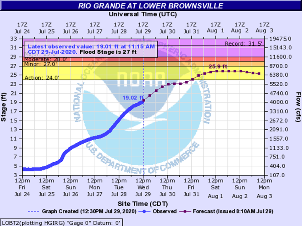
| Rio Grande near San Benito | Rio Grande near Brownsville |
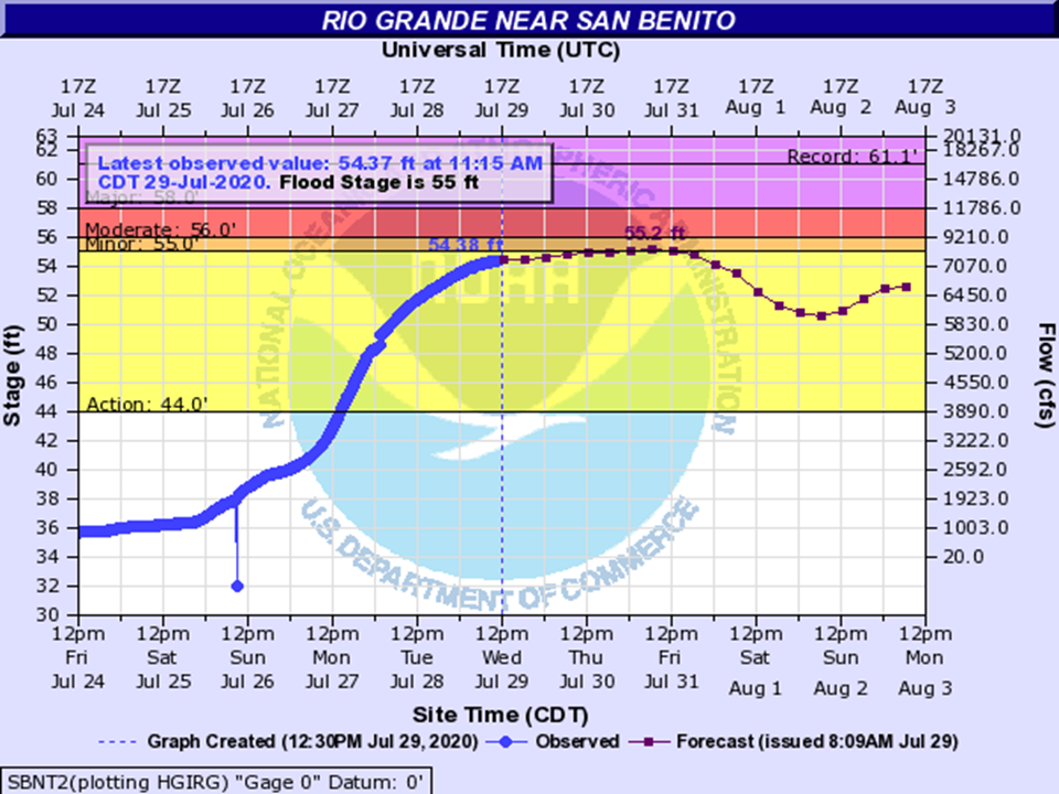 |
 |
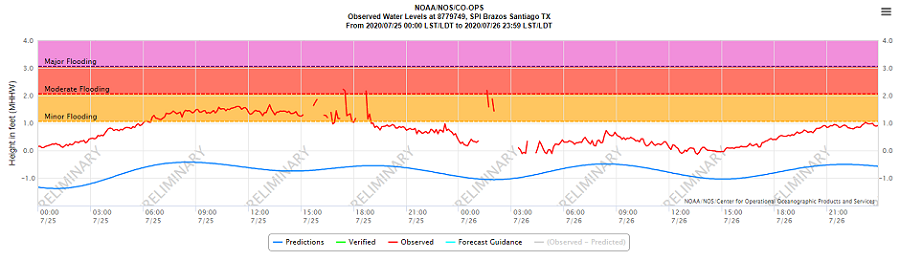
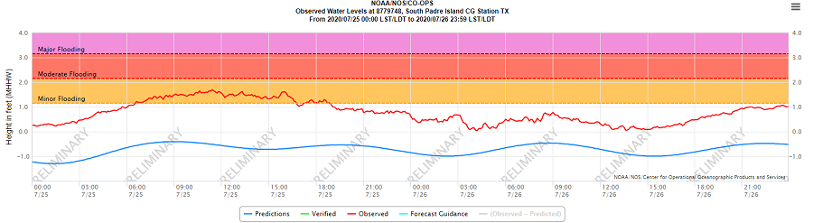
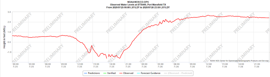
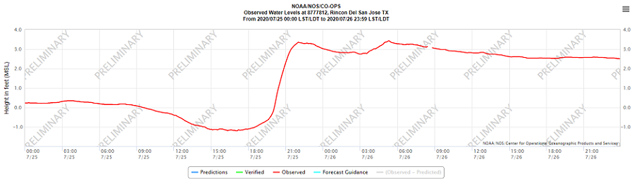
Hurricane Hanna's late intensification and landfall location along the Kenedy County coast (North Padre Island) east of Rincon del San Jose spared the popular...and populated...beach resort of South Padre Island little more than a six hour period of tidal run-up and minor overwash centered around high tide the morning of July 25th (833 AM CT). As winds increased rapidly from the west (offshore flow) by mid to late afternoon, run-up ceased. At the same time, those westerly winds piled an estimated 1 to 2 feet of Laguna Madre Bay water onto the Laguna Madre side of South Padre Island, with high water into docks and low lying areas that normally don't see any. Morning high surf, up to 10 feet by the Isla Blanca Jetty, was trimmed sharply by afternoon with the strong offshore flow. By Saturday night, rough surf returned on south to southeast winds, but tides slid back to about one half foot above predicted values, which were at low astronomical levels. In fact, it was these low astronomical levels that spared potentially more significant flooding into the dunes on July 25th.
Farther north, tide levels were higher, including on the shore at the Port Mansfield jetty. In Kenedy County, along North Padre Island, there was likely 3 or more feet of storm surge inundation in uninhabited beaches. A overflight video of this part of the island will be shared soon, including any new cuts that the more intense storm surge generated in this area.
Photographic and video evidence from Padre Island National Seashore (PINS) indicated exactly this. Photos from a webcam at the Mansfield Cut (not shown) showed rough and confused surf well into the dunes. The video above, as well as overflight photos, showed extensive beach erosion (calving) of the dunes in extreme northeast Willacy and much of Kenedy County, between mile mark 5 and mile mark 60 (the southern extent of PINS).
A list of measured and estimated peak tides follows, based on Mean Higher High Water (MHHW) and Mean Sea Level (MSL). The zero point of MHHW is a close approximation of where the edge of the foam creates the shoreline. Negative values expand the beach; positive values contract the beach. For example, when values are at 1 foot above MHHW, the water level is now about 1 foot deep. The surf will "run up" farther, reducing the amount of usable beach. At 1.5 feet above MHHW, water typically begins reaching the dunes at wider beaches, and sneaks into the dunes a little bit at narrower sections. Brazos Santiago, located just inshore along the south edge of the Isla Blanca Jetty, is a good proxy for conditions on South Padre Island. We have no other proxy observations for the barrier island from near the Cameron/Willacy County line through Baffin Bay.
| Location | Height Above Datum (feet) | Datum Type |
|---|---|---|
| Brazos Santiago (Cameron Co; on beach) | 1.67 | MHHW |
| South Padre Island CG )Cameron Co; Laguna Madre) | 1.70 | MHHW |
| Port Isabel (Cameron Co; Inshore Laguna Madre) | 1.56 | MHHW |
| Realitos Peninsula (Northeast Cameron Co) | 2.51* | MSL |
| Port Mansfield (Northeast Willacy Co) | 2.62* | MSL |
| Rincon del San Jose (Kenedy Co) | 3.43* | MSL |
| Baffin Bay (Southeast Kleberg Co) | 1.83* | MSL |
*Data estimated using Mean Sea Level instead of MHHW. All (*) but Realitos Peninsula have no matching flood categories.
Images showing tide level and those into minor flood range, with available data during Hanna, are shown below. "Spikes" in the data for Brazos Santiago were disregarded.
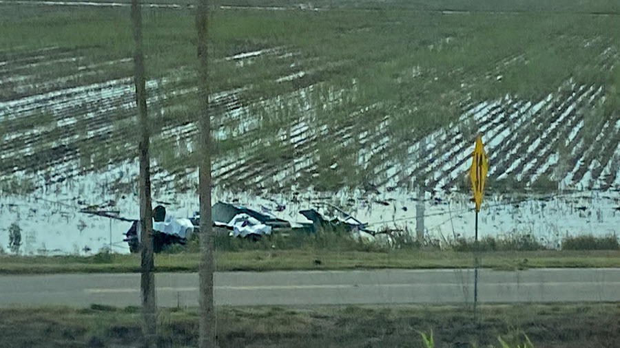
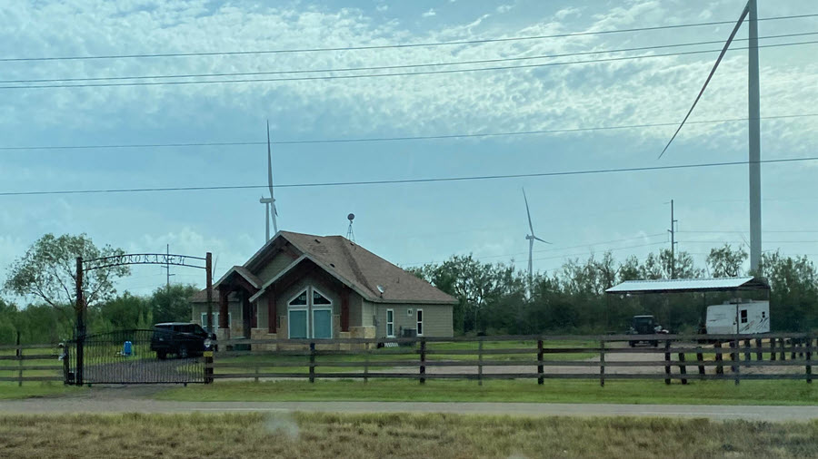
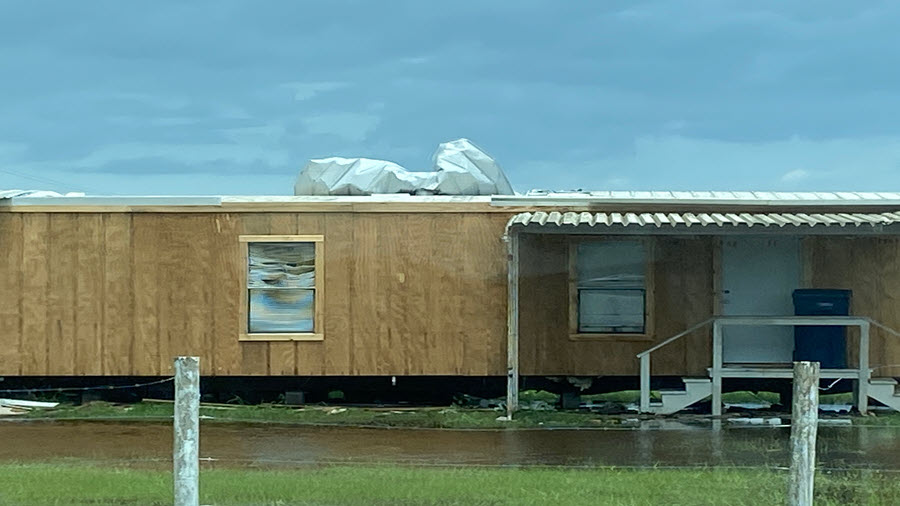
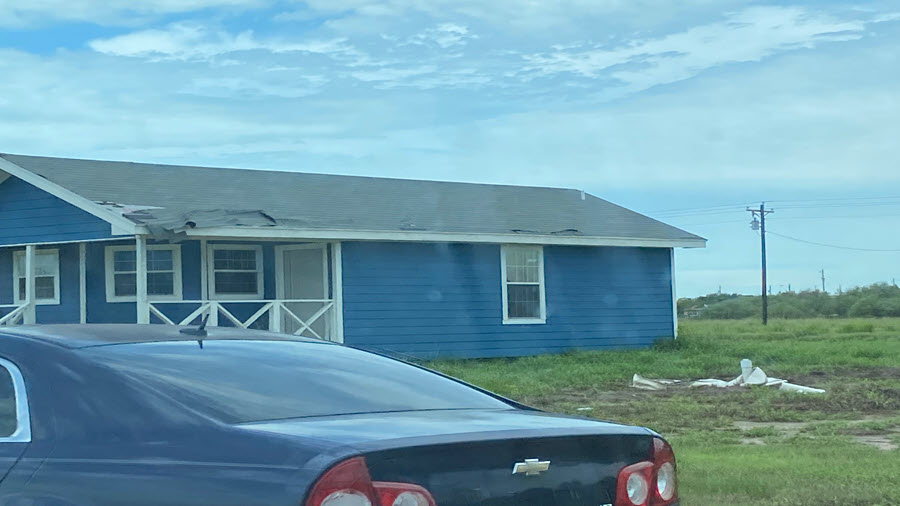
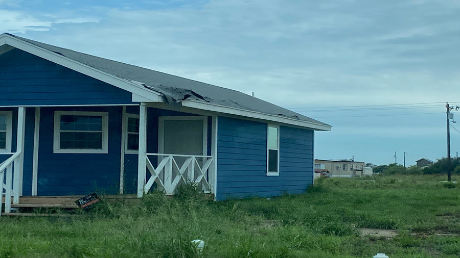
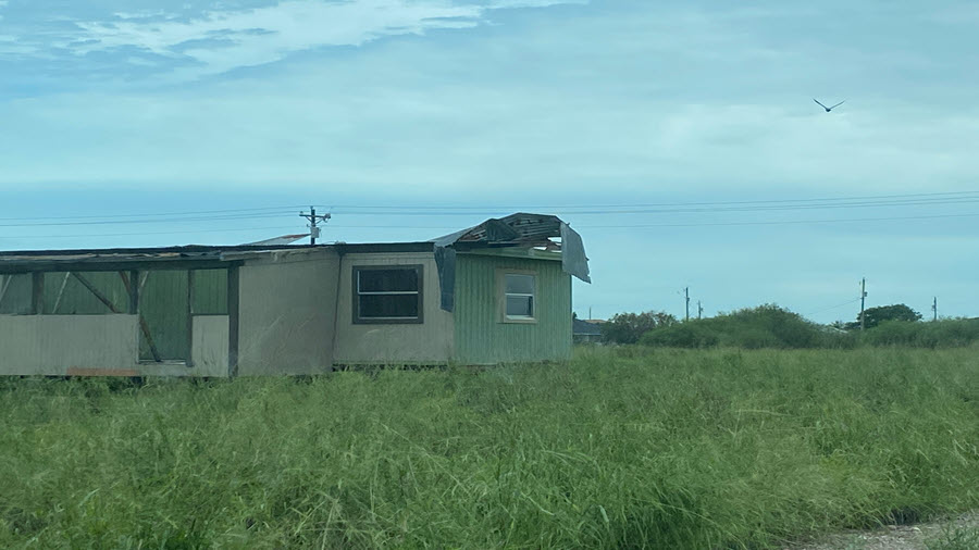
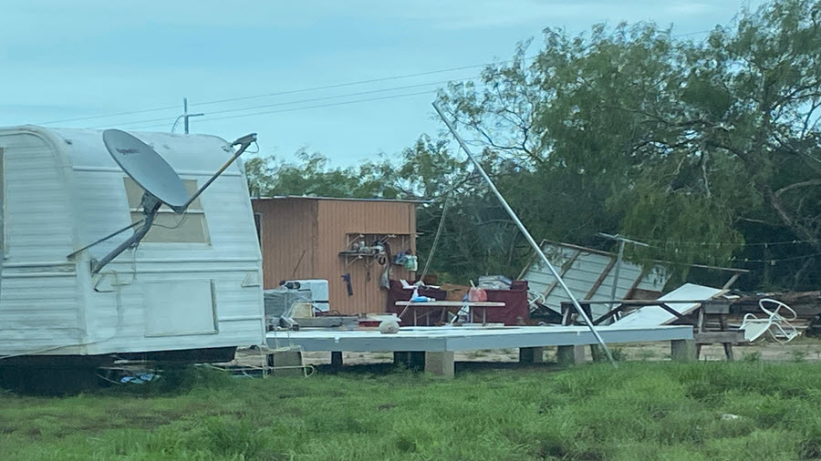
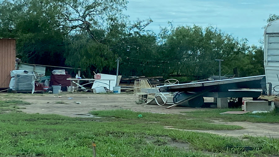
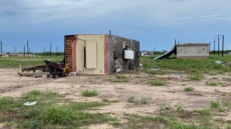
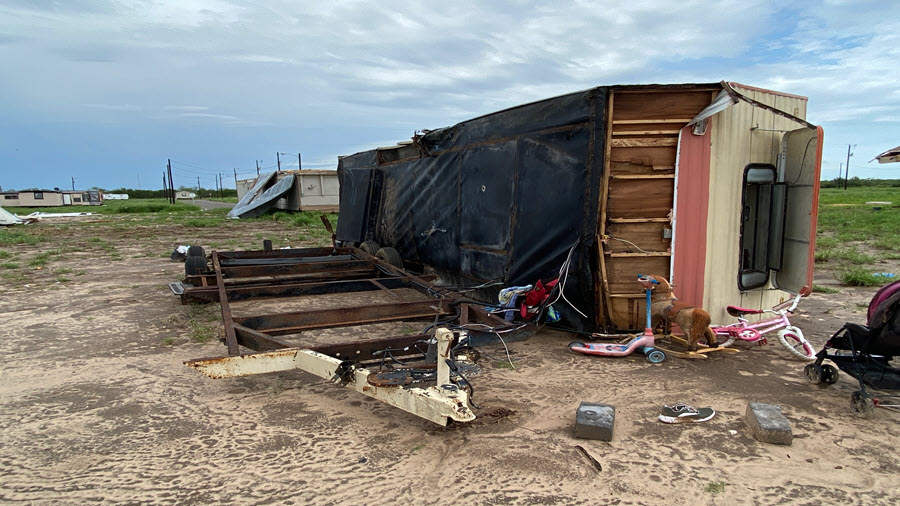
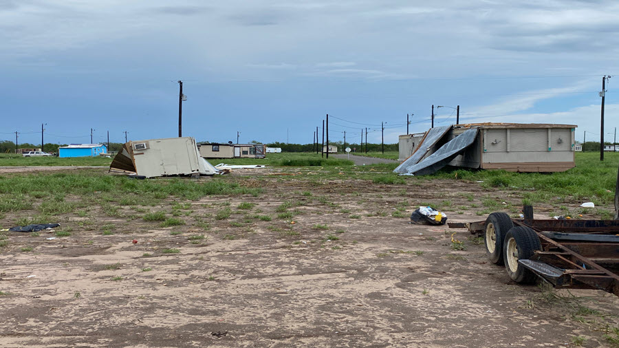
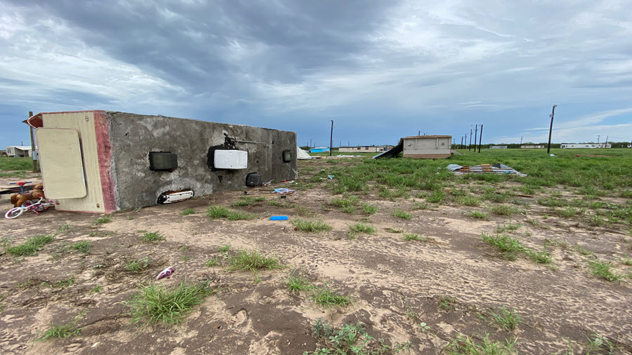
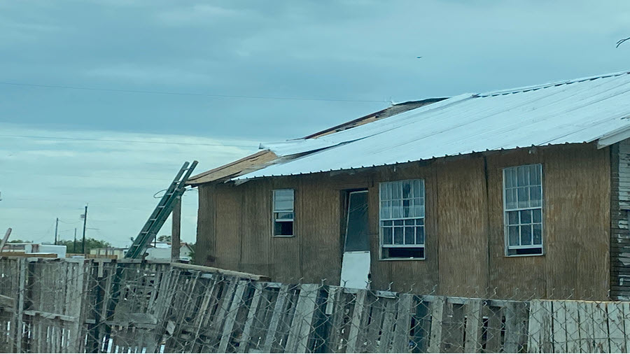
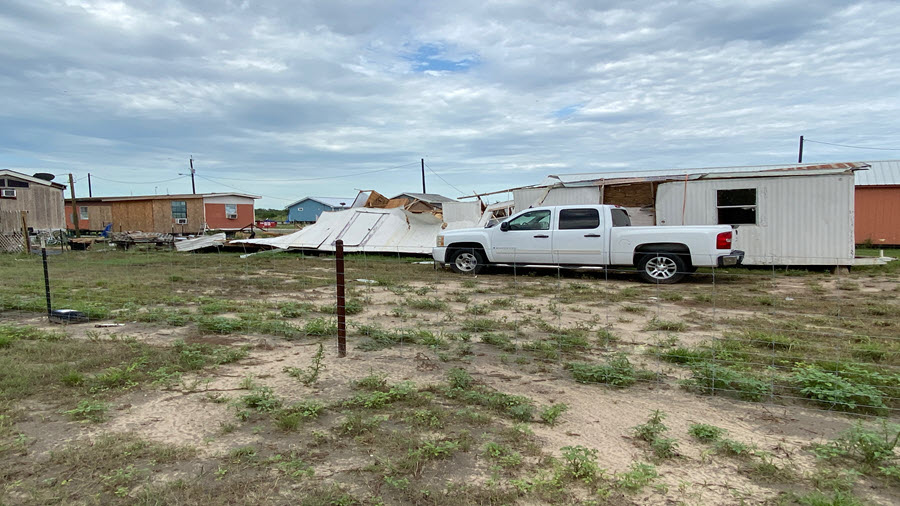
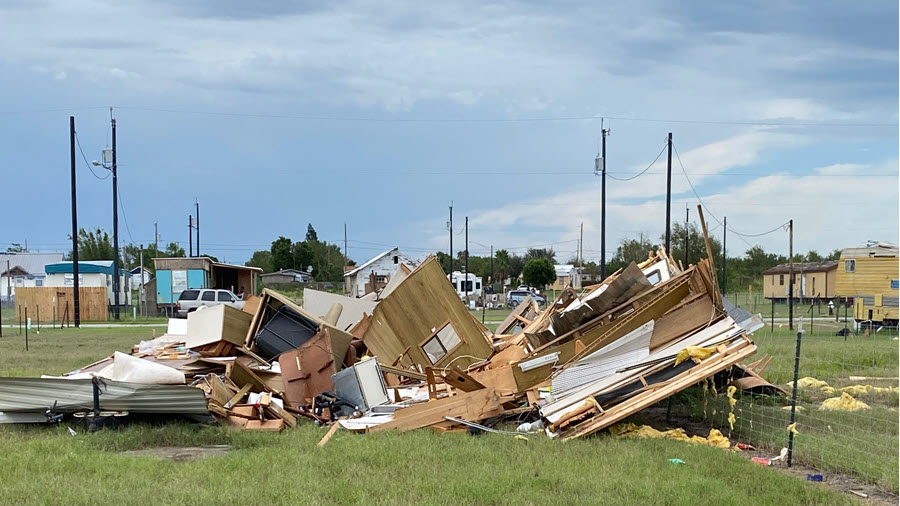
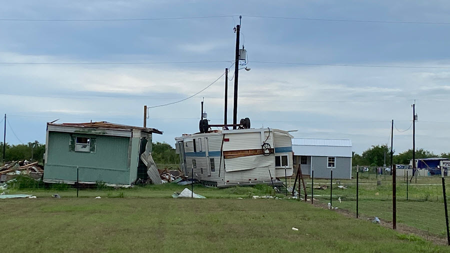
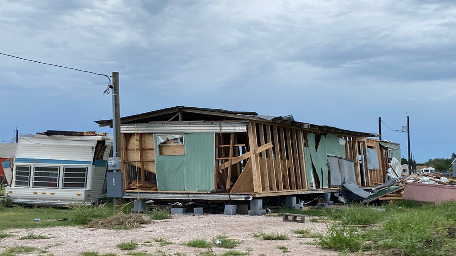
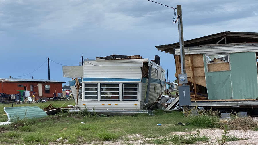
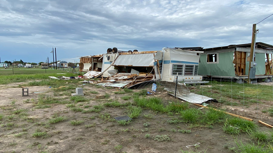
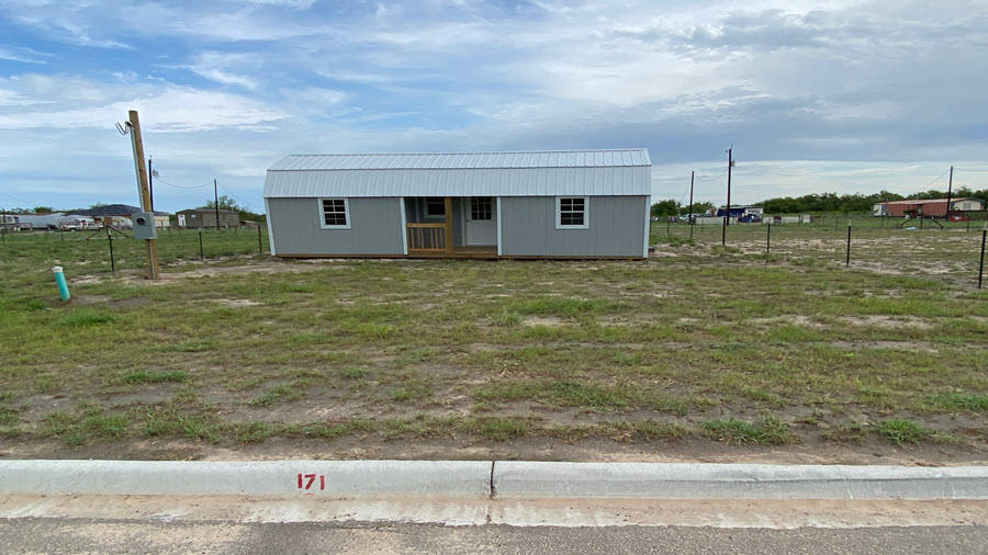
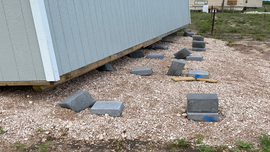
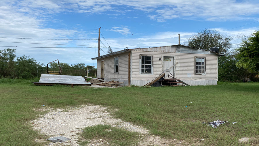
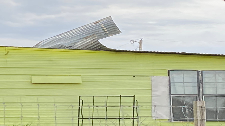
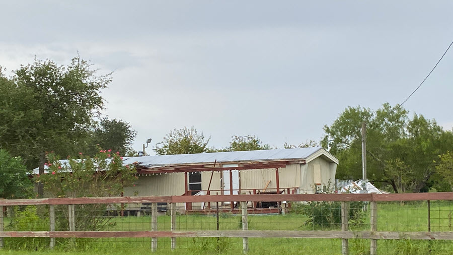
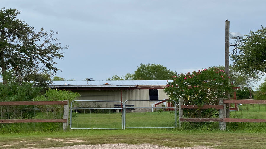
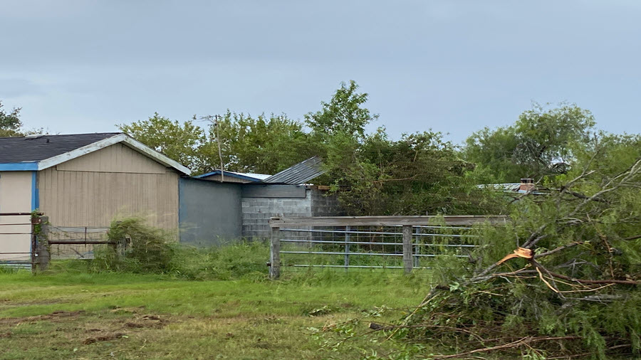
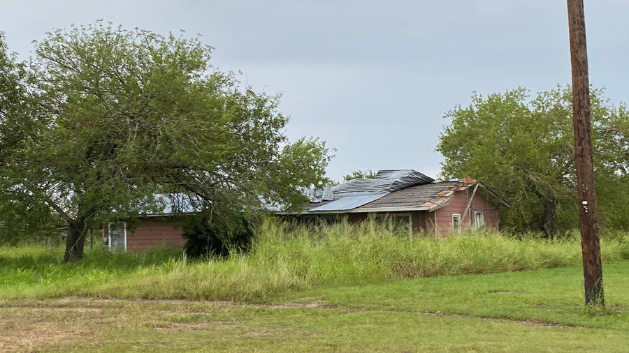
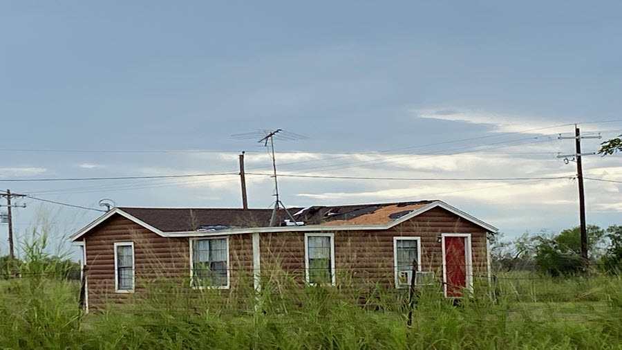
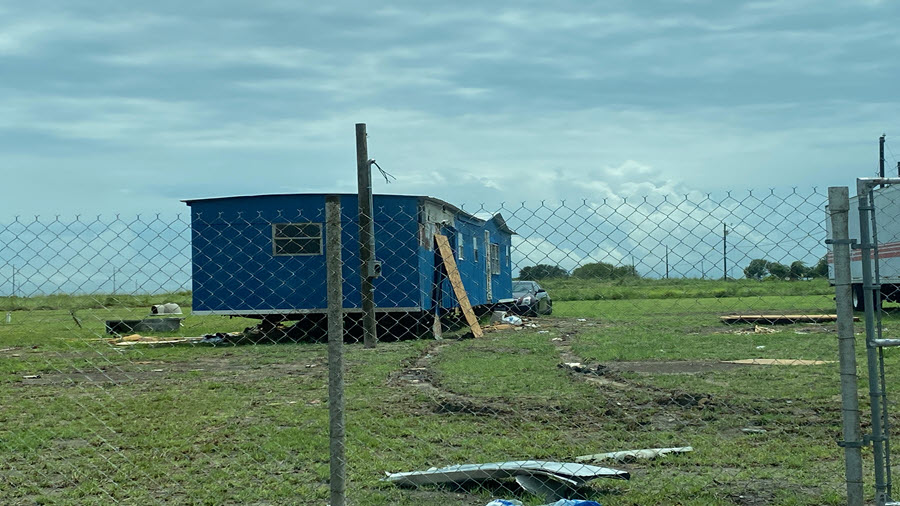
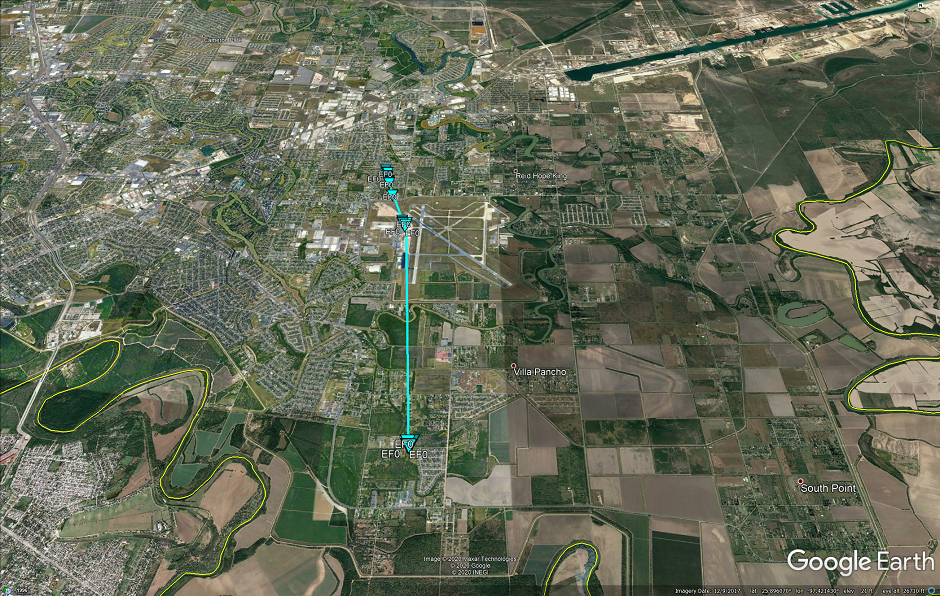
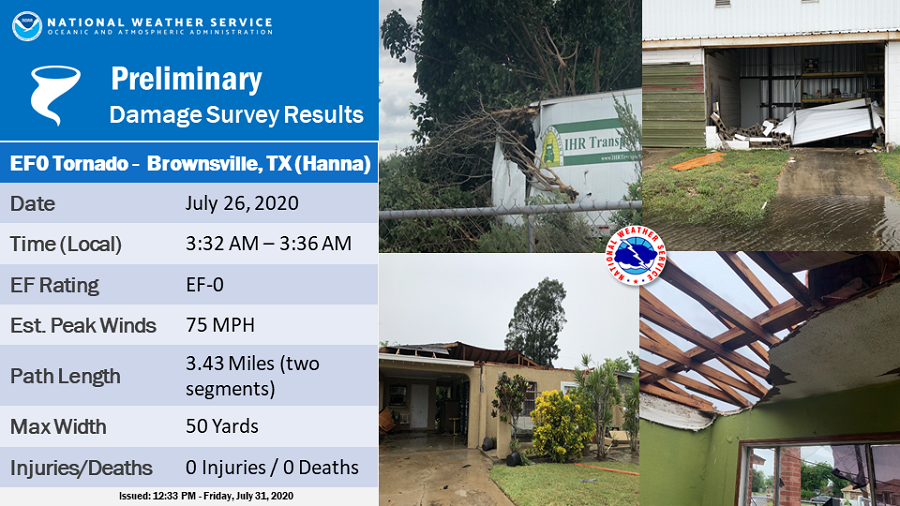
PUBLIC INFORMATION STATEMENT...UPDATED
NATIONAL WEATHER SERVICE BROWNSVILLE TX
200 PM CDT Fri Jul 31 2020

...NWS DAMAGE SURVEY FOR 7/26/2020 TORNADO EVENT IN BROWNSVILLE...

.Overview...Hurricane Hanna made landfall along the Kenedy county
coast on the evening of July 25, 2020. As Hanna pushed inland, its
eastern outer rain bands produced several areas of rotation. One
area of stronger rotation developed south of Brownsville just across
the Rio Grande in Mexico. The Brownsville radar briefly detected
a debris signature as it moved northward toward the Brownsville
airport. The Brownsville airport, in addition to residents in
nearby neighborhoodS, reported wind damage. Therefore, a damage
survey was conducted this afternoon to confirm a brief tornado.

Rating:                 EF-0
Estimated Peak Wind:    75 MPH
Path Length (Statute):  3.43 MILES (SEGMENTED)
Path Width (Maximum):   50 YARDS
Fatalities:             0
Injuries:               0

Start Date:             July 26, 2020
Start Time:             332 AM CDT
Start Location:         4.7 Miles East-Southeast of Brownsville
Start LAT/LON:          25.8729/-97.4287

End Date:               July 26, 2020
End Time:               336 AM CDT
End Location:           4 Miles Northeast of Brownsville
End LAT/LON:            25.9222/-97.4355

Updated:  An initial touchdown was discovered about 2.3 miles south
of Brownsville/South Padre Island International Airport.  Here, an
empty tractor trailer was moved on an angle into a stand of trees,
an unanchored travel trailer was flipped, a storage shed was flattened,
and several mesquite trees lost large limbs. A few minutes later, several
areas of damage occurred on the west side of the Brownsville airport.
A dozen windows were blown out of an airplane hangar building, an
unanchored old jet staircase was flipped and a garage door
collapsed inward. In addition, a 737 airplane was moved into a
hangar, causing damage to the hangar wall. No damage was noted to
the plane itself. As the tornado moved to the north northwest,
several large tree limbs were snapped, in addition to a weak
uprooted tree. Finally further north, two homes lost large sections
of their roofs with most walls still standing. The brief tornado
then lifted with no other tornado damage found.

EF SCALE: THE ENHANCED FUJITA SCALE CLASSIFIES
TORNADOES INTO THE FOLLOWING CATEGORIES.

EF0...WEAK......65 TO 85 MPH
EF1...WEAK......86 TO 110 MPH
EF2...STRONG....111 TO 135 MPH
EF3...STRONG....136 TO 165 MPH
EF4...VIOLENT...166 TO 200 MPH
EF5...VIOLENT...>200 MPH

NOTE:
THE INFORMATION IN THIS STATEMENT IS PRELIMINARY AND SUBJECT TO
CHANGE PENDING FINAL REVIEW OF THE EVENT AND PUBLICATION IN
NWS STORM DATA
For a map, specific survey details, and photos of wind damage along the general path of the tornado in east Brownsville, click the image below. Download Google Earth to interact with the map after clicking it.
An overflight drone video of the damage, courtesy of the City of Brownsville Fire Department, can be viewed here.
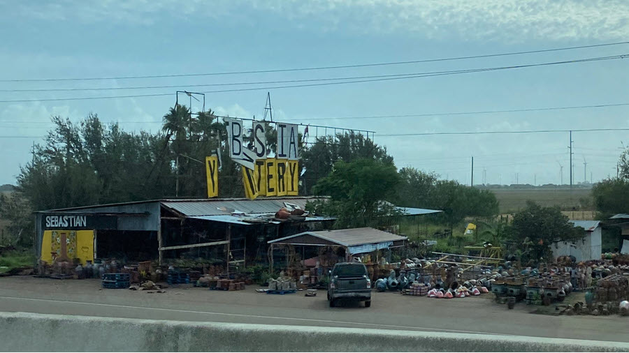
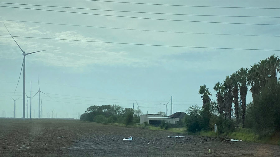
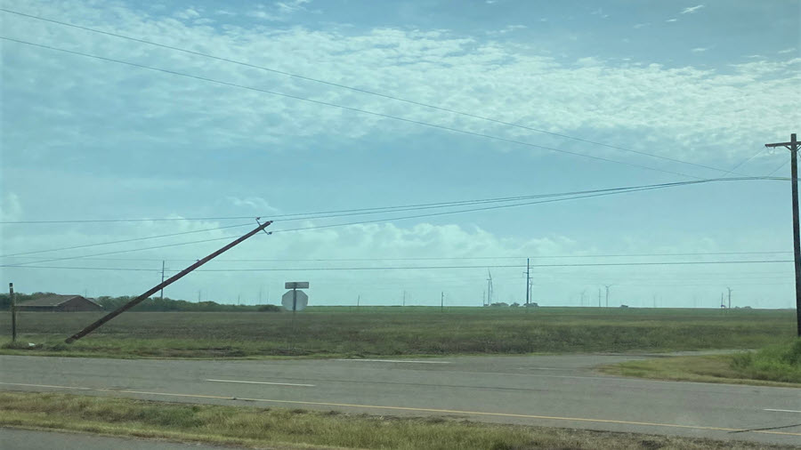
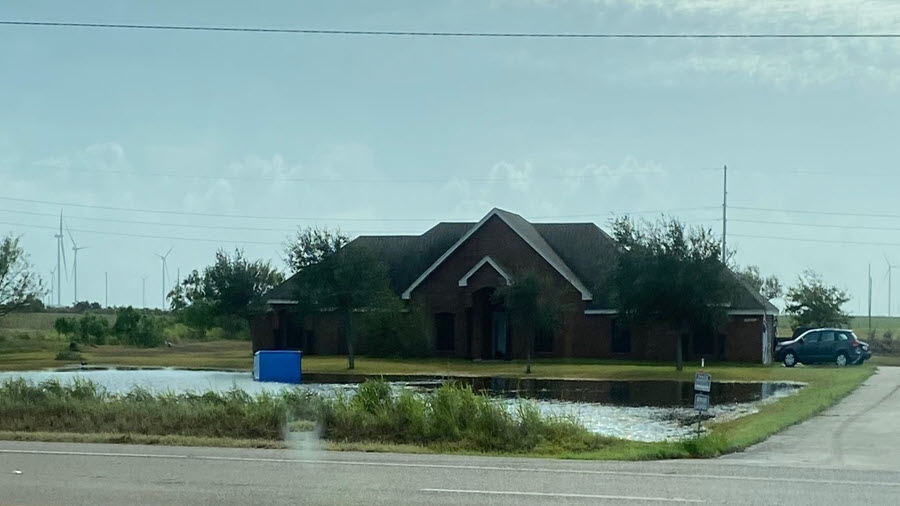
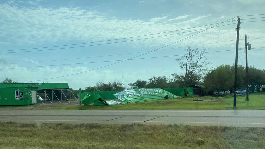
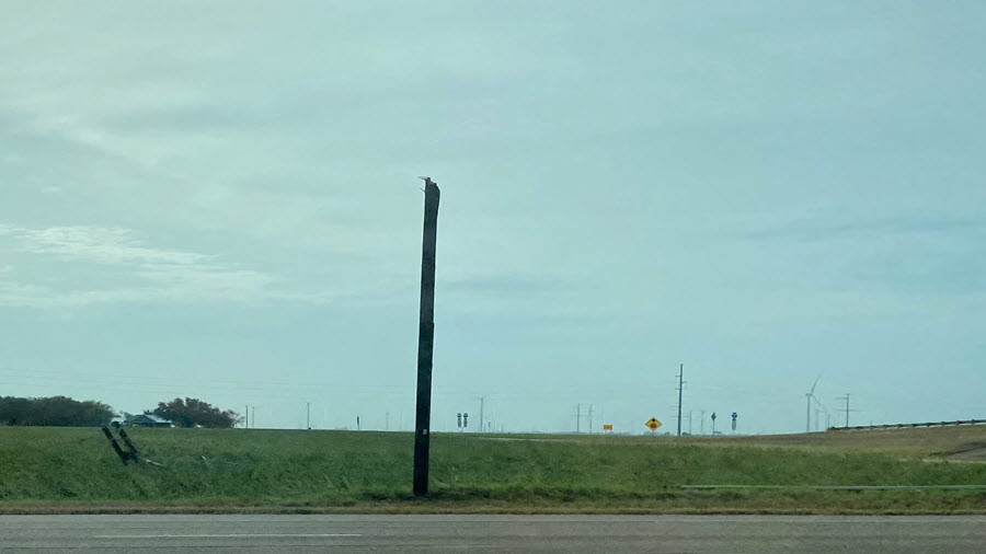
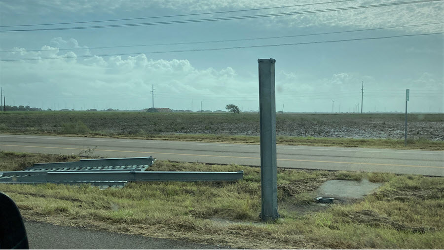
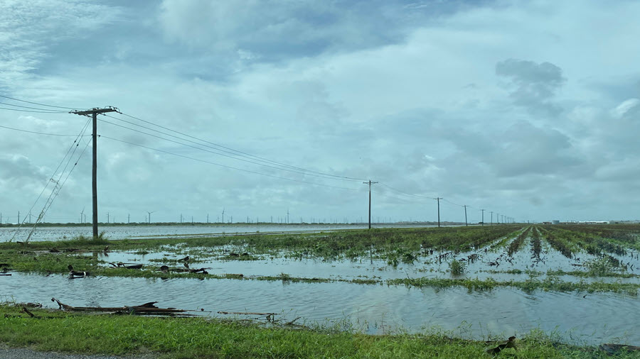
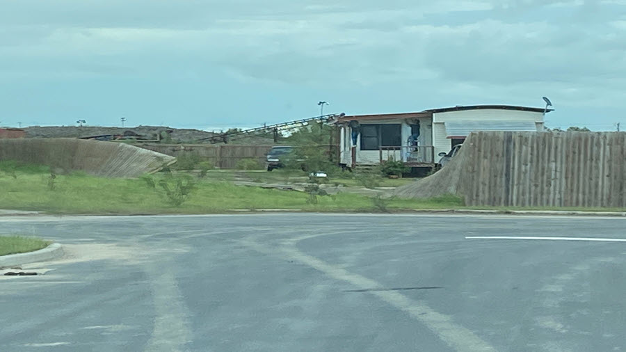
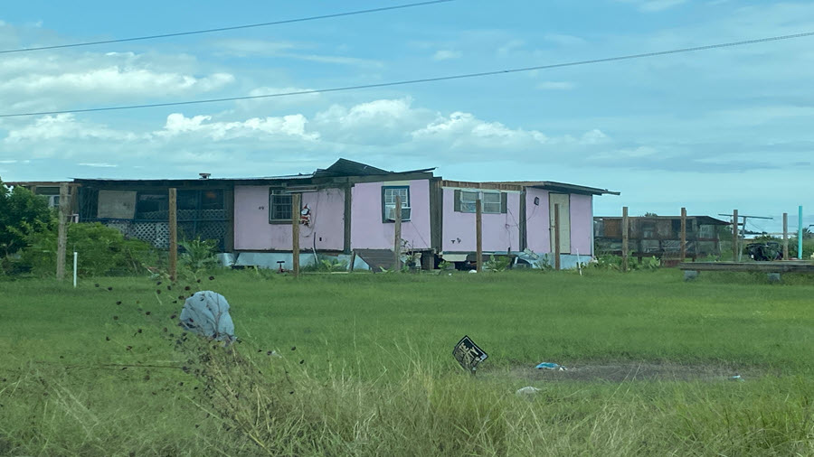
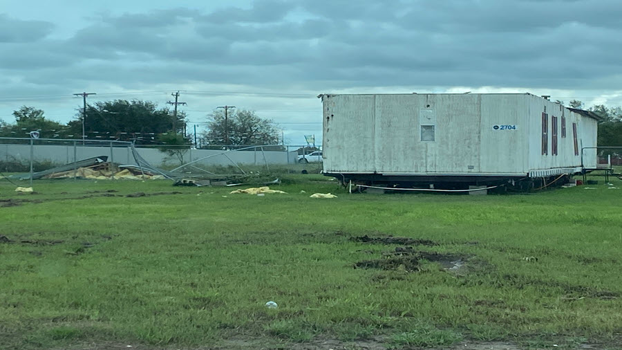
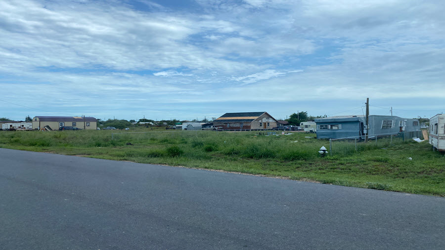
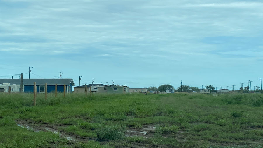
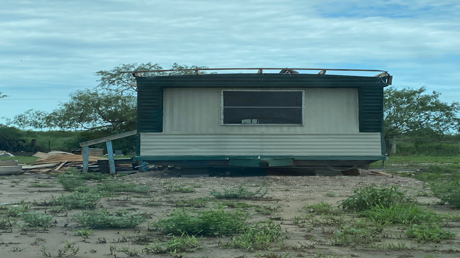
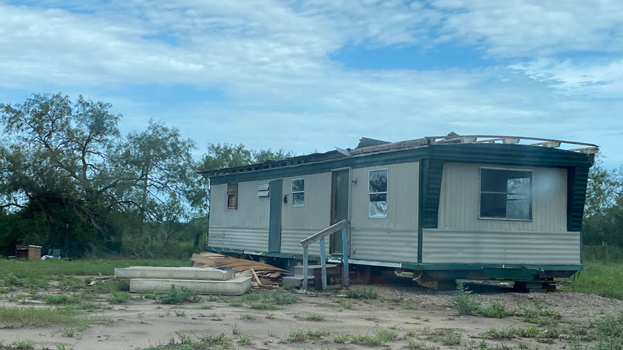
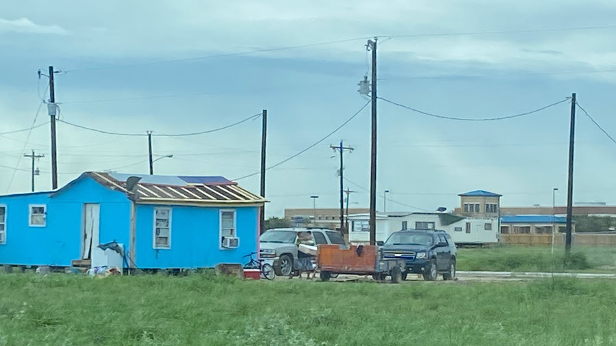
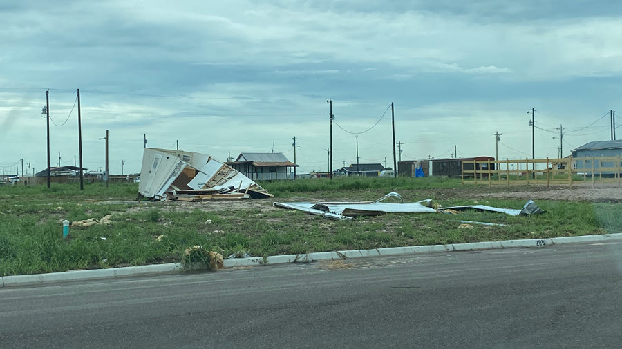
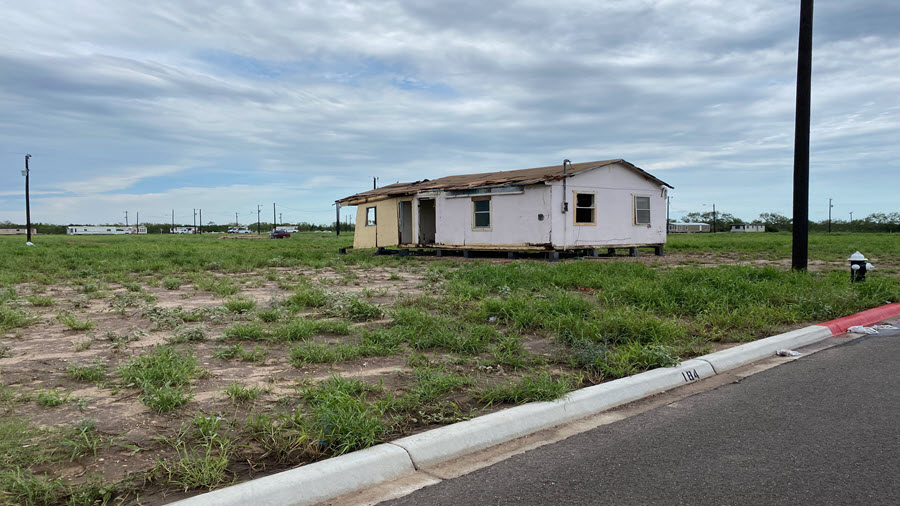
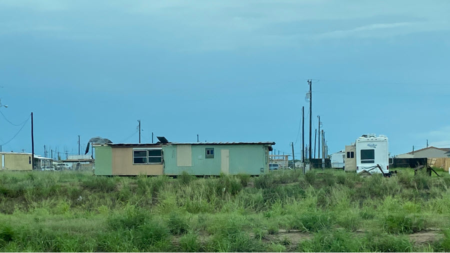
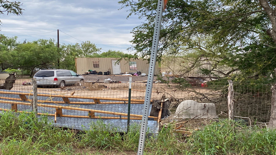
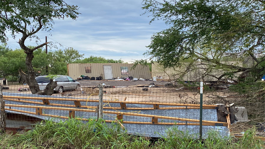
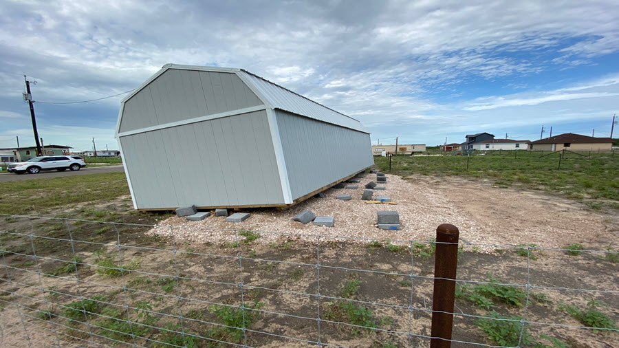
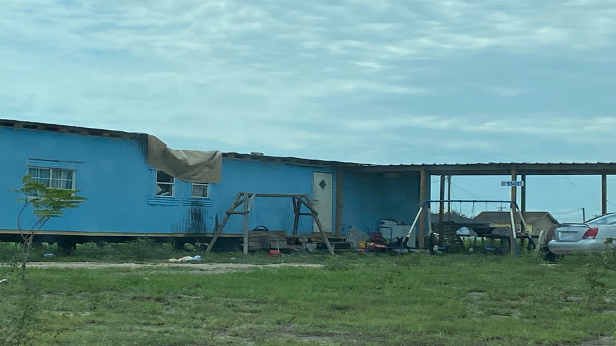
A sampling of photos - including a brief summary for quick use - is shown below, and a radar loop follows.
| July 26th, 307 AM to 402 AM: Radial Velocity Loop of East Brownsville Tornado |
|---|
 |

