 A broad tropical wave originating in the western Caribbean Sea moved across the Yucatan peninsula on June 15th and 16th, 2018. The slow moving but persistent system approached the Texas coast on Sunday, June 17th before finally arriving on June 18th. As the center axis of the wave passed the longitude of the coastline, the gates opened to repeated surges of tropical moisture deep into the atmosphere with origins in the western Caribbean Sea. A series of upper level disturbances interacted with this wave throughout its life cycle and helped to maintain a broad area of low pressure at all levels of the atmosphere for the period from June 18th through June 22nd across Rio Grande Valley, and the adjacent Gulf waters. Several surface-based boundaries and convergence along the coastline also aided the production of heavy rainfall. Individual convective "systems" spun in place at several points during the event, including:
The wave and upper level disturbances finally exited southwest into north central Mexico on June 22nd, bringing a weekend of rain-free but oppressively hot and humid conditions to conduct broad recovery activity across the region.
Bout after Bout after Bout Ends the Drought but Wreaks Memorable Havoc
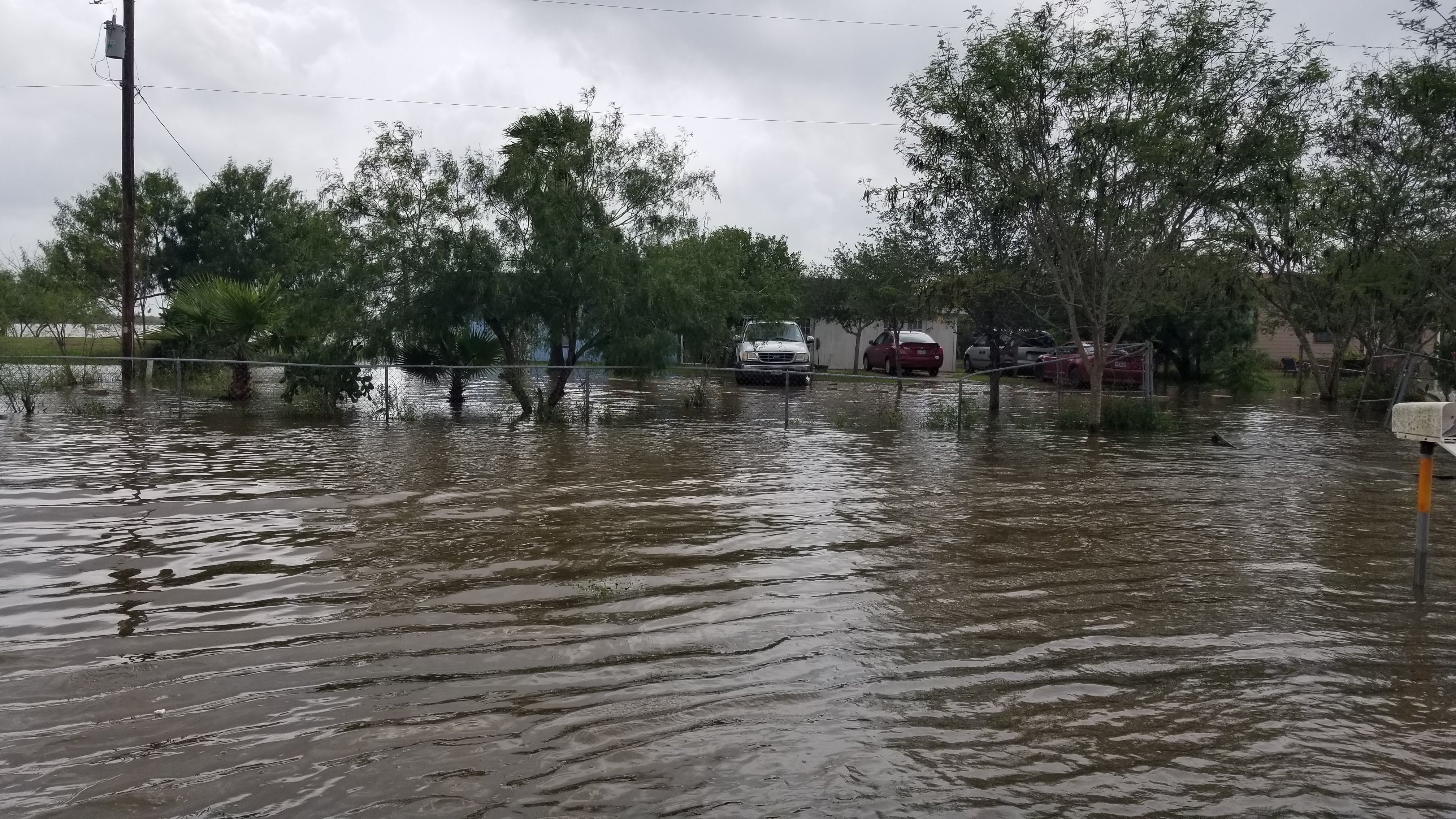
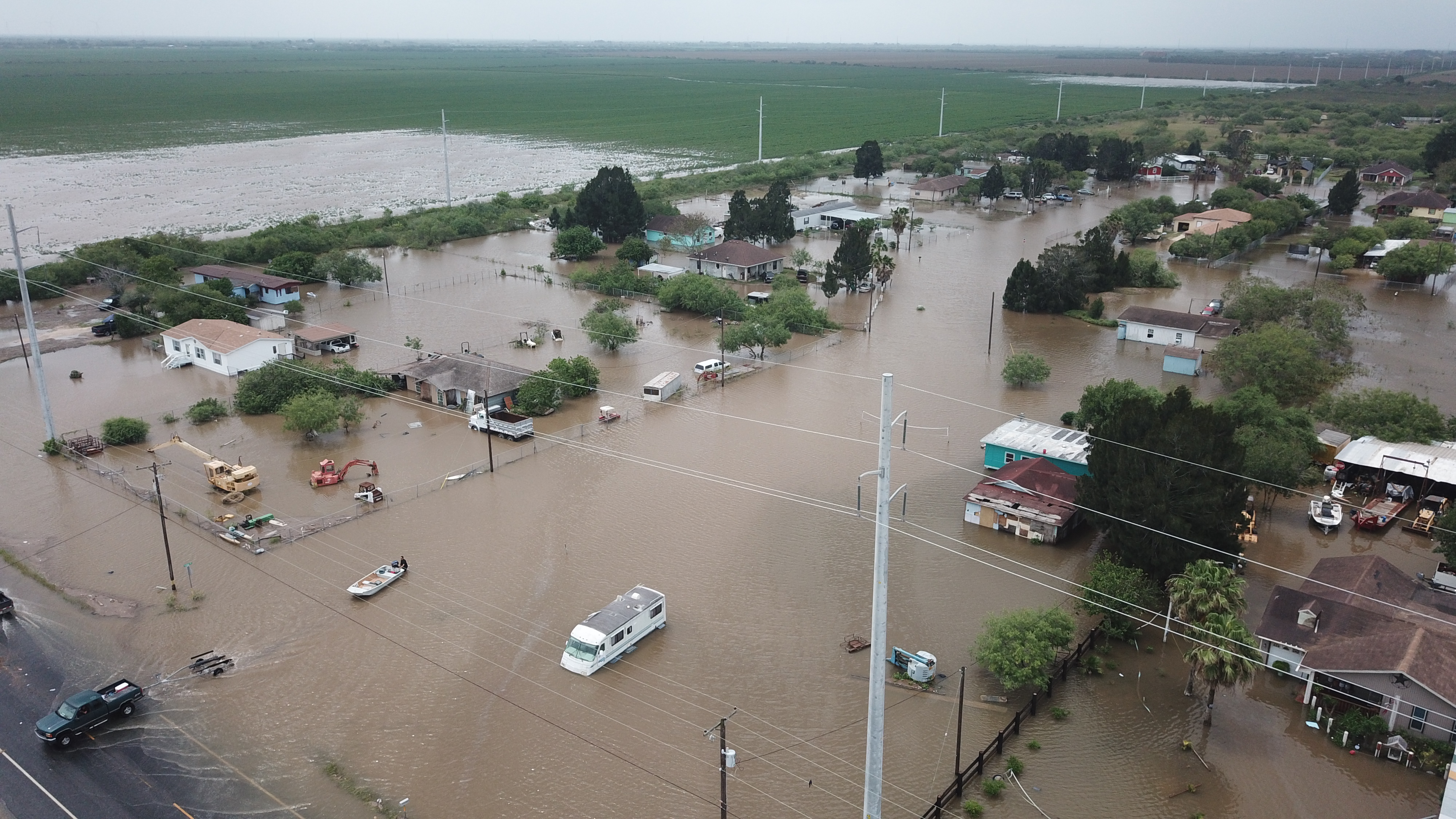
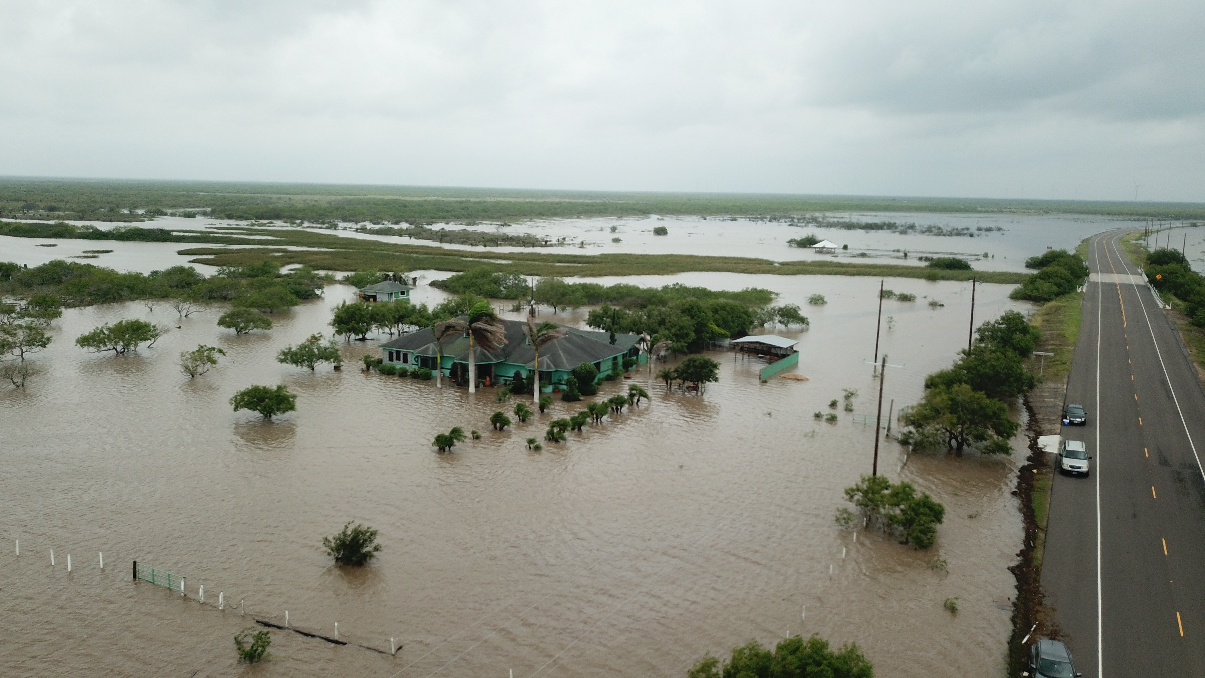
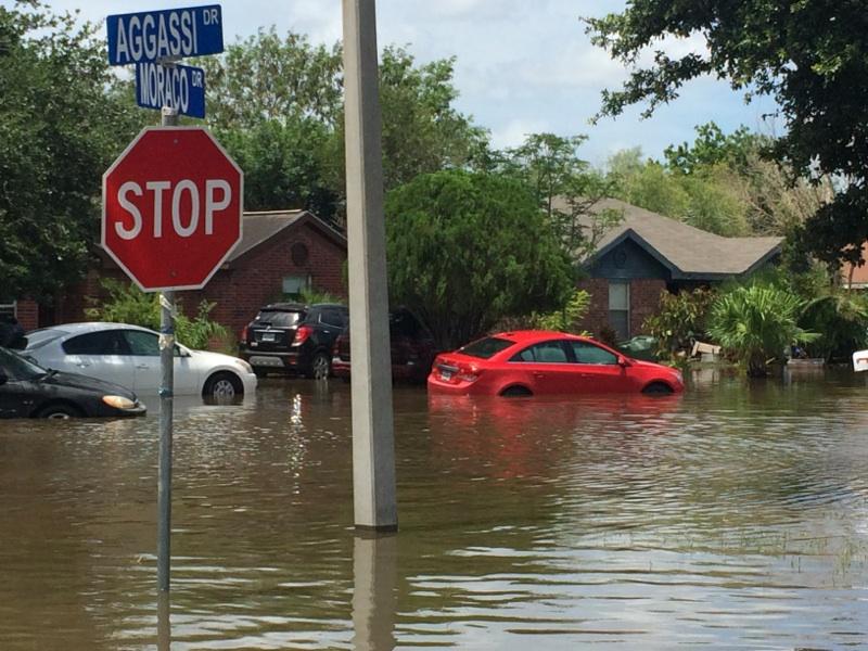
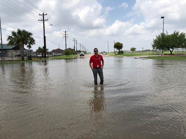
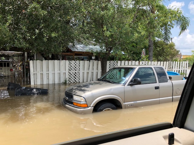
A wise Texas meteorologist from the early 20th Century aptly stated: "Texas is a State of perpetual drought, broken by the occasional [devastating] flood". How right he was, nearly 100 years later. Severe-level drought, which had turned grass and rangeland crispy and yellow-brown and burned up non-irrigated crops by mid June, was replaced in days with scenes of several feet of water that flooded thousands of vehicles, inundated several thousand homes and businesses with 18 inches to more than 3 feet of water, and hundreds of rescues of persons and pets. As of June 25, state Emergency Declarations were declared for Cameron, Hidalgo, and Willacy County. Damage estimates were likely to run into the hundreds of millions of dollars, and the breadth of impact was perhaps even greater than that of Hurricane Dolly in 2008.
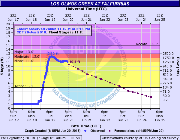
The first bout of heavy rain was more welcome than anything else: A pre-dawn roaring downpour that dropped 2 to more than 3 inches between Los Fresnos and Harlingen on June 18th. The morning rain, which spared many other locations, was a teaser of much more to come. The first serious flooding event developed during the late night and early morning hours of June 19th across the South Texas Brush Country of Duval, Jim Wells, and Brooks County. Torrential rains of more than 12 inches by midday west of Falfurrias, and flooding of at least 1 to 2 feet of water covered the streets of the city, closing many of them. Soon after, Palo Blanco Creek overspilled its banks and contributed additional water flows, and Los Olmos Creek spiked quickly and by evening reached flood stage by late afternoon and would crest just over moderate stage (12.32 feet) around 745 PM June 19th - the third highest crest in the modern record and highest since 1971 (remnants of Hurricane Fern).
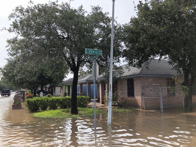
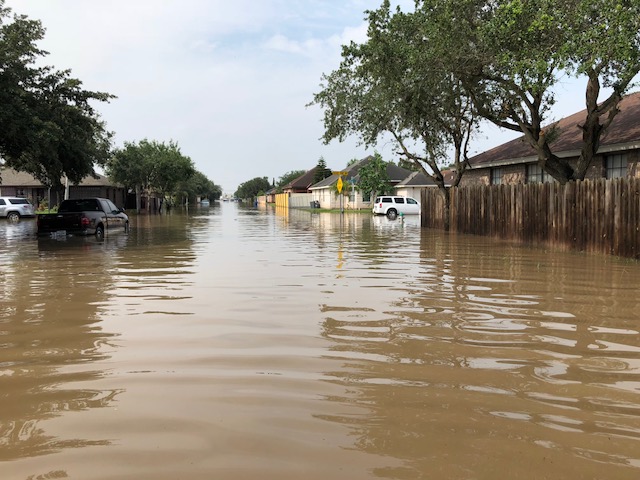
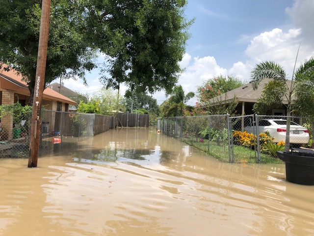
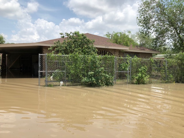
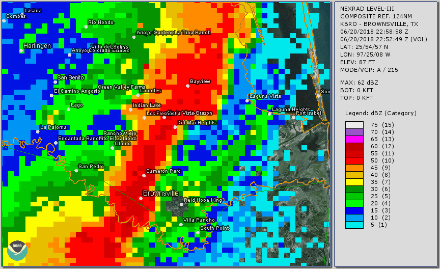
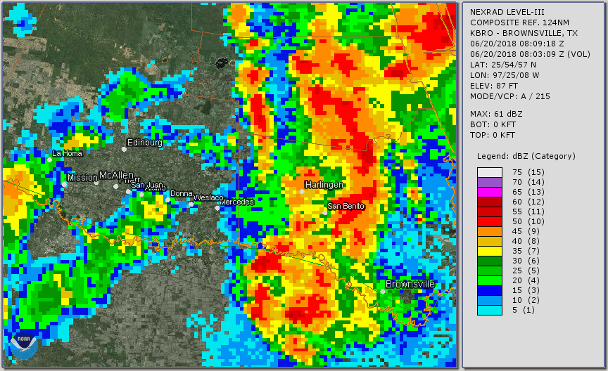
The second flooding rain event struck Cameron County from Brownsville to Los Fresnos, when a slow moving line of thunderstorms from west to east intersected the sea breeze and stalled, dumping 3 to 5 inches of rain over a 2 to 3 hour period and caused significant street flooding and some road closures in the area. The "big one" followed just 12 hours later, when the peak of the tropical moisture plume was lifted by an embedded upper level disturbance parked between the central Rio Grande Valley and the South Texas Brush Country. Incredible rainfall rates of up to 5 or more inches per hour struck the highly populated mid Valley between the east side of the McAllen Metro region to Harlingen, with peak rainfall just north of Weslaco and Mercedes. 11 to 13 inches fell in just a few hours at and near the Mid Valley Airport in Weslaco, though amounts may have been a couple inches higher in the heaviest rain core several miles northeast of this location. The cooperative observing station on the Mid Valley Airport grounds reported 11.36 inches in 3 hours! Drainage was unable to handle the deluge, and widespread flooding with photo and video evidence of at least 3 to 5 feet of water depth in many streets of each town ensued. The number of homes, businesses, and vehicles impacted by the floodwaters exceeded that from the October 22-24 Atmospheric River Event. As of this writing, Weslaco City estimates were more than 2500 homes, 100+ businesses, and at least 2500 vehicles with various degrees of damage. The homes and businesses had a minimum of 18 inches of floodwater depth inside portions of each. Data from Mercedes had not been received as of June 26th.
The third event struck Cameron County - again - in nearly the same locations between Brownsville and northeast of Los Fresnos that same afternoon. This time, 4 to 6 inches fell, making for two day totals of 6 to 10 inches in the area and triggering additional flooding, especially in and northeast of Los Fresnos where several neighborhoods were inundated by a foot or more of water, with estimates of 3 feet or more of standing water in poor drainage locations as well as open fields. Parts of Harlingen were dealt a "triple" blow with rain during the afternoon of the 19th, morning of the 20th, and afternoon of the 20th. 10 inches fell there as well.
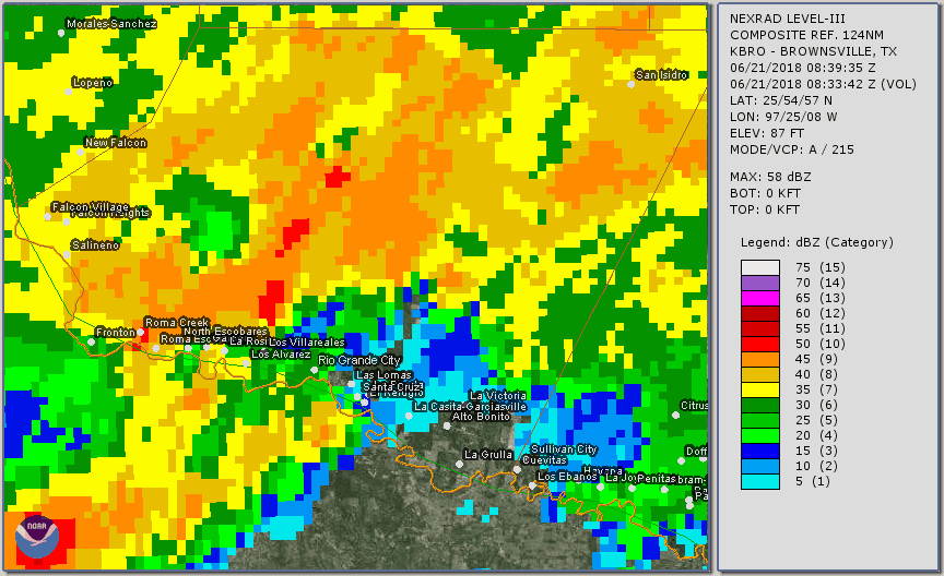
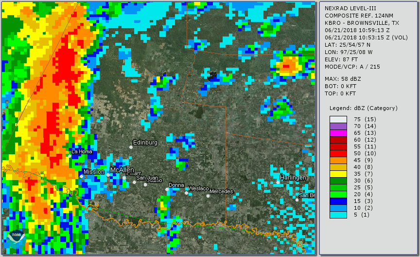
By evening of the 20th, a defined swirl of upper level energy - in part due to the interaction of the earlier thunderstorm system with the broader tropical wave - settled over the four corners of Brooks/Hidalgo/Starr/Jim Hogg County. The system would drift little overnight; another complex of thunderstorms would spin in from the northeast overnight and reach Starr County, eventually dropping more than 7 inches from the ranches north of Rio Grande City to Rio Grande City itself, where local arroyos reached and overtopped their banks and at least one swift water rescue was required during the pre-dawn hours of the 21st. The big story of that day was just beginning, however, as a "fire hose" of moisture on the immediate east side of the swirl was lifted into a persistent band of torrential rains that began in western Hidalgo County before daybreak, where estimates of 6 to 8 inches fell, to the McAllen metro area between 7 AM and Noon, where estimates of another 6 to 10 inches fell, based on radar and ground truth observations. At least 2700 residences and businesses were estimated to be flooded in many neighborhoods in Mission and McAllen, as the additional rain fell on previously saturated ground from 3 to 6 inches that fell during the pre-dawn hours of June 20th.
For Cameron County, one more act was to come, as multiple shorter-lived bands of torrential rains rolled through Brownsville to Los Fresnos (again!) dropping another 1 to nearly 3 inches from late morning through mid afternoon of the 21st, which aggravated ongoing high water and flood conditions as well as recovery operations. The final act of the entire event occurred during the pre-dawn hours of June 22nd, when a final cluster rotated from the central Tamaulipas coast to the Mission/McAllen area as the tropical wave wheezed to its demise while moving southwestward into north central Mexico. An additional inch or two of rain aggravated ongoing flooding in these areas, as well as in Starr County near the Rio Grande.
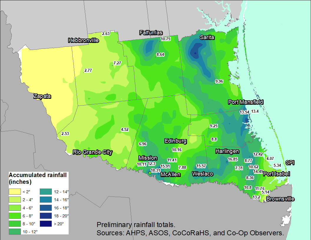
Rainfall totals are listed in Rainfall tab of this report. In general, between 12 and more than 18 inches fell in the McAllen/Mission area, up to 16 inches fell near Weslaco, with the potential of 18 inches between Weslaco and Mercedes; 8 to 17 inches in Harlingen; 10 to 15 inches between Brownsville and Los Fresnos, 10 to 15+ inches in Port Mansfield and through the King Ranch of Kenedy County, 12 inches near Falfurrias, and more than 8 inches in parts of Starr County.
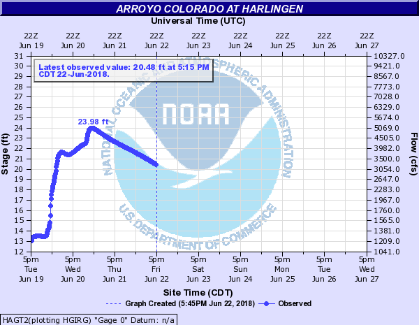
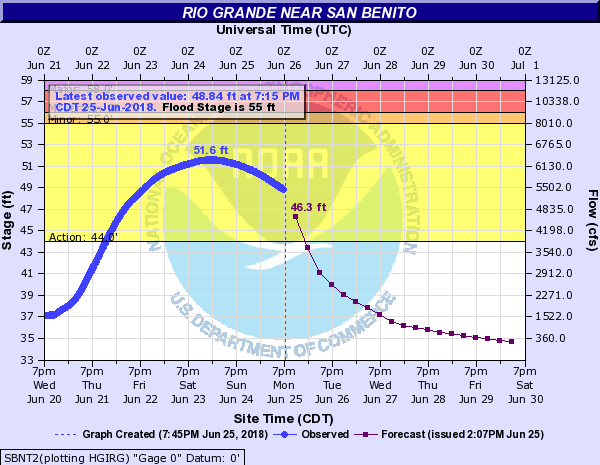
In addition to arroyos, drainage canals and ditches, resacas, and arroyos that filled to the brim and in some cases overspilled, gaged creeks and a portion of the Rio Grande also swelled to flood levels. The following crests were noted at three locations across the Rio Grande Valley and Deep South Texas:
Tale of the Tape - Initial Impact Statistics
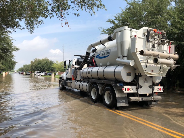
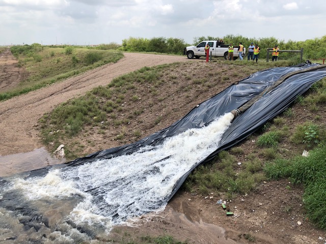
The Great June 2018 Flood of the Rio Grande Valley will be remembered for a long time to come, not just for its damage which is likely to run at least $250 million, with the potential for $500 million or more - but also for the challenges faced by the region for potentially much more rainfall from an organized tropical cyclone that decides to sit and spin over the region for a few days - perhaps worse than Beulah, but in a region with five times the population and exponential infrastructure growth. The following information is from initial reports from Emergency Management partners across the Rio Grande Valley. This summary will be updated as additional information is received.
So far, we've heard of no direct injuries or deaths from the flood despite the widespread damage, a testament to the resiliency of residents and families of the Rio Grande Valley and the public safety officials and workers who are critical to our shared mission to protect life and property.
Public Information Statement
National Weather Service Brownsville TX
1247 PM CDT Fri Jun 22 2018

...Rainfall Reports from June 18 through June 22...

Location                     Amount    Time/Date       Provider

...Texas...

...Brooks County...
4 W Falfurrias               12.10 in  0700 AM 06/19   COOP
0.4 WNW Falfurrias           10.75 in  0700 AM 06/22   COCORAHS
8.9 SSW Falfurrias            8.64 in  0700 AM 06/22   COCORAHS

...Cameron County...
0.4 N Harlingen              16.85 in  0700 AM 06/22   COCORAHS
Harlingen                    14.59 in  0700 AM 06/22   COOP
0.3 NE Los Fresnos           14.49 in  0700 AM 06/22   COCORAHS
2.1 NNE Los Fresnos          14.09 in  0700 AM 06/22   COCORAHS
0.1 SSE Brownsville          13.20 in  0700 AM 06/22   COCORAHS
7.9 E Rio Hondo              12.42 in  0700 AM 06/22   COCORAHS
1.0 N Brownsville            11.76 in  0700 AM 06/22   COCORAHS
2.8 N Brownsville            11.20 in  0700 AM 06/22   COCORAHS
3 WNW Santa Rosa             10.99 in  0700 AM 06/22   COOP
6.4 WNW Brownsville          10.80 in  0700 AM 06/22   COCORAHS
4.3 NW Brownsville           10.74 in  0700 AM 06/22   COCORAHS
Harlingen Valley Airport     10.68 in  0130 AM 06/22   ASOS
7.8 E San Benito             10.62 in  0700 AM 06/22   COCORAHS
1.7 NNE Brownsville          10.49 in  0700 AM 06/22   COCORAHS
0.4 WSW Brownsville          10.25 in  0700 AM 06/22   COCORAHS
3.5 N Brownsville             9.85 in  0700 AM 06/22   COCORAHS
1.5 WNW Brownsville           9.46 in  0700 AM 06/22   COCORAHS
6.3 ENE San Benito            8.77 in  0700 AM 06/22   COCORAHS
6.2 WSW Harlingen             8.65 in  0700 AM 06/22   COCORAHS
4.7 WSW Harlingen             8.61 in  0700 AM 06/22   COCORAHS
2 SW Bayview                  8.41 in  1050 AM 06/22   CWOP
0.7 E Rancho Viejo            8.36 in  0700 AM 06/22   COCORAHS
4.1 ENE Brownsville           7.63 in  0700 AM 06/22   COCORAHS
0.9 SSE San Benito            7.31 in  0700 AM 06/22   COCORAHS
1 W Brownsville               6.80 in  0700 AM 06/21   COCORAHS
2.2 W Brownsville             6.23 in  0700 AM 06/22   COCORAHS
0.3 N Laguna Vista            5.34 in  0700 AM 06/22   COCORAHS
Brownsville-SPI Airport       5.14 in  0130 AM 06/22   ASOS
WFO Brownsville               5.04 in  1200 AM 06/22   COOP
Cameron County Airport        4.07 in  0130 AM 06/22   ASOS
12.6 E Brownsville            3.94 in  0700 AM 06/22   COCORAHS
7 NNE Bayview                 3.84 in  1022 AM 06/22   RAWS
5 SE Rio Hondo                2.91 in  0700 AM 06/22   COCORAHS
1 WNW Laguna Vista            2.27 in  1053 AM 06/22   CWOP

...Hidalgo County...
4.3 WSW Mission              18.31 in  0700 AM 06/22   COCORAHS
1.9 ENE Mission              15.91 in  0700 AM 06/22   COCORAHS
1 NE Weslaco                 15.57 in  0700 AM 06/22   COOP
9.6 N Mission                12.76 in  0700 AM 06/22   COOP
La Joya                      12.30 in  0700 AM 06/22   COOP
2.7 NNE Mcallen              11.41 in  0700 AM 06/22   COCORAHS
Mcallen                      11.36 in  0700 AM 06/22   COOP
2.4 NE Mcallen               11.23 in  0700 AM 06/22   COCORAHS
1 NNE Weslaco                11.04 in  0800 AM 06/20   MEDIA
2 NW Mcallen                 10.36 in  1040 AM 06/22   AWS
2.4 Edinburg                 10.16 in  0700 AM 06/22   COCORAHS
0.6 W La Joya                10.11 in  0700 AM 06/22   COCORAHS
0.8 WSW Alamo                 7.88 in  0700 AM 06/22   COCORAHS
1 NW Mission                  7.65 in  1047 AM 06/22   CWOP
11.1 N La Joya                6.96 in  0700 AM 06/22   COCORAHS
1 SSW Edinburg                5.57 in  1055 AM 06/22   CWOP

...Jim Hogg County...
16 E Randado                  8.03 in  0800 AM 06/22   COCORAHS
17.5 SSE Hebbronville         7.27 in  0700 AM 06/22   COCORAHS
22.1 SSW Hebbronville         2.77 in  0700 AM 06/22   COCORAHS
0.7 ENE Hebbronville          2.63 in  0700 AM 06/22   COCORAHS
4 WNW Hebbronville            2.08 in  1046 AM 06/22   RAWS
32.4 S Hebbronville           1.23 in  0700 AM 06/22   COCORAHS
21.2 SSE Hebbronville         1.22 in  0700 AM 06/22   COCORAHS

...Kenedy County...
4 SE Armstrong                9.96 in  0700 AM 06/22   COOP

...Starr County...
Rio Grande City               8.80 in  0700 AM 06/22   COOP
17.7 NE Rio Grande City       4.52 in  0700 AM 06/22   COCORAHS
2 NNW Falcon Dam              2.53 in  1043 AM 06/22   CWOP

...Willacy County...
0.6 WSW Port Mansfield       13.54 in  0700 AM 06/22   COCORAHS
Port Mansfield               13.40 in  0700 AM 06/22   COOP
Raymondville                  9.25 in  0700 AM 06/21   COOP

Observations are collected from a variety of sources with varying
equipment and exposures. We thank all volunteer weather observers
for their dedication. Not all data listed are considered official.

Key:
0.7 ENE Hebbronville = 0.7 miles east/northeast of Hebbronville.  E=East, S=South, W=West, N=North
in = inches of rainfall
ASOS=Automated Surface Observing System (NWS monitored)
AWOS=Automated Weather Observing System (FAA monitored)
AWS=Automated Weather Source (WeatherBug) Observing System
COCORAHS=COmmunity COllaborative RAin, Hail, and Snow Network
COOP=NWS Cooperative Observing Network
CWOP=Citizens Weather Observing Program
PRELIMINARY LOCAL STORM REPORT...SUMMARY
NATIONAL WEATHER SERVICE CORPUS CHRISTI TX
1120 AM CDT THU JUN 21 2018

..TIME...   ...EVENT...      ...CITY LOCATION...     ...LAT.LON...
..DATE...   ....MAG....      ..COUNTY LOCATION..ST.. ...SOURCE....
            ..REMARKS..

0700 AM     Heavy Rain       10 SSW Laguna Heights   25.94N 97.29W
06/18/2018  M2.80 inch       Cameron            TX   Cocorahs

            CoCoRaHS report of 2.80 inches of rain in
            the last 24 hours 12.6 miles east of
            Brownsville.

0700 AM     Heavy Rain       Los Fresnos             26.08N 97.48W
06/18/2018  M3.41 inch       Cameron            TX   Cocorahs

            Corrects previous heavy rain report from Los
            Fresnos. CoCoRaHS report of 3.41 inches in
            the last 24 hours in Los Fresnos.

0700 AM     Heavy Rain       Harlingen               26.20N 97.69W
06/19/2018  M4.30 inch       Cameron            TX   Cocorahs

            CoCoRaHS report of 4.30 inches in the last
            24 hours in Harlingen.

0700 AM     Heavy Rain       9 SSW Falfurrias        27.11N 98.20W
06/19/2018  M3.70 inch       Brooks             TX   Cocorahs

            CoCoRaHS report of 3.70 inches in the last
            24 hours 9 miles south-southwest of
            Falfurrias.

0730 AM     Heavy Rain       1 ENE Harlingen         26.20N 97.67W
06/19/2018  M3.75 inch       Cameron            TX   CO-OP Observer

            CO-OP Observer in Harlingen reported 3.75
            inches in the last 24 hours.

0135 PM     Heavy Rain       4 W Falfurrias          27.23N 98.20W
06/19/2018  M12.10 inch      Brooks             TX   CO-OP Observer

            CO-OP Observer 4 miles west of Falfurrias
            reports 12.10 inches of rainfall in
            approximately the last 30 hours.

0700 AM     Flash Flood      1 NW Weslaco            26.17N 97.99W
06/20/2018                   Hidalgo            TX   Emergency Mngr

            Multiple road closures and stranded cars in
            the city of Weslaco due to flood waters.

0700 AM     Flash Flood      1 NE Mercedes           26.16N 97.91W
06/20/2018                   Hidalgo            TX   Public

            Multiple road closures and stranded cars in
            the city of Mercedes near highway 83. Water
            up to the roof of multiple cars in this
            area. Estimated time.

0730 AM     Flash Flood      2 E Weslaco             26.16N 97.96W
06/20/2018                   Hidalgo            TX   Dept of Highways

            Flood waters up to the windows of a stranded
            car at the intersection of the highway 83
            frontage road and FM 1015. Time Estimated.

0730 AM     Flash Flood      2 ENE Hidalgo           26.11N 98.22W
06/20/2018                   Hidalgo            TX   Public

            Corrects previous flash flood report from 2
            ENE Hidalgo. 2 feet of standing water on
            Produce Road in Hidalgo.

0730 AM     Flash Flood      1 ENE San Juan          26.19N 98.15W
06/20/2018                   Hidalgo            TX   Public

            Flood waters up to the roof of multiple
            stranded cars on the frontage road by
            highway 83 in San Juan. Estimated time.

0745 AM     Flash Flood      La Feria                26.16N 97.82W
06/20/2018                   Cameron            TX   Emergency Mngr

            Flood water depth of at least 4 feet across
            multiple streets within the city of La
            Feria. Time Estimated.

0800 AM     Heavy Rain       1 NNE Weslaco           26.17N 97.98W
06/20/2018  M11.04 inch      Hidalgo            TX   Broadcast Media

            Media measured 11.04 inches of rain in 8
            hour period at the KRGV studio in Weslaco
            from 2 am to 10 am.

0800 AM     Flash Flood      2 SSE Mcallen           26.19N 98.22W
06/20/2018                   Hidalgo            TX   Public

            Car partially submerged in water up to the
            roof on the frontage road at highway 83 and
            S 2nd street via social media pictures.

0815 AM     Flash Flood      Mercedes                26.15N 97.91W
06/20/2018                   Hidalgo            TX   Broadcast Media

            Flood waters entering multiple buildings in
            Mercedes via media. Estimated time.

0815 AM     Flash Flood      2 ENE Mercedes          26.16N 97.89W
06/20/2018                   Hidalgo            TX   Emergency Mngr

            Flood waters entering structures at the
            premium outlets off highway 83/interstate 2
            in Mercedes.

0830 AM     Flash Flood      Donna                   26.17N 98.04W
06/20/2018                   Hidalgo            TX   Public

            Multiple structures and cars inundated by
            flood waters in the city of Donna.

0929 AM     Flash Flood      1 NE Mercedes           26.16N 97.90W
06/20/2018                   Hidalgo            TX   Emergency Mngr

            Water Entering the Chili's Restaurant on the
            frontage road at US highway 83 in Mercedes.

1000 AM     Flash Flood      1 W Harlingen           26.20N 97.70W
06/20/2018                   Cameron            TX   Public

            Flood waters entering home in Harlingen near
            Fair Park Blvd. Time estimated.

1145 AM     Flash Flood      Mercedes                26.15N 97.92W
06/20/2018                   Hidalgo            TX   NWS Employee

            Off duty NWS employee reports multiple water
            rescues currently ongoing in Mercedes at the
            intersection of N Indiana Ave and Eb
            Frontage Road off Highway 83.

1235 PM     Flash Flood      2 NE Weslaco            26.18N 97.95W
06/20/2018                   Hidalgo            TX   Emergency Mngr

            Corrects previous flash flood report from 2
            NE Weslaco. Emergency manager reports
            ongoing water rescues and the evacuation of
            the Las Brisas neighborhood in Weslaco. 5
            feet of standing water reported in the
            neighborhood.

0732 PM     Flash Flood      2 W Brownsville         25.92N 97.52W
06/20/2018                   Cameron            TX   Emergency Mngr

            Flooding reported in downtown, west, and
            northwest portions of Brownsville. 6 water
            rescues ongoing in portions of Brownsville.

0502 AM     Flash Flood      Roma                    26.40N 99.01W
06/21/2018                   Starr              TX   Law Enforcement

            Roma police department reports flooded
            streets of water depth of 1 to 2 feet in the
            city of Roma in addition to the La Victoria
            neighborhood.

0612 AM     Flash Flood      1 E Rio Grande City     26.38N 98.81W
06/21/2018                   Starr              TX   Dept of Highways

            Texas DOT reported water over roadway on US
            HWY 83 just east of Rio Grande City.

0614 AM     Flash Flood      3 W Rio Grande City     26.37N 98.87W
06/21/2018                   Starr              TX   Dept of Highways

            TX Dot reported water on HWY 83 near
            Hernandez Road in west Rio Grande City.

0637 AM     Flash Flood      4 N Palmview            26.29N 98.36W
06/21/2018                   Hidalgo            TX   Law Enforcement

            Hidalgo County SO reported water entering
            home at Mile 5 RD and Bentsen Palm Dr.

0453 AM     Flash Flood      1 SW Mission            26.20N 98.33W
06/22/2018                   Hidalgo            TX   Law Enforcement

            Mission PD reports flooding on the highway
            83 frontage roads with 6 inches of water
            depth at this time.

0119 PM     Heavy Rain       1 NW Mccook             26.48N 98.39W
06/21/2018  M7.61 inch       Hidalgo            TX   CO-OP Observer

            CO-OP observer reported 7.61 inches of rain
            in the last 24 hours in McCook.

1218 PM     Flash Flood      Edinburg                26.30N 98.16W
06/21/2018                   Hidalgo            TX   Public

            2 Feet of standing water at the intersection
            of W University Dr and S 10th Ave in
            downtown Edinburg.

1028 AM     Flash Flood      4 WSW Edinburg          26.28N 98.23W
06/21/2018                   Hidalgo            TX   Public

            mPING report of flood waters entering homes
            or buildings.

0645 AM     Heavy Rain       4 W Falfurrias          27.23N 98.20W
06/19/2018  M4.33 inch       Brooks             TX   CO-OP Observer

            CO-OP observer west of Falfurrias reported
            4.33 inches of rain fell between 4:15 am and
            6:45 am.

1014 AM     Flash Flood      4 SSW Mcallen           26.17N 98.26W
06/21/2018                   Hidalgo            TX   Emergency Mngr

            City officials report multiple subdivisions
            in south McAllen with flood water in homes
            and ongoing water rescues.

0920 AM     Flash Flood      1 SSE Mission           26.20N 98.31W
06/21/2018                   Hidalgo            TX   Public

            Flood waters beginning to enter buildings
            and cars stranded on W Frontage Road by the
            intersection of Bryan Rd.

0903 AM     Flash Flood      4 WSW Edinburg          26.28N 98.23W
06/21/2018                   Hidalgo            TX   Public

            mPING report of vehicles stranded due to
            flood waters at this location with the
            street closed.

0859 AM     Flash Flood      2 SE Palmview           26.21N 98.35W
06/21/2018                   Hidalgo            TX   Public

            mPING report of vehicles stranded due to
            road flooding. Road closed at this location.

0848 AM     Heavy Rain       2 ESE Mission           26.21N 98.29W
06/21/2018  M7.50 inch       Hidalgo            TX   Public

            Public measured 7.5 inches of rain since 1
            am in Mission by Shary Rd.

0822 AM     Flash Flood      1 E Mission             26.21N 98.30W
06/21/2018                   Hidalgo            TX   Fire Dept/Rescue

            Mission Fire Department reports ongoing
            water rescues as multiple streets are
            flooded in the city of Mission with many
            cars becoming stranded.

0740 AM     Flash Flood      9 SSE Mccook            26.36N 98.33W
06/21/2018                   Hidalgo            TX   Dept of Highways

            TxDOT reports that flood waters of 1 to 2
            feet in depth at the intersection of Monte
            Cristo rd and Moorefield rd.

0700 AM     Heavy Rain       Los Fresnos             26.08N 97.48W
06/21/2018  M12.54 inch      Cameron            TX   Cocorahs

            CoCoRaHS observer measured 12.54 inches of
            rain in the last 96 hours.

0740 AM     Flash Flood      5 N Mission             26.29N 98.31W
06/21/2018                   Hidalgo            TX   Emergency Mngr

            Emergency management reports water resuces
            ongoing in the city of Alton.

0700 AM     Heavy Rain       1 NE Weslaco            26.18N 97.97W
06/21/2018  M15.20 inch      Hidalgo            TX   CO-OP Observer

            CO-OP Observer in Weslaco measured 15.20
            inches of rain for a 48 hour observation.

0725 AM     Flash Flood      1 ENE Mission           26.22N 98.30W
06/21/2018                   Hidalgo            TX   Emergency Mngr

            City of Mission reports that N Stewart Rd is
            closed between 495 and Business 83 due to
            flood waters.

0725 AM     Flash Flood      1 SE Palmview           26.22N 98.36W
06/21/2018                   Hidalgo            TX   Emergency Mngr

            City of Mission reports Business 83 is
            closed between Holland Rd and Los Ebanos Rd
            due to flooded waters.

0453 AM     Flash Flood      3 ESE Rio Grande City   26.36N 98.77W
06/22/2018                   Starr              TX   Law Enforcement

            Starr county sheriff office reports flood
            water of 1 foot in depth at the intersection
            of Embassy St and E Juarez St.
| June 20th, Afternoon: Brownsville to Los Fresnos | June 20th, Pre Dawn: Weslaco/Mercedes/Harlingen |
|---|---|
 |
 |
| June 21st, Pre Dawn: Starr County | June 21st, Morning: McAllen/Mission |
 |
 |
| Los Olmos Creek near Falfurrias | Arroyo Colorado near Harlingen |
|---|---|
 |
 |
| Rio Grande near San Benito | |
 |

