 |
|||||||||
|
|||||||||
| Hurricane Preparedness for the RGV |
|||||||||
|
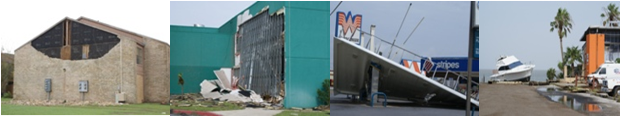
While Storm Surge Flooding often leaves behind the most catastrophic damage from a hurricane, perhaps the most awesome force at work during a hurricane is the high wind. Winds in hurricanes turn counter clockwise in the Northern Hemisphere, and become increasingly stronger as you approach the center of the storm in a region known as the eye wall. Destructive winds in the eye wall region of a hurricane reach speeds of 74 miles per hour or greater. For most storms reaching land, wind speed decreases rapidly within hours after moving ashore. In some cases, winds can stay above hurricane strength well inland such as in 1970 when Hurricane Celia produced hurricane force winds as far inland as Del Rio. Wind Intensity Hurricane force winds can easily destroy poorly constructed buildings and mobile homes, particularly in open, or exposed, areas. Debris such as signs, roofing material, and small items left outside become dangerous missiles in hurricanes. Extensive damage to transmission towers, power poles and lines, and water and underground utility lines can cause considerable disruption to modern life. Numerous uprooted trees and felled large limbs can block roads for hours or days after a storm. More intense hurricanes, containing winds above 120 mph, can produce widespread devastation that can take months to rebuild and repair. Hurricanes Hugo (1989) and Andrew (1992) each had a large swath of winds above these speeds when they struck South Carolina and south Florida, respectively. High rise buildings are also vulnerable to hurricane force winds, particularly on upper floors since hurricane wind speeds increase with height just above the earth's surface. High rise buildings that are not retrofitted with impact or pressure resistant glass can suffer a great deal of damage from any hurricane. Hurricane Ike in downtown Houston was the latest example of widespread damage to windows in high rise buildings. High rise buildings are limited across the Rio Grande Valley with the main concentration on the beaches in the Town of South Padre Island. Ironically, the strongest winds from a landfalling hurricane near the Texas and Mexico border would occur where most of the Valley's high rise buildings are located. Dolly’s Winds As Dolly pushed further inland after landfall, damaging winds gusting near or above hurricane force pushed into Harlingen and San Benito, continuing toward Santa Rosa in western Cameron County and stretching into eastern Hidalgo County near Weslaco and points north. In these areas, roofs were lifted and walls collapsed mainly in older structures. Thousands of trees and large limbs were felled by the winds. Gusts between 50 and 70 mph across highly populated portions of Hidalgo County, including Pharr, Edinburg, and McAllen, caused minor damage. The winds left widespread power outages in their wake, with nearly a quarter of a million customers in the Rio Grande Valley and Deep South Texas in the dark during the height of the storm. In harder hit areas near the coast, power was out for more than a week. |
Is Your Home Ready? A hurricane can strengthen rapidly, including just prior to landfall. When preparing for a hurricane, consider planning for a storm at least one Saffir Simpson Category higher than forecast. Tornadoes and Tropical Cyclones The landfall of Hurricane Alex (2010) about 100 miles south of Brownsville brought the favored right front quadrant across the Lower Rio Grande Valley, and at least a dozen radar signatures of potential small tornadoes were noted from the Gulf waters into Willacy and Cameron County. Three confirmed reports of tornadoes were received during the morning of June 30th; one appeared to be a long track rotating cell which raced from South Padre Island west, then southwest, through Port Isabel, Los Fresnos, and west of Brownsville. Two days after Alex made landfall, residual upper level energy combined with turning low level winds and very moist and unstable air to set off a low topped mini–supercell storm, which dropped a 100 mph producing tornado in Hebbronville. The July 2nd storm damaged hundreds of structures and several million dollars in damage. In 2011, distant circulation from Hurricane Arlene (landfall in northern Veracruz) produced a brief but damaging tornado in Hidalgo (city) on June 30th. Some hurricanes seem to produce no tornadoes, while others develop numerous tornadoes. Studies have shown that more than half of landfalling hurricanes produce at least one tornado. While Hurricane Beulah and Hurricane Ike were not too different in size, the angular track of Beulah produced dozens more tornadoes than the recurving track of Ike, which produced 29 total twisters, including one in Texas and 17 in Louisiana. In general, tornadoes associated with hurricanes are less intense that those that occur in the Great Plains. Nevertheless, combining the effects of tornadoes with the scope of hurricane force winds can result in substantial damage. Additional information on high wind and tornado preparedness can be found here. |
||||||||

