|
Hurricanes have been part of Texas' coastal history as long as the state has been inhabited. The Great Galveston Hurricane of September 8th 1900 remains the worst natural disaster in the United States in numbers of lives lost. At least 8,000 persons were killed in the storm. At the time, the population of galveston was slightly over 20,000.
Driven by winds in excess of 125 mph, raging Gulf waters covered the island to a depth up to 15 feet. Wooden buildings floated off pilings and smashed into one another. As buildings collapsed and disintegrated, occupants were thrust into the water and many drowned. The local weather office had sounded the alarm on the previous day, and over 10,000 residents fled inland to safety. Of the 10,000 who did not evacuate, at least eight in ten perished.
Deep South Texas History in Brief
While the Rio Grande Valley and Deep South Texas have rarely seen a storm the magnitude of the Great Galveston Hurricane, a number of significant events have affected the region since the late 19th century. The following is a summary of the most notable storms:
- September 1886: Nearly 26 inches of rain inundated the city of Brownsville from a storm that inched northward along the coast, later swamping Indianola with storm surge for the second time that year.
- September 4th and 5th, 1933: A 13 foot storm surge inundated coastal Cameron County. All dunes on south padre island were leveled, and over 40 separate cuts were produced by the battering surf. It was told that developed areas along the coast were abandoned until after World War II.
- September 20th-22nd, 1967: Hurricane Beulah: This storm remains the significant storm of record for longtime residents of the Rio Grande Valley and Deep South Texas. One or more impacts from wind, flooding, and storm surge affected people from Cameron to Zapata County. A ship in the Port of Brownsville observed winds of 136 mph. Gusts to 109 mph were recorded at the Brownsville Airport before the device was bent and inoperable, and gusts to 100 mph were noted as far inland as Pharr and Edinburg. An estimated storm tide of 8 to 14 feet swept South Padre Island, Port Isabel, and Boca Chica; tides were measured as high as 18 feet along the Cameron/Willacy County line south of Port Mansfield.
The slowing storm eased across Willacy and Brooks county, then moved briefly into Duval and Webb county before returning southwest and dissipating in northern Mexico. Beulah's slow movement and relatively large size dropped tremendous rains across Starr, Hidalgo, and Brooks County. Overflowing creeks inundated Falfurrias, and excessive water flowing down the Rio Grande and into adjacent floodways flooded homes up to their rooftops in Harlingen.
- August 10th, 1980 Hurricane Allen: This was a formidable Category 5 storm on the Saffir Simpson Hurricane Wind Scale just prior to entering the Gulf, but weakened to a Category 3 just prior to landfall near Port Mansfield as dry air infiltrated the cyclone as it slowly edged onshore. A brief wind gust of 138 mph was reported at Port Mansfield where significant damage occurred. Other reports had buildings in Brownsville inundated with 4 feet or water, most likely from rainfall. Uninhabited Padre Island had 68 new cuts from the impressive Storm Surge, which reached 12 feet at Port Mansfield and likely much higher to the north. The landfall of the most intense portion of the eyewall north of the Lower Rio Grande Valley spared the region from what would have been one of the worst storms on record.
- September 16th and 17th, 1988 Hurricane Gilbert: Gilbert became the strongest storm on record for the Atlantic basin for its time, packing 185 mph sustained winds and reaching a central pressure of 888 mb prior to ravaging Cozumel, México on its way toward the western Gulf. Gilbert weakened considerably after striking the northern Yucatan peninsula before making a modest comeback to Category 3 (115 mph) before making landfall in Tamaulipas. Impacts on the Rio Grande Valley were felt in stages. The first stage was a notable storm surge that flooded South Padre Island, and hurricane force wind gusts to 83 mph, in Coastal Cameron and Willacy County. The second stage was flooding along the Rio Grande, a result of very heavy rain flowing from the Sierra Madre Oriental into the basin. While no comparison with Beulah (1967) and 1971 (Fern and Edith), the flow would require the opening of the Rio Grande Flood Control Project (floodway).
|
Deep South Texas History in Brief, Continued
- August 23rd, 1999 Hurricane Bret: Bret will be remembered as the storm that split the population centers of the Lower Rio Grande Valley and the Corpus Christi area. A dangerous Category 4 storm just prior to landfall, Bret weakened slowly while approaching the coast, and decayed more rapidly soon after making landfall on uninhabited Padre Island in northern Kenedy County. While Bret's worst impacts largely affected cattle and mesquite, effects were felt from Sarita to Falfurrias,. where hurricane force winds and more than a foot of rain caused significant damage. A peak gust of 98 mph was recorded at the Brooks County Airport near Falfurrias, and sustained winds of 73 mph were recorded at the Rincon Del San Jose Buoy along the Laguna Madre in southern Kenedy County within the eyewall, before the equipment failed.
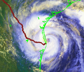
- July 23rd, 2008 Hurricane Dolly (below): Dolly served as a reminder to the residents of the Lower Texas coastline for the need to remain vigilant during each and every hurricane season. Dolly's wind and torrential rains caused damage and flooding across the Rio Grande Valley to the tune of over $1 billion, making it the fourth most destructive texas hurricane on record in raw value not adjusted for inflation.
Sustained winds for most were below hurricane force, but an area extending from the Town of South Padre Island through Laguna Vista and Port Isabel, Rio Hondo, Harlingen, and San Benito experienced frequent gusts to hurricane force, along with widespread minor to moderate wind damage to roofs, poorly designed buildings, trees, and power lines and poles. Rainfall of 12 to 18 inches or more produced widespread flooding in Cameron, Hidalgo, Willacy, and even Starr County.
- September 12th and 13th, 2008 Hurricane Ike: Texans and the nation will remember Ike as the storm that swallowed the Bolivar Peninsula northeast of Galveston, leaving nothing more than a few buildings standing after a storm surge of at least 17 feet scraped the area clean. Ike's large wingspan drove high water across the entire Gulf of America. It was ike which caused severe erosion on the South Padre Island beaches, which have finally recovered in time for the 2009 summer season.
- June 30th, 2010 Hurricane Alex: Rapid strengthening of Alex just prior to landfall along the central Tamaulipas coast, about 100 miles south of Brownsville, produced significant wind damage to a small fishing village, and severe flash flooding in Monterrey, Nuevo Léon, from more than 30 inches of rainfall in the foothills of the Sierra Madre Oriental. The Lower Rio Grande Valley escaped with a glancing blow of locally heavy rains and isolated tornadoes. Alex reminded the Valley of far reaching impacts from a tropical cyclone, as days of torrential rainfall in the Sierra Madre ultimately led to severe river flooding along the Rio Grande from Laredo to Rio Grande City, and activation of the Lower Rio Grande Flood Control Project (floodways) for the first time since 1988. River and floodway levels would reach their highest value since 1971.
The effects of a tropical storm or hurricane can go well inland past the Texas coast. Heavy rainfall, flooding, and even tornadoes can occur several hundred miles into the interior parts of the state. This week is a perfect time for emergency planners, city and county officials, the media, and the public to prepare for the tropical threats. Schools, hospitals, and nursing homes should test, review, and exercise their plans, making certain their employees are ready. Finally, everyone living or visiting the Texas coast must be prepared to move to safety in an organized and timely fashion if necessary. Click here for a detailed Texas Hurricane History, from the 14th through 20th century.
 |


